489:
59:
89:
42:
690:
328:
96:
66:
315:
The first post office established here was called Rue, which ran from 1902 to 1906. Another post office operated under the name Duffee from 1914 to 1959 and later, under the name Duffee Rural
Station from 1959 to 1969.
754:
312:, most of the inhabitants fled to find work elsewhere and the community suffered greatly in part. The community then saw a small resurgence in 1937 with the founding of the Columbus Planing Mill.
427:
759:
735:
304:
established a railroad through the village and, in 1906, was renamed from Rue to Duffee for a railroad surveyor. In 1915, a depot was constructed on the
58:
420:
308:
which opened the following year. By 1916, the place had two churches, a school, and a mill. In 1918, it had a recorded population of 85. After the
121:
88:
728:
371:
764:
636:
413:
253:
305:
721:
175:
405:
387:
697:
660:
437:
273:
180:
300:. It was a quiet community in its first thirty years, gaining some commerce when the Buckwalter Lumber Company of
41:
590:
575:
570:
281:
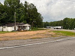
241:
153:
348:
540:
548:
601:
585:
667:
518:
513:
459:
214:
618:
595:
558:
508:
478:
269:
32:
628:
529:
333:
301:
297:
523:
367:
204:
705:
292:
Duffee, first known as
Liberty and later as Rue, was established as a religious community of
309:
748:
246:
280:, United States. Duffee is approximately 6.3 miles (10.1 km) east-southeast of
689:
361:
701:
452:
277:
168:
349:
U.S. Geological Survey
Geographic Names Information System: Duffee, Mississippi
610:
323:
163:
136:
123:
195:
651:‡This populated place also has portions in an adjacent county or counties
293:
229:
488:
221:
200:
500:
470:
409:
487:
755:
Unincorporated communities in Newton County, Mississippi
709:
18:
646:
627:
609:
557:
539:
499:
469:
252:
240:
228:
211:
194:
186:
174:
162:
152:
23:
729:
492:Map of Mississippi highlighting Newton County
421:
8:
95:
65:
736:
722:
428:
414:
406:
296:from the Liberty Church shortly after the
20:
760:Unincorporated communities in Mississippi
341:
251:
227:
193:
185:
151:
116:
50:
38:
239:
210:
173:
161:
7:
686:
684:
366:. Town Square Books, Incorporated.
708:. You can help Knowledge (XXG) by
436:Municipalities and communities of
306:Gulf, Mobile and Northern Railroad
284:south of Mississippi Highway 494.
14:
688:
326:
94:
87:
64:
57:
40:
637:Mississippi Choctaw Reservation
1:
108:Show map of the United States
704:state location article is a
765:Mississippi geography stubs
781:
683:
439:Newton County, Mississippi
390:. Jim Forte Postal History
360:Brieger, James F. (1997).
656:
485:
450:
117:
51:
39:
30:
270:unincorporated community
190:499 ft (152 m)
33:Unincorporated community
78:Show map of Mississippi
493:
491:
213: • Summer (
137:32.48944°N 88.92694°W
669:United States portal
363:Hometown Mississippi
46:Crossroads in Duffee
142:32.48944; -88.92694
133: /
102:Duffee, Mississippi
72:Duffee, Mississippi
25:Duffee, Mississippi
662:Mississippi portal
629:Indian reservation
494:
334:Mississippi portal
302:Union, Mississippi
298:American Civil War
717:
716:
678:
677:
373:978-1-886017-05-4
263:
262:
772:
738:
731:
724:
692:
685:
670:
663:
490:
462:
455:
445:
440:
430:
423:
416:
407:
400:
399:
397:
395:
384:
378:
377:
357:
351:
346:
336:
331:
330:
329:
310:Great Depression
218:
148:
147:
145:
144:
143:
138:
134:
131:
130:
129:
126:
109:
98:
97:
91:
79:
68:
67:
61:
44:
21:
780:
779:
775:
774:
773:
771:
770:
769:
745:
744:
743:
742:
681:
679:
674:
668:
661:
652:
642:
623:
605:
562:
560:
553:
535:
495:
483:
465:
460:
453:
446:
443:
438:
434:
404:
403:
393:
391:
388:"Newton County"
386:
385:
381:
374:
359:
358:
354:
347:
343:
332:
327:
325:
322:
290:
236:
212:
141:
139:
135:
132:
127:
124:
122:
120:
119:
113:
112:
111:
110:
107:
106:
105:
104:
103:
99:
82:
81:
80:
77:
76:
75:
74:
73:
69:
47:
35:
26:
19:
12:
11:
5:
778:
776:
768:
767:
762:
757:
747:
746:
741:
740:
733:
726:
718:
715:
714:
693:
676:
675:
673:
672:
665:
657:
654:
653:
650:
648:
644:
643:
641:
640:
633:
631:
625:
624:
622:
621:
615:
613:
607:
606:
599:
598:
593:
588:
583:
578:
573:
567:
565:
561:unincorporated
555:
554:
552:
551:
545:
543:
537:
536:
534:
533:
527:
521:
516:
511:
505:
503:
497:
496:
486:
484:
482:
481:
475:
473:
467:
466:
451:
448:
447:
435:
433:
432:
425:
418:
410:
402:
401:
379:
372:
352:
340:
339:
338:
337:
321:
318:
289:
286:
261:
260:
257:
250:
249:
244:
238:
237:
234:
232:
226:
225:
219:
209:
208:
198:
192:
191:
188:
184:
183:
178:
172:
171:
166:
160:
159:
156:
150:
149:
115:
114:
101:
100:
93:
92:
86:
85:
84:
83:
71:
70:
63:
62:
56:
55:
54:
53:
52:
49:
48:
45:
37:
36:
31:
28:
27:
24:
17:
13:
10:
9:
6:
4:
3:
2:
777:
766:
763:
761:
758:
756:
753:
752:
750:
739:
734:
732:
727:
725:
720:
719:
713:
711:
707:
703:
699:
698:Newton County
694:
691:
687:
682:
671:
666:
664:
659:
658:
655:
649:
645:
638:
635:
634:
632:
630:
626:
620:
617:
616:
614:
612:
608:
604:
603:
597:
594:
592:
589:
587:
584:
582:
579:
577:
574:
572:
569:
568:
566:
564:
556:
550:
547:
546:
544:
542:
538:
531:
528:
525:
522:
520:
517:
515:
512:
510:
507:
506:
504:
502:
498:
480:
477:
476:
474:
472:
468:
464:
463:
456:
449:
444:United States
441:
431:
426:
424:
419:
417:
412:
411:
408:
389:
383:
380:
375:
369:
365:
364:
356:
353:
350:
345:
342:
335:
324:
319:
317:
313:
311:
307:
303:
299:
295:
287:
285:
283:
279:
275:
274:Newton County
271:
267:
258:
255:
248:
245:
243:
233:
231:
223:
220:
216:
206:
205:Central (CST)
202:
199:
197:
189:
182:
179:
177:
170:
167:
165:
158:United States
157:
155:
146:
118:Coordinates:
90:
60:
43:
34:
29:
22:
16:
710:expanding it
695:
680:
600:
580:
458:
392:. Retrieved
382:
362:
355:
344:
314:
291:
265:
264:
15:
702:Mississippi
611:Ghost towns
591:Little Rock
576:Cedar Grove
571:Battlefield
563:communities
454:County seat
282:Little Rock
278:Mississippi
272:located in
169:Mississippi
140: /
749:Categories
320:References
256:feature ID
128:88°55′37″W
125:32°29′22″N
647:Footnotes
549:Conehatta
394:April 28,
242:Area code
196:Time zone
187:Elevation
602:Stratton
586:Lawrence
294:Baptists
230:ZIP code
519:Hickory
514:Decatur
461:Decatur
288:History
154:Country
619:Volcan
596:Perdue
581:Duffee
509:Chunky
479:Newton
471:Cities
370:
268:is an
266:Duffee
259:669484
181:Newton
176:County
696:This
559:Other
530:Union
501:Towns
235:39337
224:(CDT)
222:UTC-5
201:UTC-6
164:State
706:stub
541:CDPs
524:Lake
396:2020
368:ISBN
254:GNIS
247:601
215:DST
751::
700:,
457::
442:,
276:,
737:e
730:t
723:v
712:.
639:‡
532:‡
526:‡
429:e
422:t
415:v
398:.
376:.
217:)
207:)
203:(
Text is available under the Creative Commons Attribution-ShareAlike License. Additional terms may apply.