81:
48:
34:
348:
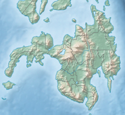
height of between 100 and 200 metres (330 and 660 ft) above sea level and divides the channel into two passages. At the head of the bay in
Kumalarang municipality are two small islands known as Fatima Islands. On the Zamboanga Sibugay side are Muda, Dacula and Paya islands. Other islands include Cabo, Putili, Dayana and Triton Island, on the eastern side in Vincenzo Sagun.
88:
55:
343:
Dumanquilas Bay covers an area of about 26,000 hectares (64,000 acres) with depths of between 12 and 120 feet (3.7 and 36.6 m). It is about 18 kilometres (11 mi) wide at its entrance between Lapat Point, the easternmost point of
Olutanga Island, and Dumanquilas Point in Vincenzo Sagun, and
347:
The bay contains several small islands, the largest of which is Igat Island located on its eastern side in
Margosatubig municipality which forms the western border of a small inlet called Igat Bay. Near the entrance to the bay, three small islands collectively known as Cherif Islands rise to a
508:
669:
501:
284:
on the western shore. An irregularly shaped peninsula extending to Flecha Point separates it from
Pagadian Bay to the east, while to the west, the bay connects with
494:
80:
352:
634:
548:
468:
47:
265:
664:
659:
138:
351:
Dumanquilas Bay receives inflow from several rivers and streams including
Lapuyan River, Kumal River and Muduing River. It faces threats from
297:
242:
373:
445:
553:
196:
654:
313:
232:
292:
island from the mainland of
Zamboanga. Politically, it is divided between the Zamboanga del Sur municipalities of
324:
317:
212:
584:
327:. It is known for its extensive mangrove shorelines and rich coral and fish diversity. It has been declared a
579:
395:
309:
217:
532:
422:
328:
518:
116:
589:
281:
277:
486:
648:
170:
293:
285:
237:
273:
124:
33:
305:
222:
153:
140:
261:
185:
323:
The bay is the location of the
Malangas Wharf, the shipping point for the
289:
269:
120:
594:
569:
469:"Table Talk: Trees for charcoal in lieu of coconut shell is everywhere"
301:
227:
490:
175:
374:""Let's talk coastal resource management" in bay cruise"
670:
398:. Official Gazette of the Republic of the Philippines
617:
603:
562:
541:
525:
205:
195:
191:
181:
169:
130:
112:
21:
344:extends some 23 kilometres (14 mi) inland.
333:Dumanquilas Bay Protected Landscape and Seascape
131:
423:"United States coast pilot, Philippine Islands"
308:, and the Zamboangay Sibugay municipalities of
502:
8:
446:"Sibugay mayor vows to stop illegal fishing"
509:
495:
487:
18:
444:Manaytay, Antonio M. (5 December 2007).
372:Manaytay, Antonio M. (3 December 2007).
288:through Canalizo Strait which separates
276:. It is shared between the provinces of
417:
415:
413:
364:
280:on the eastern and northern shore, and
87:
54:
467:Apostol, Mike S. (21 November 2011).
7:
635:Protected areas of the Philippines
563:Protected landscapes and seascapes
14:
425:. U.S. Coast and Geodetic Survey
201:Igat Island + 12 smaller islands
86:
79:
53:
46:
32:
396:"Proclamation No. 158, s. 1999"
67:Location within the Philippines
665:Landforms of Zamboanga Sibugay
660:Landforms of Zamboanga del Sur
1:
111:
100:Dumanquilas Bay (Philippines)
70:Show map of Mindanao mainland
264:on the southern side of the
16:Bay in Mindanao, Philippines
686:
631:
325:Malangas Coal Reservation
40:
31:
26:
585:Little Santa Cruz Island
355:and mangrove depletion.
655:Bays of the Philippines
580:Great Santa Cruz Island
256:(alternatively spelled
103:Show map of Philippines
329:marine protected area
154:7.67278°N 123.09611°E
618:Natural biotic areas
542:Protected landscapes
549:José Rizal Memorial
519:Zamboanga Peninsula
517:Protected areas in
266:Zamboanga Peninsula
260:) is an arm of the
150: /
117:Zamboanga Peninsula
590:Murcielagos Island
159:7.67278; 123.09611
642:
641:
604:Resource reserves
471:. Zamboanga Times
282:Zamboanga Sibugay
278:Zamboanga del Sur
251:
250:
677:
511:
504:
497:
488:
481:
480:
478:
476:
464:
458:
457:
455:
453:
441:
435:
434:
432:
430:
419:
408:
407:
405:
403:
392:
386:
385:
383:
381:
369:
165:
164:
162:
161:
160:
155:
151:
148:
147:
146:
143:
133:
104:
90:
89:
83:
71:
57:
56:
50:
36:
19:
685:
684:
680:
679:
678:
676:
675:
674:
645:
644:
643:
638:
627:
613:
599:
575:Dumanquilas Bay
558:
537:
521:
515:
485:
484:
474:
472:
466:
465:
461:
451:
449:
443:
442:
438:
428:
426:
421:
420:
411:
401:
399:
394:
393:
389:
379:
377:
371:
370:
366:
361:
353:illegal fishing
341:
258:Dumanguilas Bay
254:Dumanquilas Bay
247:
158:
156:
152:
149:
144:
141:
139:
137:
136:
108:
107:
106:
105:
102:
101:
98:
97:
96:
95:
94:Dumanquilas Bay
91:
74:
73:
72:
69:
68:
65:
64:
63:
62:
61:Dumanquilas Bay
58:
27:Dumanguilas Bay
22:Dumanquilas Bay
17:
12:
11:
5:
683:
681:
673:
672:
667:
662:
657:
647:
646:
640:
639:
632:
629:
628:
626:
625:
621:
619:
615:
614:
612:
611:
607:
605:
601:
600:
598:
597:
592:
587:
582:
577:
572:
566:
564:
560:
559:
557:
556:
551:
545:
543:
539:
538:
536:
535:
529:
527:
523:
522:
516:
514:
513:
506:
499:
491:
483:
482:
459:
436:
409:
387:
363:
362:
360:
357:
340:
337:
298:Vincenzo Sagun
272:island in the
249:
248:
246:
245:
243:Vincenzo Sagun
240:
235:
230:
225:
220:
215:
209:
207:
203:
202:
199:
193:
192:
189:
188:
183:
179:
178:
173:
167:
166:
134:
128:
127:
114:
110:
109:
99:
93:
92:
85:
84:
78:
77:
76:
75:
66:
60:
59:
52:
51:
45:
44:
43:
42:
41:
38:
37:
29:
28:
24:
23:
15:
13:
10:
9:
6:
4:
3:
2:
682:
671:
668:
666:
663:
661:
658:
656:
653:
652:
650:
637:
636:
630:
623:
622:
620:
616:
609:
608:
606:
602:
596:
593:
591:
588:
586:
583:
581:
578:
576:
573:
571:
568:
567:
565:
561:
555:
554:Mount Timolan
552:
550:
547:
546:
544:
540:
534:
531:
530:
528:
526:Natural parks
524:
520:
512:
507:
505:
500:
498:
493:
492:
489:
470:
463:
460:
447:
440:
437:
424:
418:
416:
414:
410:
397:
391:
388:
375:
368:
365:
358:
356:
354:
349:
345:
338:
336:
334:
331:known as the
330:
326:
321:
319:
315:
311:
307:
303:
299:
295:
291:
287:
283:
279:
275:
271:
267:
263:
259:
255:
244:
241:
239:
236:
234:
231:
229:
226:
224:
221:
219:
216:
214:
211:
210:
208:
204:
200:
198:
194:
190:
187:
184:
180:
177:
174:
172:
168:
163:
135:
129:
126:
122:
118:
115:
82:
49:
39:
35:
30:
25:
20:
633:
574:
473:. Retrieved
462:
450:. Retrieved
439:
427:. Retrieved
400:. Retrieved
390:
378:. Retrieved
367:
350:
346:
342:
332:
322:
294:Margosatubig
286:Sibuguey Bay
257:
253:
252:
238:Margosatubig
182:Part of
448:. MindaNews
376:. MindaNews
274:Philippines
268:in western
206:Settlements
157: /
145:123°05′46″E
132:Coordinates
125:Philippines
649:Categories
475:26 October
452:26 October
429:26 October
402:26 October
380:26 October
359:References
306:Kumalarang
223:Kumalarang
533:Pasonanca
339:Geography
335:in 1999.
262:Moro Gulf
186:Moro Gulf
142:7°40′22″N
314:Malangas
290:Olutanga
270:Mindanao
233:Malangas
121:Mindanao
113:Location
595:Selinog
570:Aliguay
302:Lapuyan
228:Lapuyan
197:Islands
610:Siocon
318:Alicia
213:Alicia
624:Buug
477:2015
454:2015
431:2015
404:2015
382:2015
316:and
310:Buug
304:and
218:Buug
171:Type
176:bay
651::
412:^
320:.
312:,
300:,
296:,
123:,
119:,
510:e
503:t
496:v
479:.
456:.
433:.
406:.
384:.
Text is available under the Creative Commons Attribution-ShareAlike License. Additional terms may apply.