97:
476:
724:
31:
185:
741:
192:
The area has had diminishing human settlement in the last few centuries, although many towns and villages remain scattered all over Zagora. The larger towns include
790:
427:
785:
168:
population: in the wintertime, they were moving their numerous flocks from the mountains to the coast. Historic population of Zagora has included the
780:
131:
The terrain in Zagora is fairly rugged: in the region immediately bordering the coastline, it is mostly flat but dry, mainly covered with
420:
173:
399:
393:
475:
727:
413:
96:
164:
The aforementioned geographical and climate conditions influenced the life patterns of the historically important
273:
125:
109:
121:
589:
549:
332:
241:
85:
627:
607:
436:
362:[Perception of the Spatial Extent of the Zagora Region in Selected Cartographic Sources]
158:
795:
509:
499:
43:
695:
645:
584:
579:
139:
132:
51:
323:, from Knin to Zadar, from Knin to Perković, where the line splits to Šibenik or to Split.
677:
229:
665:
660:
491:
450:
143:
349:
774:
312:
and
Benkovac, passing throughout Zagora, via the Dugopolje exit (to Split) and on to
17:
80:
means "beyond (the) hills", which is a reference to the fact that it is the part of
622:
539:
519:
305:
301:
289:
138:. More inland, greener pastures can be seen, as the climate and elevations change.
514:
233:
30:
257:
672:
655:
105:
65:
756:
743:
700:
617:
574:
559:
554:
221:
169:
269:
245:
147:
360:"Percepcija prostornog obuhvata Zagore u odabranim kartografskim izvorima"
705:
637:
599:
569:
564:
504:
465:
455:
337:
313:
277:
225:
197:
165:
142:
dominates the landscape. The land is interspersed with river canyons, of
104:
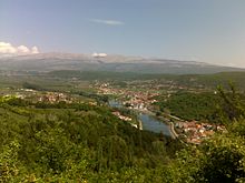
Dalmatian Zagora, in the strict sense, spans from the hinterland east of
81:
73:
612:
261:
217:
209:
184:
113:
69:
650:
534:
529:
524:
460:
405:
293:
265:
201:
151:
253:
309:
249:
237:
213:
183:
95:
29:
544:
320:
297:
205:
193:
117:
409:
359:
100:
An elevated karst area, typical of the
Dalmatian hinterland
688:
636:
598:
490:
483:
443:
120:corridor. Its borders are present in two counties:
421:
84:that is not coastal and the existence of the
59:
34:Approximate area of the Dalmatian Hinterland.
8:
157:One national park is located in Zagora, the
487:
428:
414:
406:
288:Two major roads intersect Zagora – the
88:where hills run parallel to the coast.
400:Dalmatinska zagora – nepoznata zemlja
7:
786:Geography of Split-Dalmatia County
25:
791:Geography of Šibenik-Knin County
723:
722:
474:
300:through Knin and Sinj, down to
319:The railway links Zagreb with
27:Geographical region of Croatia
1:
781:Historical regions in Croatia
368:Kartografija i geoinformacije
444:Principal historical regions
370:(in Croatian and English).
358:Vukosav, Branislav (2015).
812:
757:43.7117987°N 16.28400123°E
718:
472:
304:, and the recently built
64:) is the southern inland
762:43.7117987; 16.28400123
112:and continues south to
308:, which meanders near
189:
110:Bosnia and Herzegovina
101:
60:
55:
47:
35:
187:
99:
33:
18:Dalmatian hinterlands
333:Geography of Croatia
116:, just north of the
86:concordant coastline
40:Dalmatian Hinterland
753: /
220:. Villages include
108:to the border with
437:Regions of Croatia
394:Dalmatinska Zagora
350:Dalmatinska zagora
190:
159:Krka National Park
102:
68:in the historical
48:Dalmatinska zagora
36:
736:
735:
714:
713:
510:Croatian Littoral
292:which comes from
136:(maquis, macchia)
16:(Redirected from
803:
768:
767:
765:
764:
763:
758:
754:
751:
750:
749:
746:
726:
725:
488:
478:
430:
423:
416:
407:
383:
381:
379:
365:
354:
140:Karst topography
63:
21:
811:
810:
806:
805:
804:
802:
801:
800:
771:
770:
761:
759:
755:
752:
747:
744:
742:
740:
739:
737:
732:
710:
684:
678:Vukovar Plateau
632:
594:
484:Smaller regions
479:
470:
439:
434:
390:
377:
375:
363:
357:
352:
346:
329:
296:, crosses from
286:
182:
94:
28:
23:
22:
15:
12:
11:
5:
809:
807:
799:
798:
793:
788:
783:
773:
772:
734:
733:
731:
730:
719:
716:
715:
712:
711:
709:
708:
703:
698:
692:
690:
686:
685:
683:
682:
681:
680:
670:
669:
668:
663:
658:
648:
642:
640:
634:
633:
631:
630:
625:
620:
615:
610:
604:
602:
596:
595:
593:
592:
587:
582:
577:
572:
567:
562:
557:
552:
547:
542:
537:
532:
527:
522:
517:
512:
507:
502:
496:
494:
492:Croatia proper
485:
481:
480:
473:
471:
469:
468:
463:
458:
453:
451:Croatia proper
447:
445:
441:
440:
435:
433:
432:
425:
418:
410:
404:
403:
397:
389:
388:External links
386:
385:
384:
355:
345:
342:
341:
340:
335:
328:
325:
285:
284:Infrastructure
282:
181:
178:
122:Split-Dalmatia
93:
90:
61:Zagora dalmata
26:
24:
14:
13:
10:
9:
6:
4:
3:
2:
808:
797:
794:
792:
789:
787:
784:
782:
779:
778:
776:
769:
766:
729:
721:
720:
717:
707:
704:
702:
699:
697:
694:
693:
691:
687:
679:
676:
675:
674:
671:
667:
664:
662:
659:
657:
654:
653:
652:
649:
647:
646:Požega Valley
644:
643:
641:
639:
635:
629:
626:
624:
621:
619:
616:
614:
611:
609:
606:
605:
603:
601:
597:
591:
588:
586:
583:
581:
578:
576:
573:
571:
568:
566:
563:
561:
558:
556:
553:
551:
548:
546:
543:
541:
538:
536:
533:
531:
528:
526:
523:
521:
518:
516:
513:
511:
508:
506:
503:
501:
498:
497:
495:
493:
489:
486:
482:
477:
467:
464:
462:
459:
457:
454:
452:
449:
448:
446:
442:
438:
431:
426:
424:
419:
417:
412:
411:
408:
401:
398:
395:
392:
391:
387:
373:
369:
361:
356:
353:(in Croatian)
351:
348:
347:
343:
339:
336:
334:
331:
330:
326:
324:
322:
317:
315:
311:
307:
303:
299:
295:
291:
290:D1 state road
283:
281:
279:
275:
271:
267:
263:
259:
255:
251:
247:
243:
239:
235:
231:
227:
223:
219:
215:
211:
207:
203:
199:
195:
186:
179:
177:
175:
171:
167:
162:
160:
155:
153:
149:
145:
141:
137:
135:
129:
127:
123:
119:
115:
111:
107:
98:
91:
89:
87:
83:
79:
75:
71:
67:
62:
57:
53:
49:
45:
41:
32:
19:
738:
623:Ravni Kotari
540:Kvarner Gulf
520:Gorski Kotar
376:. Retrieved
371:
367:
318:
287:
191:
163:
156:
154:and others.
133:
130:
126:Šibenik-Knin
103:
77:
39:
37:
760: /
661:Fruška Gora
258:Cista Provo
180:Settlements
76:. The name
56:La Morlacca
775:Categories
748:16°17′02″E
745:43°42′42″N
673:Podunavlje
656:Cvelferija
402:(archived)
396:(archived)
306:A1 highway
274:Šestanovac
72:region of
66:hinterland
701:Podravina
618:Morlachia
575:Turopolje
560:Moslavina
555:Morlachia
550:Međimurje
515:Dubašnica
222:Biskupija
170:Illyrians
92:Geography
796:Dalmatia
728:Category
706:Posavina
638:Slavonia
608:Bukovica
600:Dalmatia
590:Žumberak
570:Prigorje
565:Pokuplje
505:Bilogora
500:Banovina
466:Slavonia
456:Dalmatia
338:Morlachs
327:See also
278:Zmijavci
226:Kistanje
172:and the
166:shepherd
82:Dalmatia
74:Dalmatia
70:Croatian
44:Croatian
696:Baranja
613:Konavle
585:Zagorje
580:Vinodol
344:Sources
280:, etc.
262:Prgomet
218:Imotski
210:Vrgorac
114:Vrgorac
106:Šibenik
52:Italian
689:Others
666:Spačva
651:Syrmia
628:Zagora
535:Krbava
530:Kosinj
525:Kordun
461:Istria
378:8 July
294:Zagreb
270:Lovreć
266:Hrvace
246:Aržano
234:Unešić
230:Kijevo
202:Vrlika
174:Vlachs
152:Cetina
148:Čikola
134:makija
78:zagora
364:(PDF)
314:Ploče
310:Zadar
302:Split
250:Dicmo
242:Ružić
238:Oklaj
214:Trilj
198:Drniš
188:Trilj
545:Lika
380:2019
374:(23)
321:Knin
298:Lika
216:and
206:Sinj
194:Knin
144:Krka
124:and
118:Neum
38:The
254:Muć
58:or
777::
372:14
366:.
316:.
276:,
272:,
268:,
264:,
260:,
256:,
252:,
248:,
244:,
240:,
236:,
232:,
228:,
224:,
212:,
208:,
204:,
200:,
196:,
176:.
161:.
150:,
146:,
128:.
54::
50:,
46::
429:e
422:t
415:v
382:.
42:(
20:)
Text is available under the Creative Commons Attribution-ShareAlike License. Additional terms may apply.