39:
175:
270:
55:
62:
289:
with embrasures for three guns. In the northwest corner is a defensible building of three ranges. The central one facing the ditch consists of guardrooms, between which the main entrance of the fort passes in a passageway, having crossed the ditch by means of a bridge. The northern range is a
313:), the southernmost four being on a higher level than the other three. Originally there was an expense magazine to support these positions, but it has been demolished. The site of the Dynamite Gun position is close to the present dining area, towards the north of the fort.
257:(formerly CPFS) at cost price plus an interest-free mortgage of £1,800 transferred to the Council. It has been run by the Field Studies Council as a field centre, and is now used by many thousands of students each year. 70% of the students are
198:, in 1850. There is no record of when construction started, but the work was completed by 1858 and a date of 1856 is inscribed above the main gate. The fort was intended to protect the anchorage at the mouth of Milford Haven by providing
166:
and offers residential and non-residential fieldwork for schools, colleges and universities, holiday accommodation and professional and leisure courses in natural history and arts.
298:, now with a modern accommodation building over it. The gun battery is at the eastern end of the fort on the cliffs overlooking the haven. There are seven positions intended for
476:
461:
281:
cut into the rock, which extends across the promontory and down to the shoreline on either side. The landward (western) side of the fort facing the ditch consists of a
210:. In 1876 there was a recommendation that the fort be re-armed with larger and more modern guns, but this was never implemented. The fort was the site for trials of
417:
294:
for the ordinary soldiers and the southern range contains various storerooms. Further along the northern edge is the officers' quarters and the main
408:
222:
195:
374:
Reports from
Commissioners: Sixteen Volumes: Coal Mines, Inland Revenue, Post Office, Ordnance Survey, Defences of the United Kingdom
466:
249:
purchased Dale Fort for £6,000 in 1946 which it leased to the
Council for the Promotion of Field Studies in August. The Wardens of
456:
372:
471:
404:
54:
38:
246:
174:
269:
377:, Her Majesty's Stationery Office (HMSO), London 1860 (Report commencing p. 431 – p. xxxix of the report)
278:
254:
163:
295:
229:, who converted it into a home for his family, but it changed hands when he died in 1925. During the
207:
258:
151:
28:
191:
187:
140:
230:
335:
226:
211:
299:
273:
The bastion projecting into the ditch, which defends the landward approach to Dale Fort
450:
234:
155:
215:
203:
386:
Brief
History and Handbook to Nature Reserves: West Wales Naturalists' Trust. 1975
399:
245:-watching station, but was returned to the owner at the end of hostilities. The
277:
The fort occupies the easternmost end of the promontory; it is protected by a
242:
238:
190:
on this site in 1829, the present fort is a result of a recommendation by Sir
147:
432:
419:
363:
From a photograph included in the "Victorian Forts and
Artillery" reference.
199:
305:
291:
282:
250:
310:
286:
268:
173:
159:
143:
261:
biologists working on the nearby shores to understand ecology.
253:
operated from Dale Fort initially. In 1959, it was sold to the
178:
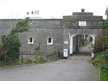
The main entrance to Dale Fort. The plaque reads "V.R. (
126:
118:
107:
102:
94:
84:
79:
21:
330:
328:
326:
218:in the 1890s, but the design was not adopted.
8:
477:Field studies centres in the United Kingdom
285:wall, in the centre of which is a D-shaped
462:Grade II listed buildings in Pembrokeshire
18:
322:
309:(i.e. on open mountings firing over a
186:Although there was a proposal for an
7:
196:Inspector-General of Fortifications
162:. It is one of the centres run by
16:19th-century coastal fort in Wales
14:
61:
233:, the fort was requisitioned by
60:
53:
37:
345:. Victorian Forts and Artillery
221:In 1902, the fort was sold to
1:
400:Dale Fort Field Study Centre
493:
202:with the nearby forts at
48:
36:
26:
467:History of Pembrokeshire
343:www.victorianforts.co.uk
247:West Wales Field Society
31:, Pembrokeshire, Wales
457:Forts in Pembrokeshire
274:
216:Pneumatic Dynamite Gun
183:
146:at Dale Head, a rocky
139:is a mid-19th-century
43:Dale Fort study centre
472:Grade II listed forts
272:
255:Field Studies Council
225:A. Owen-Evans of the
177:
164:Field Studies Council
433:51.70320°N 5.15202°W
122:Field studies centre
429: /
336:"Dale (Point) Fort"
152:Dale, Pembrokeshire
438:51.70320; -5.15202
275:
223:Lieutenant-Colonel
184:
200:interlocking fire
192:John Fox Burgoyne
188:artillery battery
141:coastal artillery
134:
133:
484:
444:
443:
441:
440:
439:
434:
430:
427:
426:
425:
422:
411:
387:
384:
378:
370:
364:
361:
355:
354:
352:
350:
340:
332:
231:Second World War
80:Site information
64:
63:
57:
41:
32:
19:
492:
491:
487:
486:
485:
483:
482:
481:
447:
446:
437:
435:
431:
428:
423:
420:
418:
416:
415:
407:
396:
391:
390:
385:
381:
371:
367:
362:
358:
348:
346:
338:
334:
333:
324:
319:
300:68-pounder guns
267:
227:Royal Engineers
212:Edmund Zalinski
208:West Blockhouse
180:Victoria Regina
172:
87:the public
86:
75:
74:
73:
72:
71:
70:
69:
65:
44:
27:
17:
12:
11:
5:
490:
488:
480:
479:
474:
469:
464:
459:
449:
448:
413:
412:
405:grid reference
402:
395:
394:External links
392:
389:
388:
379:
365:
356:
321:
320:
318:
315:
266:
263:
171:
168:
132:
131:
128:
124:
123:
120:
116:
115:
109:
105:
104:
100:
99:
96:
92:
91:
88:
82:
81:
77:
76:
67:
66:
59:
58:
52:
51:
50:
49:
46:
45:
42:
34:
33:
24:
23:
15:
13:
10:
9:
6:
4:
3:
2:
489:
478:
475:
473:
470:
468:
465:
463:
460:
458:
455:
454:
452:
445:
442:
410:
406:
403:
401:
398:
397:
393:
383:
380:
376:
375:
369:
366:
360:
357:
344:
337:
331:
329:
327:
323:
316:
314:
312:
308:
307:
301:
297:
293:
288:
284:
280:
271:
264:
262:
260:
256:
252:
248:
244:
240:
237:for use as a
236:
235:the Admiralty
232:
228:
224:
219:
217:
213:
209:
205:
201:
197:
193:
189:
181:
176:
169:
167:
165:
161:
157:
156:Milford Haven
153:
149:
145:
142:
138:
129:
125:
121:
117:
113:
110:
106:
101:
97:
93:
89:
83:
78:
56:
47:
40:
35:
30:
25:
20:
414:
382:
373:
368:
359:
347:. Retrieved
342:
303:
276:
220:
204:Thorn Island
185:
179:
136:
135:
111:
103:Site history
85:Open to
436: /
265:Description
119:In use
451:Categories
421:51°42′12″N
317:References
239:degaussing
154:, west of
148:promontory
424:5°09′07″W
283:loopholed
137:Dale Fort
127:Materials
95:Condition
68:Dale Fort
22:Dale Fort
409:SM823052
306:barbette
296:magazine
292:barracks
251:Skokholm
182:) 1856".
98:Complete
311:parapet
302:firing
287:bastion
259:A-Level
170:History
114:1851–56
349:27 May
194:, the
339:(PDF)
279:ditch
160:Wales
150:near
130:Stone
108:Built
351:2016
243:mine
241:and
206:and
144:fort
29:Dale
304:en
214:'s
158:in
453::
341:.
325:^
90:No
353:.
112:c
Text is available under the Creative Commons Attribution-ShareAlike License. Additional terms may apply.