434:
446:
190:
223:
532:
173:
89:
recognizable by the paved sections of the dike between the asphalted road sections after the dike reinforcements. Waiting for all the water to be drained through the de-inundation lock would take too long. Sheet pile walls have been installed in the dike to prevent the holes from wearing too far. They are covered with concrete beams, visible on the outside of the dike.
110:
flowing water that rapidly washes away the ground on the inside of the dike to great depths. Depths of 20 meters are not uncommon. Even after almost three centuries, the Wheels still bear witness to the calamity of drowned people and animals and the loss of homes and possessions, with all its consequences. The dike residents were generally not very wealthy.
230:
197:
92:
The overflow areas have been preserved and were even adapted to the new standards with the dike reinforcements of 1996. The level difference with Tiel is approximately 7.20 meters. In 1995, after the near-flood disaster, a water board official deemed it irresponsible to build large-scale houses here.
109:
A separate book could be written about the phenomenon of dike breaches in the entire
Tielerwaard region. For Dalem, the consequences of the dike breaches in 1726, 1728, and 1729 are still visible, and the wheels formed at that time are integral parts of the landscape. A wheel is formed by the inward
105:
The history of the Dalem lock dates back to 1284 when the Lords of the Vijf
Heerenlanden decided to build a dike ring around their area (the Diefdijk) and also to have the option to drain the excess water through an outlet lock at Dalem. As was customary at the time, this lock would be entirely made
88:
r (dutch: Maas Rivier) fail. After a flood, this water can be drained again into the lower course of the river through excavations of the overflow areas and through the Dalem de-inundation lock. It is also possible to excavate three dike sections at Dalem to accelerate the drainage of water. This is
44:
In 1254, Floris van Dalem was enfeoffed with the lordship of Dalem by Jan van der Leede and Hugo van Arkel. In 1423, his descendant Lord Floris van Dalem sold the lordships of Dalem, Schuvenoord, and Staden for 2260 crowns to the
Gelderland Duke Arnoud. From him, the ownership passed to Charles of
68:
The natural location of Dalem, in the lowest part of the
Tielerwaard, has regularly caused flooding over the centuries. Together with the entire Betuwe region, the Tielerwaard served as a water catchment area during times of extremely high water, protecting the even lower-lying
132:
and stayed at the (old) Doelen (Molenstraat). When he visited the threatened areas and was on the
Dalemsedijk with his carriage, a part of the dike broke. The king had to be taken away by boat. When the formwork collapsed on the Kortendijk on January 30, the water from the
97:, the inflowing water will be captured inland by the raised dikes, and the water level could possibly reach a height of 10 meters. Due to the enormous water force, many houses will be swept away (see below 1809).
106:
of wood. The first stone for the lock in its approximately current form was laid in 1661. Dike construction began in the 13th century, before which there were no dike breaches because there were no dikes.
60:, as he remained lord of Dalem until his death in 1566. A document from 1518 mentions that besides a chapel, Dalem had 13 to 18 houses. However, these houses were so poor that no rent was collected.
113:
Dike breaches at that time were usually caused by ice dams in the river, blocking the flow of water. Sometimes the dams became so high that houses on the outside of the dike were destroyed.
120:
area, and work began on
January 18 to create outlets in the Dalem overflow areas. By January 25, 1809, so much water had flowed down through the Betuwe region that the city of
137:
flowed into the lower city through the
Hoogstraat and the alleys. Soldiers and citizens managed to close the gaps with great effort and prevented the city from being flooded.
573:
52:
On June 16, 1518, other sources mention 1517, Duke
Charles granted the lordship of Dalem for life to Christoffel, Count of Meurs. This warrior was favored by both
597:
53:
433:
592:
258:
402:
607:
445:
189:
414:
566:
222:
81:
559:
57:
394:
290:
172:
373:
383:
602:
80:
Lower Dalem is the lowest-lying area of the
Tielerwaard, where river water will flow in case of
543:
74:
128:(it was during the French period) unexpectedly arrived in the city with his entourage from
475:
32:. Until January 1, 1818, Dalem was the name of the municipality, which was then renamed
145:
70:
586:
539:
305:
21:
531:
125:
116:
In the year 1809, on the night of
January 14 to 15, there was a dike breach in the
295:
117:
45:
Egmont, Duke of Guelders, who first pawned Dalem to Willem van Rossum for 300
25:
273:
260:
364:
315:
121:
17:
141:
84:. It is essentially located in a basin, especially if the dikes of the
46:
390:
369:
129:
16:
Dalem is a village in the Tielerwaard region in the municipality of
134:
85:
33:
29:
500:
94:
209:
Location in the province of South Holland in the Netherlands
547:
28:
until 1986 and was part of the former municipality of
413:
401:
380:
363:
355:
347:
342:
334:
326:
321:
311:
301:
289:
156:
567:
507:(in Dutch). Het Waterschapshuis. 24 July 2019
8:
574:
560:
153:
462:
429:
400:
362:
341:
333:
320:
288:
253:
181:
169:
470:
468:
466:
412:
379:
354:
346:
325:
310:
300:
151:Village in South Holland, Netherlands
7:
528:
526:
476:"Kerncijfers wijken en buurten 2021"
598:Former municipalities of Gelderland
330:1.50 km (0.58 sq mi)
546:. You can help Knowledge (XXG) by
14:
593:Populated places in South Holland
93:In the event of a dike breach in
530:
444:
432:
228:
221:
195:
188:
171:
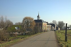
140:There was also a dike breach at
505:Actueel Hoogtebestand Nederland
24:. The village belonged to the
1:
608:South Holland geography stubs
229:
196:
480:Central Bureau of Statistics
242:Location in the Netherlands
20:, in the Dutch province of
624:
525:
501:"Postcodetool for 4213CD"
359:590/km (1,500/sq mi)
254:
212:Show map of South Holland
182:
170:
163:
338:0.3 m (1.0 ft)
245:Show map of Netherlands
542:location article is a
101:The de-inundation lock
26:province of Gelderland
451:Dutch Reformed church
382: • Summer (
148:region was submerged.
356: • Density
274:51.82778°N 5.00944°E
124:was in danger. King
270: /
348: • Total
327: • Total
47:Rhineland guilders
555:
554:
439:Postcard of Dalem
423:
422:
279:51.82778; 5.00944
144:, and the entire
58:Emperor Charles V
615:
576:
569:
562:
534:
527:
517:
516:
514:
512:
497:
491:
490:
488:
486:
472:
448:
436:
387:
285:
284:
282:
281:
280:
275:
271:
268:
267:
266:
263:
246:
232:
231:
225:
213:
199:
198:
192:
175:
154:
75:Vijfheerenlanden
623:
622:
618:
617:
616:
614:
613:
612:
583:
582:
581:
580:
523:
521:
520:
510:
508:
499:
498:
494:
484:
482:
474:
473:
464:
459:
452:
449:
440:
437:
428:
409:
381:
278:
276:
272:
269:
264:
261:
259:
257:
256:
250:
249:
248:
247:
244:
243:
240:
239:
238:
237:
233:
216:
215:
214:
211:
210:
207:
206:
205:
204:
200:
178:
166:
159:
152:
103:
66:
64:Dalem and water
42:
12:
11:
5:
621:
619:
611:
610:
605:
600:
595:
585:
584:
579:
578:
571:
564:
556:
553:
552:
535:
519:
518:
492:
461:
460:
458:
455:
454:
453:
450:
443:
441:
438:
431:
427:
424:
421:
420:
417:
411:
410:
407:
405:
399:
398:
388:
378:
377:
367:
361:
360:
357:
353:
352:
349:
345:
344:
340:
339:
336:
332:
331:
328:
324:
323:
319:
318:
313:
309:
308:
303:
299:
298:
293:
287:
286:
252:
251:
241:
235:
234:
227:
226:
220:
219:
218:
217:
208:
202:
201:
194:
193:
187:
186:
185:
184:
183:
180:
179:
176:
168:
167:
164:
161:
160:
157:
150:
146:Alblasserwaard
126:Louis Napoleon
102:
99:
71:Alblasserwaard
65:
62:
41:
38:
13:
10:
9:
6:
4:
3:
2:
620:
609:
606:
604:
601:
599:
596:
594:
591:
590:
588:
577:
572:
570:
565:
563:
558:
557:
551:
549:
545:
541:
540:South Holland
536:
533:
529:
524:
506:
502:
496:
493:
481:
477:
471:
469:
467:
463:
456:
447:
442:
435:
430:
425:
418:
416:
406:
404:
396:
392:
389:
385:
375:
371:
368:
366:
358:
350:
337:
329:
317:
314:
307:
306:South Holland
304:
297:
294:
292:
283:
255:Coordinates:
224:
191:
177:View on Dalem
174:
162:
155:
149:
147:
143:
138:
136:
131:
127:
123:
119:
114:
111:
107:
100:
98:
96:
90:
87:
83:
82:dike breaches
78:
76:
72:
63:
61:
59:
55:
50:
48:
39:
37:
35:
31:
27:
23:
22:South Holland
19:
548:expanding it
537:
522:
509:. Retrieved
504:
495:
483:. Retrieved
479:
415:Dialing code
312:Municipality
139:
115:
112:
108:
104:
91:
79:
67:
54:Duke Charles
51:
43:
15:
403:Postal code
296:Netherlands
277: /
135:Linge River
118:Over-Betuwe
587:Categories
457:References
343:Population
265:05°00′34″E
262:51°49′40″N
86:Meuse Rive
603:Gorinchem
365:Time zone
335:Elevation
316:Gorinchem
122:Gorinchem
18:Gorinchem
302:Province
142:Kedichem
426:Gallery
291:Country
165:Village
40:History
130:Vianen
538:This
511:3 May
485:3 May
391:UTC+2
370:UTC+1
236:Dalem
203:Dalem
158:Dalem
34:Vuren
30:Vuren
544:stub
513:2022
487:2022
419:0183
408:4213
395:CEST
322:Area
95:Tiel
73:and
56:and
384:DST
374:CET
351:885
589::
503:.
478:.
465:^
77:.
49:.
36:.
575:e
568:t
561:v
550:.
515:.
489:.
397:)
393:(
386:)
376:)
372:(
Text is available under the Creative Commons Attribution-ShareAlike License. Additional terms may apply.