38:
29:
342:
The
Davoust River has its source at the mouth of Lake Mouliers (length: 2.9 kilometres (1.8 mi), wide: 2.4 kilometres (1.5 mi); altitude: 244 metres (801 ft)).
355:
2.0 kilometres (1.2 mi) southwesterly crossing
Davoust Lake (length: 2.4 kilometres (1.5 mi); altitude: 213 metres (699 ft), to its mouth;
294:. The surface of the river is usually frozen from early November to mid-May, however, safe ice circulation is generally from mid-November to mid-April.
552:
409:
212:
345:
From the mouth of
Mouliers Lake, the Davoust River flows over 19.8 kilometres (12.3 mi) through the following segments:
439:
River segments measured from the Atlas of Canada (published on the
Internet) of the Department of Natural Resources Canada.
127:
290:
The
Davoust River flows entirely in the forest and marsh zone at the East of Lake Dusaux, which is crossed by the
537:
467:
428:
317:
321:
511:
448:
494:
489:
484:
276:
194:
109:
310:
516:
389:
374:
335:
328:
291:
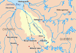
268:
178:
546:
449:
Commission de toponymie du Quebec - Bank of Place Names - Toponym: "Davoust River"
173:
521:
378:
349:
6.9 kilometres (4.3 mi) northwesterly to a creek (coming from the North);
272:
190:
105:
76:
479:
227:
214:
142:
129:
527:
506:
382:
37:
28:
367:
532:
408:
The toponym "Davoust River" was formalized on
December 5, 1968, at the
396:
284:
280:
198:
113:
66:
56:
352:
5.4 kilometres (3.4 mi) West to the East shore of
Davoust Lake;
373:
96.4 kilometres (59.9 mi) Southeast of the confluence of the
309:
North side: Desorsons Lake, Rodayer Lake, Chaboullie Lake,
388:
61.6 kilometres (38.3 mi) northwest of the mouth of
297:
A forest road passes on the East side of
Mouliers Lake.
366:
119.3 kilometres (74.1 mi) north-west of downtown
305:
The hydrographic slopes near the
Davoust River are:
253:
243:
204:
184:
172:
158:
119:
99:
91:
82:
72:
62:
52:
47:
21:
362:The mouth of the Davoust River is located at:
267:is a tributary of the northeast shore of the
8:
395:83.3 kilometres (51.8 mi) east of the
358:5.5 kilometres (3.4 mi) west to mouth.
36:
522:Eeyou Istchee Baie-James (municipality)
421:
273:Eeyou Istchee Baie-James (municipality)
191:Eeyou Istchee Baie-James (municipality)
106:Eeyou Istchee Baie-James (municipality)
77:Eeyou Istchee Baie-James (municipality)
18:
327:South side: Katutupisisikanuch Lake,
7:
316:East side: Kapitastikweyack Creek,
271:, flowing into the municipality of
275:, in the administrative region of
14:
410:Commission de toponymie du Quebec
27:
42:Harricana River basin in yellow
206: • coordinates
121: • coordinates
1:
83:Physical characteristics
245: • elevation
160: • elevation
495:GPX (secondary coordinates)
257:19.8 km (12.3 mi)
186: • location
101: • location
569:
490:GPX (primary coordinates)
465:Map all coordinates using
168:
87:
35:
26:
553:Rivers of Nord-du-Québec
538:List of rivers of Quebec
473:Download coordinates as:
334:West side: Dusaux Lake,
164:244 m (801 ft)
16:River in Quebec, Canada
485:GPX (all coordinates)
322:Matawawaskweyau River
228:50.74833°N 77.86667°W
143:50.74833°N 79.86667°W
416:Notes and references
318:Pauschikushish River
249:0 m (0 ft)
233:50.74833; -77.86667
224: /
148:50.74833; -79.86667
139: /
261:
260:
560:
524:, a municipality
451:
446:
440:
437:
431:
426:
311:Utamikaneu River
239:
238:
236:
235:
234:
229:
225:
222:
221:
220:
217:
161:
154:
153:
151:
150:
149:
144:
140:
137:
136:
135:
132:
122:
102:
40:
31:
19:
568:
567:
563:
562:
561:
559:
558:
557:
543:
542:
503:
502:
501:
500:
499:
460:
455:
454:
447:
443:
438:
434:
429:Atlas of Canada
427:
423:
418:
406:
303:
246:
232:
230:
226:
223:
218:
215:
213:
211:
210:
207:
187:
159:
147:
145:
141:
138:
133:
130:
128:
126:
125:
120:
100:
95:Lake Mouilliers
43:
17:
12:
11:
5:
566:
564:
556:
555:
545:
544:
541:
540:
535:
530:
525:
519:
517:Nottaway River
514:
509:
498:
497:
492:
487:
482:
476:
470:
463:
462:
461:
459:
456:
453:
452:
441:
432:
420:
419:
417:
414:
405:
402:
401:
400:
393:
390:Soscumica Lake
386:
381:(connected to
375:Nottaway River
371:
360:
359:
356:
353:
350:
340:
339:
336:Nottaway River
332:
329:Nottaway River
325:
314:
302:
299:
292:Nottaway River
277:Nord-du-Québec
269:Nottaway River
259:
258:
255:
251:
250:
247:
244:
241:
240:
208:
205:
202:
201:
195:Nord-du-Québec
188:
185:
182:
181:
179:Nottaway River
176:
170:
169:
166:
165:
162:
156:
155:
123:
117:
116:
110:Nord-du-Québec
103:
97:
96:
93:
89:
88:
85:
84:
80:
79:
74:
70:
69:
64:
60:
59:
54:
50:
49:
45:
44:
41:
33:
32:
24:
23:
15:
13:
10:
9:
6:
4:
3:
2:
565:
554:
551:
550:
548:
539:
536:
534:
531:
529:
526:
523:
520:
518:
515:
513:
510:
508:
505:
504:
496:
493:
491:
488:
486:
483:
481:
478:
477:
475:
474:
469:
468:OpenStreetMap
466:
457:
450:
445:
442:
436:
433:
430:
425:
422:
415:
413:
411:
403:
398:
394:
391:
387:
384:
380:
376:
372:
369:
365:
364:
363:
357:
354:
351:
348:
347:
346:
343:
337:
333:
330:
326:
323:
319:
315:
312:
308:
307:
306:
300:
298:
295:
293:
288:
286:
282:
278:
274:
270:
266:
265:Davoust River
256:
252:
248:
242:
237:
209:
203:
200:
196:
192:
189:
183:
180:
177:
175:
171:
167:
163:
157:
152:
124:
118:
115:
111:
107:
104:
98:
94:
90:
86:
81:
78:
75:
71:
68:
65:
61:
58:
55:
51:
46:
39:
34:
30:
25:
20:
512:Rupert's Bay
472:
471:
464:
444:
435:
424:
407:
361:
344:
341:
304:
296:
289:
264:
262:
231: /
146: /
379:Rupert Bay
219:77°52′00″W
216:50°44′54″N
134:79°52′00″W
131:50°44′54″N
528:James Bay
507:James Bay
383:James Bay
301:Geography
547:Category
458:See also
404:Toponymy
368:Matagami
63:Province
48:Location
533:Nunavik
399:border.
397:Ontario
53:Country
22:Davoust
285:Canada
281:Quebec
254:Length
199:Quebec
114:Quebec
92:Source
73:Region
67:Quebec
57:Canada
377:with
283:, in
279:, in
174:Mouth
263:The
480:KML
549::
412:.
385:);
320:,
287:.
197:,
193:,
112:,
108:,
392:;
370:;
338:.
331:;
324:;
313:;
Text is available under the Creative Commons Attribution-ShareAlike License. Additional terms may apply.