45:
148:
141:
185:
173:
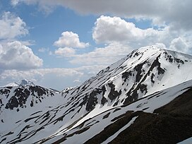
352:, the massif presents a rugged structure with a combination of scaly and blocky formations. It has an elongated shape, aligned in a nearly north-south orientation, featuring a relatively gentle relief. Its two prominent peaks showcase typical dome-like shapes. The slopes of the mountain bear the marks of glacial
364:
Vegetation on Deshat varies with altitude, encompassing oak forests from 700–1,000 m (2,300–3,300 ft), with beech forests extending up to 1,600–1,700 m (5,200–5,600 ft), and lush alpine meadows rising above 1,700 m (5,600 ft). Additionally, sulfur deposits can be found
325:
The Deshat watershed serves as a dividing line between both countries. The larger section of the massif is located within
Albania proper, including the two highest peaks,
44:
97:
435:
214:
200:
140:
430:
374:
90:
315:
210:
252:
70:
80:
291:
240:
264:
311:
190:
322:
valley to the west, and Radikë valley (the right branch of the Black Drin) to the east.
440:
221:
424:
318:
basin to the south (known as Gryka e Radikës), Banja stream valley to the north,
319:
112:
99:
349:
273:
346:
245:
314:. Positioned at the southeastern tip of the range, it is bounded by the
307:
178:
353:
342:
299:
269:
257:
60:
17:
398:(1.2 ed.). Tiranë: Qendra e Studimeve Gjeografike. p. 592.
303:
228:
365:
at the foothills of Kërçinë, in the area known as Kërçisht.
27:
Mountain on the border between
Albania and North Macedonia
413:. Tiranë: Akademia e Shkencave e RPSSH. p. 1248.
263:
251:
239:
234:
220:
206:
196:
166:
128:
89:
79:
69:
59:
54:
32:
8:
29:
49:Velivar is the highest peak of the massif
386:
306:mountain range, on the border between
7:
356:, particularly on the eastern side.
285:
25:
329:2,372 m (7,782 ft) and
183:
171:
146:
139:
43:
396:Gjeografia Fizike e Shqipërisë
333:2,342 m (7,684 ft).
147:
1:
411:Fjalori Enciklopedik Shqiptar
375:List of mountains in Albania
65:2,372 m (7,782 ft)
457:
436:Two-thousanders of Albania
341:Composed predominantly of
75:409 m (1,342 ft)
295:
133:
42:
37:
201:Central Mountain Region
113:41.637354°N 20.525035°E
85:51 m (167 ft)
394:Kabo, Mevlan (1991).
431:Mountains of Albania
409:Buda, Aleks (1985).
118:41.637354; 20.525035
215:Mavrovo and Rostuša
109: /
55:Highest point
345:and partially of
288:
279:
278:
16:(Redirected from
448:
415:
414:
406:
400:
399:
391:
302:situated in the
297:
289:
286:
224:
189:
187:
186:
177:
175:
174:
150:
149:
143:
124:
123:
121:
120:
119:
114:
110:
107:
106:
105:
102:
47:
30:
21:
456:
455:
451:
450:
449:
447:
446:
445:
421:
420:
419:
418:
408:
407:
403:
393:
392:
388:
383:
371:
362:
339:
312:North Macedonia
222:
191:North Macedonia
184:
182:
181:
172:
170:
162:
161:
160:
159:
158:
157:
156:
155:
151:
117:
115:
111:
108:
103:
100:
98:
96:
95:
50:
28:
23:
22:
15:
12:
11:
5:
454:
452:
444:
443:
438:
433:
423:
422:
417:
416:
401:
385:
384:
382:
379:
378:
377:
370:
367:
361:
358:
338:
335:
296:Dešat or Дешат
277:
276:
267:
261:
260:
255:
249:
248:
243:
237:
236:
232:
231:
226:
218:
217:
208:
204:
203:
198:
194:
193:
168:
164:
163:
153:
152:
145:
144:
138:
137:
136:
135:
134:
131:
130:
126:
125:
93:
87:
86:
83:
77:
76:
73:
67:
66:
63:
57:
56:
52:
51:
48:
40:
39:
35:
34:
26:
24:
14:
13:
10:
9:
6:
4:
3:
2:
453:
442:
439:
437:
434:
432:
429:
428:
426:
412:
405:
402:
397:
390:
387:
380:
376:
373:
372:
368:
366:
359:
357:
355:
351:
348:
344:
336:
334:
332:
328:
323:
321:
317:
313:
309:
305:
301:
293:
283:
275:
271:
268:
266:
262:
259:
256:
254:
253:Mountain type
250:
247:
244:
242:
238:
233:
230:
227:
225:
219:
216:
212:
209:
205:
202:
199:
195:
192:
180:
169:
165:
142:
132:
127:
122:
94:
92:
88:
84:
82:
78:
74:
72:
68:
64:
62:
58:
53:
46:
41:
36:
31:
19:
410:
404:
395:
389:
363:
360:Biodiversity
340:
330:
326:
324:
281:
280:
265:Type of rock
223:Parent range
207:Municipality
290:'Deshati';
241:Age of rock
116: /
91:Coordinates
425:Categories
381:References
320:Black Drin
292:Macedonian
104:20°31′30″E
101:41°38′14″N
71:Prominence
350:limestone
274:limestone
129:Geography
81:Isolation
61:Elevation
369:See also
347:Mesozoic
246:Mesozoic
354:cirques
337:Geology
331:Kërçinë
327:Velivar
308:Albania
298:) is a
235:Geology
179:Albania
167:Country
343:flysch
300:massif
282:Deshat
270:flysch
258:massif
197:Region
188:
176:
154:Deshat
33:Deshat
441:Korab
316:Dibër
304:Korab
229:Korab
211:Dibër
38:Dešat
18:Dešat
310:and
287:def.
427::
294::
272:,
213:,
284:(
20:)
Text is available under the Creative Commons Attribution-ShareAlike License. Additional terms may apply.