42:
29:
49:
341:
In
Portuguese the official and historical sources of Bahia always name it as "Rio de Contas" just like the city name; however, this entry cites a reference in Ceará, which uses the wrong denomination (see "Gestão Legal dos Recursos Hídricos dos Estados do Nordeste do Brasil"), to demonstrate the
273:
It encompasses a territory of 55,334 square kilometres (21,365 sq mi), with a population of 1,423,153 inhabitants (in 1991). Its economic uses are varied: irrigation, energy production, mining, and supplying the cities in its perimeter.
277:
It is the largest basin that is entirely located in the
Brazilian state of Bahia, in which are located 86 municipalities, a territory equivalent to 10.2 percent of the state territory.
423:
518:
242:, and is subordinate administratively to the National Department of Works to Combat Drought (DNOCS). The basin comprises its main effluents, which are:
267:
445:
41:
511:
356:
542:
504:
537:
305:
293:
255:
263:
247:
417:
289:
488:
436:
175:
28:
259:
167:
281:
223:
207:
183:
127:
531:
318:
310:
251:
243:
219:
171:
285:
383:
112:
360:
227:
203:
195:
187:
460:
447:
284:; in South by do Rio Pardo and Rio Colônia basins and the Brazilian state of
191:
215:
211:
199:
179:
382:
Yanko
Marcius de Alencar Xavier, Nizomar Falcão Bezerra (org.) (2004).
238:
It is one of the sixteen hydrographic basins of the
Brazilian state of
384:"Gestão Legal dos Recursos Hídricos dos Estados do Nordeste do Brasil"
156:
70:
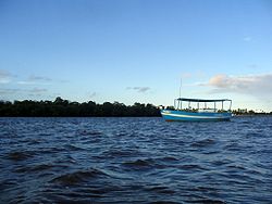
163:". It is the main river of the hydrographic basin named after him.
484:
314:
239:
152:
100:
166:
Its source is in Tromba
Mountain, between the municipalities of
280:
Its limits: in west by the São
Francisco Basin; in east by the
355:
Instituto de
Estudos Socio-ambientais do Sul da Bahia (2008).
174:,( 13°16'48 S - 41°47'02 O ) passing through the cities of
492:
159:. In Portuguese, it is sometimes erroneously called "
133:
121:
111:
93:
85:
76:
66:
61:
21:
512:
8:
519:
505:
422:: CS1 maint: location missing publisher (
334:
48:
415:
18:
7:
480:
478:
350:
348:
288:; and in North by the basins of the
194:(where the Pedras Dam was erected),
483:This article related to a river in
491:. You can help Knowledge (XXG) by
357:"Comitê da Bacia do Rio de Contas"
14:
222:, to finally to its mouth in the
47:
40:
27:
437:Brazilian Ministry of Transport
342:amplitude of its erroneous use.
408:SEI - Estado da Bahia (2002).
1:
77:Physical characteristics
410:Anuário Estatístico da Bahia
137:620 kilometres (390 mi)
123: • location
95: • location
559:
477:
107:
81:
35:
26:
461:13.505521°S 41.900193°W
323:De Contas Pequeno River
306:List of rivers of Bahia
466:-13.505521; -41.900193
317:city, by the banks of
16:River in Bahia, Brazil
457: /
234:Hydrographic basin
543:Bahia river stubs
500:
499:
363:on 9 October 2010
256:Jequiezinho River
155:state in eastern
141:
140:
550:
521:
514:
507:
479:
472:
471:
469:
468:
467:
462:
458:
455:
454:
453:
450:
428:
427:
421:
413:
405:
399:
398:
396:
394:
388:
379:
373:
372:
370:
368:
359:. Archived from
352:
343:
339:
151:) is a river of
99:Serra da Tomba,
96:
51:
50:
44:
31:
19:
558:
557:
553:
552:
551:
549:
548:
547:
538:Rivers of Bahia
528:
527:
526:
525:
475:
465:
463:
459:
456:
451:
448:
446:
444:
443:
441:
432:
431:
414:
407:
406:
402:
392:
390:
386:
381:
380:
376:
366:
364:
354:
353:
346:
340:
336:
331:
302:
294:Jequiriçá River
290:Paraguaçu River
236:
145:De Contas River
124:
94:
57:
56:
55:
54:
53:
52:
22:De Contas River
17:
12:
11:
5:
556:
554:
546:
545:
540:
530:
529:
524:
523:
516:
509:
501:
498:
497:
487:, Brazil is a
440:
439:
433:
430:
429:
400:
374:
344:
333:
332:
330:
327:
326:
325:
308:
301:
298:
282:Atlantic Ocean
235:
232:
224:Atlantic Ocean
208:Barra do Rocha
161:Rio das Contas
139:
138:
135:
131:
130:
128:Atlantic Ocean
125:
122:
119:
118:
115:
109:
108:
105:
104:
97:
91:
90:
87:
83:
82:
79:
78:
74:
73:
68:
64:
63:
59:
58:
46:
45:
39:
38:
37:
36:
33:
32:
24:
23:
15:
13:
10:
9:
6:
4:
3:
2:
555:
544:
541:
539:
536:
535:
533:
522:
517:
515:
510:
508:
503:
502:
496:
494:
490:
486:
481:
476:
473:
470:
438:
435:
434:
425:
419:
411:
404:
401:
385:
378:
375:
362:
358:
351:
349:
345:
338:
335:
328:
324:
320:
319:Brumado River
316:
312:
311:Rio de Contas
309:
307:
304:
303:
299:
297:
295:
291:
287:
283:
278:
275:
271:
269:
265:
264:Sincorá River
261:
257:
253:
252:Gongogi River
249:
248:António River
245:
244:Brumado River
241:
233:
231:
229:
225:
221:
220:Aurelino Leal
217:
213:
209:
205:
201:
197:
193:
189:
185:
181:
177:
173:
172:Rio de Contas
169:
164:
162:
158:
154:
150:
149:Rio de Contas
147:(Portuguese:
146:
136:
132:
129:
126:
120:
116:
114:
110:
106:
102:
98:
92:
88:
84:
80:
75:
72:
69:
65:
60:
43:
34:
30:
25:
20:
493:expanding it
482:
474:
442:
409:
403:
391:. Retrieved
377:
365:. Retrieved
361:the original
337:
322:
286:Minas Gerais
279:
276:
272:
268:Jacaré River
260:Gavião River
237:
165:
160:
148:
144:
142:
464: /
412:. Salvador.
389:. Fortaleza
184:Dom Basílio
532:Categories
452:41°54′01″W
449:13°30′20″S
393:13 January
367:13 January
329:References
418:cite book
321:, former
300:See also
216:Ubaitaba
180:Jussiape
62:Location
228:Itacaré
204:Itagibá
196:Jitaúna
188:Tanhaçu
67:Country
192:Jequié
157:Brazil
134:Length
117:
89:
86:Source
71:Brazil
485:Bahia
387:(PDF)
315:Bahia
240:Bahia
212:Ubatã
200:Ipiaú
176:Abíra
168:Piatã
153:Bahia
113:Mouth
103:state
101:Bahia
489:stub
424:link
395:2010
369:2010
292:and
266:and
218:and
170:and
143:The
226:in
534::
420:}}
416:{{
347:^
313:-
296:.
270:.
262:,
258:,
254:,
250:,
246:,
230:.
214:,
210:,
206:,
202:,
198:,
190:,
186:,
182:,
178:,
520:e
513:t
506:v
495:.
426:)
397:.
371:.
Text is available under the Creative Commons Attribution-ShareAlike License. Additional terms may apply.