22:
582:
91:. From Vancouver, vessels pass between Gabriola Island and Valdes Island through Gabriola Passage. Both Dodd Narrows and Gabriola Passage have strong tidal currents. Gabriola and Valdes Islands protect these smaller islands from the more open
623:
652:
616:
475:
307:
609:
302:
647:
525:
211:
165:
642:
312:
455:
99:
543:
495:
430:
147:
102:. The only access to the island is by boat or floatplane. Gulf Island Seaplanes flies to the island daily. It was also the home of
520:
266:
460:
359:
435:
500:
204:
79:. This island group runs parallel to the east coast of Vancouver Island inside the protection of the larger
589:
480:
176:
276:
197:
76:
67:) in area, gives its name to the De Courcy group of islands which consist, from north to south, of
88:
465:
415:
379:
111:
143:
107:
92:
440:
369:
225:
136:
37:
420:
344:
297:
292:
261:
80:
593:
384:
374:
349:
189:
45:
636:
510:
505:
485:
445:
399:
394:
389:
364:
317:
271:
256:
246:
171:
84:
72:
490:
470:
425:
354:
251:
221:
68:
33:
515:
106:, a mysterious cult figure in the 1920s. The island is named after Vice Admiral
103:
558:
545:
53:
21:
64:
49:
581:
41:
25:
BC Parks marker for Pirate's Cove, De Courcy Island, British
Columbia
20:
184:
60:
193:
597:
87:. Access by boat from Nanaimo in the north is through
166:
Google Maps
Satellite Image, Accessed August 7, 2006
48:
approximately 16 km (9.9 mi) southeast of
408:
337:
330:
285:
239:
232:
135:
52:and approximately 38 km (24 mi) west of
16:Island off the coast of British Columbia, Canada
617:
205:
8:
142:(3rd, 1997 ed.), Vancouver: UBC Press,
624:
610:
334:
236:
212:
198:
190:
134:Akrigg, G.P.V.; Akrigg, Helen B. (1986),
126:
653:British Columbia Coast geography stubs
588:This article about a location on the
7:
578:
576:
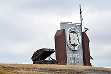
100:Pirates Cove Marine Provincial Park
44:, located between the Pylades and
14:
71:, Link Island, De Courcy Island,
580:
1:
185:http://www.decourcyisland.com
36:of the coast of southwestern
648:Regional District of Nanaimo
596:. You can help Knowledge by
138:British Columbia Place Names
98:De Courcy Island is home to
643:Islands of the Gulf Islands
669:
575:
590:Coast of British Columbia
365:North and South Pender
59:The island, about 460
26:
331:Southern Gulf Islands
233:Northern Gulf Islands
177:BC Geographical Names
24:
555: /
559:49.100°N 123.750°W
416:Belle Chain Islets
293:Ahgykson (Harwood)
172:"De Courcy Island"
27:
605:
604:
538:
537:
534:
533:
326:
325:
277:Thormanby Islands
108:Michael de Courcy
93:Strait of Georgia
660:
626:
619:
612:
584:
577:
570:
569:
567:
566:
565:
564:49.100; -123.750
560:
556:
553:
552:
551:
548:
335:
237:
226:British Columbia
214:
207:
200:
191:
181:
153:
152:
141:
131:
38:British Columbia
30:De Courcy Island
668:
667:
663:
662:
661:
659:
658:
657:
633:
632:
631:
630:
573:
563:
561:
557:
554:
549:
546:
544:
542:
541:
539:
530:
481:North Secretary
431:Chatham Islands
404:
322:
281:
228:
218:
170:
162:
157:
156:
150:
133:
132:
128:
123:
81:Gabriola Island
46:Stuart Channels
17:
12:
11:
5:
666:
664:
656:
655:
650:
645:
635:
634:
629:
628:
621:
614:
606:
603:
602:
592:, Canada is a
585:
536:
535:
532:
531:
529:
528:
523:
518:
513:
508:
503:
498:
493:
488:
483:
478:
473:
468:
463:
458:
453:
448:
443:
438:
433:
428:
423:
418:
412:
410:
406:
405:
403:
402:
397:
392:
387:
382:
377:
372:
367:
362:
357:
352:
347:
341:
339:
332:
328:
327:
324:
323:
321:
320:
315:
310:
305:
300:
295:
289:
287:
283:
282:
280:
279:
274:
269:
264:
259:
254:
249:
243:
241:
234:
230:
229:
219:
217:
216:
209:
202:
194:
188:
187:
182:
168:
161:
160:External links
158:
155:
154:
148:
125:
124:
122:
119:
77:Pylades Island
32:is one of the
15:
13:
10:
9:
6:
4:
3:
2:
665:
654:
651:
649:
646:
644:
641:
640:
638:
627:
622:
620:
615:
613:
608:
607:
601:
599:
595:
591:
586:
583:
579:
574:
571:
568:
527:
524:
522:
521:Trial Islands
519:
517:
514:
512:
509:
507:
504:
502:
499:
497:
494:
492:
489:
487:
484:
482:
479:
477:
474:
472:
469:
467:
464:
462:
459:
457:
454:
452:
449:
447:
444:
442:
439:
437:
434:
432:
429:
427:
424:
422:
419:
417:
414:
413:
411:
407:
401:
398:
396:
393:
391:
388:
386:
383:
381:
378:
376:
373:
371:
368:
366:
363:
361:
358:
356:
353:
351:
348:
346:
343:
342:
340:
336:
333:
329:
319:
316:
314:
311:
309:
306:
304:
301:
299:
296:
294:
291:
290:
288:
284:
278:
275:
273:
270:
268:
265:
263:
260:
258:
255:
253:
250:
248:
245:
244:
242:
238:
235:
231:
227:
223:
215:
210:
208:
203:
201:
196:
195:
192:
186:
183:
179:
178:
173:
169:
167:
164:
163:
159:
151:
149:0-7748-0636-2
145:
140:
139:
130:
127:
120:
118:
116:
115:
110:, captain of
109:
105:
101:
96:
94:
90:
86:
85:Valdes Island
82:
78:
74:
73:Ruxton Island
70:
66:
62:
57:
55:
51:
47:
43:
39:
35:
31:
23:
19:
598:expanding it
587:
572:
540:
450:
426:Chain Islets
222:Gulf Islands
175:
137:
129:
113:
97:
89:Dodd Narrows
69:Mudge Island
63:(186.2
58:
34:Gulf Islands
29:
28:
18:
562: /
466:Jemmy Jones
380:Salt Spring
104:Brother XII
637:Categories
501:Protection
308:Mitlenatch
121:References
476:Newcastle
456:Discovery
451:De Courcy
370:Penelakut
54:Vancouver
550:123°45′W
496:Portland
421:Brethour
345:Gabriola
303:Jedediah
298:Hernando
262:Lasqueti
547:49°06′N
526:Wallace
385:Saturna
375:Prevost
360:Moresby
350:Galiano
114:Pylades
50:Nanaimo
511:Samuel
506:Ruxton
486:Parker
446:Dayman
441:D'Arcy
436:Curlew
400:Valdes
395:Thetis
390:Sidney
318:Savary
313:Musket
272:Texada
267:Nelson
257:Hornby
247:Denman
146:
42:Canada
516:Skull
491:Piers
471:Mudge
461:James
409:Minor
355:Mayne
338:Major
286:Minor
252:Hardy
240:Major
61:acres
594:stub
220:The
144:ISBN
112:HMS
83:and
75:and
224:of
639::
174:.
117:.
95:.
65:ha
56:.
40:,
625:e
618:t
611:v
600:.
213:e
206:t
199:v
180:.
Text is available under the Creative Commons Attribution-ShareAlike License. Additional terms may apply.