646:
500:
59:
89:
42:
96:
66:
299:
Defeated is named for the events that took place in the late 18th century along the banks of
Defeated Creek. John Peyton, one of the earliest settlers and explorers of Smith County, and his surveying party were camped along the creek when they were attacked by a band of
322:
Defeated is home to the
Defeated Creek Marina, which lies along the Defeated Creek section of Cordell Hull Lake. The marina is home to a boat dock and ramp, rental cabins, and numerous recreational facilities.
706:
428:
711:
687:
716:
357:
281:
121:
88:
372:
58:
421:
680:
538:
348:
253:
414:
673:
353:
41:
406:
175:
645:
588:
543:
489:
616:
583:
558:
293:
269:
241:
153:
32:
343:
653:
510:
484:
438:
273:
180:
603:
623:
593:
578:
573:
553:
214:
528:
479:
460:
277:
563:
518:
385:
568:
289:
204:
657:
285:
598:
700:
246:
288:(the lower part of the creek and the adjacent section of the river are both part of
453:
312:
305:
163:
136:
123:
195:
168:
301:
229:
397:
221:
200:
471:
410:
319:
from 1824 through 1880, when the name was changed to
Defeated.
498:
388:, Smith County Genealogy website, accessed December 22, 2009
661:
707:
Unincorporated communities in Smith County, Tennessee
18:
Unincorporated community in
Tennessee, United States
527:
509:
470:
315:from 1824 until 1929. The post office had the name
252:
240:
228:
211:
194:
186:
174:
162:
152:
23:
386:Post Offices and Post Masters for Smith County
681:
422:
8:
276:, United States. It is located northeast of
400:. Official website. Accessed: 7 April 2017.
95:
65:
688:
674:
429:
415:
407:
20:
376:(Brandon Printing Company, 1909), p. 120.
358:United States Department of the Interior
712:Unincorporated communities in Tennessee
332:
251:
227:
193:
185:
151:
116:
50:
38:
338:
336:
239:
210:
173:
161:
7:
642:
640:
349:Geographic Names Information System
660:. You can help Knowledge (XXG) by
437:Municipalities and communities of
14:
373:Early History of Middle Tennessee
717:Middle Tennessee geography stubs
644:
94:
87:
64:
57:
46:Buildings and houses in Defeated
40:
656:geography–related article is a
354:United States Geological Survey
296:passes through the community.
1:
108:Show map of the United States
308:and driven out of the area.
311:Defeated was the site of a
733:
639:
612:
496:
451:
117:
51:
39:
30:
270:unincorporated community
190:551 ft (168 m)
33:Unincorporated community
654:Smith County, Tennessee
440:Smith County, Tennessee
274:Smith County, Tennessee
503:
502:
398:Defeated Creek Marina
344:"Defeated, Tennessee"
284:, a tributary of the
213: • Summer (
137:36.32639°N 85.90833°W
78:Show map of Tennessee
625:United States portal
142:36.32639; -85.90833
133: /
102:Defeated, Tennessee
72:Defeated, Tennessee
25:Defeated, Tennessee
504:
669:
668:
634:
633:
370:Edward Albright,
290:Cordell Hull Lake
263:
262:
724:
690:
683:
676:
648:
641:
626:
619:
618:Tennessee portal
501:
463:
456:
446:
441:
431:
424:
417:
408:
401:
395:
389:
383:
377:
368:
362:
361:
340:
286:Cumberland River
218:
148:
147:
145:
144:
143:
138:
134:
131:
130:
129:
126:
109:
98:
97:
91:
79:
68:
67:
61:
44:
21:
732:
731:
727:
726:
725:
723:
722:
721:
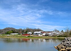
697:
696:
695:
694:
637:
635:
630:
624:
617:
608:
530:
523:
505:
499:
494:
466:
461:
454:
447:
444:
439:
435:
405:
404:
396:
392:
384:
380:
369:
365:
342:
341:
334:
329:
236:
212:
141:
139:
135:
132:
127:
124:
122:
120:
119:
113:
112:
111:
110:
107:
106:
105:
104:
103:
99:
82:
81:
80:
77:
76:
75:
74:
73:
69:
47:
35:
26:
19:
12:
11:
5:
730:
728:
720:
719:
714:
709:
699:
698:
693:
692:
685:
678:
670:
667:
666:
649:
632:
631:
629:
628:
621:
613:
610:
609:
607:
606:
601:
596:
591:
589:Pleasant Shade
586:
581:
576:
571:
566:
561:
556:
551:
546:
544:Chestnut Mound
541:
535:
533:
525:
524:
522:
521:
515:
513:
507:
506:
497:
495:
493:
492:
490:South Carthage
487:
482:
476:
474:
468:
467:
452:
449:
448:
436:
434:
433:
426:
419:
411:
403:
402:
390:
378:
363:
331:
330:
328:
325:
294:State Route 85
282:Defeated Creek
261:
260:
257:
250:
249:
244:
238:
237:
234:
232:
226:
225:
219:
209:
208:
198:
192:
191:
188:
184:
183:
178:
172:
171:
166:
160:
159:
156:
150:
149:
115:
114:
101:
100:
93:
92:
86:
85:
84:
83:
71:
70:
63:
62:
56:
55:
54:
53:
52:
49:
48:
45:
37:
36:
31:
28:
27:
24:
17:
13:
10:
9:
6:
4:
3:
2:
729:
718:
715:
713:
710:
708:
705:
704:
702:
691:
686:
684:
679:
677:
672:
671:
665:
663:
659:
655:
650:
647:
643:
638:
627:
622:
620:
615:
614:
611:
605:
602:
600:
597:
595:
592:
590:
587:
585:
584:New Middleton
582:
580:
577:
575:
572:
570:
567:
565:
562:
560:
559:Dixon Springs
557:
555:
552:
550:
547:
545:
542:
540:
537:
536:
534:
532:
526:
520:
517:
516:
514:
512:
508:
491:
488:
486:
483:
481:
478:
477:
475:
473:
469:
465:
464:
457:
450:
445:United States
442:
432:
427:
425:
420:
418:
413:
412:
409:
399:
394:
391:
387:
382:
379:
375:
374:
367:
364:
359:
355:
351:
350:
345:
339:
337:
333:
326:
324:
320:
318:
314:
309:
307:
303:
297:
295:
291:
287:
283:
279:
275:
271:
267:
258:
255:
248:
245:
243:
233:
231:
223:
220:
216:
206:
205:Central (CST)
202:
199:
197:
189:
182:
179:
177:
170:
167:
165:
158:United States
157:
155:
146:
118:Coordinates:
90:
60:
43:
34:
29:
22:
16:
662:expanding it
651:
636:
548:
485:Gordonsville
459:
393:
381:
371:
366:
347:
321:
316:
310:
298:
265:
264:
15:
539:Brush Creek
531:communities
455:County seat
313:post office
306:Hanging Maw
140: /
701:Categories
327:References
256:feature ID
128:85°54′30″W
125:36°19′35″N
604:Stonewall
594:Riddleton
579:Lancaster
574:Kempville
554:Difficult
302:Cherokees
242:Area code
196:Time zone
187:Elevation
169:Tennessee
549:Defeated
480:Carthage
462:Carthage
317:Montrose
278:Carthage
266:Defeated
230:ZIP code
564:Elmwood
519:Hickman
304:led by
259:1306322
154:Country
569:Enigma
280:along
268:is an
176:County
652:This
529:Other
472:Towns
235:37030
224:(CDT)
222:UTC-5
201:UTC-6
181:Smith
164:State
658:stub
599:Rome
292:).
254:GNIS
511:CDP
272:in
247:615
215:DST
703::
458::
443:,
356:,
352:.
346:.
335:^
689:e
682:t
675:v
664:.
430:e
423:t
416:v
360:.
217:)
207:)
203:(
Text is available under the Creative Commons Attribution-ShareAlike License. Additional terms may apply.