248:, at an altitude of 2,400 m in northern Pirin. It initially flows to the west and at the Tiyatsite locality it turns northwards. It flows at an average gradient of 102 m/km, forming numerous jumps and waterfalls. Near the Demyanitsa refuge the Demyanitsa takes two tributaries, the Vasilashka Reka (left) and the Gazeyska Reka (right), followed by two more tributaries further downstream, the Karkamska Reka (left) and the Yulen (right). The numerous tributaries make the river relatively abounding in water for its size, with average discharge of 1.5 m/s. At 1.5 km from the Demyanitsa refuge it forms the Demyanishki Skok waterfall (11 m) at altitude of 1,750 m; at 1,650 m it forms another waterfall, the Yulenski Skok (9 m). Both waterfalls were declared natural landmarks in 1965. At 400 m southwest of the town of
29:
291:
309:
318:
300:
402:Мичев (Michev), Николай (Nikolay); Михайлов (Mihaylov), Цветко (Tsvetko); Вапцаров (Vaptsarov), Иван (Ivan); Кираджиев (Kiradzhiev), Светлин (Svetlin) (1980).
127:
446:
441:
276:
28:
214:
245:
73:
264:
290:
268:
451:
272:
260:
234:
201:
308:
263:
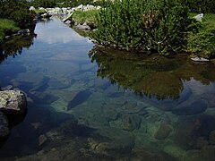
covers a territory of 37 km and includes six glacial lake groups in Pirin —
435:
230:
197:
237:. The river is 13.6 km long and drains parts of the northeastern slopes of the
98:
317:
299:
253:
241:
mountain range. It is sometimes considered as the main branch of the Glazne.
142:
129:
222:
44:
410:] (in Bulgarian). София (Sofia): Наука и култура (Nauka i kultura).
369:
367:
337:
335:
252:
at an altitude of 1,063 m, the
Demyanitsa merges with the river
249:
226:
193:
113:
424:
238:
77:
373:
341:
189:
184:
176:
168:
158:
119:
107:
97:
83:
67:
59:
50:
40:
35:
21:
279:. Its valley is covered with coniferous forests.
8:
354:
352:
350:
415:Душков (Dushkov), Добри (Dobri) (1972).
233:, itself a right tributary of the river
385:
358:
331:
286:
374:Geographic Dictionary of Bulgaria 1980
342:Geographic Dictionary of Bulgaria 1980
18:
427:): Наука и култура (Nauka i kultura).
7:
244:The river takes its source from the
14:
447:Landforms of Blagoevgrad Province
408:Geographic Dictionary of Bulgaria
316:
307:
298:
289:
27:
180:37 km (14 sq mi)
16:River in south-western Bulgaria
221:) is a river in south-western
121: • coordinates
1:
423:] (in Bulgarian). София (
404:Географски речник на България
51:Physical characteristics
256:, forming the river Glazne.
164:1,063 m (3,488 ft)
160: • elevation
89:2,400 m (7,900 ft)
85: • elevation
225:, a right tributary of the
109: • location
69: • location
468:
417:Пирин. Туристически речник
172:13.6 km (8.5 mi)
421:Pirin. Tourist Dictionary
218:
143:41.8168972°N 23.4706000°E
93:
55:
26:
229:, which flows into the
148:41.8168972; 23.4706000
376:, pp. 165, 554
185:Basin features
139: /
442:Rivers of Bulgaria
246:Valyavishki Lakes
207:
206:
74:Valyavishki Lakes
459:
428:
411:
389:
383:
377:
371:
362:
361:, pp. 63–64
356:
345:
339:
320:
311:
302:
293:
275:, Karkamski and
220:
154:
153:
151:
150:
149:
144:
140:
137:
136:
135:
132:
86:
70:
31:
19:
467:
466:
462:
461:
460:
458:
457:
456:
432:
431:
414:
401:
398:
393:
392:
384:
380:
372:
365:
357:
348:
340:
333:
328:
321:
312:
303:
294:
285:
267:, Valyavishki,
161:
147:
145:
141:
138:
133:
130:
128:
126:
125:
122:
110:
84:
68:
17:
12:
11:
5:
465:
463:
455:
454:
449:
444:
434:
433:
430:
429:
412:
397:
394:
391:
390:
378:
363:
346:
330:
329:
327:
324:
323:
322:
315:
313:
306:
304:
297:
295:
288:
284:
281:
261:drainage basin
205:
204:
191:
187:
186:
182:
181:
178:
174:
173:
170:
166:
165:
162:
159:
156:
155:
123:
120:
117:
116:
111:
108:
105:
104:
101:
95:
94:
91:
90:
87:
81:
80:
71:
65:
64:
61:
57:
56:
53:
52:
48:
47:
42:
38:
37:
33:
32:
24:
23:
15:
13:
10:
9:
6:
4:
3:
2:
464:
453:
450:
448:
445:
443:
440:
439:
437:
426:
422:
418:
413:
409:
405:
400:
399:
395:
387:
382:
379:
375:
370:
368:
364:
360:
355:
353:
351:
347:
344:, p. 137
343:
338:
336:
332:
325:
319:
314:
310:
305:
301:
296:
292:
287:
282:
280:
278:
274:
270:
266:
262:
257:
255:
251:
247:
242:
240:
236:
232:
228:
224:
216:
212:
203:
199:
195:
192:
188:
183:
179:
175:
171:
167:
163:
157:
152:
134:23°28′14.16″E
124:
118:
115:
112:
106:
102:
100:
96:
92:
88:
82:
79:
75:
72:
66:
62:
58:
54:
49:
46:
43:
39:
34:
30:
25:
20:
420:
416:
407:
403:
388:, p. 36
386:Dushkov 1972
381:
359:Dushkov 1972
258:
243:
210:
208:
131:41°49′0.83″N
190:Progression
146: /
436:Categories
396:References
265:Vasilashki
254:Banderitsa
211:Demyanitsa
177:Basin size
22:Demyanitsa
326:Citations
269:Prevalski
215:Bulgarian
277:Gazeyski
273:Tipitski
223:Bulgaria
219:Демяница
45:Bulgaria
36:Location
283:Gallery
41:Country
250:Bansko
227:Glazne
194:Glazne
169:Length
114:Glazne
103:
63:
60:Source
452:Pirin
425:Sofia
419:[
406:[
239:Pirin
235:Mesta
231:Iztok
202:Mesta
198:Iztok
99:Mouth
78:Pirin
259:Its
209:The
438::
366:^
349:^
334:^
271:,
217::
200:→
196:→
76:,
213:(
Text is available under the Creative Commons Attribution-ShareAlike License. Additional terms may apply.