794:
31:
236:
266:, the narces of La Sauvetat, and the Limagne marsh. The others are called "gardes." There are about 150 of them, forming either a chain of small forest-covered hills along a north–south axis or appearing as features in the middle of fields. Most have been cultivated at their base, leaving a forest cover (
382:
The Devès massif is characterized by a balanced landscape of grassland and cultivated systems. Its forest cover rate of 22% is lower than the average for the Massif
Central due to the clearing of ancient forests over the past 150 years. The area has the highest number of plant species in the
365:
provide a sheltered position leading to reduced precipitation (about 850 mm/year on average). In winter, snow remains on the ground for several months, and the forests and pastures are swept by the
690:
659:
714:"Végétations et successions végétales dans les monts du Devès (Haute-Loire, France) : esquisse phytosociologique et symphytosociologique d'un secteur volcanique méconnu"
598:
232:
are dated to 6 million years ago, but most of the volcanic activity occurred between 3.5 and 0.6 million years ago, with two peaks at 1 and 2 million years ago.
682:
651:
771:
815:
561:"Les Narces de la Sauvetat - Landos - Département 43 : Culture, sports et loisirs, économie et tourisme en Haute Loire - Conseil général 43"
66:
628:
568:
532:
469:
433:
741:
153:
499:
439:
524:
Le Lac du
Bouchet (I): environnement naturel et étude des sédiments du dernier cycle climatique : depuis 120000 ans B.P.
538:
590:
59:
825:
229:
820:
763:
106:
206:
262:
occupied by spontaneous vegetation adapted to wet environments. The most emblematic of the plateau are
259:
251:
620:
395:
222:
560:
461:
733:
713:
528:
429:
401:
385:
799:
725:
358:
169:
217:
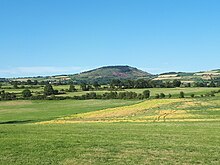
The Devès massif, which is more of a high plateau, is one of the three volcanic massifs of
141:
491:
263:
186:
145:
121:
114:
809:
279:
157:
52:
172:
term that refers to a "forbidden forest, protected," meaning it is not exploited.
764:"Les trachéophytes du Devès - Conservatoire botanique national du Massif central"
522:
423:
383:
department, with particularly rich flora and the presence of rare plants such as
247:
149:
621:"Les végétations du Devès - Conservatoire botanique national du Massif central"
789:
303:
737:
462:"Le territoire du Devès - Conservatoire botanique national du Massif central"
81:
68:
362:
194:
190:
729:
30:
235:
371:
254:
origin. Some of these cones still retain their craters, similar to some
652:"Météo - Notre vidéo de la burle et des congères au sud du département"
137:
240:
198:
134:
46:
683:"Météo - La burle et les congères formées en Haute-Loire en vidéos"
591:"Découvrez le patrimoine local de Siaugues Sainte Marie dans le 43"
712:
Meinard, Yves; Thébaud, Gilles; Roux, Camille (14 December 2022).
367:
234:
228:
It is the largest basalt plateau in the Massif
Central. The first
218:
202:
718:
BIOM - Revue scientifique pour la biodiversité du Massif central
267:
255:
282:, highest point of the massif at 1,421 m (4,662 ft)
492:"Géologie | Conservatoire d'espaces naturels d'Auvergne"
345:
La Garde des
Ceyssoux, 1,064 m (3,491 ft)
113:
102:
97:
58:
45:
40:
23:
342:La Garde de Tallobre, 1,069 m (3,507 ft)
315:Rocher de la Fagette, 1,265 m (4,150 ft)
405:, which are critically endangered in Auvergne.
185:The Devès is bordered to the west by the upper
339:Suc de Miceselle, 1,115 m (3,658 ft)
294:Rang de la Garde, 1,326 m (4,350 ft)
8:
357:The climate is cold but relatively dry; the
327:Suc de Combret, 1,232 m (4,042 ft)
428:(in French). Librairie Droz. p. 1489.
348:Mont Briançon, 1,045 m (3,428 ft)
246:The surface of the plateau is covered with
35:Location map of Devès in the Massif Central
309:Mont Maillon, 1,291 m (4,236 ft)
297:Champ Vestri, 1,321 m (4,334 ft)
291:Mont Farnier, 1,328 m (4,357 ft)
285:Mont Recours, 1,382 m (4,534 ft)
20:
330:Côte Rousse, 1,218 m (3,996 ft)
312:La Vesseyre, 1,279 m (4,196 ft)
288:Mont Tartas, 1,349 m (4,426 ft)
324:Mont Burel, 1,227 m (4,026 ft)
321:Montpignon, 1,230 m (4,040 ft)
414:
333:Le Pouzat, 1,208 m (3,963 ft)
318:Montchaud, 1,243 m (4,078 ft)
300:Mont Long, 1,317 m (4,321 ft)
601:from the original on 19 February 2024
336:Montjus, 1,122 m (3,681 ft)
270:) at their summit or rocky outcrops.
201:massif, and to the east by the upper
7:
502:from the original on 29 January 2024
197:mountains, to the northeast by the
774:from the original on 23 March 2023
662:from the original on 23 March 2023
631:from the original on 23 March 2023
472:from the original on 22 April 2024
156:. It reaches its highest point at
14:
744:from the original on 1 March 2024
527:(in French). CERLAT. p. 66.
792:
693:from the original on 20 May 2024
571:from the original on 20 May 2024
541:from the original on 22 May 2024
442:from the original on 15 May 2015
160:at an altitude of 1,421 meters.
51:1,421 m (4,662 ft) at
29:
816:Subranges of the Massif Central
681:France, Centre (1 March 2018).
650:France, Centre (1 March 2018).
595:www.mairie-siaugues-stemarie.fr
425:Toponymie générale de la France
193:mountains, to the north by the
306:, 1,299 m (4,262 ft)
1:
842:
370:," the local name for the
221:, the other two being the
16:Volcanic plateau in France
28:
521:Bonifay, Eugène (1991).
154:natural region of France
730:10.52497/biom.v3i1.318
422:Nègre, Ernest (1998).
243:
238:
107:Auvergne-Rhône-Alpes
82:44.94028°N 3.76528°E
396:Camelina microcarpa
258:craters, which are
78: /
826:Plateaus of Europe
244:
207:Vivarais mountains
41:Highest point
821:Volcanic plateaus
687:www.lamontagne.fr
565:www.hauteloire.fr
534:978-2-9505851-0-3
435:978-2-600-02884-4
402:Ranunculus lingua
386:Neslia paniculata
127:
126:
87:44.94028; 3.76528
833:
802:
800:Mountains portal
797:
796:
795:
784:
783:
781:
779:
768:projets.cbnmc.fr
760:
754:
753:
751:
749:
709:
703:
702:
700:
698:
678:
672:
671:
669:
667:
647:
641:
640:
638:
636:
625:projets.cbnmc.fr
617:
611:
610:
608:
606:
587:
581:
580:
578:
576:
557:
551:
550:
548:
546:
518:
512:
511:
509:
507:
488:
482:
481:
479:
477:
466:projets.cbnmc.fr
458:
452:
451:
449:
447:
419:
359:Mounts of Cantal
225:and the Meygal.
117:
93:
92:
90:
89:
88:
83:
79:
76:
75:
74:
71:
33:
21:
841:
840:
836:
835:
834:
832:
831:
830:
806:
805:
798:
793:
791:
788:
787:
777:
775:
762:
761:
757:
747:
745:
711:
710:
706:
696:
694:
680:
679:
675:
665:
663:
649:
648:
644:
634:
632:
619:
618:
614:
604:
602:
589:
588:
584:
574:
572:
559:
558:
554:
544:
542:
535:
520:
519:
515:
505:
503:
496:cen-auvergne.fr
490:
489:
485:
475:
473:
460:
459:
455:
445:
443:
436:
421:
420:
416:
411:
380:
378:Fauna and flora
355:
276:
215:
205:valley and the
189:valley and the
183:
178:
166:
142:Velay mountains
115:
86:
84:
80:
77:
72:
69:
67:
65:
64:
36:
17:
12:
11:
5:
839:
837:
829:
828:
823:
818:
808:
807:
804:
803:
786:
785:
755:
704:
673:
642:
612:
582:
552:
533:
513:
483:
453:
434:
413:
412:
410:
407:
379:
376:
354:
351:
350:
349:
346:
343:
340:
337:
334:
331:
328:
325:
322:
319:
316:
313:
310:
307:
301:
298:
295:
292:
289:
286:
283:
275:
272:
264:Lac du Bouchet
214:
211:
182:
179:
177:
174:
165:
162:
146:Massif Central
125:
124:
122:Massif Central
119:
111:
110:
104:
100:
99:
95:
94:
62:
56:
55:
49:
43:
42:
38:
37:
34:
26:
25:
15:
13:
10:
9:
6:
4:
3:
2:
838:
827:
824:
822:
819:
817:
814:
813:
811:
801:
790:
773:
769:
765:
759:
756:
743:
739:
735:
731:
727:
724:(1): 82–102.
723:
720:(in French).
719:
715:
708:
705:
692:
688:
684:
677:
674:
661:
657:
656:www.leveil.fr
653:
646:
643:
630:
626:
622:
616:
613:
600:
597:(in French).
596:
592:
586:
583:
570:
566:
562:
556:
553:
540:
536:
530:
526:
525:
517:
514:
501:
498:(in French).
497:
493:
487:
484:
471:
467:
463:
457:
454:
441:
437:
431:
427:
426:
418:
415:
408:
406:
404:
403:
398:
397:
392:
388:
387:
377:
375:
373:
369:
364:
360:
352:
347:
344:
341:
338:
335:
332:
329:
326:
323:
320:
317:
314:
311:
308:
305:
302:
299:
296:
293:
290:
287:
284:
281:
278:
277:
273:
271:
269:
265:
261:
257:
253:
249:
242:
239:The Garde of
237:
233:
231:
226:
224:
223:Mézenc massif
220:
212:
210:
208:
204:
200:
196:
192:
188:
180:
175:
173:
171:
163:
161:
159:
155:
151:
148:, located in
147:
143:
139:
136:
132:
123:
120:
118:
112:
108:
105:
101:
96:
91:
63:
61:
57:
54:
50:
48:
44:
39:
32:
27:
22:
19:
776:. Retrieved
767:
758:
746:. Retrieved
721:
717:
707:
695:. Retrieved
686:
676:
664:. Retrieved
655:
645:
633:. Retrieved
624:
615:
603:. Retrieved
594:
585:
573:. Retrieved
564:
555:
543:. Retrieved
523:
516:
504:. Retrieved
495:
486:
474:. Retrieved
465:
456:
444:. Retrieved
424:
417:
400:
394:
390:
384:
381:
356:
274:Main summits
248:scoria cones
245:
227:
216:
184:
168:Devès is an
167:
152:, forming a
130:
128:
116:Parent range
18:
260:depressions
252:Strombolian
150:Haute-Loire
85: /
60:Coordinates
810:Categories
409:References
304:La Durande
280:Mont Devès
158:Mont Devès
133:is a vast
70:44°56′25″N
53:Mont Devès
738:2727-8131
363:Margeride
230:eruptions
195:Livradois
191:Margeride
176:Geography
98:Geography
73:3°45′55″E
47:Elevation
772:Archived
742:Archived
691:Archived
660:Archived
629:Archived
599:Archived
569:Archived
539:Archived
500:Archived
470:Archived
440:Archived
391:thracica
372:blizzard
181:Location
164:Toponomy
109:, France
103:Location
389:subsp.
353:Climate
213:Geology
170:Occitan
144:of the
140:in the
138:plateau
778:20 May
748:20 May
736:
697:20 May
666:20 May
635:20 May
605:20 May
575:20 May
545:20 May
531:
506:20 May
476:20 May
446:20 May
432:
399:, and
241:Rauret
199:Meygal
187:Allier
135:basalt
368:burle
268:pines
219:Velay
203:Loire
131:Devès
24:Devès
780:2024
750:2024
734:ISSN
699:2024
668:2024
637:2024
607:2024
577:2024
547:2024
529:ISBN
508:2024
478:2024
448:2024
430:ISBN
361:and
256:maar
129:The
726:doi
250:of
812::
770:.
766:.
740:.
732:.
716:.
689:.
685:.
658:.
654:.
627:.
623:.
593:.
567:.
563:.
537:.
494:.
468:.
464:.
438:.
393:,
374:.
209:.
782:.
752:.
728::
722:3
701:.
670:.
639:.
609:.
579:.
549:.
510:.
480:.
450:.
366:"
Text is available under the Creative Commons Attribution-ShareAlike License. Additional terms may apply.