29:
272:
161:
Average discharge at this place is 4 m.s. Because of daily flows variability and strong influence of flood events on average values, this quantity is very representative of what is commonly observed in streams. We, therefore, prefer the term median flow to characterize the normal flow of
276:
195:
The small size of
Caledonian watershed gives them a very important responsiveness to hazards. Concentration time that reflects duration between the maximum rain episode with the corresponding maximum throughput is only 4:25 for
298:
218:
159:
has been monitored during a 43-year period between 1955 and 2008. The mouth is very influenced by tide so discharge is measured at Bondé Sainte Anne. At this place the basin area is 248 km.
139:. It carries a substantial load of fine-grained sediment, which has increased over time due to felling and burning of forest and woodland vegetation and the introduction of grazing, creating
305:
203:
Values of low water can be very little with a median "low water characteristic discharge" 0.59 m.s and
Centennial dry "low water characteristic discharge" 0.2 m.s.
177:
Low water occur during the dry season (July to
November) in summer (July to September), resulting in a decrease in average monthly flow to 1.1 m.s in September.
181:
watershed receives an average annual water blade precipitated of 1097mm while the runoff depth is 796mm. The interannual mean runoff coefficient is 50%.
174:
has seasonal flow variations strongly marked with floods during the wet season (December–April) and a large peak of 11 m.s in March.
328:
367:
115:, flowing for some 60 miles (100 kilometres). It has a catchment area of 620 square kilometres and opens north-westward into the
193:
The maximum flood was observed during the tropical depression on
February 6, 1972. Its flow was then measured at 3720 m.s.
248:
191:
The hundred-year flood is between 3375 m.s and 5400 m.s according to the assessments of flood maxima observed.
116:
132:
127:
lies on the river, not far from the mouth. The Diahot flows into the sea between the villages of
244:
164:
Median daily flow characterizes the flow value exceeded on average one day on two. Its value on
136:
128:
119:, flowing towards the northern point of the island along the western escarpment of the
361:
120:
112:
74:
47:
140:
59:
343:
330:
189:
The annual flood discharge rises to 500 m.s and 10-year flood to 1906 m.s.
124:
28:
299:"Recueil des débits caractéristiques de la Nouvelle-Calédonie"
220:
Recueil des débits caractéristiques de la
Nouvelle-Calédonie
92:
84:
68:
58:
53:
43:
38:
21:
273:"The impacts of opencast mining in New Caledonia"
275:. The United Nations University. Archived from
8:
233:
18:
267:
265:
7:
239:
237:
98:4 m/s (140 cu ft/s)
14:
27:
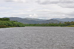
33:Diahot river downstream Ouégoa
1:
54:Physical characteristics
70: • location
384:
94: • average
102:
80:
26:
111:is the longest river of
368:Rivers of New Caledonia
249:Encyclopædia Britannica
152:General characteristics
344:20.32444°S 164.32778°E
16:River in New Caledonia
223:, DAVAR, Nouméa, 2009
143:in the river system.
349:-20.32444; 164.32778
340: /
123:. The village of
106:
105:
375:
355:
354:
352:
351:
350:
345:
341:
338:
337:
336:
333:
320:
319:
317:
316:
310:
304:. Archived from
303:
295:
289:
288:
286:
284:
269:
260:
259:
257:
255:
241:
135:, just south of
95:
31:
19:
383:
382:
378:
377:
376:
374:
373:
372:
358:
357:
348:
346:
342:
339:
334:
331:
329:
327:
326:
324:
323:
314:
312:
308:
301:
297:
296:
292:
282:
280:
279:on 27 July 2011
271:
270:
263:
253:
251:
243:
242:
235:
230:
214:
209:
194:
192:
190:
187:
163:
160:
154:
149:
117:Baie d'Harcourt
93:
71:
34:
17:
12:
11:
5:
381:
379:
371:
370:
360:
359:
322:
321:
290:
261:
245:"Diahot River"
232:
231:
229:
226:
225:
224:
217:Renaud ALRIC,
213:
210:
208:
205:
186:
185:Extreme Values
183:
153:
150:
148:
145:
104:
103:
100:
99:
96:
90:
89:
86:
82:
81:
78:
77:
72:
69:
66:
65:
62:
56:
55:
51:
50:
45:
41:
40:
36:
35:
32:
24:
23:
15:
13:
10:
9:
6:
4:
3:
2:
380:
369:
366:
365:
363:
356:
353:
311:on 2012-10-30
307:
300:
294:
291:
278:
274:
268:
266:
262:
250:
246:
240:
238:
234:
227:
222:
221:
216:
215:
211:
206:
204:
201:
199:
184:
182:
180:
175:
173:
169:
167:
162:watercourses.
158:
151:
146:
144:
142:
138:
134:
130:
126:
122:
118:
114:
113:New Caledonia
110:
101:
97:
91:
87:
83:
79:
76:
75:Pacific Ocean
73:
67:
63:
61:
57:
52:
49:
48:New Caledonia
46:
42:
37:
30:
25:
20:
325:
313:. Retrieved
306:the original
293:
281:. Retrieved
277:the original
252:. Retrieved
219:
212:Bibliography
202:
197:
188:
178:
176:
171:
170:
168:is 2,3 m.s.
165:
156:
155:
141:soil erosion
108:
107:
22:Diahot River
347: /
335:164°19′40″E
332:20°19′28″S
315:2013-03-30
228:References
137:Ile de Pam
121:Mont Panié
147:Hydrology
85:Discharge
362:Category
129:Bwalayet
39:Location
207:Annexes
44:Country
283:9 June
254:9 June
198:Diahot
179:Diahot
172:Diahot
166:Diahot
157:Diahot
125:Ouégoa
109:Diahot
88:
64:
309:(PDF)
302:(PDF)
60:Mouth
285:2011
256:2011
131:and
133:Pam
364::
264:^
247:.
236:^
200:.
318:.
287:.
258:.
Text is available under the Creative Commons Attribution-ShareAlike License. Additional terms may apply.