45:
29:
304:
Many places on the banks of the river draw their names from it. On the river's upper reaches these are
Offdilln, Dillbrecht, Fellerdilln, Dillenburg, and further downstream Dillheim. Dillenburg was the seat of the former
389:
384:
379:
419:
404:
143:
424:
414:
409:
361:
Water map service of the
Hessian Ministry for the Environment, Energy, Agriculture and Consumer Protection (
310:
306:
290:
258:
330:
274:
89:
398:
326:
322:
281:
meet. During its course, roughly from north to south, the Dill passes the towns of
44:
363:
Hessisches
Ministerium für Umwelt, Energie, Landwirtschaft und Verbraucherschutz
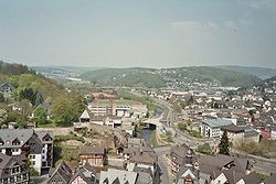
338:
114:
334:
286:
278:
93:
158:
145:
238:
217:
321:
Going downstream, the Dill's largest tributaries are: Roßbach, Haigerbach,
28:
294:
298:
246:
234:
60:
282:
266:
262:
230:
213:
229:
is a 55 km (34 mi) long river, flowing through central
242:
209:
129:
265:. The river originates at about 567 m above sea-level north of
273:(heights that reach 606 m), where the mountain ranges
360:
205:
200:
192:
184:
174:
135:
123:
113:
99:
83:
75:
66:
56:
51:
21:
245:, joining it on the right bank at the town of
8:
356:
354:
43:
350:
297:, and finally empties into the Lahn at
257:The Dill flows exclusively through the
269:-Offdilln on the eastern slope of the
37:, with the river Dill clearly visible.
18:
7:
309:district and residence town of the
196:717 km (277 sq mi)
14:
27:
137: • coordinates
33:View over Dillenburg from the
1:
385:River statistics – Dillenburg
67:Physical characteristics
188:54.9 km (34.1 mi)
176: • elevation
101: • elevation
125: • location
85: • location
441:
105:567 m (1,860 ft)
390:River statistics – Haiger
109:
71:
42:
26:
420:Rivers of the Westerwald
380:River statistics – Aßlar
180:147 m (482 ft)
405:Tributaries of the Lahn
311:House of Orange-Nassau
159:50.55083°N 8.48833°E
337:, Ambach, Rehbach,
201:Basin features
155: /
425:Rivers of Germany
223:
222:
164:50.55083; 8.48833
432:
367:
358:
341:, and Blasbach.
170:
169:
167:
166:
165:
160:
156:
153:
152:
151:
148:
102:
86:
47:
31:
19:
16:River in Germany
440:
439:
435:
434:
433:
431:
430:
429:
415:Lahn-Dill-Kreis
410:Rivers of Hesse
395:
394:
376:
371:
370:
359:
352:
347:
319:
259:Lahn-Dill-Kreis
255:
177:
163:
161:
157:
154:
149:
146:
144:
142:
141:
138:
126:
100:
84:
38:
17:
12:
11:
5:
438:
436:
428:
427:
422:
417:
412:
407:
397:
396:
393:
392:
387:
382:
375:
374:External links
372:
369:
368:
349:
348:
346:
343:
329:, Nanzenbach,
318:
315:
275:Rothaargebirge
254:
251:
221:
220:
207:
203:
202:
198:
197:
194:
190:
189:
186:
182:
181:
178:
175:
172:
171:
139:
136:
133:
132:
127:
124:
121:
120:
117:
111:
110:
107:
106:
103:
97:
96:
90:Rothaargebirge
87:
81:
80:
77:
73:
72:
69:
68:
64:
63:
58:
54:
53:
49:
48:
40:
39:
32:
24:
23:
15:
13:
10:
9:
6:
4:
3:
2:
437:
426:
423:
421:
418:
416:
413:
411:
408:
406:
403:
402:
400:
391:
388:
386:
383:
381:
378:
377:
373:
366:
364:
357:
355:
351:
344:
342:
340:
336:
332:
328:
324:
316:
314:
312:
308:
302:
300:
296:
292:
288:
284:
280:
276:
272:
271:Haincher Höhe
268:
264:
260:
252:
250:
248:
244:
240:
236:
232:
228:
219:
215:
211:
208:
204:
199:
195:
191:
187:
183:
179:
173:
168:
140:
134:
131:
128:
122:
118:
116:
112:
108:
104:
98:
95:
91:
88:
82:
78:
74:
70:
65:
62:
59:
55:
50:
46:
41:
36:
30:
25:
20:
362:
325:, Donsbach,
320:
303:
270:
261:district in
256:
226:
224:
35:Wilhelmsturm
34:
317:Tributaries
206:Progression
162: /
399:Categories
345:References
327:Dietzhölze
287:Dillenburg
279:Westerwald
237:. It is a
193:Basin size
94:Westerwald
307:Dillkreis
239:tributary
218:North Sea
150:8°29′18″E
147:50°33′3″N
52:Location
331:Schelde
299:Wetzlar
291:Herborn
247:Wetzlar
241:to the
235:Germany
61:Germany
57:Country
323:Aubach
283:Haiger
267:Haiger
253:Course
185:Length
119:
79:
76:Source
295:Aßlar
263:Hesse
231:Hesse
214:Rhine
115:Mouth
339:Lemp
277:and
243:Lahn
227:Dill
225:The
210:Lahn
130:Lahn
22:Dill
335:Aar
233:in
401::
353:^
333:,
313:.
301:.
293:,
289:,
285:,
249:.
216:→
212:→
92:/
365:)
Text is available under the Creative Commons Attribution-ShareAlike License. Additional terms may apply.