349:
Low altitude transponders typically provide service to a minimum height of 18,000 feet (5,500 m) and range of 40 nautical miles (74 km); and High altitude transponders, which typically provide service to a minimum height of 45,000 feet (14,000 m) and range of 130 nautical miles (240 km). However, many have operational restrictions largely based on line-of-sight blockage, and actual performance may be different. The U.S. Aeronautical
Information Manual states, presumably referring to high altitude DME transponders: "reliable signals may be received at distances up to 199 nautical miles at line−of−sight altitude".
271:
185:
40:
235:(1,852 m) to the target and back. The time difference between interrogation and reply minus the 50 microsecond ground transponder delay, and the pulse spacing of the reply pulses (12 microseconds in X mode and 30 microseconds in Y mode), is measured by the interrogator's timing circuitry and converted to a distance measurement (
48:
282:). It's important to understand that DME provides the physical distance between the aircraft antenna and the DME transponder antenna. This distance is often referred to as 'slant range' and depends trigonometrically upon the aircraft altitude above the transponder as well as the ground distance between them.
390:
In 2020 one company presented its 'Fifth-Generation DME'. Although compatible with existing equipment, this iteration provides greater accuracy (down to 5 meters using DME/DME triangulation), with a further reduction to 3 meters using a further refinement. The 3-meter equipment is being considered as
210:
searches for reply pulse-pairs (X-mode = 12-microsecond spacing) with the correct interval and reply pattern to its original interrogation pattern. (Pulse-pairs that are not coincident with the individual aircraft's interrogation pattern e.g. not synchronous, are referred to as filler pulse-pairs, or
164:
In its first iteration, a DME-equipped airplane used the equipment to determine and display its distance from a land-based transponder by sending and receiving pulse pairs. The ground stations are typically collocated with VORs or VORTACs. A low-power DME can be collocated with an ILS or MLS where it
339:
three letter identity. If collocated with a VOR or ILS, it will have the same identity code as the parent facility. Additionally, the DME will identify itself between those of the parent facility. The DME identity is 1,350 Hz to differentiate itself from the 1,020 Hz tone of the VOR or the
315:
A typical DME ground-based transponder beacon has a limit of 2700 interrogations per second (pulse pairs per second – pps). Thus it can provide distance information for up to 100 aircraft at a time—95% of transmissions for aircraft in tracking mode (typically 25 pps) and 5% in search mode (typically
209:
150 interrogation pulse-pairs per second. The aircraft interrogates the ground transponder with a series of pulse-pairs (interrogations) and, after a precise time delay (typically 50 microseconds), the ground station replies with an identical sequence of pulse-pairs. The DME receiver in the aircraft
172:
A newer role for DMEs is DME/DME area navigation (RNAV). Owing to the generally superior accuracy of DME relative to VOR, navigation using two DMEs (using trilateration/distance) permits operations that navigating with VOR/DME (using azimuth/distance) does not. However, it requires that the aircraft
369:
are defined by the combination of their interrogation frequency, interrogation pulse spacing, reply frequency, and reply pulse spacing. These channels are labeled 1X, 1Y, 2X, 2Y, ... 126X, 126Y. X channels (which came first) have both interrogation and reply pulse pairs spaced by 12 microseconds. Y
324:
DME frequencies are paired to VOR frequencies and a DME interrogator is designed to automatically tune to the corresponding DME frequency when the associated VOR frequency is selected. An airplane's DME interrogator uses frequencies from 1025 to 1150 MHz. DME transponders transmit on a channel
348:
The U.S. FAA has installed three DME transponder types (not including those associated with a landing system): Terminal transponders (often installed at an airport) typically provide service to a minimum height above ground of 12,000 feet (3,700 m) and range of 25 nautical miles (46 km);
222:
Less than 30 interrogation Pulse-pairs per second, as the average number of pulses in SEARCH and TRACK is limited to max 30 pulse pairs per second. The aircraft interrogator locks on to the DME ground station once it recognizes a particular reply pulse sequence has the same spacing as the original
373:
A total of 252 frequencies are defined (but not all used) for DME interrogations and replies—specifically, 962, 963, ... 1213 megahertz. Interrogation frequencies are 1025, 1026, ... 1150 megahertz (126 total), and are the same for X and Y channels. For a given channel, the reply frequency is 63
285:
For example, an aircraft directly above the DME station at 6,076 ft (1 nmi) altitude would still show 1.0 nmi (1.9 km) on the DME readout. The aircraft is technically a mile away, just a mile straight up. Slant range error is most pronounced at high altitudes when close to the DME
79:
of radio signals in the frequency band between 960 and 1215 megahertz (MHz). Line-of-visibility between the aircraft and ground station is required. An interrogator (airborne) initiates an exchange by transmitting a pulse pair, on an assigned 'channel', to the transponder ground station. The
377:
Not all defined channels/frequencies are assigned. There are assignment 'holes' centered on 1030 and 1090 megahertz to provide protection for the secondary surveillance radar (SSR) system. In many countries, there is also an assignment 'hole' centered on 1176.45 megahertz to protect the GPS L5
80:
channel assignment specifies the carrier frequency and the spacing between the pulses. After a known delay, the transponder replies by transmitting a pulse pair on a frequency that is offset from the interrogation frequency by 63 MHz and having specified separation.
381:
Precision DME (DME/P), a component of the
Microwave Landing System, is assigned to Z channels, which have a third set of interrogation and reply pulse spacings. The Z channels are multiplexed with the Y channels and do not materially affect the channel plan.
83:
DME systems are used worldwide, using standards set by the
International Civil Aviation Organization (ICAO), RTCA, the European Union Aviation Safety Agency (EASA) and other bodies. Some countries require that aircraft operating under
412:
A feeling of sovereignty, or control over a state's own navigational means. "Some states want navigation over their territory to rely on means they control. And not every country has its constellation like the U.S.' GPS or Europe's
91:
While stand-alone DME transponders are permitted, DME transponders are usually paired with an azimuth guidance system to provide aircraft with a two-dimensional navigation capability. A common combination is a DME colocated with a
96:(VOR) transmitter in a single ground station. When this occurs, the frequencies of the VOR and DME equipment are paired. Such a configuration enables an aircraft to determine its azimuth angle and distance from the station. A
356:
or other instrument approach are intended for use during an approach to a particular runway, either one or both ends. They are not authorized for general navigation; neither a minimum range nor height is specified.
316:
150 pps). Above this limit the transponder avoids overload by limiting the sensitivity (gain) of the receiver. Replies to weaker (normally the more distant) interrogations are ignored to lower the transponder load.
246:, is used by the DME receiver to calculate its distance from the DME ground station. The rate in the calculation is the velocity of the radio pulse, which is the speed of light (roughly 300,000,000
582:
332:
Technical references to X and Y channels relate only to the spacing of the individual pulses in the DME pulse pair, 12 microsecond spacing for X channels and 30 microsecond spacing for Y channels.
329:
for interrogation and 126 channels for reply. The interrogation and reply frequencies always differ by 63 MHz. The spacing and bandwidth of each channel is 1 MHz and a bandwidth of 1MHz.
126:
720:
137:
band. This
Australian domestic version was referred to by the Federal Department of Civil Aviation as DME(D) (or DME Domestic), and the later international version adopted by
398:
In the twenty-first century, aerial navigation has become increasingly reliant on satellite guidance. However, ground-based navigation will continue, for three reasons:
655:
430:
374:
megahertz below or above the interrogation frequency. The reply frequency is different for X and Y channels, and different for channels numbered 1-63 and 64-126.
498:
Minimum
Operational Performance Standards for Airborne Distance Measuring Equipment (DME) Operating Within the Radio Frequency Range of 960-1215 Megahertz
370:
channels (which were added to increase capacity) have interrogation pulse pairs spaced by 36 microseconds and reply pulse pairs spaced by 30 microseconds.
304:
294:
130:
148:
ranging function, except the roles of the equipment in the aircraft and on the ground are reversed. DME was a post-war development based on the
541:
690:
176:
A typical DME ground transponder for en-route or terminal navigation will have a 1 kW peak pulse output on the assigned UHF channel.
115:(MLS) installations. In those situations, the DME transponder frequency/pulse spacing is also paired with the ILS, LOC or MLS frequency.
659:
557:
325:
in the 962 to 1213 MHz range and receive on a corresponding channel between 1025 and 1150 MHz. The band is divided into 126
223:
interrogation sequence. Once the receiver is locked on, it has a narrower window in which to look for the echoes and can retain lock.
192:
The DME system comprises a UHF (L-band) transmitter/receiver (interrogator) in the aircraft and a UHF (L-band) receiver/transmitter (
104:) installation provides the same capabilities to civil aircraft but also provides 2-D navigation capabilities to military aircraft.
392:
290:
301:
organizations check periodically critical parameters with properly equipped aircraft to calibrate and certify DME precision.
101:
88:(IFR) be equipped with a DME interrogator; in others, a DME interrogator is only required for conducting certain operations.
715:
149:
145:
710:
458:
725:
365:
DME frequency usage, channelization and pairing with other navaids (VOR, ILS, etc.) are defined by ICAO. 252 DME
353:
108:
93:
326:
112:
441:
418:
85:
447:
417:
One advantage of the fifth-generation equipment proposed in 2020 is its ability to be function-checked by
378:
frequency. These three 'holes' remove approximately 60 megahertz from the frequencies available for use.
156:. To maintain compatibility, DME is functionally identical to the distance measuring component of TACAN.
421:, which will significantly reduce the expense and delays of previous manned certification flight tests.
639:
17:
289:
Radio-navigation aids must keep a certain degree of accuracy, given by international standards, FAA,
31:
122:
510:
Distance
Measuring Equipment (DME)Operating Within the Radio Frequency Range of 960-1215 Megahertz
270:
118:
ICAO characterizes DME transmissions as ultra high frequency (UHF). The term L-band is also used.
436:
488:; International Civil Aviation Organization; International Standards and Recommended Practices.
307:
recommends accuracy of less than the sum of 0.25 nmi plus 1.25% of the distance measured.
214:. Also, replies to other aircraft that are therefore non-synchronous also appear as squitter).
537:
298:
76:
585:, Robert W. Lilley and Robert Erikson, Federal Aviation Administration, White Paper, undated
529:
486:
Annex 10 to the
Convention on International Civil Aviation, Volume I – Radio Navigation Aids
247:
68:
121:
Developed in
Australia, DME was invented by James "Gerry" Gerrand under the supervision of
643:
596:
406:
685:
165:
provides an accurate distance to touchdown, similar to that otherwise provided by ILS
704:
279:
232:
173:
have RNAV capabilities, and some operations also require an inertial reference unit.
166:
402:
The satellite signal is extremely weak, can be spoofed, and is not always available;
675:
153:
695:
528:(2nd ed.). National Academies of Sciences, Engineering, and Medicine. 2015.
236:
193:
72:
184:
573:; Federal Aviation Administration; Advisory Circular AC 90-100A; 1 March 2007.
409:
rule requires member states to keep and maintain ground-based navigation aids;
336:
595:
U.S. Department of
Defense and Department of Transportation (December 2001).
525:
Handbook of
Frequency Allocations and Spectrum Protection for Scientific Uses
523:
681:
UK Navaids Gallery with detailed Technical Descriptions of their operation
30:
This article is about the aviation equipment. For more general usage, see
453:
211:
56:
39:
512:; European Union Aviation Safety Agency; ETSO-2C66b; 24 October 2003.
97:
533:
47:
680:
269:
231:
A radio signal takes approximately 12.36 microseconds to travel 1
183:
129:(CSIRO). Another engineered version of the system was deployed by
75:(distance) between an aircraft and a ground station by timing the
46:
38:
522:"Appendix B: IEEE Standard Letter Designations for Radar Bands".
239:), in nautical miles, then displayed on the cockpit DME display.
251:
138:
622:"U.S. National Aviation Standard for the VOR/DME/TACAN Systems"
583:"DME/DME for Alternate Position, Navigation, and Timing (APNT)"
125:
while employed as Chief of the Division of Radiophysics of the
134:
691:
U.S. National Aviation Handbook for the VOR/DME/TACAN Systems
634:
571:
U.S. Terminal and En Route Area Navigation (RNAV) Operations
169:(and, in many instances, permitting removal of the latter).
127:
Commonwealth Scientific and Industrial Research Organisation
620:
U.S. Federal Aviation Administration (2 September 1982).
107:
Low-power DME transponders are also associated with some
335:
DME facilities identify themselves with a 1,350 Hz
560:. 9 January 2013 – via The Sydney Morning Herald.
621:
188:
DME distance and VOR/ADF cockpit display instruments
646:; Federal Aviation Administration; 12 October 2017.
278:The accuracy of DME ground stations is 185 m (±0.1
133:in the early 1950s operating in the 200 MHz
274:Accuracy of various aviation navigation systems
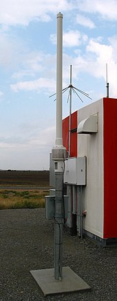
51:DME antenna beside the DME transponder shelter
8:
721:Length, distance, or range measuring devices
696:A free online VOR and ADF simulator with DME
431:Automatic dependent surveillance – broadcast
27:Radio navigation technology used in aviation
686:Flash based instrument simulator with DME
558:"Engineer exploded myths in many fields"
131:Amalgamated Wireless Australasia Limited
471:
254:). The time in the calculation is C. ½(
18:Distance measuring equipment (aviation)
656:Thales Introduces Fifth-Generation DME
597:"2001 Federal Radionavigation Systems"
481:
479:
477:
475:
7:
395:, with possible deployment by 2023.
352:DME transponders associated with an
320:Radio frequency and modulation data
297:, etc. To assure this is the case,
500:; RTCA; DO-189; 20 September 1985.
262:), where C is the speed of light.
25:
636:Aeronautical Information Manual
144:DME is similar in principle to
361:Frequency usage/channelization
1:
71:technology that measures the
150:identification friend or foe
61:distance measuring equipment
123:Edward George "Taffy" Bowen
742:
459:Transponder landing system
29:
111:(ILS), ILS localizer and
109:instrument landing system
100:(a VOR co-located with a
94:VHF omnidirectional range
642:5 September 2008 at the
113:microwave landing system
43:D-VOR/DME ground station
442:Instrument flight rules
86:instrument flight rules
448:Non-directional beacon
275:
244:distance = rate * time
242:The distance formula,
189:
52:
44:
344:DME transponder types
273:
187:
50:
42:
716:Aircraft instruments
227:Distance calculation
32:Distance measurement
437:Gee-H (navigation)
276:
190:
53:
45:
711:Navigational aids
543:978-0-309-37659-4
391:part of Europe's
299:flight inspection
196:) on the ground.
152:(IFF) systems of
77:propagation delay
16:(Redirected from
733:
726:Radio navigation
663:
662:, 11 March 2020)
653:
647:
632:
626:
625:
617:
611:
610:
608:
606:
601:
592:
586:
580:
574:
568:
562:
561:
554:
548:
547:
519:
513:
507:
501:
495:
489:
483:
250:or 186,000
69:radio navigation
21:
741:
740:
736:
735:
734:
732:
731:
730:
701:
700:
672:
667:
666:
654:
650:
644:Wayback Machine
633:
629:
619:
618:
614:
604:
602:
599:
594:
593:
589:
581:
577:
569:
565:
556:
555:
551:
544:
521:
520:
516:
508:
504:
496:
492:
484:
473:
468:
427:
388:
363:
346:
340:ILS localizer.
322:
313:
268:
229:
220:
207:
202:
182:
162:
146:secondary radar
35:
28:
23:
22:
15:
12:
11:
5:
739:
737:
729:
728:
723:
718:
713:
703:
702:
699:
698:
693:
688:
683:
678:
671:
670:External links
668:
665:
664:
648:
627:
612:
587:
575:
563:
549:
542:
534:10.17226/21774
514:
502:
490:
470:
469:
467:
464:
463:
462:
456:
451:
445:
439:
434:
426:
423:
415:
414:
410:
407:European Union
403:
387:
384:
362:
359:
345:
342:
321:
318:
312:
309:
267:
264:
228:
225:
219:
216:
206:
203:
201:
198:
181:
178:
167:marker beacons
161:
158:
26:
24:
14:
13:
10:
9:
6:
4:
3:
2:
738:
727:
724:
722:
719:
717:
714:
712:
709:
708:
706:
697:
694:
692:
689:
687:
684:
682:
679:
677:
674:
673:
669:
661:
657:
652:
649:
645:
641:
638:
637:
631:
628:
623:
616:
613:
598:
591:
588:
584:
579:
576:
572:
567:
564:
559:
553:
550:
545:
539:
535:
531:
527:
526:
518:
515:
511:
506:
503:
499:
494:
491:
487:
482:
480:
478:
476:
472:
465:
460:
457:
455:
452:
449:
446:
443:
440:
438:
435:
432:
429:
428:
424:
422:
420:
419:drone flights
411:
408:
404:
401:
400:
399:
396:
394:
393:SESAR project
385:
383:
379:
375:
371:
368:
360:
358:
355:
350:
343:
341:
338:
333:
330:
328:
319:
317:
311:Specification
310:
308:
306:
302:
300:
296:
292:
287:
283:
281:
272:
265:
263:
261:
257:
253:
249:
245:
240:
238:
234:
233:nautical mile
226:
224:
217:
215:
213:
204:
199:
197:
195:
186:
179:
177:
174:
170:
168:
159:
157:
155:
151:
147:
142:
140:
136:
132:
128:
124:
119:
116:
114:
110:
105:
103:
99:
95:
89:
87:
81:
78:
74:
70:
66:
62:
58:
49:
41:
37:
33:
19:
651:
635:
630:
615:
603:. Retrieved
590:
578:
570:
566:
552:
524:
517:
509:
505:
497:
493:
485:
416:
397:
389:
380:
376:
372:
366:
364:
351:
347:
334:
331:
323:
314:
303:
288:
284:
277:
259:
255:
243:
241:
230:
221:
208:
191:
175:
171:
163:
154:World War II
143:
120:
117:
106:
90:
82:
64:
60:
54:
36:
260:reply delay
237:slant range
205:Search mode
194:transponder
141:as DME(I).
73:slant range
705:Categories
676:DME Basics
466:References
337:Morse code
256:total time
218:Track mode
660:AW&ST
413:Galileo."
286:station.
160:Operation
640:Archived
454:Squitter
425:See also
367:channels
327:channels
266:Accuracy
212:squitter
180:Hardware
57:aviation
433:(ADS-B)
67:) is a
605:5 July
540:
386:Future
200:Timing
98:VORTAC
600:(PDF)
461:(TLS)
450:(NDB)
444:(IFR)
102:TACAN
607:2011
538:ISBN
305:ICAO
295:ICAO
291:EASA
252:mi/s
139:ICAO
530:doi
354:ILS
280:nmi
248:m/s
135:VHF
65:DME
55:In
707::
536:.
474:^
405:A
293:,
258:−
59:,
658:(
624:.
609:.
546:.
532::
63:(
34:.
20:)
Text is available under the Creative Commons Attribution-ShareAlike License. Additional terms may apply.