556:
50:
66:
605:
134:
73:
302:, in 2016, the district, along with numerous streets, were renamed to their current names. Some of the new street names adopted within the district include Boris Grinchenko St., Oleksandr Kuznetsov St, Sergeant Medvedev St., Gerhard Rempel St., Olga Kobylyanska St., Mykhailo Hrushevskyi St., Olena Teliga St., and Rosenthal St..
281:
The third smallest of
Zaporizhzhia's seven urban districts, the district has an area of 49.7 square kilometres (19.2 sq mi), making up approximately 14.88% of the total administrative area of Zaporizhzhia. The district is located mostly on the right (west) side of the
49:
555:
96:
670:
471:
65:
646:
680:
665:
675:
464:
545:
535:
639:
480:
326:
457:
286:, with a small area of land on the left side of the river. It is one of only two districts with territory to the west of the Dnieper.
540:
632:
299:
230:
564:
374:"About number and composition population of Zaporizhzhia Region by data All-Ukrainian census of the population 2001"
258:
40:
579:
484:
151:
146:
373:
270:
530:
493:
449:
209:
520:
515:
219:
612:
244:
604:
507:
427:
616:
319:
54:
Administrative map of
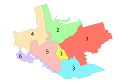
Zaporizhzhia; the Dniprovskyi District is indicated by the number 4.
659:
498:
262:
111:
98:
200:
283:
266:
139:
226:
205:
401:
348:
453:
428:"Запоріжжя позбавляється пам'ятників і назв комуністичної доби"
327:
State
Statistics Service of Ukraine in Zaporizhzhia Oblast
620:
320:"Number of the population of the City of Zaporizhzhia"
21:
578:
563:
506:
216:
199:
191:
183:
178:
170:
165:
157:
145:
127:
26:
252:
640:
465:
8:
402:"City Districts - Zaporizhzhia City Council"
349:"City Districts - Zaporizhzhia City Council"
72:
671:States and territories established in 1928
647:
633:
472:
458:
450:
23:
311:
198:
177:
164:
156:
126:
91:
58:
46:
18:City district of Zaporizhzhia, Ukraine
396:
394:
215:
190:
182:
169:
144:
7:
601:
599:
294:The district was founded in 1928 as
269:. Its population was 151,900 in the
681:Zaporizhzhia Oblast geography stubs
298:district. Following the passage of
174:49.7 km (19.2 sq mi)
666:Dniprovskyi District, Zaporizhzhia
619:. You can help Knowledge (XXG) by
14:
611:This article about a location in
257:) is one of seven administrative
603:
554:
132:
71:
64:
48:
676:1928 establishments in Ukraine
1:
253:
195:3,100/km (7,900/sq mi)
697:
598:
552:
491:
485:Zaporizhzhia Municipality
248:
152:Zaporizhzhia Municipality
92:
59:
47:
38:
481:Administrative divisions
261:(raions) of the city of
32:
265:, located in southern
494:Administrative center
378:2001.ukrcensus.gov.ua
271:2001 Ukrainian Census
218: • Summer (
112:47.87889°N 35.06389°E
426:Herasin, Volodymyr.
300:decommunization laws
241:Dniprovskyi District
192: • Density
80:Dniprovskyi District
29:Dniprovskyi District
613:Zaporizhzhia Oblast
108: /
254:Dniprovsʹkyi raion
249:Дніпровський район
184: • Total
171: • Total
117:47.87889; 35.06389
33:Дніпровський район
628:
627:
593:
592:
237:
236:
688:
649:
642:
635:
607:
600:
558:
474:
467:
460:
451:
444:
443:
441:
439:
423:
417:
416:
414:
412:
398:
389:
388:
386:
384:
370:
364:
363:
361:
359:
345:
339:
338:
336:
334:
325:(in Ukrainian).
324:
316:
256:
250:
223:
138:
136:
135:
123:
122:
120:
119:
118:
113:
109:
106:
105:
104:
101:
81:
75:
74:
68:
52:
30:
24:
696:
695:
691:
690:
689:
687:
686:
685:
656:
655:
654:
653:
596:
594:
589:
574:
559:
550:
546:Oleksandrivskyi
536:Shevchenkivskyi
502:
487:
478:
448:
447:
437:
435:
425:
424:
420:
410:
408:
400:
399:
392:
382:
380:
372:
371:
367:
357:
355:
347:
346:
342:
332:
330:
322:
318:
317:
313:
308:
292:
279:
259:urban districts
217:
133:
131:
116:
114:
110:
107:
102:
99:
97:
95:
94:
88:
87:
86:
85:
84:
83:
82:
79:
76:
55:
43:
34:
31:
28:
22:
19:
12:
11:
5:
694:
692:
684:
683:
678:
673:
668:
658:
657:
652:
651:
644:
637:
629:
626:
625:
608:
591:
590:
588:
587:
584:
582:
576:
575:
573:
572:
569:
567:
561:
560:
553:
551:
549:
548:
543:
538:
533:
528:
523:
518:
512:
510:
504:
503:
492:
489:
488:
479:
477:
476:
469:
462:
454:
446:
445:
434:(in Ukrainian)
432:Запорозька Січ
418:
390:
365:
340:
329:. 20 June 2012
310:
309:
307:
304:
291:
288:
278:
275:
235:
234:
224:
214:
213:
203:
197:
196:
193:
189:
188:
185:
181:
180:
176:
175:
172:
168:
167:
163:
162:
159:
155:
154:
149:
143:
142:
129:
125:
124:
90:
89:
78:
77:
70:
69:
63:
62:
61:
60:
57:
56:
53:
45:
44:
41:Urban district
39:
36:
35:
27:
20:
17:
13:
10:
9:
6:
4:
3:
2:
693:
682:
679:
677:
674:
672:
669:
667:
664:
663:
661:
650:
645:
643:
638:
636:
631:
630:
624:
622:
618:
614:
609:
606:
602:
597:
586:
585:
583:
581:
577:
571:
570:
568:
566:
562:
557:
547:
544:
542:
539:
537:
534:
532:
529:
527:
524:
522:
519:
517:
514:
513:
511:
509:
505:
501:
500:
495:
490:
486:
482:
475:
470:
468:
463:
461:
456:
455:
452:
433:
429:
422:
419:
407:
403:
397:
395:
391:
379:
375:
369:
366:
354:
350:
344:
341:
328:
321:
315:
312:
305:
303:
301:
297:
289:
287:
285:
284:Dnieper river
276:
274:
272:
268:
264:
260:
255:
246:
242:
232:
228:
225:
221:
211:
207:
204:
202:
194:
186:
173:
161:16 March 1928
160:
153:
150:
148:
141:
130:
121:
93:Coordinates:
67:
51:
42:
37:
25:
16:
621:expanding it
610:
595:
531:Voznesenskyi
525:
499:Zaporizhzhia
497:
438:17 September
436:. Retrieved
431:
421:
411:16 September
409:. Retrieved
405:
383:16 September
381:. Retrieved
377:
368:
358:16 September
356:. Retrieved
352:
343:
331:. Retrieved
314:
295:
293:
280:
263:Zaporizhzhia
240:
238:
147:Municipality
15:
526:Dniprovskyi
521:Komunarskyi
516:Khortytskyi
158:Established
115: /
660:Categories
333:25 January
306:References
179:Population
103:35°03′50″E
100:47°52′44″N
541:Zavodskyi
406:zp.gov.ua
353:zp.gov.ua
296:Leninskya
277:Geography
245:Ukrainian
201:Time zone
565:Hromadas
496::
290:History
267:Ukraine
187:151,900
140:Ukraine
128:Country
580:Cities
508:Raions
137:
615:is a
323:(PDF)
227:UTC+3
206:UTC+2
617:stub
440:2023
413:2023
385:2023
360:2023
335:2015
239:The
231:EEST
166:Area
483:of
220:DST
210:EET
662::
430:.
404:.
393:^
376:.
351:.
273:.
251:,
247::
648:e
641:t
634:v
623:.
473:e
466:t
459:v
442:.
415:.
387:.
362:.
337:.
243:(
233:)
229:(
222:)
212:)
208:(
Text is available under the Creative Commons Attribution-ShareAlike License. Additional terms may apply.