846:
happened that we have pronounced cé and writes only Dobsch, and then
Dobschau. But, either by corruption, either by a certain similarity of pronunciation, or finally by other causes We have also pronounced and written Topf, Topfschau, and we have derived this name from the expression Topfschauen (looking at the pot). The arms of the city represented consequently tempt a miner who looks into a pot. We relate to this regard a particular tale: it is said that the former miners having assembled to give a name to the city, had unanimously decided that we would take the word the first miner to leave the mines would say. Soon appeared in the middle from them one of their comrades who knew nothing about the deliberation, and who approached the fireplace, said he had to look at his pot, "
433:
53:
627:
72:
38:
1364:
679:
653:
640:
666:
79:
538:
period of 1867–1918, which saw a concerted effort to assimilate all non-Hungarian cultures within the empire. The enduring legacy of the German heritage was on display during a 1927 festival to celebrate the town's 600th anniversary: there ceremony was conducted in both German and
Hungarian, as
514:
The
Rosenau–Dobschin railway line opened in 1874, connecting the town to the rest of the region by rail. But the mining industry had fallen into sharp decline by this point, and the town's residents—especially its German miners—began to emigrate in large numbers to seek opportunity
505:
Although Dobšiná belonged to the Štítnice castle estate, its inhabitants were considered free burghers. The relationship with the landowners was further loosened when the ruling Bebek family line ended in 1594 . After the approval of
Maximilian's mining order in 1723, the town was exempted from the
408:
There is also a local legend, documented in 1822, that the town was named by its original German settlers. According to this legend, while cooking around a common fire, one settler suggested that the next word uttered would become the name of the settlement. When the pot began to boil, a passing
845:
The name of
Dobschau seems to be derived from that of the stream on which the city is found, and which, more than a century before its establishment, already bore the name of Dobsina, which the Slavs pronounce Dobschina. This ending is finding little in the genius of the German language, it has
558:
on their return to the country at the war's end. Among the most atrocious of these was the Prerau massacre of 18 June 1945, when trains carrying returning German residents were stopped at the
Moravian town of Prerov by a unit of the Czech intelligence commanded Karol Pazurndash—himself a
559:
native of Dobšiná. At
Pazurndash's command, 71 men, 120 women and 74 children were gunned down, and among these, 121 residents from Dobšiná. The German population of Dobšiná never recovered, and Slovaks from other parts of Czechoslovakia were later resettled into the vacant homes.
501:
Dobšiná endured a tumultuous period in the latter half of the 16th century: in 1540, the captain of the Murán Castle, Matej Bašo, plundered the town, and it was sacked and plundered again by the Turks of Fiľak on
October 14, 1584, with 352 residents dragged into captivity.
460:
The settlement was surrounded by mines, some dating back to ancient times, and it developed into a prosperous mining hub for gold, silver, and nickel, and later, for iron, cobalt, copper, mercury, and more. It also developing a thriving iron refining trade.
473:
settlement grew quickly, receiving a town charter in 1417 from
Sigismund of Luxembourg and acquiring the right of sword and the right of fair at that time. It became a major hub for the Hungarian minority of
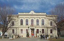
852:"; and hence the name of Topfschau. We also believed we could derive this name from the fact that the city being surrounded by very high mountains, it seemed, from their peaks, to be at the bottom of a pot.
404:
The Slavic name "Dobšiná" could be derived from the nearby Dobšinský brook, which is first recorded in historical sources as "Dupsina fluvius" in 1320 (predating any written references to the town's name).
506:
land mining tax and enjoyed the rights of a free royal town. In 1756, Mária Terézia Dobšinej confirmed the right to four annual markets, which took place on 22 February, 12 May, 1 August and 8 December.
562:
In modern times, many of Dobšiná's residents still have German surnames and can trace parts of their ancestry to its original German settlers, but few if any identify as German rather than Slavic.
424:" , which could have been in reference to the town's location at the bottom of a valley surrounded on all sides by mountains (and thus appearing to be at the bottom of a pot).
1394:
611:
1020:
696:
453:(who had ruled the surrounding territory since 1243) commissioned the hereditary magistrate Mikuláš to settle expert German miners there in the tradition of
812:
516:
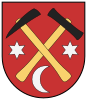
103:
1197:
551:
1092:
555:
1384:
1013:
1227:
1222:
1202:
938:
1167:
392:
and enclosed on all sides by mountains. It lies to the south of the beautiful
Stratenska Valley. The town includes the well-known
1302:
543:
519:). The town lost about 1/3 of its population during this period, falling to 5,115 inhabitants by 1900 and then 4,681 by 1930.
1262:
1006:
965:
The records for genealogical research are available at the state archive "Statny Archiv in Banska Bystrica, Kosice, Slovakia"
296:
71:
1307:
527:
437:
52:
913:
617:
268:
1297:
1207:
37:
748:
774:
717:
482:, with Germans comprising the majority of its residents for the next 450 years. They referred to themselves as "
286:
1389:
494:"; to their Hungarian and Slavic neighbors, they were "Buliners". They spoke a distinct dialect known as "
1172:
1030:
393:
369:
156:
836:. Mineralogical and geological journey in Hungary during the year 1818 (in French). Verdière. p. 94
599:
554:, with devastating effects on Dobšiná's remaining population. Tragically, many of these residents were
247:
1312:
1267:
432:
1317:
1122:
895:
657:
385:
349:
257:
1352:
1242:
531:
479:
475:
361:
329:
1132:
1127:
470:
993:
381:
146:
591:
321:
1292:
1217:
1067:
806:
626:
547:
523:
389:
353:
1378:
1332:
998:
801:
579:
535:
495:
1342:
1257:
1049:
418:
It is also possible that the German name "Dobschau" derived from the German phrase "
587:
450:
1287:
1212:
1192:
1137:
891:
683:
631:
356:. For 500 years it was a small but prosperous mining village populated by ethnic
831:
1337:
1327:
1232:
1187:
1112:
1102:
469:
With a favorable position near a river and close to rich natural resources, the
454:
415:" . "Topf schaue" sounds very similar to the town's German name, "Dobschau".
917:
1277:
1247:
1147:
1097:
1087:
1077:
865:
644:
583:
972:
Greek Catholic church records (births/marriages/deaths): 1818–1895 (parish B)
969:
Roman Catholic church records (births/marriages/deaths): 1746–1923 (parish A)
118:
105:
1272:
1152:
595:
238:
1182:
1142:
670:
457:. In exchange, he was awarded one-third of the revenue of the local mines.
1363:
1347:
1282:
1072:
1252:
1237:
1107:
1062:
975:
Lutheran church records (births/marriages/deaths): 1626–1944 (parish A)
816:. Vol. 8 (11th ed.). Cambridge University Press. p. 352.
678:
652:
639:
575:
365:
357:
1322:
1177:
1117:
1082:
1057:
665:
571:
264:
243:
833:
Mineralogical and geological journey to Hungary during the year 1818
594:, 33.58 percent people without religious affiliation, 25.25 percent
1162:
1157:
755:(in Slovak). Statistical Office of the Slovak Republic. 2015-04-17
449:
The earliest written reference to Dobšiná dates to 1326, when the
431:
337:
534:. Dobšiná's status as a German enclave endured even through the
345:
1002:
773:
Statistical Office of the Slovak Republic (www.statistics.sk).
716:
Statistical Office of the Slovak Republic (www.statistics.sk).
805:
436:
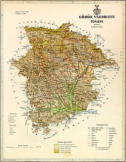
Dobšiná can be found at the northern edge of this 1802 map of
574:, the town had 4,896 inhabitants, of whom 88.58 percent were
539:
the former was still spoken by a majority of its residents.
916:. Statistical Office of the Slovak republic. Archived from
985:
309:
380:
It is situated between the Revúca Highlands and the
409:
settler (unaware of the prior discussion) shouted "
305:
295:
285:
275:
254:
237:
229:
221:
216:
208:
196:
188:
183:
175:
170:
162:
152:
142:
134:
21:
775:"Počet obyvateľov podľa pohlavia - obce (ročne)"
612:List of twin towns and sister cities in Slovakia
1014:
825:
823:
201:
8:
908:
906:
847:
697:List of municipalities and towns in Slovakia
590:. The religious structure was 35.23 percent
489:
483:
419:
410:
743:
741:
739:
737:
542:From 1939 to 1945, Dobšiná was part of the
1021:
1007:
999:
18:
1395:Mining communities in the Slovak Republic
796:
794:
522:Before the establishment of independent
708:
517:booming coal towns of the United States
304:
294:
274:
236:
215:
207:
182:
169:
161:
133:
98:
64:
46:
34:
368:town of 6,000 most well known for its
546:. When World War II erupted, much of
284:
253:
228:
220:
195:
192:82.73 km (31.94 sq mi)
187:
174:
151:
141:
7:
994:Surnames of living people in Dobsina
890:Chovan, Branislav (April 23, 2007)
866:"The Carpathian Germans - History"
552:forcibly expelled from the country
14:
1362:
677:
664:
651:
638:
625:
550:'s ethnic German population was
77:
70:
51:
36:
849:er miszte su seinem Topfschauen
91:Location of Dobšiná in Slovakia
78:
1:
718:"Hustota obyvateľstva - obce"
526:in 1918, Dobšiná was part of
1385:Cities and towns in Slovakia
515:elsewhere (many seeking the
396:, first discovered in 1870.
1411:
749:"Základná charakteristika"
609:
606:Twin towns — sister cities
212:459 m (1,506 ft)
1359:
1037:
892:"Dobšiná: History Talks."
99:
65:
47:
35:
28:
864:Karpatendeutschen, Die.
528:Gömör and Kishont County
510:Decline: 1850–1950
813:Encyclopædia Britannica
634:, Czech Republic (1997)
465:Growth: 1400–1850
388:, watered by the river
1208:Krásnohorské Podhradie
1203:Krásnohorská Dlhá Lúka
961:Genealogical resources
914:"Municipal Statistics"
848:
570:According to the 2001
490:
484:
441:
420:
411:
333:
325:
233:62/km (160/sq mi)
435:
256: • Summer (
119:48.82056°N 20.36583°E
945:(in Slovak). Dobšiná
896:The Slovak Spectator
830:Beudant, FS (1822).
438:Gömör-Kishont county
350:Slovak Ore Mountains
230: • Density
42:Town hall in Dobšiná
1173:Jablonov nad Turňou
900:(Retrieved 7-7-13.)
870:karpatendeutsche.de
115: /
1029:Municipalities of
939:"Partnerské mestá"
532:Kingdom of Hungary
476:Carpathian Germans
442:
362:Kingdom of Hungary
222: • Total
189: • Total
176: • Mayor
124:48.82056; 20.36583
1372:
1371:
1318:Silická Jablonica
779:www.statistics.sk
753:www.statistics.sk
722:www.statistics.sk
598:and 0.47 percent
586:and 0.27 percent
382:Volovec Mountains
315:
314:
1402:
1367:
1366:
1298:Rožňavské Bystré
1031:Rožňava District
1023:
1016:
1009:
1000:
990:
986:Official website
954:
953:
951:
950:
935:
929:
928:
926:
925:
910:
901:
888:
882:
881:
879:
877:
861:
855:
854:
851:
842:
841:
827:
818:
817:
809:
798:
789:
788:
786:
785:
770:
764:
763:
761:
760:
745:
732:
731:
729:
728:
713:
686:, Hungary (2011)
682:
681:
669:
668:
660:, Hungary (2000)
656:
655:
647:, Germany (1999)
643:
642:
630:
629:
493:
487:
423:
414:
394:Dobšiná Ice Cave
364:; today it is a
261:
203:
130:
129:
127:
126:
125:
120:
116:
113:
112:
111:
108:
81:
80:
74:
55:
40:
19:
16:Town in Slovakia
1410:
1409:
1405:
1404:
1403:
1401:
1400:
1399:
1375:
1374:
1373:
1368:
1361:
1357:
1313:Silická Brezová
1133:Gemerská Poloma
1128:Gemerská Panica
1033:
1027:
988:
982:
963:
958:
957:
948:
946:
937:
936:
932:
923:
921:
912:
911:
904:
889:
885:
875:
873:
863:
862:
858:
839:
837:
829:
828:
821:
807:"Dobsina"
800:
799:
792:
783:
781:
772:
771:
767:
758:
756:
747:
746:
735:
726:
724:
715:
714:
710:
705:
693:
676:
673:, Poland (2007)
663:
650:
637:
624:
614:
608:
600:Greek Catholics
592:Roman Catholics
582:, 0.63 percent
578:, 9.01 percent
568:
544:Slovak Republic
512:
467:
447:
430:
412:Im Topf schaue!
402:
378:
281:
255:
163:First mentioned
123:
121:
117:
114:
109:
106:
104:
102:
101:
95:
94:
93:
92:
89:
88:
87:
86:
82:
61:
60:
59:
58:
43:
31:
24:
17:
12:
11:
5:
1408:
1406:
1398:
1397:
1392:
1390:Gemer (region)
1387:
1377:
1376:
1370:
1369:
1360:
1358:
1356:
1355:
1350:
1345:
1340:
1335:
1330:
1325:
1320:
1315:
1310:
1305:
1300:
1295:
1290:
1285:
1280:
1275:
1270:
1265:
1260:
1255:
1250:
1245:
1240:
1235:
1230:
1225:
1220:
1218:Kunova Teplica
1215:
1210:
1205:
1200:
1195:
1190:
1185:
1180:
1175:
1170:
1165:
1160:
1155:
1150:
1145:
1140:
1135:
1130:
1125:
1123:Gemerská Hôrka
1120:
1115:
1110:
1105:
1100:
1095:
1090:
1085:
1080:
1075:
1070:
1065:
1060:
1054:
1053:
1046:
1038:
1035:
1034:
1028:
1026:
1025:
1018:
1011:
1003:
997:
996:
991:
981:
980:External links
978:
977:
976:
973:
970:
962:
959:
956:
955:
930:
902:
883:
856:
819:
804:, ed. (1911).
802:Chisholm, Hugh
790:
765:
733:
707:
706:
704:
701:
700:
699:
692:
689:
688:
687:
674:
661:
658:Sajószentpéter
648:
635:
607:
604:
567:
564:
548:Czechoslovakia
524:Czechoslovakia
511:
508:
466:
463:
446:
443:
429:
426:
401:
398:
377:
374:
313:
312:
310:www.dobsina.sk
307:
303:
302:
299:
293:
292:
289:
283:
282:
279:
277:
273:
272:
262:
252:
251:
241:
235:
234:
231:
227:
226:
223:
219:
218:
214:
213:
210:
206:
205:
198:
194:
193:
190:
186:
185:
181:
180:
177:
173:
172:
168:
167:
164:
160:
159:
154:
150:
149:
144:
140:
139:
136:
132:
131:
97:
96:
90:
84:
83:
76:
75:
69:
68:
67:
66:
63:
62:
56:
50:
49:
48:
45:
44:
41:
33:
32:
29:
26:
25:
22:
15:
13:
10:
9:
6:
4:
3:
2:
1407:
1396:
1393:
1391:
1388:
1386:
1383:
1382:
1380:
1365:
1354:
1351:
1349:
1346:
1344:
1341:
1339:
1336:
1334:
1331:
1329:
1326:
1324:
1321:
1319:
1316:
1314:
1311:
1309:
1306:
1304:
1301:
1299:
1296:
1294:
1291:
1289:
1286:
1284:
1281:
1279:
1276:
1274:
1271:
1269:
1266:
1264:
1261:
1259:
1256:
1254:
1251:
1249:
1246:
1244:
1241:
1239:
1236:
1234:
1231:
1229:
1226:
1224:
1221:
1219:
1216:
1214:
1211:
1209:
1206:
1204:
1201:
1199:
1196:
1194:
1191:
1189:
1186:
1184:
1181:
1179:
1176:
1174:
1171:
1169:
1166:
1164:
1161:
1159:
1156:
1154:
1151:
1149:
1146:
1144:
1141:
1139:
1136:
1134:
1131:
1129:
1126:
1124:
1121:
1119:
1116:
1114:
1111:
1109:
1106:
1104:
1101:
1099:
1096:
1094:
1093:Čierna Lehota
1091:
1089:
1086:
1084:
1081:
1079:
1076:
1074:
1071:
1069:
1066:
1064:
1061:
1059:
1056:
1055:
1052:
1051:
1047:
1045:
1044:
1040:
1039:
1036:
1032:
1024:
1019:
1017:
1012:
1010:
1005:
1004:
1001:
995:
992:
987:
984:
983:
979:
974:
971:
968:
967:
966:
960:
944:
940:
934:
931:
920:on 2008-01-11
919:
915:
909:
907:
903:
899:
897:
893:
887:
884:
871:
867:
860:
857:
853:
850:
835:
834:
826:
824:
820:
815:
814:
808:
803:
797:
795:
791:
780:
776:
769:
766:
754:
750:
744:
742:
740:
738:
734:
723:
719:
712:
709:
702:
698:
695:
694:
690:
685:
680:
675:
672:
667:
662:
659:
654:
649:
646:
641:
636:
633:
628:
623:
622:
621:
619:
613:
605:
603:
601:
597:
593:
589:
585:
581:
577:
573:
565:
563:
560:
557:
553:
549:
545:
540:
537:
536:Magyarization
533:
529:
525:
520:
518:
509:
507:
503:
499:
497:
496:Zipser German
492:
486:
481:
477:
472:
464:
462:
458:
456:
452:
444:
439:
434:
427:
425:
422:
416:
413:
406:
399:
397:
395:
391:
387:
383:
375:
373:
371:
367:
363:
359:
355:
351:
347:
344:) is a small
343:
339:
335:
331:
327:
323:
319:
311:
308:
300:
298:
290:
288:
278:
270:
266:
263:
259:
249:
245:
242:
240:
232:
224:
211:
199:
191:
178:
165:
158:
155:
148:
145:
137:
128:
100:Coordinates:
73:
54:
39:
27:
20:
1048:
1042:
1041:
964:
947:. Retrieved
942:
933:
922:. Retrieved
918:the original
894:
886:
874:. Retrieved
869:
859:
844:
838:. Retrieved
832:
811:
782:. Retrieved
778:
768:
757:. Retrieved
752:
725:. Retrieved
721:
711:
615:
569:
566:Demographics
561:
541:
521:
513:
504:
500:
471:Gömör County
468:
459:
451:Bebek family
448:
417:
407:
403:
379:
341:
317:
316:
291:+421 58
57:Coat of arms
1353:Vyšná Slaná
1243:Nižná Slaná
1188:Kobeliarovo
989:(in Slovak)
876:23 November
872:(in German)
616:Dobšiná is
530:within the
455:Krupina law
421:topfschauen
386:Carpathians
360:within the
354:Slaná River
280:049 25
276:Postal code
122: /
1379:Categories
1333:Slavošovce
949:2019-09-09
943:dobsina.sk
924:2008-01-31
840:2021-11-24
784:2024-02-08
759:2022-03-31
727:2024-02-08
703:References
645:Teistungen
610:See also:
584:Hungarians
491:Topschauer
485:Dobschauer
445:Settlement
352:along the
217:Population
179:Ján Slovák
171:Government
110:20°21′57″E
107:48°49′14″N
1273:Rakovnica
1193:Koceľovce
1153:Henckovce
1138:Gočaltovo
684:Rudabánya
632:Šternberk
596:Lutherans
556:massacred
400:Etymology
376:Geography
342:Dobsinium
330:Hungarian
297:Car plate
287:Area code
239:Time zone
209:Elevation
1348:Vlachovo
1338:Stratená
1328:Slavoška
1293:Rozložná
1283:Rochovce
1268:Plešivec
1233:Markuška
1223:Lipovník
1198:Kováčová
1113:Dlhá Ves
1068:Bohúňovo
691:See also
370:Ice Cave
326:Dobschau
153:District
138:Slovakia
1343:Štítnik
1278:Rejdová
1263:Petrovo
1258:Pašková
1248:Ochtiná
1238:Meliata
1148:Hanková
1108:Dedinky
1098:Čoltovo
1088:Brzotín
1078:Brdárka
1063:Betliar
1050:Rožňava
1043:Dobšiná
618:twinned
576:Slovaks
480:Hungary
478:within
428:History
384:in the
358:Germans
348:in the
334:Dobsina
318:Dobšiná
306:Website
157:Rožňava
135:Country
85:Dobšiná
23:Dobšiná
1323:Slavec
1308:Silica
1288:Roštár
1213:Kružná
1183:Kečovo
1178:Jovice
1168:Hrušov
1143:Gočovo
1118:Drnava
1083:Bretka
1058:Ardovo
671:Kobiór
620:with:
588:Czechs
572:census
488:" or "
390:Hnilec
366:Slovak
322:German
197:
147:Košice
143:Region
1303:Rudná
1228:Lúčka
1163:Hrhov
1158:Honce
1103:Čučma
1073:Bôrka
338:Latin
265:UTC+2
244:UTC+1
225:5,143
1253:Pača
878:2021
580:Roma
346:town
269:CEST
202:2022
184:Area
166:1326
30:Town
498:".
258:DST
248:CET
1381::
941:.
905:^
868:.
843:.
822:^
810:.
793:^
777:.
751:.
736:^
720:.
602:.
372:.
340::
336:;
332::
328:;
324::
301:RV
1022:e
1015:t
1008:v
952:.
927:.
898:.
880:.
787:.
762:.
730:.
440:.
320:(
271:)
267:(
260:)
250:)
246:(
204:)
200:(
Text is available under the Creative Commons Attribution-ShareAlike License. Additional terms may apply.