205:
38:
30:
22:
317:
246:
258:
297:
312:
239:
302:
137:
232:
64:. A 10 mph speed limit was in operation. The line opened in 1883. Trains ran until 1964 and the viaduct was dismantled in 1965.
322:
307:
111:
A walk along the footpath that follows the railway route reveals the brick pillar bases that remain in the dell.
327:
76:
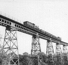
supported on trestles, a combination of which there may have been only one other example in
Britain, at
204:
60:, was a 234 yards (214 m), nine span lattice steel, single-track railway viaduct that carried the
188:
Black & white photograph taken from a train crossing the viaduct in
November 1963 by ricsrailpics
100:
16:
Railway viaduct that carried the
Halesowen to Longbridge railway until it was dismantled in 1964
182:
37:
133:
77:
61:
99:; and other lattice girders are low structures supported typically on iron caissons, such as
92:
216:
212:
187:
183:
Two colour slides of the viaduct and track taken by photographer D J Norton in May 1955
73:
57:
291:
88:
84:
96:
29:
273:
260:
153:
53:
21:
49:
80:(extant), though in that instance the trestles are not as high.
36:
28:
20:
41:
Dowery Dell
Viaduct with steam train passing towards Longbridge
154:"Old Hill to Halesowen and Longbridge (The Halesowen Railway)"
132:. Midhurst, West Sussex: Middleton Press. pp. 61–62.
95:, the superstructure is not a lattice, being typically a
83:
On other well-known trestle-supported viaducts, such as
72:
The viaduct was remarkable in being a rare example of a
220:
160:. Malvern Industrial Archaeology Circle (MIAC)
240:
8:
318:Buildings and structures demolished in 1964
247:
233:
120:
7:
201:
199:
128:Mitchell, Vic; Smith, Keith (2007).
33:Dowery Dell Viaduct showing one pier
14:
203:
62:Halesowen to Longbridge railway
298:Worcestershire geography stubs
1:
313:Demolished bridges in England
219:. You can help Knowledge by
130:Stourbridge to Wolverhampton
303:Geography of Worcestershire
344:
198:
158:Railways in Worcestershire
274:52.423374°N 2.039359°W
215:location article is a
42:
34:
26:
323:Great Western Railway
40:
32:
24:
279:52.423374; -2.039359
308:Viaducts in England
270: /
25:Dowery Dell Viaduct
101:Kew Railway Bridge
68:Similar structures
43:
35:
27:
228:
227:
78:Bennerley Viaduct
335:
285:
284:
282:
281:
280:
275:
271:
268:
267:
266:
263:
249:
242:
235:
207:
200:
170:
169:
167:
165:
150:
144:
143:
125:
343:
342:
338:
337:
336:
334:
333:
332:
328:Midland Railway
288:
287:
278:
276:
272:
269:
264:
261:
259:
257:
256:
254:
253:
196:
193:
179:
174:
173:
163:
161:
152:
151:
147:
140:
127:
126:
122:
117:
109:
70:
17:
12:
11:
5:
341:
339:
331:
330:
325:
320:
315:
310:
305:
300:
290:
289:
252:
251:
244:
237:
229:
226:
225:
213:Worcestershire
208:
191:
190:
185:
178:
177:External links
175:
172:
171:
145:
138:
119:
118:
116:
113:
108:
105:
74:lattice girder
69:
66:
58:Worcestershire
15:
13:
10:
9:
6:
4:
3:
2:
340:
329:
326:
324:
321:
319:
316:
314:
311:
309:
306:
304:
301:
299:
296:
295:
293:
286:
283:
250:
245:
243:
238:
236:
231:
230:
224:
222:
218:
214:
209:
206:
202:
197:
194:
189:
186:
184:
181:
180:
176:
159:
155:
149:
146:
141:
139:9781906008161
135:
131:
124:
121:
114:
112:
106:
104:
102:
98:
94:
90:
86:
81:
79:
75:
67:
65:
63:
59:
55:
51:
47:
39:
31:
23:
19:
255:
221:expanding it
210:
195:
192:
162:. Retrieved
157:
148:
129:
123:
110:
97:Warren truss
82:
71:
45:
44:
18:
277: /
164:16 November
46:Dowery Dell
292:Categories
262:52°25′24″N
115:References
48:, between
265:2°02′22″W
54:Halesowen
107:Remains
93:Crumlin
136:
91:, and
85:Meldon
50:Rubery
211:This
89:Belah
217:stub
166:2022
134:ISBN
52:and
56:in
294::
156:.
103:.
87:,
248:e
241:t
234:v
223:.
168:.
142:.
Text is available under the Creative Commons Attribution-ShareAlike License. Additional terms may apply.