61:
734:
49:
81:
114:
388:
121:
88:
521:
In the township the population was spread out, with 31.1% under the age of 18, 7.2% from 18 to 24, 30.6% from 25 to 44, 23.0% from 45 to 64, and 8.1% who were 65 years of age or older. The median age was 34 years. For every 100 females, there were 111.7 males. For every 100 females age 18 and over,
517:
living together, 5.1% had a female householder with no husband present, and 23.4% were non-families. 20.6% of all households were made up of individuals, and 6.5% had someone living alone who was 65 years of age or older. The average household size was 2.86 and the average family size was 3.26.
497:
of 2000, there were 614 people, 214 households, and 163 families residing in the township. The population density was 17.4 inhabitants per square mile (6.7/km). There were 368 housing units at an average density of 10.5 per square mile (4.1/km). The racial makeup of the township was 98.53%
525:
The median income for a household in the township was $ 45,000, and the median income for a family was $ 48,036. Males had a median income of $ 31,458 versus $ 26,042 for females. The
149:
485:, the township has a total area of 35.22 square miles (91.22 km), of which 35.17 square miles (91.09 km) is land and 0.04 square miles (0.10 km) (0.14%) is water.
672:
967:
957:
781:
17:
972:
440:
801:
365:
60:
665:
638:
113:
80:
375:
873:
658:
627:
Michigan Place Names: The
History of the Founding and the Naming of More Than Five Thousand Past and Present Michigan Communities
312:
589:
962:
811:
434:
392:
650:
806:
503:
48:
868:
630:
201:
776:
557:
482:
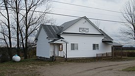
468:. The area was first settled by William Sparr in 1873 and was named after him. The community of Sparr grew when the
472:
constructed a line through the township. A post office opened on May 5, 1915, and operated until
February 15, 1932.
842:
786:
796:
771:
414:
904:
893:
847:
353:
613:
577:
927:
852:
831:
745:
682:
513:
There were 214 households, out of which 42.1% had children under the age of 18 living with them, 67.3% were
406:
206:
66:
863:
883:
878:
934:
753:
322:
857:
821:
578:
U.S. Geological Survey
Geographic Names Information System: Dover Township, Otsego County, Michigan
507:
499:
469:
430:
529:
for the township was $ 22,739. About 4.1% of families and 6.4% of the population were below the
723:
704:
634:
526:
344:
899:
836:
888:
235:
763:
402:
39:
951:
358:
530:
697:
189:
455:
442:
164:
151:
303:
614:
U.S. Geological Survey
Geographic Names Information System: Sparr, Michigan
533:, including 9.0% of those under age 18 and 13.7% of those age 65 or over.
918:‡This populated place also has portions in an adjacent county or counties
514:
410:
337:
194:
733:
387:
494:
386:
329:
308:
715:
654:
732:
629:(Paperback). Great Lakes Books Series. Detroit, Michigan:
553:
16:
For other places in
Michigan named Dover Township, see
913:
820:
762:
744:
714:
374:
364:
352:
336:
319:
302:
294:
286:
281:
273:
265:
257:
249:
244:
233:
225:
220:
212:
200:
188:
180:
30:
737:Map of Michigan highlighting Otsego County.svg
666:
8:
673:
659:
651:
27:
470:Boyne City, Gaylord & Alpena Railroad
25:Civil township in Michigan, United States
18:Dover Township, Michigan (disambiguation)
542:
363:
335:
301:
280:
272:
243:
219:
211:
179:
144:
72:
57:
45:
120:
87:
548:
546:
373:
351:
318:
293:
285:
264:
261:35.17 sq mi (91.09 km)
256:
253:35.22 sq mi (91.22 km)
248:
232:
224:
199:
187:
100:Location within the state of Michigan
7:
968:Populated places established in 1879
958:Townships in Otsego County, Michigan
510:, and 0.65% from two or more races.
269:0.04 sq mi (0.10 km)
681:Municipalities and communities of
625:Romig, Walter (October 1, 1986) .
433:located within the township along
14:
133:Location within the United States
413:. The population was 632 at the
119:
112:
86:
79:
59:
47:
973:1879 establishments in Michigan
1:
136:Show map of the United States
631:Wayne State University Press
558:United States Census Bureau
989:
277:1,145 ft (349 m)
15:
923:
730:
695:
456:45.0414009°N 84.5725252°W
391:Community of Sparr along
145:
73:
58:
46:
37:
522:there were 112.6 males.
431:unincorporated community
32:Dover Township, Michigan
684:Otsego County, Michigan
461:45.0414009; -84.5725252
226: • Supervisor
738:
395:
298:18/sq mi (6.9/km)
963:Townships in Michigan
736:
590:"Explore Census Data"
554:"U.S. Census website"
409:in the U.S. state of
390:
321: • Summer (
165:45.07389°N 84.55861°W
936:United States portal
295: • Density
103:Show map of Michigan
452: /
170:45.07389; -84.55861
161: /
53:Dover Township Hall
869:Lower Chub Landing
739:
483:U.S. Census Bureau
396:
287: • Total
266: • Water
250: • Total
945:
944:
640:978-0-8143-1838-6
527:per capita income
481:According to the
385:
384:
258: • Land
980:
937:
930:
843:Eyedylwild Beach
735:
707:
700:
690:
685:
675:
668:
661:
652:
645:
644:
622:
616:
611:
605:
604:
602:
600:
586:
580:
575:
569:
568:
566:
564:
550:
467:
466:
464:
463:
462:
457:
453:
450:
449:
448:
445:
326:
176:
175:
173:
172:
171:
166:
162:
159:
158:
157:
154:
137:
123:
122:
116:
104:
90:
89:
83:
65:Location within
63:
51:
28:
988:
987:
983:
982:
981:
979:
978:
977:
948:
947:
946:
941:
935:
929:Michigan portal
928:
919:
909:
823:
816:
764:Civil townships
758:
740:
728:
710:
705:
698:
691:
688:
683:
679:
649:
648:
641:
633:. p. 528.
624:
623:
619:
612:
608:
598:
596:
594:data.census.gov
588:
587:
583:
576:
572:
562:
560:
552:
551:
544:
539:
515:married couples
504:Native American
491:
479:
460:
458:
454:
451:
446:
443:
441:
439:
438:
423:
348:
320:
169:
167:
163:
160:
155:
152:
150:
148:
147:
141:
140:
139:
138:
135:
134:
131:
130:
129:
128:
124:
107:
106:
105:
102:
101:
98:
97:
96:
95:
91:
69:
54:
42:
33:
26:
21:
12:
11:
5:
986:
984:
976:
975:
970:
965:
960:
950:
949:
943:
942:
940:
939:
932:
924:
921:
920:
917:
915:
911:
910:
908:
907:
905:Whites Landing
902:
897:
894:Vienna Corners
891:
886:
881:
876:
871:
866:
861:
855:
850:
848:Farrar Landing
845:
840:
834:
828:
826:
822:Unincorporated
818:
817:
815:
814:
809:
804:
799:
794:
789:
784:
779:
774:
768:
766:
760:
759:
757:
756:
750:
748:
742:
741:
731:
729:
727:
726:
720:
718:
712:
711:
696:
693:
692:
680:
678:
677:
670:
663:
655:
647:
646:
639:
617:
606:
581:
570:
541:
540:
538:
535:
490:
487:
478:
475:
474:
473:
422:
419:
403:civil township
399:Dover Township
383:
382:
379:
372:
371:
368:
362:
361:
356:
350:
349:
342:
340:
334:
333:
327:
317:
316:
306:
300:
299:
296:
292:
291:
288:
284:
283:
279:
278:
275:
271:
270:
267:
263:
262:
259:
255:
254:
251:
247:
246:
242:
241:
238:
231:
230:
227:
223:
222:
218:
217:
214:
210:
209:
204:
198:
197:
192:
186:
185:
182:
178:
177:
143:
142:
132:
127:Dover Township
126:
125:
118:
117:
111:
110:
109:
108:
99:
94:Dover Township
93:
92:
85:
84:
78:
77:
76:
75:
74:
71:
70:
64:
56:
55:
52:
44:
43:
40:Civil township
38:
35:
34:
31:
24:
13:
10:
9:
6:
4:
3:
2:
985:
974:
971:
969:
966:
964:
961:
959:
956:
955:
953:
938:
933:
931:
926:
925:
922:
916:
912:
906:
903:
901:
898:
895:
892:
890:
887:
885:
882:
880:
877:
875:
872:
870:
867:
865:
862:
859:
856:
854:
853:Green Timbers
851:
849:
846:
844:
841:
838:
835:
833:
832:Arbutus Beach
830:
829:
827:
825:
819:
813:
810:
808:
805:
803:
800:
798:
795:
793:
790:
788:
785:
783:
780:
778:
775:
773:
770:
769:
767:
765:
761:
755:
752:
751:
749:
747:
743:
725:
722:
721:
719:
717:
713:
709:
708:
701:
694:
689:United States
686:
676:
671:
669:
664:
662:
657:
656:
653:
642:
636:
632:
628:
621:
618:
615:
610:
607:
595:
591:
585:
582:
579:
574:
571:
559:
555:
549:
547:
543:
536:
534:
532:
528:
523:
519:
516:
511:
509:
505:
501:
496:
488:
486:
484:
476:
471:
465:
436:
432:
428:
425:
424:
420:
418:
416:
412:
408:
407:Otsego County
404:
400:
394:
389:
380:
377:
369:
367:
360:
357:
355:
346:
341:
339:
331:
328:
324:
314:
313:Eastern (EST)
310:
307:
305:
297:
289:
276:
268:
260:
252:
239:
237:
234: •
228:
215:
208:
205:
203:
196:
193:
191:
184:United States
183:
174:
146:Coordinates:
115:
82:
68:
67:Otsego County
62:
50:
41:
36:
29:
23:
19:
864:Johannesburg
791:
703:
626:
620:
609:
597:. Retrieved
593:
584:
573:
561:. Retrieved
531:poverty line
524:
520:
512:
492:
489:Demographics
480:
426:
398:
397:
240:Janet Kwapis
22:
884:Pearll City
879:Otsego Lake
824:communities
812:Otsego Lake
699:County seat
563:January 31,
459: /
421:Communities
415:2020 census
338:ZIP code(s)
213:Established
168: /
952:Categories
807:Livingston
754:Vanderbilt
537:References
493:As of the
447:84°34′21″W
444:45°02′29″N
378:feature ID
282:Population
221:Government
156:84°33′31″W
153:45°04′26″N
914:Footnotes
874:Oak Grove
858:Hetherton
599:April 30,
477:Geography
366:FIPS code
354:Area code
304:Time zone
274:Elevation
229:Rudi Edel
777:Charlton
506:, 0.33%
502:, 0.49%
411:Michigan
370:26-22840
195:Michigan
787:Corwith
782:Chester
746:Village
724:Gaylord
706:Gaylord
381:1626190
345:Gaylord
343:49735 (
181:Country
900:Waters
837:Elmira
797:Elmira
772:Bagley
637:
495:census
429:is an
207:Otsego
202:County
889:Sparr
802:Hayes
792:Dover
508:Asian
500:White
427:Sparr
401:is a
332:(EDT)
330:UTC-4
309:UTC-5
236:Clerk
190:State
716:City
635:ISBN
601:2024
565:2008
435:F-44
393:F-44
376:GNIS
245:Area
216:1879
437:at
405:of
359:989
323:DST
290:632
954::
702::
687:,
592:.
556:.
545:^
417:.
896:‡
860:‡
839:‡
674:e
667:t
660:v
643:.
603:.
567:.
347:)
325:)
315:)
311:(
20:.
Text is available under the Creative Commons Attribution-ShareAlike License. Additional terms may apply.