209:
196:
189:, alongside red deer, were discarded because of the risk that the harsh winter climate would have driven these animals into the valleys, where they might pose a safety hazard to people as they would be too close to the villages. With fencing the animals could certainly be kept up high, but that would mean an outdoor enclosure, which is contrary to the concept of a national park, which has to set aside 75% of its area as undisturbed wilderness, and only 25% of the area may be managed in order to achieve a specific human aim.
58:
217:
17:
129:
137:
terrain was used as a military training area, and, as a result, large tracts have reached a natural state similar to that of ancient forests in which old and dead trees have not been cut or cleared. The preservation of this natural forest as a habitat for, in some cases rare, species of animal like the
168:
To leave the land to itself would, over time, normally result in the encroachment of bushes and reforestation of those areas. Although the deer will create a few clearings, the natural supply of food is not enough to keep larger areas permanently open. Plans to support the maintenance of open land by
224:
In 2007 the hiking network on the
Dreiborn Plateau was signed and expanded to about 50 kilometres of path. Walkers must not leave the designated paths to stray into the countryside because there may still be live ammunition lying around from its days as part of the training area. Traces of old tank
136:
Thick beech, oak and spruce woods surround the streams and reservoirs at a height of about 350 metres, that border the
Dreiborn Plateau. These woods climb steeply from the valley sides to the high plateau 500 metres above the valley floor. The woods were not managed for almost 60 years, whilst the
161:, which is a popular tourist attraction during its blossom time in May. The National Park authority is still working out whether and to what extent this open countryside can and should be preserved as a former cultural landscape, in order to maintain the views and to enable visitors to see
156:
The open terrain of the plateau, which was used for agriculture and sheep-grazing before the establishment of the training area in 1946 and was thus a cultural landscape, is dominated today by the broad grasslands of the
48:
which was handed back on 31 December 2005 and had been out-of-bounds to the public since 1 September 1946. Since 2006 parts of the area have been opened up to the public who may use certain routes through it.
108:("Healing Stone Spring"), rediscovered in 1863 and probably used as early as Roman times. The B 266 divides the plateau into northern and southern halves. A rise at 517 metres (so-called
192:
Out of the conflicting views, it appears likely in the early 21st century that the
Dreiborn Plateau will be allowed to become largely reforested over the coming generations.
305:
120:
are accessible on paths in the northern half; the hills of
Klusenberg, Gierberg and Müsauelsberg, at 577 metres the highest point, lie in the southern section.
349:
104:
The plateau is bisected in an east to west direction by the B 266 federal road along the
Sauerbach stream, on which is located the so-called
232:
from
Erkensruhr and Hirschrott to the hills of the Gierberg and Müsauelsberg, along the source streams of the Erkensruhr and to Dreiborn,
292:
280:
266:
45:
344:
208:
195:
57:
235:
along the
Sauerbach and Helingsbach streams between Einruhr and Dreiborn, Einruhr, Vogelsang and Wollseifen
78:
248:
Ranger guided tours are undertaken by the
National Park authority, but many walkers do their own thing.
86:
21:
41:
117:
74:
276:
262:
20:
On the footpath over the
Dreiborn Plateau from Wollseifen to the Urft Dam: view of the former
82:
70:
242:
Many routes can be combined in order to do a circular walk. Some are also open to cyclists.
138:
273:
Tier- und
Pflanzenwelt im Nationalpark Eifel: ein Begleiter durch Wald, Wasser und Wildnis.
165:
that are active during the day at specially selected sites, such as observation platforms.
33:
216:
338:
113:
16:
132:
Ancient forest on the Neffgesbach stream (eastern boundary of the Dreiborn Plateau)
90:
238:
between the lakes of Obersee and Urftsee, the village of Wollseifen and Vogelsang.
40:) is an area of woods and open terrain, some 33 square kilometres in area, in the
141:, and the establishment of specially protected zones around breeding colonies of
186:
150:
146:
320:
307:
174:
142:
245:
There are restaurants on the edge of the plateau in Dreiborn and Herhahn.
170:
162:
98:
94:
128:
297:
158:
66:
89:
with the valleys of the Neffgesbach and Morsbach, in the north by the
259:
Nationalpark Eifel, ThemenTouren, 7 Touren für Wanderer und Radfahrer
178:
293:
www.nationalpark-eifel.de (brochure on the Dreiborn Plateau, 2009)
271:
Förderverein Nationalpark Eifel (Hrsg.), Heiko Schumacher (Red.):
215:
207:
194:
182:
127:
56:
15:
97:
lake, which separates the Dreiborn Plateau from the ridge of the
85:, in the east by the terrain around the former Nazi fort of
153:
are aims that the National Park authority has set itself.
177:, both of which occur naturally in the Eifel, as well as
65:
The Dreiborn Plateau is bordered in the west by the
225:tracks can still be seen in the terrain in places.
77:, in the south by the L 207 state road through
112:or "Three Valleys View"), Kellenberg and the
8:
220:Traces of an old tank track near Wollseifen
7:
44:. It corresponds to the area of the
350:Geography of North Rhine-Westphalia
14:
261:, 2. aktualisierte Auflage 2004,
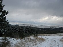
199:Dreiborn Plateau in December 2009
61:Vogelsang Military Training Area
46:Vogelsang Military Training Area
24:and the Kermeter upland forest
1:
298:www.dreiborner-hochflaeche.de
73:, the river and village of
366:
275:Bachem-Verlag, Köln 2006,
257:NRW-Stiftung/Eifelverein:
212:Warning sign near Herhahn
124:Nature, flora and fauna
221:
213:
200:
133:
62:
53:Location and geography
37:
25:
219:
211:
198:
131:
60:
38:Dreiborner Hochfläche
19:
345:Regions of the Eifel
321:50.56333°N 6.41639°E
87:Ordensburg Vogelsang
22:Ordensburg Vogelsang
317: /
42:Eifel National Park
222:
214:
201:
134:
63:
26:
326:50.56333; 6.41639
357:
332:
331:
329:
328:
327:
322:
318:
315:
314:
313:
310:
139:European wildcat
110:Drei-Täler-Blick
30:Dreiborn Plateau
365:
364:
360:
359:
358:
356:
355:
354:
335:
334:
325:
323:
319:
316:
311:
308:
306:
304:
303:
289:
254:
228:Footpaths run:
206:
126:
106:Heilsteinquelle
55:
12:
11:
5:
363:
361:
353:
352:
347:
337:
336:
301:
300:
295:
288:
287:External links
285:
284:
283:
269:
253:
250:
240:
239:
236:
233:
205:
202:
125:
122:
101:to the north.
54:
51:
13:
10:
9:
6:
4:
3:
2:
362:
351:
348:
346:
343:
342:
340:
333:
330:
299:
296:
294:
291:
290:
286:
282:
281:3-7616-2005-5
278:
274:
270:
268:
267:3-7616-1741-0
264:
260:
256:
255:
251:
249:
246:
243:
237:
234:
231:
230:
229:
226:
218:
210:
203:
197:
193:
190:
188:
184:
180:
176:
172:
166:
164:
160:
154:
152:
148:
144:
140:
130:
123:
121:
119:
115:
114:ghost village
111:
107:
102:
100:
96:
92:
88:
84:
80:
76:
72:
68:
59:
52:
50:
47:
43:
39:
35:
31:
23:
18:
302:
272:
258:
247:
244:
241:
227:
223:
191:
169:introducing
167:
155:
135:
109:
105:
103:
64:
29:
27:
324: /
187:fallow deer
151:black stork
91:Urft valley
339:Categories
309:50°33′48″N
252:Literature
147:grey heron
118:Wollseifen
75:Erkensruhr
312:6°24′59″E
175:wild boar
143:cormorant
171:red deer
163:red deer
99:Kermeter
93:and the
79:Dreiborn
204:Tourism
159:Ginster
95:Urftsee
83:Herhahn
71:Einruhr
67:Obersee
279:
265:
34:German
179:bison
277:ISBN
263:ISBN
185:and
173:and
149:and
81:and
69:and
28:The
183:elk
116:of
341::
181:,
145:,
36::
32:(
Text is available under the Creative Commons Attribution-ShareAlike License. Additional terms may apply.