390:
438:
426:
132:
125:
29:
414:
378:
402:
342:, the kings of Bavaria, Bohemia and Austria gathered on the top of the Dreisesselberg, to negotiate the limits of their dominions. In reality, the name Dreisesselberg ("three chairs") was not used until the 17th century, first for the remarkable group of rocks at the summit, but soon the whole mountain. The actual frontier was only fixed in 1765 between the
287:
On the western slopes of the
Dreisesselberg, the Habergrasberg (1,235 m), is the Dreisessel Lift, a ski lift with a base station in Haidmühle-Frauenberg that is no longer in operation. On the Dreisesselberg, on the Bavarian side, is a nature reserve covering about 270 hectares. Those parts of the
279:
There is a road up to the
Dreisesselhaus, so the Dreisselberg is often quite busy. Waymarked hiking trails lead to the summit from all directions, for example, from the Kreuzbachklause, from Haidmühle-Frauenberg or Czech
389:
272:
Approximately 450 metres due south of the
Dreisesselberg's summit is the Dreisesselfels, three bizarre granite rock formations, with pillow-like shaped rocks formed by
307:(1378.3 m). It runs along the German-Czech border and then on the Austria-Czech border. Just below them is on the Czech territory Plöckensteinersee, the southernmost
81:
314:
Especially in winter, the
Dreisesselberg offers views on the Alps. During the good conditions, it is also possible to observe the Grossglockner (206 km away).
437:
276:. Just north of these rocks is the Dreisesselhaus (1,312 m) and the managed mountain inn of Dreisessel. A few metres to the east runs the German-Czech border.
362:(both 1867), a literary monument. His reports of the Dreisesselberg was already a popular destination for hikers. In 1888 the Dreisesselberg branch of the
425:
413:
570:
377:
366:
had built the first refuge hut on the mountain. Next to this hut built in 1913, the current building was erected, which was modernized in the 1960s.
535:
124:
555:
265:
At the highest point of the most heavily forested mountain of
Dreisessel, called Hochstein, is a distinctive granite rock with a
323:
560:
496:
289:
74:
401:
575:
565:
330:(Geotope no.: 272R024). They were awarded the official seal of "Bavaria's most beautiful geotopes" by the LfU.
303:
between
Germany, Austria and the Czech Republic (1,321 m) to the Austro-Czech border on the main summit of the
296:
60:
511:
363:
347:
28:
343:
273:
472:
184:
281:
531:
227:
153:
215:
172:
304:
254:
241:
The Czech border runs some 370 metres southeast of the summit of the
Dreisesselberg. The
250:
165:
549:
148:
226:
The
Dreisesselberg is located in the eastern part of Lower Bavaria in the county of
308:
266:
235:
473:"Unikátní záběry Alp ze Šumavy, výjimečná dohlednost přinesla nádhernou podívanou"
231:
322:
The summit crags with the granites on the
Dreisessel have been designated by the
257:, about 3 kilometres southeast of the Dreisesselberg (as the crow flies).
51:
350:
and surveyed in 1767. As well as mentioning the
Dreisesselberg in his story,
96:
83:
300:
242:
460:
327:
246:
211:
207:
190:
144:
44:
295:
From the Dreisesselberg, a ridge, the Hochkamm, leads across to the
338:
According to a legend, which also Adalbert Stifter describes in
419:
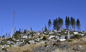
View looking southeast at the bark-beetle damaged woodland
383:
View looking southwest over the sea of fog in the valley
354:, Adalbert Stifter also mentioned it in his last novel,
528:
Der Dreiländerberg: Grenzland Bayern-Böhmen-Österreich
183:
178:
164:
112:
73:
59:
43:
38:
21:
288:eastern slopes on Czech territory are part of the
512:Bayerns schönste Geotope, Granite am Dreisessel
8:
443:View of the Czech side of the Dreisesselberg
18:
497:Bayerisches Landesamt für Umwelt, Geotop
33:View of the summit of the Dreisesselberg
453:
373:
326:(LfU) as a geo-scientifically valuable
230:. It rises southeast of the village of
324:Bavarian Department of the Environment
131:
431:Rock formations on the Dreisesselberg
269:, from which one can enjoy the view.
7:
253:lies not far from the summit of the
14:
571:Mountains of the Bavarian Forest
436:
424:
412:
400:
388:
376:
234:and northeast of the village of
130:
123:
27:
499:Gipfelklippen am Dreisesselberg
1:
502:(retrieved 10 December 2017).
395:Summit cross of the Hochstein
290:Bohemian Forest National Park
50:1,333 m above
514:(retrieved 10 December 2017)
218:that is 1,333 metres high.
592:
556:One-thousanders of Germany
530:. Morsak, Grafenau, 1991,
358:, and in his final story,
66:
360:Aus dem baierischen Walde
117:
26:
311:of the Bohemian Forest.
461:Berggasthof Dreisessel
299:(1,365 m) and via the
407:Bishop Neumann Chapel
297:Bavarian Plöckenstein
97:48.78472°N 13.80250°E
561:Mountains of Bavaria
364:Bavarian Forest Club
348:Archduchy of Austria
344:Bishopric of Passau
274:woolsack weathering
206:) is a mountain in
93: /
16:Mountain in Germany
102:48.78472; 13.80250
39:Highest point
536:978-3-87553-110-7
245:between Germany,
196:
195:
583:
576:Freyung-Grafenau
515:
509:
503:
494:
488:
487:
485:
484:
477:www.in-pocasi.cz
469:
463:
458:
440:
428:
416:
404:
392:
380:
228:Freyung-Grafenau
168:
154:Freyung-Grafenau
134:
133:
127:
108:
107:
105:
104:
103:
98:
94:
91:
90:
89:
86:
68:
54:
31:
19:
591:
590:
586:
585:
584:
582:
581:
580:
566:Bohemian Forest
546:
545:
544:
523:
518:
510:
506:
495:
491:
482:
480:
471:
470:
466:
459:
455:
451:
444:
441:
432:
429:
420:
417:
408:
405:
396:
393:
384:
381:
372:
336:
320:
263:
224:
216:Bavarian Forest
189:coarse-grained
173:Bavarian Forest
166:
160:
159:
158:
157:
156:
152:
142:
141:
140:
139:
135:
101:
99:
95:
92:
87:
84:
82:
80:
79:
55:(4,373 ft)
49:
34:
17:
12:
11:
5:
589:
587:
579:
578:
573:
568:
563:
558:
548:
547:
543:
542:External links
540:
539:
538:
522:
519:
517:
516:
504:
489:
464:
452:
450:
447:
446:
445:
442:
435:
433:
430:
423:
421:
418:
411:
409:
406:
399:
397:
394:
387:
385:
382:
375:
371:
368:
335:
332:
319:
316:
262:
259:
251:Czech Republic
223:
220:
200:Dreisesselberg
194:
193:
187:
181:
180:
176:
175:
170:
162:
161:
143:
138:Dreisesselberg
137:
136:
129:
128:
122:
121:
120:
119:
118:
115:
114:
110:
109:
77:
71:
70:
69:Mountain ridge
63:
57:
56:
52:sea level (NN)
47:
41:
40:
36:
35:
32:
24:
23:
22:Dreisesselberg
15:
13:
10:
9:
6:
4:
3:
2:
588:
577:
574:
572:
569:
567:
564:
562:
559:
557:
554:
553:
551:
541:
537:
533:
529:
525:
524:
520:
513:
508:
505:
501:
500:
493:
490:
478:
474:
468:
465:
462:
457:
454:
448:
439:
434:
427:
422:
415:
410:
403:
398:
391:
386:
379:
374:
369:
367:
365:
361:
357:
353:
349:
345:
341:
333:
331:
329:
325:
317:
315:
312:
310:
306:
302:
298:
293:
291:
285:
283:
277:
275:
270:
268:
260:
258:
256:
252:
248:
244:
239:
237:
233:
229:
221:
219:
217:
213:
209:
205:
201:
192:
188:
186:
182:
177:
174:
171:
169:
163:
155:
150:
149:Lower Bavaria
146:
126:
116:
111:
106:
78:
76:
72:
64:
62:
58:
53:
48:
46:
42:
37:
30:
25:
20:
527:
526:Paul Praxl:
507:
498:
492:
481:. Retrieved
476:
467:
456:
359:
355:
351:
339:
337:
321:
318:Summit crags
313:
309:glacial lake
305:Plöckenstein
294:
286:
278:
271:
267:summit cross
264:
255:Plöckenstein
240:
236:Neureichenau
225:
204:Třístoličník
203:
199:
197:
185:Type of rock
167:Parent range
261:Description
100: /
75:Coordinates
65:1.1 km
550:Categories
521:Literature
483:2023-01-09
479:(in Czech)
449:References
282:Nové Údolí
232:Haidmühle
214:, in the
113:Geography
88:13°48′9″E
85:48°47′5″N
61:Isolation
45:Elevation
352:Hochwald
340:Hochwald
301:tripoint
249:and the
243:tripoint
222:Location
202:(Czech:
370:Gallery
334:History
328:geotope
247:Austria
212:Germany
208:Bavaria
191:granite
179:Geology
145:Bavaria
67:→
534:
356:Witiko
532:ISBN
346:and
198:The
552::
475:.
292:.
284:.
238:.
210:,
147:,
486:.
151:,
Text is available under the Creative Commons Attribution-ShareAlike License. Additional terms may apply.