66:
50:
454:
73:
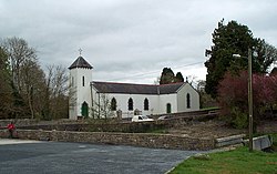
269:. The village consists of St. Bridget's National School, also known as Drumcong Central School, St. Brigid's Church, burial grounds, and two businesses. St. Brigid's Church, of Roman Catholic denomination, is a barn church which was restored after falling into disuse for two decades.
272:
The
Lakeside Tavern, a pub and shop, is owned and operated by James and Eilis Cardiff. Drumcong is classed as a Tier 4 Village in Leitrim County Council's Development Plan 2009–2015.
375:
289:
313:
O'Donovan's Name Books (Kiltubrid) Parish
Compiled by John O'Donovan in 1835. Re-arranged and re-typed by FAS Project in Leitrim Genealogy Centre, Ballinamore in 1994.
500:
411:
458:
97:
386:
347:
217:
49:
65:
275:
The village of
Drumcong developed around Kiltubrid Railway Station, which opened on 16 June 1885 and closed on 18 October 1958.
466:
203:
211:
431:
188:
137:
266:
199:
149:
262:
246:
178:
405:
238:
230:
154:
494:
474:
258:
284:
242:
112:
99:
169:
453:
142:
237:, meaning 'Ridge of the Cong, a narrow neck or strait') is a village in
174:
361:
195:
210:
185:
168:
160:
148:
136:
128:
26:
334:
8:
31:
23:
467:"Drumcong jamboree and dancing carnival"
439:. Vol. v.3. Dublin : Phoenix.
306:
209:
167:
159:
127:
92:
58:
46:
430:Joyce, P. W. (Patrick Weston) (1913).
410:: CS1 maint: archived copy as title (
403:
322:
290:List of towns and villages in Ireland
184:
147:
135:
7:
501:Towns and villages in County Leitrim
54:St. Brigid's R.C. Church in Drumcong
16:Village in County Leitrim, Ireland
14:
459:Drumcong, County Leitrim, Ireland
452:
72:
71:
64:
48:
1:
21:Village in Connacht, Ireland
241:, Ireland, located between
517:
465:Leitrim Observer (1970).
93:
59:
47:
40:
30:
164:69 m (226 ft)
348:"Citizens Information"
234:
32:
433:Irish names of places
362:"The Lakeside Tavern"
335:Leitrim Observer 1970
187: • Summer (
461:at Wikimedia Commons
296:Notes and references
257:Drumcong is between
212:Irish Grid Reference
109: /
85:Location in Ireland
477:on 2 February 2017
392:on 2 December 2013
383:www.leitrimcoco.ie
263:Carrick-on-Shannon
247:Carrickaport Lough
113:54.0281°N 7.9722°W
457:Media related to
423:Secondary sources
224:
223:
508:
486:
484:
482:
473:. Archived from
471:Leitrim Observer
456:
440:
438:
416:
415:
409:
401:
399:
397:
391:
385:. Archived from
380:
372:
366:
365:
358:
352:
351:
344:
338:
332:
326:
320:
314:
311:
220:
192:
124:
123:
121:
120:
119:
118:54.0281; -7.9722
114:
110:
107:
106:
105:
102:
75:
74:
68:
52:
35:
24:
516:
515:
511:
510:
509:
507:
506:
505:
491:
490:
489:
480:
478:
464:
448:
443:
436:
429:
425:
420:
419:
402:
395:
393:
389:
378:
376:"Archived copy"
374:
373:
369:
360:
359:
355:
346:
345:
341:
333:
329:
325:, pp. 319.
321:
317:
312:
308:
303:
301:Primary sources
298:
281:
255:
216:
186:
117:
115:
111:
108:
103:
100:
98:
96:
95:
89:
88:
87:
86:
83:
82:
81:
80:
76:
55:
43:
36:
29:
22:
17:
12:
11:
5:
514:
512:
504:
503:
493:
492:
488:
487:
462:
449:
447:
446:External links
444:
442:
441:
426:
424:
421:
418:
417:
367:
353:
339:
327:
315:
305:
304:
302:
299:
297:
294:
293:
292:
287:
280:
277:
254:
251:
239:County Leitrim
222:
221:
214:
208:
207:
193:
183:
182:
172:
166:
165:
162:
158:
157:
155:County Leitrim
152:
146:
145:
140:
134:
133:
130:
126:
125:
91:
90:
84:
78:
77:
70:
69:
63:
62:
61:
60:
57:
56:
53:
45:
44:
41:
38:
37:
27:
20:
15:
13:
10:
9:
6:
4:
3:
2:
513:
502:
499:
498:
496:
476:
472:
468:
463:
460:
455:
451:
450:
445:
435:
434:
428:
427:
422:
413:
407:
388:
384:
377:
371:
368:
363:
357:
354:
349:
343:
340:
337:, pp. 3.
336:
331:
328:
324:
319:
316:
310:
307:
300:
295:
291:
288:
286:
283:
282:
278:
276:
273:
270:
268:
264:
260:
252:
250:
248:
244:
240:
236:
232:
228:
219:
215:
213:
205:
201:
197:
194:
190:
180:
176:
173:
171:
163:
156:
153:
151:
144:
141:
139:
131:
122:
94:Coordinates:
67:
51:
39:
34:
25:
19:
479:. Retrieved
475:the original
470:
432:
394:. Retrieved
387:the original
382:
370:
356:
342:
330:
318:
309:
274:
271:
256:
226:
225:
18:
259:Ballinamore
235:Droim Conga
116: /
33:Droim Conga
481:29 January
396:13 January
323:Joyce 1913
285:Kiltubbrid
243:Lough Scur
101:54°01′41″N
267:R208 road
170:Time zone
161:Elevation
104:7°58′20″W
495:Category
406:cite web
279:See also
253:Overview
227:Drumcong
143:Connacht
138:Province
79:Drumcong
28:Drumcong
265:on the
218:H018087
132:Ireland
129:Country
42:Village
150:County
437:(PDF)
390:(PDF)
379:(PDF)
231:Irish
196:UTC-1
175:UTC+0
483:2017
412:link
398:2022
261:and
245:and
204:WEST
200:IST
189:DST
179:WET
497::
469:.
408:}}
404:{{
381:.
249:.
233::
206:))
485:.
414:)
400:.
364:.
350:.
229:(
202:(
198:(
191:)
181:)
177:(
Text is available under the Creative Commons Attribution-ShareAlike License. Additional terms may apply.