451:. Hill of Drumclogg and Laigh Crumclogg are shown together some un-named buildings and with Snaid recorded on the predecessor to the A71, the Ayr to Edinburgh by Haamilton and Kirk of Shotts Road. Ross's 1773 map shows Drumclog to the north of the Ayr to Edinburgh road with the inaccurate note 'Clevers fought a battle 1684'. In 1816 Forrest's map shows East, High and Laigh Drumclog together with Snabe (sic). Both coal and limeworks are shown. In 1822 lime and coal works are still shown. The 1858 OS map shows old limestone quarries and a number of old limekilns. The 1911 OS map shows the presence of a post office, the church and Drumclog railway station. In 1958 the OS map shows the railway to have been closed and lifted.
383:
65:
286:
49:
429:
466:
72:
158:
390:
The Old
Memorial School was located away from the centre of the village in a location that was most convenient for the farms and their children. The plaque on the wall reads "On the battlefield of Drumclog, this Seminary of Education was erected, in memory of those Christian Heroes, who on Sabath the
373:
that was fought nearby in 1679 when the
Covenanters defeated Government troops. The original remembrance stone for this battle, damaged by a lightning strike, stands on the west side of the kirk. The stone's inscription reads "In commemoration of the victory obtained on this battlefield, on Sabbath
411:
serving a rural area that included the village and farms in the rural area around
Drumclog. The line had been intended as a through route between Lanarkshire and Ayrshire, however there was very little traffic along the route as the population in the area was very low. The station was closed from
368:
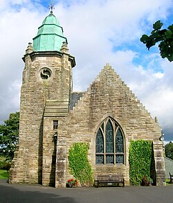
This church was opened in 1912 and replaced a corrugated-iron church that had been built in 1901 to serve this remote location in
Avendale and Drumclog Parish. It was designed by J McLellan Fairley in a Gothic-style with a square tower crowned with an octagonal copper covered spire. The title
321:
Originally the village was a group of small farms however the opening of the railway in 1905 and the building of a substantial stone church in 1912 created a focus upon the area around Snabe and the habitation then formally achieved the status of a named village.
305:
defeated the King's
Dragoons who were under the command of Claverhouse. The Lochgoin Covenanters Museum on Whitelee Moor in Fenwick Parish has displays and artifacts from the battle. A monument is located on the site of the battle.
374:
the 11th June 1679, by our
Covenanted forefathers over Graham of Claverhouse and his dragoons." A stained glass window of the battle is a further commemoration together with a replica of the Covenanter's Flag.
541:
817:
412:
September until
November 1909 and then again from January 1917 until December 1922. The last train ran on 10 September 1939, however the official closing date was two weeks later.
182:
618:[Adair, John, ca. 1650-1722 Title: A mape of the west of Scotland containing Clydsdail, Nithsdail, Ranfrew, Shyre of Ayre, & Galloway / authore Jo. Adair.]
552:
310:
visited the battlefield in April 1820 and wrote a description of the "flat wilderness of broken bog, a quagmire not to be trusted". At the nearby hamlet of
103:
64:
827:
822:
783:
742:
352:), in place names meaning a standing stone or other stones of perceived significance. The second part of the name could also be the cognate
730:
The
Directory of Railway Stations: details every public and private passenger station, halt, platform and stopping place, past and present
382:
221:
170:
608:
Glottiana
Praefectura Inferior, cum Baronia Glascuensi, [vulgo], The nether ward of Clyds-dail and Glasco / Auct. Timoth. Pont.
206:
175:
627:
130:
391:
1st of June 1679 nobly fought, in defence of Civil and
Religious Liberty". The nearest primary school is now at Gilmourton.
404:
318:
is located that is named after a government soldier who was killed and buried at the site in the aftermath of the battle.
96:
459:
In 1803 a buried hoard of Roman coins was unearthed at North Torfoot Farm. In 1848 a Drumclog Tile Works was recorded.
443:
circa 1560 to 1614 shows an 'O. Drumclogs' and a 'N. Drumklog'. Adair's 1685 map shows Drumclog close to a track from
413:
211:
187:
661:
Thomson, John, 1777- ca. 1840 Johnson, William, fl. 1806-1840 Title: Northern Part of Lanarkshire. Southern Part.
28:
400:
144:
112:
417:
697:
NS63NW - A (includes: Avondale; Galston; Loudoun) Surveyed / Revised: Pre-1930 to 1957. Published: 1958
576:
496:
315:
408:
370:
294:
779:
748:
738:
258:
120:
85:
334:
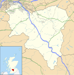
261:, Parish of Avendale and Drumclog, Scotland. The habitation is situated on the A71, between
17:
756:
471:
353:
285:
163:
48:
802:
707:
507:
346:
307:
596:
428:
811:
298:
270:
724:
444:
440:
325:
The post office has closed however the church remains in regular use (datum 2019).
728:
650:
Forrest, William, fl. 1799-1832 Title: The county of Lanark from actual survey.
797:
461:
436:
311:
302:
274:
266:
262:
660:
236:
223:
760:
752:
734:
136:
448:
672:
Lanarkshire XXX.9 (Avondale) Survey date: 1858. Publication date: 1860
696:
682:
671:
649:
638:
607:
341:, indicating a place with "a back, a ridge", and the second element
683:
Lanarkshire XXX.9 (Avondale) Publication date: 1911. Revised: 1909.
337:
origins. The first part of the name may be the very common element
381:
284:
639:
Ross, Charles, 1722-1806 Title: A map of the shire of Lanark.
369:"Drumclog Memorial Kirk" was given in remembrance of the
27:
This article is about the village. For other uses, see
420:
to the east. A photograph can be found at this site.
399:
Located at NS 63889 38645 next to the A71 this was a
628:
1747-55 - William ROY - Military Survey of Scotland
181:
169:
157:
143:
129:
111:
95:
41:
803:Video footage of the Lochgoin Covenanters Museum
273:at a height of 196.7m and about 5 miles west of
293:Drumclog is best known as the site of the 1679
549:SPNS - The Brittonic Language in the Old North
289:The original Battle of Drumclog memorial stone
818:Buildings and structures in South Lanarkshire
771:. Edinburgh : T.C.Jack Publishing Works.
8:
692:
690:
38:
517:
515:
535:
533:
531:
529:
527:
427:
798:Video footage of Drumclog Memorial Kirk
708:Scotland's Brick Manufacturing Industry
597:Canmore : Drumclog railway station
489:
152:
128:
94:
45:
432:The site of Drumclog railway station.
180:
168:
156:
142:
110:
7:
542:"A Guide to the Place-Name Evidence"
577:Avondale and Drumclog Parish Church
345:, "a rock, a crag, a steep cliff" (
25:
508:Canmore : Battle of Drumclog
464:
386:The old Drumclog Memorial School
71:
70:
63:
47:
769:Ordnance Gazetteer of Scotland
1:
828:Villages in South Lanarkshire
405:Darvel and Strathaven Railway
823:History of South Lanarkshire
776:Lanarkshire's Lost Railways.
36:Human settlement in Scotland
778:Ochiltree : Stenlake.
774:Stansfield, Gordon (1997).
767:Groome, Francis H. (1886).
497:Lochgoin Covenanters Museum
414:Loudounhill railway station
97:OS grid reference
18:Drumclog, South Lanarkshire
844:
407:opened 4 July 1905 by the
237:55.62450027°N 4.16179877°W
26:
521:Groome, Vol. II. Page 372
197:
193:
153:
58:
46:
29:Drumclog (disambiguation)
737:: Patrick Stephens Ltd.
439:'s map based on that of
395:Drumclog railway station
378:Drumclog Memorial School
242:55.62450027; -4.16179877
418:Ryeland railway station
433:
416:stood to the west and
387:
364:Drumclog Memorial Kirk
290:
257:is a small village in
53:Drumclog Memorial Kirk
431:
424:Cartographic evidence
385:
288:
145:Sovereign state
587:Stansfield, Page 32
297:that took place on
233: /
434:
409:Caledonian Railway
388:
371:Battle of Drumclog
333:Drumclog may have
295:Battle of Drumclog
291:
784:978-1-872074-96-2
744:978-1-85260-508-7
558:on 13 August 2017
259:South Lanarkshire
252:
251:
121:South Lanarkshire
113:Council area
86:South Lanarkshire
16:(Redirected from
835:
764:
733:(1st ed.).
727:(October 1995).
710:
705:
699:
694:
685:
680:
674:
669:
663:
658:
652:
647:
641:
636:
630:
625:
619:
616:
610:
605:
599:
594:
588:
585:
579:
574:
568:
567:
565:
563:
557:
551:. Archived from
546:
537:
522:
519:
510:
505:
499:
494:
474:
469:
468:
467:
316:Trumpeter's Well
248:
247:
245:
244:
243:
238:
234:
231:
230:
229:
226:
203:
139:
107:
106:
84:Location within
74:
73:
67:
51:
39:
21:
843:
842:
838:
837:
836:
834:
833:
832:
808:
807:
794:
789:
745:
723:
714:
713:
706:
702:
695:
688:
681:
677:
670:
666:
659:
655:
648:
644:
637:
633:
626:
622:
617:
613:
606:
602:
595:
591:
586:
582:
575:
571:
561:
559:
555:
544:
539:
538:
525:
520:
513:
506:
502:
495:
491:
481:
472:Scotland portal
470:
465:
463:
457:
426:
401:railway station
397:
380:
366:
331:
283:
241:
239:
235:
232:
227:
224:
222:
220:
219:
218:
201:
135:
125:
102:
101:
91:
90:
89:
88:
82:
81:
80:
79:
75:
54:
37:
32:
23:
22:
15:
12:
11:
5:
841:
839:
831:
830:
825:
820:
810:
809:
806:
805:
800:
793:
792:External links
790:
788:
787:
772:
765:
743:
725:Butt, R. V. J.
720:
719:
718:
712:
711:
700:
686:
675:
664:
653:
642:
631:
620:
611:
600:
589:
580:
569:
523:
511:
500:
488:
487:
486:
485:
480:
477:
476:
475:
456:
453:
425:
422:
396:
393:
379:
376:
365:
362:
330:
327:
308:Thomas Carlyle
282:
279:
250:
249:
217:
216:
214:
209:
204:
202:List of places
198:
195:
194:
191:
190:
185:
179:
178:
173:
167:
166:
161:
155:
154:
151:
150:
149:United Kingdom
147:
141:
140:
133:
127:
126:
124:
123:
117:
115:
109:
108:
99:
93:
92:
83:
77:
76:
69:
68:
62:
61:
60:
59:
56:
55:
52:
44:
43:
35:
24:
14:
13:
10:
9:
6:
4:
3:
2:
840:
829:
826:
824:
821:
819:
816:
815:
813:
804:
801:
799:
796:
795:
791:
785:
781:
777:
773:
770:
766:
762:
758:
754:
750:
746:
740:
736:
732:
731:
726:
722:
721:
716:
715:
709:
704:
701:
698:
693:
691:
687:
684:
679:
676:
673:
668:
665:
662:
657:
654:
651:
646:
643:
640:
635:
632:
629:
624:
621:
615:
612:
609:
604:
601:
598:
593:
590:
584:
581:
578:
573:
570:
554:
550:
543:
540:James, Alan.
536:
534:
532:
530:
528:
524:
518:
516:
512:
509:
504:
501:
498:
493:
490:
483:
482:
478:
473:
462:
460:
454:
452:
450:
446:
442:
438:
430:
423:
421:
419:
415:
410:
406:
402:
394:
392:
384:
377:
375:
372:
363:
361:
359:
355:
351:
348:
344:
340:
336:
328:
326:
323:
319:
317:
313:
309:
304:
301:in which the
300:
299:Drumclog Moss
296:
287:
280:
278:
276:
272:
271:East Ayrshire
268:
264:
260:
256:
246:
215:
213:
210:
208:
205:
200:
199:
196:
192:
189:
186:
184:
177:
174:
172:
165:
162:
160:
148:
146:
138:
134:
132:
122:
119:
118:
116:
114:
105:
100:
98:
87:
66:
57:
50:
40:
34:
30:
19:
775:
768:
729:
703:
678:
667:
656:
645:
634:
623:
614:
603:
592:
583:
572:
560:. Retrieved
553:the original
548:
503:
492:
458:
445:Loudoun Hill
441:Timothy Pont
435:
398:
389:
367:
357:
349:
342:
338:
332:
324:
320:
292:
254:
253:
104:NS 6397 3888
33:
562:25 November
455:Archaeology
303:Covenanters
240: /
812:Categories
479:References
437:Joan Blaeu
312:Caldermill
275:Strathaven
267:Priestland
263:Caldermill
225:55°37′28″N
761:11956311M
735:Sparkford
350:drum-clog
335:Brittonic
329:Etymology
228:4°09′42″W
183:Ambulance
753:60251199
356:element
255:Drumclog
212:Scotland
188:Scottish
176:Scottish
164:Scotland
137:Scotland
78:Drumclog
42:Drumclog
717:Sources
449:Renfrew
403:on the
281:History
131:Country
782:
759:
751:
741:
354:Gaelic
159:Police
556:(PDF)
545:(PDF)
484:Notes
358:clach
347:Welsh
343:*clog
339:*drum
780:ISBN
749:OCLC
739:ISBN
564:2018
314:the
265:and
171:Fire
447:to
269:in
814::
757:OL
755:.
747:.
689:^
547:.
526:^
514:^
360:.
277:.
207:UK
786:.
763:.
566:.
31:.
20:)
Text is available under the Creative Commons Attribution-ShareAlike License. Additional terms may apply.