141:
181:
148:
411:
425:
174:
29:
332:
in 1910 when viewing two broad rock scars near the summit, and their arrangement in connection with the surrounding snow created the appearance of enormous eyebrows. However, using the same sightings as
Wheeler, Professor Peter Robinson showed that Wheeler actually saw
140:
642:
96:
328:
of the mountain was made in 1914 by Edward Warren
Harnden, D. Brown, L. Nettleton, and E. Parson via the west slopes. The name Eyebrow Peak came about by
361:
zone with cold, snowy winters, and mild summers. Temperatures can drop below −20 °C with wind chill factors below −30 °C. Precipitation
82:
342:
249:
354:
652:
621:
317:
252:
173:
590:
Peel, M. C.; Finlayson, B. L. & McMahon, T. A. (2007). "Updated world map of the Köppen−Geiger climate classification".
438:
89:
443:
246:
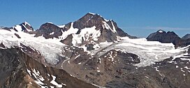
647:
512:
341:
moniker was then moved to its present location. The mountain's name was officially adopted June 9, 1960, by the
517:
386:
281:
220:
64:
54:
569:
329:
507:
321:
77:
69:
304:. It is the ninth-highest peak in the Purcells. It is situated 28 km (17 mi) south of
599:
358:
293:
234:
416:
297:
210:
241:
369:
from its surrounding glaciers drains into
Horsethief Creek, which is a tributary of the
370:
362:
227:
636:
564:
430:
334:
325:
313:
305:
274:
264:
292:
is a prominent 3,362-metre (11,030-foot) glaciated mountain summit located in the
28:
540:
478:
406:
603:
111:
98:
366:
309:
627:
301:
44:
337:. Poor weather conditions led to Wheeler's error, and the
324:, 11.4 km (7.1 mi) to the southeast. The
273:
263:
258:
240:
226:
216:
206:
127:
88:
76:
63:
53:
43:
38:
21:
381:Established climbing routes on Eyebrow Peak:
8:
160:Location of Eyebrow Peak in British Columbia
18:
473:
471:
469:
467:
465:
463:
461:
459:
312:, 6 km (3.7 mi) north of
502:
500:
498:
455:
316:, and 18 km (11 mi) east of
269:1914 Brown, Harnden, Nettleton, Parson
643:Three-thousanders of British Columbia
7:
535:
533:
180:
147:
392:Southwest Face - First ascent 1928
343:Geographical Names Board of Canada
308:, 44 km (27 mi) west of
14:
16:Mountain in the country of Canada
541:"Eyebrow Peak, British Columbia"
423:
409:
179:
172:
146:
139:
27:
398:South Ridge - First ascent 1928
357:, Eyebrow Peak is located in a
1:
439:Geography of British Columbia
395:West Face - First ascent 1928
355:Köppen climate classification
320:. Its nearest higher peak is
83:Mountains of British Columbia
49:3,362 m (11,030 ft)
513:Geographical Names Data Base
163:Show map of British Columbia
626:Eyebrow Peak aerial photo:
444:Geology of British Columbia
669:
59:901 m (2,956 ft)
33:Eyebrow Peak, south aspect
132:
26:
518:Natural Resources Canada
211:British Columbia, Canada
592:Hydrol. Earth Syst. Sci
653:Kootenay Land District
365:from Eyebrow Peak and
221:Kootenay Land District
112:50.48250°N 116.68139°W
570:BC Geographical Names
330:Arthur Oliver Wheeler
193:Eyebrow Peak (Canada)
117:50.48250; -116.68139
108: /
322:Commander Mountain
196:Show map of Canada
70:Commander Mountain
39:Highest point
648:Purcell Mountains
389:First ascent 1914
359:subarctic climate
294:Purcell Mountains
287:
286:
235:Purcell Mountains
660:
608:
607:
587:
581:
580:
578:
577:
561:
555:
554:
552:
551:
537:
528:
527:
525:
524:
504:
493:
492:
490:
489:
475:
433:
428:
427:
426:
419:
417:Mountains portal
414:
413:
412:
298:British Columbia
277:
230:
197:
183:
182:
176:
164:
150:
149:
143:
123:
122:
120:
119:
118:
113:
109:
106:
105:
104:
101:
31:
19:
668:
667:
663:
662:
661:
659:
658:
657:
633:
632:
617:
612:
611:
589:
588:
584:
575:
573:
563:
562:
558:
549:
547:
539:
538:
531:
522:
520:
506:
505:
496:
487:
485:
477:
476:
457:
452:
429:
424:
422:
415:
410:
408:
405:
379:
377:Climbing Routes
351:
275:
228:
202:
201:
200:
199:
198:
195:
194:
191:
190:
189:
188:
184:
167:
166:
165:
162:
161:
158:
157:
156:
155:
151:
116:
114:
110:
107:
102:
99:
97:
95:
94:
34:
17:
12:
11:
5:
666:
664:
656:
655:
650:
645:
635:
634:
631:
630:
624:
616:
615:External links
613:
610:
609:
582:
565:"Eyebrow Peak"
556:
545:Peakbagger.com
529:
508:"Eyebrow Peak"
494:
479:"Eyebrow Peak"
454:
453:
451:
448:
447:
446:
441:
435:
434:
420:
404:
401:
400:
399:
396:
393:
390:
385:West Slopes -
378:
375:
371:Columbia River
350:
347:
285:
284:
279:
271:
270:
267:
261:
260:
256:
255:
244:
238:
237:
232:
224:
223:
218:
214:
213:
208:
204:
203:
192:
186:
185:
178:
177:
171:
170:
169:
168:
159:
153:
152:
145:
144:
138:
137:
136:
135:
134:
133:
130:
129:
125:
124:
92:
86:
85:
80:
74:
73:
67:
61:
60:
57:
51:
50:
47:
41:
40:
36:
35:
32:
24:
23:
15:
13:
10:
9:
6:
4:
3:
2:
665:
654:
651:
649:
646:
644:
641:
640:
638:
629:
625:
623:
619:
618:
614:
605:
601:
597:
593:
586:
583:
572:
571:
566:
560:
557:
546:
542:
536:
534:
530:
519:
515:
514:
509:
503:
501:
499:
495:
484:
480:
474:
472:
470:
468:
466:
464:
462:
460:
456:
449:
445:
442:
440:
437:
436:
432:
431:Canada portal
421:
418:
407:
402:
397:
394:
391:
388:
384:
383:
382:
376:
374:
372:
368:
364:
360:
356:
353:Based on the
348:
346:
344:
340:
336:
335:Mount Farnham
331:
327:
323:
319:
315:
311:
307:
303:
299:
296:in southeast
295:
291:
283:
280:
278:
276:Easiest route
272:
268:
266:
262:
257:
254:
251:
248:
245:
243:
239:
236:
233:
231:
225:
222:
219:
215:
212:
209:
205:
175:
142:
131:
126:
121:
93:
91:
87:
84:
81:
79:
75:
72:(3371 m)
71:
68:
66:
62:
58:
56:
52:
48:
46:
42:
37:
30:
25:
20:
622:Eyebrow Peak
595:
591:
585:
574:. Retrieved
568:
559:
548:. Retrieved
544:
521:. Retrieved
511:
486:. Retrieved
482:
387:class 3
380:
352:
338:
326:first ascent
314:Mount Monica
306:The Bugaboos
290:Eyebrow Peak
289:
288:
282:class 3
265:First ascent
229:Parent range
187:Eyebrow Peak
154:Eyebrow Peak
22:Eyebrow Peak
483:Bivouac.com
318:Duncan Lake
253:Duncan Lake
115: /
103:116°40′53″W
90:Coordinates
65:Parent peak
637:Categories
576:2021-05-04
550:2019-12-30
523:2019-12-30
488:2019-12-30
450:References
100:50°28′57″N
55:Prominence
620:Weather:
604:1027-5606
367:meltwater
310:Invermere
128:Geography
45:Elevation
403:See also
259:Climbing
242:Topo map
217:District
207:Location
349:Climate
339:Eyebrow
78:Listing
602:
363:runoff
302:Canada
628:PBase
600:ISSN
250:82K7
247:NTS
639::
598:.
596:11
594:.
567:.
543:.
532:^
516:.
510:.
497:^
481:.
458:^
373:.
345:.
300:,
606:.
579:.
553:.
526:.
491:.
Text is available under the Creative Commons Attribution-ShareAlike License. Additional terms may apply.