219:
207:
36:
302:
The east branch rises out of Beaver Pond about five miles east of
Phoenix. It flows west along the south side of the Cliff Range, paralleled by US 41. The only significant tributary of the east branch is Buffalo Creek, which enters about three miles east of Phoenix.
298:
about a mile and a quarter southeast of
Phoenix. The only significant tributary on the west branch is Brodie Creek, which rises a bit further inland from the Cliff Range and enters the west branch just outside Phoenix.
285:
The east and west branches each run along the south side of the Cliff Range to meet in
Phoenix and flow through a gap in the Cliff Range. The west branch rises about three miles southwest of Phoenix in northeastern
418:
428:
168:
399:
98:
17:
423:
268:
274:
The main branch of the river is formed at the confluence of its East Branch and its West Branch at the community of
349:
287:
291:
376:
365:
334:
312:
295:
279:
264:
231:
150:
41:
248:
395:
275:
218:
353:
412:
260:
154:
57:
345:
U.S. Geological Survey. National
Hydrography Dataset high-resolution flowline data.
35:
377:
U.S. Geological Survey
Geographic Names Information System: West Branch Eagle River
366:
U.S. Geological Survey
Geographic Names Information System: East Branch Eagle River
206:
134:
252:
183:
170:
113:
100:
346:
256:
387:
335:
U.S. Geological Survey
Geographic Names Information System: Eagle River
244:
290:. Cliff Drive runs alongside the river, and is joined by
278:, about two miles southeast of its mouth, and parallels
160:
143:
133:
90:
80:
72:
63:
53:
48:
40:The Eagle River near its mouth in the community of
28:
8:
86:at the confluence of its East and West Forks
324:
330:
328:
25:
7:
419:Rivers of Keweenaw County, Michigan
14:
243:is a 2.6-mile-long (4.2 km)
267:. Most of the river lies within
217:
205:
34:
282:from Phoenix into Eagle River.
392:Michigan Atlas & Gazetteer
162: • coordinates
92: • coordinates
1:
394:. Yarmouth, Maine: Delore.
64:Physical characteristics
429:Tributaries of Lake Superior
230:Falls of the Eagle River in
18:Eagle River (disambiguation)
356:, accessed February 3, 2012
145: • location
82: • location
445:
23:River in the United States
15:
129:
68:
33:
259:. The river flows into
313:List of Michigan rivers
184:47.41500°N 88.29917°W
151:Eagle River, Michigan
114:47.38917°N 88.27833°W
263:in the community of
16:For other uses, see
189:47.41500; -88.29917
180: /
119:47.38917; -88.27833
110: /
424:Rivers of Michigan
352:2012-03-29 at the
249:Keweenaw Peninsula
269:Houghton Township
212:Near minimum flow
199:
198:
436:
403:
385:
379:
374:
368:
363:
357:
347:The National Map
343:
337:
332:
288:Allouez Township
221:
209:
195:
194:
192:
191:
190:
185:
181:
178:
177:
176:
173:
125:
124:
122:
121:
120:
115:
111:
108:
107:
106:
103:
93:
83:
38:
26:
444:
443:
439:
438:
437:
435:
434:
433:
409:
408:
407:
406:
386:
382:
375:
371:
364:
360:
354:Wayback Machine
344:
340:
333:
326:
321:
309:
292:U.S. Highway 41
237:
236:
235:
234:
227:
226:
225:
222:
214:
213:
210:
188:
186:
182:
179:
174:
171:
169:
167:
166:
163:
146:
118:
116:
112:
109:
104:
101:
99:
97:
96:
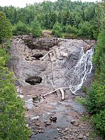
91:
81:
44:
24:
21:
12:
11:
5:
442:
440:
432:
431:
426:
421:
411:
410:
405:
404:
380:
369:
358:
338:
323:
322:
320:
317:
316:
315:
308:
305:
229:
228:
224:Near peak flow
223:
216:
215:
211:
204:
203:
202:
201:
200:
197:
196:
164:
161:
158:
157:
147:
144:
141:
140:
137:
131:
130:
127:
126:
94:
88:
87:
84:
78:
77:
74:
70:
69:
66:
65:
61:
60:
55:
51:
50:
46:
45:
39:
31:
30:
22:
13:
10:
9:
6:
4:
3:
2:
441:
430:
427:
425:
422:
420:
417:
416:
414:
401:
400:0-89933-335-4
397:
393:
389:
384:
381:
378:
373:
370:
367:
362:
359:
355:
351:
348:
342:
339:
336:
331:
329:
325:
318:
314:
311:
310:
306:
304:
300:
297:
293:
289:
283:
281:
277:
272:
270:
266:
262:
261:Lake Superior
258:
254:
250:
246:
242:
233:
220:
208:
193:
165:
159:
156:
155:Lake Superior
152:
148:
142:
138:
136:
132:
128:
123:
95:
89:
85:
79:
75:
71:
67:
62:
59:
58:United States
56:
52:
47:
43:
37:
32:
27:
19:
391:
383:
372:
361:
341:
301:
284:
273:
240:
238:
265:Eagle River
241:Eagle River
232:Eagle River
187: /
117: /
42:Eagle River
29:Eagle River
413:Categories
319:References
253:U.S. state
175:88°17′57″W
172:47°24′54″N
105:88°16′42″W
102:47°23′21″N
390:(2003).
350:Archived
307:See also
257:Michigan
49:Location
388:DeLorme
276:Phoenix
251:of the
247:on the
54:Country
398:
245:stream
139:
76:
73:Source
153:, at
135:Mouth
396:ISBN
296:M-26
294:and
280:M-26
239:The
255:of
149:in
415::
327:^
271:.
402:.
20:.
Text is available under the Creative Commons Attribution-ShareAlike License. Additional terms may apply.