65:
53:
77:
639:
174:
404:
In the township the population was spread out, with 22.2% under the age of 18, 5.2% from 18 to 24, 29.6% from 25 to 44, 28.9% from 45 to 64, and 14.1% who were 65 years of age or older. The median age was 41 years. For every 100 females, there were 100.0 males. For every 100 females age 18 and over,
400:
living together, 6.0% had a female householder with no husband present, and 21.0% were non-families. 18.7% of all households were made up of individuals, and 9.0% had someone living alone who was 65 years of age or older. The average household size was 2.57 and the average family size was 2.91.
372:
of 2000, there were 686 people, 267 households, and 210 families residing in the township. The population density was 57.8 inhabitants per square mile (22.3/km). There were 301 housing units at an average density of 25.4/sq mi (9.8/km). The racial makeup of the township was 99.56%
64:
1034:
740:
52:
572:
760:
810:
770:
765:
1073:
820:
408:
The median income for a household in the township was $ 32,500, and the median income for a family was $ 38,594. Males had a median income of $ 30,481 versus $ 17,500 for females. The
730:
76:
745:
750:
755:
795:
725:
565:
697:
948:
868:
558:
830:
243:
815:
825:
775:
582:
262:
114:
17:
550:
1078:
790:
432:
206:
109:
878:
800:
462:
805:
785:
378:
835:
780:
687:
667:
21:
1011:
958:
534:
282:
883:
682:
672:
270:
988:
943:
893:
702:
334:
319:
888:
707:
231:
87:
963:
923:
918:
898:
845:
717:
692:
396:
There were 267 households, out of which 29.2% had children under the age of 18 living with them, 69.7% were
258:
43:
953:
873:
858:
662:
649:
623:
386:
983:
978:
973:
908:
903:
657:
628:
604:
1018:
993:
913:
863:
677:
390:
216:
998:
968:
933:
853:
615:
382:
374:
412:
for the township was $ 15,345. About 11.0% of families and 11.8% of the population were below the
508:
482:
409:
494:
1067:
236:
413:
266:
102:
597:
285:, the township has a total area of 11.9 square miles (31 km), all land.
97:
1049:
1036:
69:
Map of
Northumberland County, Pennsylvania highlighting East Cameron Township
197:
416:, including 14.9% of those under age 18 and 6.0% of those age 65 or over.
397:
369:
223:
202:
554:
273:
was 623, an decrease from the figure of 748 tabulated in 2010.
637:
530:
456:
454:
452:
450:
932:
844:
716:
648:
614:
242:
230:
213:
196:
188:
180:
167:
162:
154:
146:
138:
133:
125:
120:
108:
96:
86:
34:
1074:Townships in Northumberland County, Pennsylvania
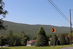
57:View of a wooded ridge in East Cameron Township
566:
8:
463:"City and Town Population Totals: 2020-2022"
573:
559:
551:
393:of any race were 1.31% of the population.
292:
81:Map of Northumberland County, Pennsylvania
31:
424:
269:, United States. The population at the
241:
229:
195:
161:
132:
119:
85:
61:
49:
29:Township in Pennsylvania, United States
490:
480:
312:
212:
187:
179:
166:
153:
150:12.01 sq mi (31.11 km)
145:
142:12.16 sq mi (31.51 km)
137:
124:
107:
95:
73:
7:
584:Northumberland County, Pennsylvania
158:0.15 sq mi (0.39 km)
36:East Cameron Township, Pennsylvania
18:West Cameron Township, Pennsylvania
581:Municipalities and communities of
509:"Census of Population and Housing"
302:
14:
173:
172:
75:
63:
51:
1:
435:. United States Census Bureau
22:Cameron County, Pennsylvania
535:United States Census Bureau
433:"2016 U.S. Gazetteer Files"
283:United States Census Bureau
192:60.77/sq mi (23.46/km)
181: • Estimate
1095:
15:
1079:Townships in Pennsylvania
1007:
635:
595:
361:
348:
333:
318:
311:
306:
301:
298:
74:
62:
50:
41:
16:Not to be confused with
405:there were 96.3 males.
642:
1050:40.75833°N 76.51639°W
919:Tharptown (Uniontown)
641:
531:"U.S. Census website"
362:U.S. Decennial Census
294:Historical population
263:Northumberland County
255:East Cameron Township
215: • Summer (
1020:United States portal
189: • Density
129:Board of Supervisors
1055:40.75833; -76.51639
1046: /
1013:Pennsylvania portal
461:Bureau, US Census.
295:
831:West Chillisquaque
741:East Chillisquaque
643:
493:has generic name (
469:. US Census Bureau
293:
168: • Total
155: • Water
139: • Total
1029:
1028:
879:Fairview-Ferndale
410:per capita income
366:
365:
281:According to the
252:
251:
147: • Land
126: • Type
1086:
1061:
1060:
1058:
1057:
1056:
1051:
1047:
1044:
1043:
1042:
1039:
1021:
1014:
640:
607:
600:
590:
585:
575:
568:
561:
552:
546:
545:
543:
541:
527:
521:
520:
518:
516:
505:
499:
498:
492:
488:
486:
478:
476:
474:
458:
445:
444:
442:
440:
429:
314:
309:
304:
296:
220:
176:
175:
79:
67:
55:
32:
1094:
1093:
1089:
1088:
1087:
1085:
1084:
1083:
1064:
1063:
1054:
1052:
1048:
1045:
1040:
1037:
1035:
1033:
1032:
1030:
1025:
1019:
1012:
1003:
935:
928:
840:
712:
644:
638:
633:
610:
605:
598:
591:
588:
583:
579:
549:
539:
537:
529:
528:
524:
514:
512:
507:
506:
502:
489:
479:
472:
470:
460:
459:
448:
438:
436:
431:
430:
426:
422:
398:married couples
379:Native American
307:
291:
279:
214:
82:
70:
58:
46:
37:
30:
25:
12:
11:
5:
1092:
1090:
1082:
1081:
1076:
1066:
1065:
1027:
1026:
1024:
1023:
1016:
1008:
1005:
1004:
1002:
1001:
996:
991:
986:
981:
976:
971:
966:
961:
956:
951:
946:
940:
938:
934:Unincorporated
930:
929:
927:
926:
921:
916:
911:
906:
901:
896:
891:
886:
881:
876:
871:
866:
861:
856:
850:
848:
842:
841:
839:
838:
833:
828:
823:
818:
813:
808:
803:
798:
793:
788:
783:
778:
773:
768:
763:
761:Little Mahanoy
758:
753:
748:
743:
738:
733:
728:
722:
720:
714:
713:
711:
710:
705:
700:
695:
690:
688:Northumberland
685:
680:
675:
670:
668:Marion Heights
665:
660:
654:
652:
646:
645:
636:
634:
632:
631:
626:
620:
618:
612:
611:
596:
593:
592:
580:
578:
577:
570:
563:
555:
548:
547:
522:
500:
446:
423:
421:
418:
364:
363:
359:
358:
355:
353:
350:
346:
345:
342:
340:
337:
331:
330:
327:
325:
322:
316:
315:
310:
305:
300:
290:
287:
278:
275:
250:
249:
246:
240:
239:
234:
228:
227:
221:
211:
210:
200:
194:
193:
190:
186:
185:
182:
178:
177:
169:
165:
164:
160:
159:
156:
152:
151:
148:
144:
143:
140:
136:
135:
131:
130:
127:
123:
122:
118:
117:
115:Northumberland
112:
106:
105:
100:
94:
93:
90:
84:
83:
80:
72:
71:
68:
60:
59:
56:
48:
47:
42:
39:
38:
35:
28:
13:
10:
9:
6:
4:
3:
2:
1091:
1080:
1077:
1075:
1072:
1071:
1069:
1062:
1059:
1022:
1017:
1015:
1010:
1009:
1006:
1000:
997:
995:
992:
990:
987:
985:
982:
980:
977:
975:
972:
970:
967:
965:
962:
960:
959:Fishers Ferry
957:
955:
952:
950:
947:
945:
942:
941:
939:
937:
931:
925:
922:
920:
917:
915:
912:
910:
907:
905:
902:
900:
897:
895:
892:
890:
887:
885:
882:
880:
877:
875:
872:
870:
867:
865:
862:
860:
857:
855:
852:
851:
849:
847:
843:
837:
834:
832:
829:
827:
824:
822:
819:
817:
816:Upper Mahanoy
814:
812:
811:Upper Augusta
809:
807:
804:
802:
799:
797:
794:
792:
789:
787:
784:
782:
779:
777:
774:
772:
771:Lower Mahanoy
769:
767:
766:Lower Augusta
764:
762:
759:
757:
754:
752:
749:
747:
744:
742:
739:
737:
734:
732:
729:
727:
724:
723:
721:
719:
715:
709:
706:
704:
701:
699:
696:
694:
691:
689:
686:
684:
681:
679:
676:
674:
671:
669:
666:
664:
661:
659:
656:
655:
653:
651:
647:
630:
627:
625:
622:
621:
619:
617:
613:
609:
608:
601:
594:
589:United States
586:
576:
571:
569:
564:
562:
557:
556:
553:
536:
532:
526:
523:
510:
504:
501:
496:
484:
468:
464:
457:
455:
453:
451:
447:
434:
428:
425:
419:
417:
415:
411:
406:
402:
399:
394:
392:
388:
384:
380:
376:
371:
360:
356:
354:
351:
347:
343:
341:
338:
336:
332:
328:
326:
323:
321:
317:
297:
288:
286:
284:
276:
274:
272:
268:
264:
260:
256:
247:
245:
238:
235:
233:
225:
222:
218:
208:
207:Eastern (EST)
204:
201:
199:
191:
183:
170:
157:
149:
141:
128:
116:
113:
111:
104:
101:
99:
92:United States
91:
89:
78:
66:
54:
45:
40:
33:
27:
23:
19:
1031:
884:Kapp Heights
826:West Cameron
776:Mount Carmel
736:East Cameron
735:
683:Mount Carmel
673:McEwensville
603:
538:. Retrieved
525:
513:. Retrieved
511:. Census.gov
503:
491:|last1=
471:. Retrieved
466:
437:. Retrieved
427:
414:poverty line
407:
403:
395:
367:
289:Demographics
280:
267:Pennsylvania
254:
253:
248:42-097-20928
103:Pennsylvania
26:
1053: /
989:Potts Grove
944:Bear Valley
936:communities
894:Marshallton
791:Rockefeller
703:Turbotville
599:County seat
540:January 31,
473:January 31,
349:2022 (est.)
271:2020 Census
1068:Categories
1041:76°30′59″W
1038:40°45′30″N
889:Locust Gap
821:Washington
708:Watsontown
698:Snydertown
467:Census.gov
439:August 14,
420:References
381:and 0.15%
368:As of the
163:Population
121:Government
964:Leck Kill
924:Trevorton
899:Montandon
718:Townships
693:Riverside
277:Geography
244:FIPS code
232:Area code
198:Time zone
954:Dornsife
949:Coal Run
874:Elysburg
869:Edgewood
859:Dalmatia
801:Shamokin
731:Delaware
663:Kulpmont
650:Boroughs
624:Shamokin
483:cite web
387:Hispanic
377:, 0.29%
259:township
44:Township
984:Natalie
979:Merrian
974:Mandata
909:Ranshaw
904:Paxinos
746:Jackson
658:Herndon
629:Sunbury
606:Sunbury
515:June 4,
88:Country
994:Rebuck
914:Strong
864:Dewart
806:Turbot
786:Ralpho
751:Jordan
678:Milton
616:Cities
391:Latino
370:census
344:−16.7%
299:Census
110:County
999:Urban
969:Malta
854:Atlas
836:Zerbe
781:Point
756:Lewis
383:Asian
375:White
357:−1.3%
257:is a
226:(EDT)
224:UTC-4
203:UTC-5
98:State
846:CDPs
796:Rush
726:Coal
542:2008
517:2016
495:help
475:2024
441:2017
335:2020
320:2010
308:Note
303:Pop.
171:623
134:Area
389:or
352:615
339:623
324:748
261:in
237:570
217:DST
184:615
20:or
1070::
602::
587:,
533:.
487::
485:}}
481:{{
465:.
449:^
385:.
313:%±
265:,
574:e
567:t
560:v
544:.
519:.
497:)
477:.
443:.
329:—
219:)
209:)
205:(
24:.
Text is available under the Creative Commons Attribution-ShareAlike License. Additional terms may apply.