29:
434:
745:
680:
41:
541:
361:. It flows north through a U-shaped glacial canyon, dropping over Carson Falls, then continues to the Silver King Valley, where it meets Silver King Creek and turns northwest, flowing to Centerville Flat where it is joined by Silver Creek and turns north. Between here and
420:(USBR) proposed their intention in 1962 to build a $ 23 million dam to both provide irrigation water for a Carson canal, and generate 800 kW of power. The waters from the dam would have extended nine miles into California. Neither the canal nor dam was never built.
729:
801:
782:
490:
333:. The north-flowing river is 61 miles (98 km) long and drains a mostly rural, mountainous watershed of 392 square miles (1,020 km).
382:
195:
722:
481:
417:
811:
511:
405:
to form the Carson River. Below this confluence the Carson River continues 131 miles (211 km) to its eventual terminus in the
684:
358:
114:
816:
775:
628:
486:
715:
649:
373:, the Alpine State Highway. At Markleeville it receives a major tributary, Markleeville Creek, before flowing north into
449:
821:
768:
806:
370:
354:
350:
96:
28:
454:
410:
366:
362:
476:
398:
374:
177:
386:
330:
390:
346:
271:
84:
752:
699:
594:
566:
515:
394:
795:
439:
402:
378:
318:
165:
744:
406:
342:
160:
429:
322:
100:
210:
197:
129:
116:
40:
679:
595:"USGS Gage #10309000 on the East Fork Carson River near Gardnerville, NV"
567:"USGS Gage #10309000 on the East Fork Carson River near Gardnerville, NV"
326:
181:
542:"USGS Gage #10309100 on the East Fork Carson River at Minden, NV"
659:. State of Nevada Division of Water Resources. December 1991
622:
756:
703:
698:This article related to a river in California is a
297:
287:
277:
264:
256:
244:
236:
226:
187:
171:
159:
145:
106:
90:
80:
71:
63:
55:
50:
21:
514:. United States Geological Survey. Archived from
751:This article related to a river in Nevada is a
377:. In Nevada the river enters the agricultural
776:
723:
8:
783:
769:
730:
716:
365:the river canyon is followed by parts of
353:. The headwaters of the river are in the
33:Rafting the East Fork of the Carson River
657:California Department of Water Resources
536:
534:
532:
491:United States Department of the Interior
401:on the western edge of the valley, near
465:
303:20,300 cu ft/s (570 m/s)
471:
469:
18:
283:376 cu ft/s (10.6 m/s)
7:
741:
739:
695:
693:
293:11 cu ft/s (0.31 m/s)
802:Rivers of Alpine County, California
604:. U.S. Geological Survey. 1939–2013
576:. U.S. Geological Survey. 1939–2013
548:. U.S. Geological Survey. 1974–1998
482:Geographic Names Information System
418:United States Bureau of Reclamation
248:392 sq mi (1,020 km)
755:. You can help Knowledge (XXG) by
702:. You can help Knowledge (XXG) by
14:
602:National Water Information System
574:National Water Information System
546:National Water Information System
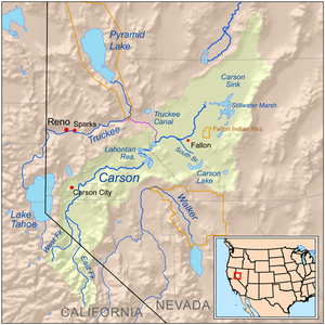
45:Map of the Carson River watershed
743:
678:
624:USGS Topo Maps for United States
432:
359:Humboldt-Toiyabe National Forest
317:is the largest tributary of the
39:
27:
629:United States Geological Survey
487:United States Geological Survey
512:"USGS National Atlas Streamer"
189: • coordinates
108: • coordinates
16:River in Nevada, United States
1:
151:10,312 ft (3,143 m)
72:Physical characteristics
450:List of rivers of California
232:4,675 ft (1,425 m)
228: • elevation
147: • elevation
266: • location
173: • location
92: • location
838:
738:
692:
299: • maximum
289: • minimum
279: • average
812:Rivers of the Great Basin
383:Washoe Indian Reservation
355:Carson-Iceberg Wilderness
351:Alpine County, California
307:
252:
155:
76:
38:
26:
477:"East Fork Carson River"
455:List of rivers of Nevada
411:Churchill County, Nevada
363:Markleeville, California
341:The river originates at
381:and passes through the
240:61 mi (98 km)
817:California river stubs
685:East Fork Carson River
627:(Map). Cartography by
399:West Fork Carson River
375:Douglas County, Nevada
315:East Fork Carson River
211:38.99083°N 119.82472°W
130:38.36139°N 119.62667°W
22:East Fork Carson River
687:at Wikimedia Commons
331:western United States
650:"Carson River Atlas"
397:. It joins with the
216:38.99083; -119.82472
135:38.36139; -119.62667
207: /
126: /
822:Nevada river stubs
321:, flowing through
67:California, Nevada
764:
763:
711:
710:
683:Media related to
311:
310:
829:
807:Rivers of Nevada
785:
778:
771:
747:
740:
732:
725:
718:
694:
682:
668:
667:
665:
664:
654:
646:
640:
639:
637:
636:
619:
613:
612:
610:
609:
599:
591:
585:
584:
582:
581:
571:
563:
557:
556:
554:
553:
538:
527:
526:
524:
523:
508:
502:
501:
499:
498:
473:
442:
437:
436:
435:
300:
290:
280:
272:Gardnerville, NV
267:
222:
221:
219:
218:
217:
212:
208:
205:
204:
203:
200:
148:
141:
140:
138:
137:
136:
131:
127:
124:
123:
122:
119:
109:
93:
43:
31:
19:
837:
836:
832:
831:
830:
828:
827:
826:
792:
791:
790:
789:
737:
736:
690:
676:
671:
662:
660:
652:
648:
647:
643:
634:
632:
621:
620:
616:
607:
605:
597:
593:
592:
588:
579:
577:
569:
565:
564:
560:
551:
549:
540:
539:
530:
521:
519:
510:
509:
505:
496:
494:
475:
474:
467:
463:
446:
445:
438:
433:
431:
426:
339:
298:
288:
278:
265:
229:
215:
213:
209:
206:
201:
198:
196:
194:
193:
190:
174:
146:
134:
132:
128:
125:
120:
117:
115:
113:
112:
107:
91:
46:
34:
17:
12:
11:
5:
835:
833:
825:
824:
819:
814:
809:
804:
794:
793:
788:
787:
780:
773:
765:
762:
761:
748:
735:
734:
727:
720:
712:
709:
708:
675:
674:External links
672:
670:
669:
641:
614:
586:
558:
528:
503:
464:
462:
459:
458:
457:
452:
444:
443:
428:
427:
425:
422:
338:
335:
309:
308:
305:
304:
301:
295:
294:
291:
285:
284:
281:
275:
274:
268:
262:
261:
258:
254:
253:
250:
249:
246:
242:
241:
238:
234:
233:
230:
227:
224:
223:
191:
188:
185:
184:
178:Douglas County
175:
172:
169:
168:
163:
157:
156:
153:
152:
149:
143:
142:
110:
104:
103:
94:
88:
87:
82:
78:
77:
74:
73:
69:
68:
65:
61:
60:
57:
53:
52:
48:
47:
44:
36:
35:
32:
24:
23:
15:
13:
10:
9:
6:
4:
3:
2:
834:
823:
820:
818:
815:
813:
810:
808:
805:
803:
800:
799:
797:
786:
781:
779:
774:
772:
767:
766:
760:
758:
754:
749:
746:
742:
733:
728:
726:
721:
719:
714:
713:
707:
705:
701:
696:
691:
688:
686:
681:
673:
658:
651:
645:
642:
631:. ACME Mapper
630:
626:
625:
618:
615:
603:
596:
590:
587:
575:
568:
562:
559:
547:
543:
537:
535:
533:
529:
518:on 2014-05-28
517:
513:
507:
504:
492:
488:
484:
483:
478:
472:
470:
466:
460:
456:
453:
451:
448:
447:
441:
440:Rivers portal
430:
423:
421:
419:
414:
412:
408:
404:
400:
396:
392:
388:
387:Dresslerville
384:
380:
379:Carson Valley
376:
372:
368:
364:
360:
356:
352:
348:
347:Sierra Nevada
344:
336:
334:
332:
328:
324:
320:
316:
306:
302:
296:
292:
286:
282:
276:
273:
269:
263:
259:
255:
251:
247:
243:
239:
235:
231:
225:
220:
192:
186:
183:
179:
176:
170:
167:
164:
162:
158:
154:
150:
144:
139:
111:
105:
102:
98:
97:Alpine County
95:
89:
86:
85:Sierra Nevada
83:
79:
75:
70:
66:
62:
59:United States
58:
54:
49:
42:
37:
30:
25:
20:
757:expanding it
750:
704:expanding it
697:
689:
677:
661:. Retrieved
656:
644:
633:. Retrieved
623:
617:
606:. Retrieved
601:
589:
578:. Retrieved
573:
561:
550:. Retrieved
545:
520:. Retrieved
516:the original
506:
495:. Retrieved
493:. 1981-01-19
480:
415:
391:Gardnerville
340:
319:Carson River
314:
312:
166:Carson River
407:Carson Sink
343:Sonora Peak
337:Description
214: /
202:119°49′29″W
133: /
121:119°37′36″W
796:Categories
663:2016-12-08
635:2016-12-08
608:2016-12-08
580:2016-12-08
552:2016-12-08
522:2016-12-08
497:2016-12-08
461:References
323:California
245:Basin size
199:38°59′27″N
118:38°21′41″N
101:California
345:, in the
257:Discharge
424:See also
51:Location
385:, past
357:of the
329:in the
56:Country
395:Minden
327:Nevada
260:
237:Length
182:Nevada
81:Source
653:(PDF)
598:(PDF)
570:(PDF)
403:Genoa
371:SR 89
270:near
161:Mouth
64:State
753:stub
700:stub
416:The
393:and
369:and
367:SR 4
325:and
313:The
409:in
349:in
798::
655:.
600:.
572:.
544:.
531:^
489:,
485:.
479:.
468:^
413:.
389:,
180:,
99:,
784:e
777:t
770:v
759:.
731:e
724:t
717:v
706:.
666:.
638:.
611:.
583:.
555:.
525:.
500:.
Text is available under the Creative Commons Attribution-ShareAlike License. Additional terms may apply.