271:
97:
212:
228:
1995:
497:
244:
122:
104:
176:
158:
194:
140:
61:
2002:
78:
2543:
2555:
2093:
2567:
2123:
2085:
2068:
1746:
1694:
1973:
1642:
1720:
1668:
1401:
in
Cranbrook. There are also hospitals in Creston (Creston Valley Hospital), Fernie (Elk Valley Hospital), Invermere (Invermere & District Hospital), and Golden (Golden & District Hospital). Primary health centers are present in Sparwood and Elkford.
1616:
96:
1796:
2192:
1846:
1871:
1771:
2264:
1896:
1563:
2366:
284:
2597:
1921:
2376:
2216:
2185:
2033:
1821:
270:
2221:
2592:
2304:
623:, whose valleys form the bottomlands of the Rocky Mountain Trench, also included in the regional district are the northernmost parts of the basins of the
2284:
2279:
2274:
2269:
2254:
2226:
2484:
2178:
2152:
2570:
2449:
1564:"Population and dwelling counts, for Canada, provinces and territories, and census divisions, 2016 and 2011 censuses – 100% data (British Columbia)"
2444:
2299:
2246:
2055:
2479:
2454:
2107:
2464:
2414:
2409:
2077:
1365:
218:
2389:
2294:
2512:
2474:
2384:
518:
2419:
2259:
2026:
604:
458:
437:
2527:
2459:
2429:
2289:
679:. With a land area of 27,514.1 km (10,623.3 sq mi), it had a population density of 2.4/km (6.2/sq mi) in 2021.
2522:
1459:
2439:
2404:
2103:
1398:
1339:
250:
635:(the Moyie and Yahk are tributaries of the Kootenay, entering it in the United States, and the Flathead is a tributary of the
2424:
565:. Despite its name, the regional district does not include all of the region known as the East Kootenay, which includes the
77:
2507:
2489:
2019:
608:
60:
2517:
2469:
2322:
2236:
2156:
1423:
825:
1443:
1439:
1427:
1326:
1287:
1274:
558:
546:
542:
337:
128:
110:
2099:
1496:
Statistic includes total responses of "Chinese", "Korean", and "Japanese" under visible minority section on census.
1447:
1419:
652:
562:
2546:
2399:
2394:
2326:
1435:
1431:
17:
1487:
Statistic includes total responses of "Filipino" and "Southeast Asian" under visible minority section on census.
2494:
2231:
2138:
1300:
1083:
1040:
550:
146:
2148:
2134:
1411:
65:
1478:
Statistic includes all persons that did not make up part of a visible minority or an indigenous identity.
2011:
911:
588:
554:
1505:
Statistic includes total responses of "West Asian" and "Arab" under visible minority section on census.
954:
656:
447:
1589:
2554:
782:
636:
473:
2005:
545:, the largest community in the region. Other important population centres include the cities of
2351:
1593:
1567:
660:
592:
514:
46:
2361:
2202:
997:
603:
region, the southern half of which is in the regional district (its northern half is in the
596:
522:
327:
2341:
600:
2001:
1994:
541:
is 27,542.69 km (10,634.29 sq mi). The regional district offices are in
496:
2500:
2356:
1415:
868:
624:
620:
616:
612:
566:
1949:
2586:
2558:
570:
1747:"Electronic Area Profiles Profile of Census Divisions and Subdivisions, 1996 Census"
2170:
1539:
691:
683:
1378:
628:
234:
2331:
718:
632:
534:
1518:" and "Multiple visible minorities" under visible minority section on census.
299:
286:
582:
423:
183:
2336:
1313:
165:
2346:
2142:
2111:
1352:
640:
201:
530:
526:
675:
total private dwellings, a change of 9% from its 2016 population of
469:
454:
433:
1251:
Note: Totals greater than 100% due to multiple origin responses.
538:
2174:
2015:
607:). Another distinct area within the regional district is the
1667:
Government of Canada, Statistics Canada (November 27, 2015).
1590:"Population and dwelling counts: Canada and census divisions"
663:, the Regional District of East Kootenay had a population of
1641:
Government of Canada, Statistics Canada (October 27, 2021).
1615:
Government of Canada, Statistics Canada (October 26, 2022).
1693:
Government of Canada, Statistics Canada (August 20, 2019).
1988:
686:
groups in the East
Kootenay Regional District (1996−2021)
485:
1514:
Statistic includes total responses of "Visible minority,
1745:
Government of Canada, Statistics Canada (June 4, 2019).
1719:
Government of Canada, Statistics Canada (July 2, 2019).
611:
in the southern
Rockies, which is the entrance to the
2042:
Places adjacent to
Regional District of East Kootenay
615:
and an important coal-mining region. Other than the
2375:
2313:
2245:
2209:
480:
465:
444:
429:
422:
414:
406:
401:
393:
388:
380:
372:
364:
356:
348:
343:
333:
323:
315:
37:
1558:
1556:
1414:people who live in the East Kootenay are from the
587:The regional district's dominant landform is the
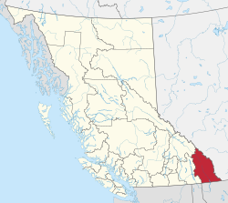
18:East Kootenay Regional District, British Columbia
1515:
2186:
2027:
397:27,541.84 km (10,633.96 sq mi)
32:Regional district in British Columbia, Canada
27:Regional district in British Columbia, Canada
8:
1617:"Census Profile, 2021 Census of Population"
2193:
2179:
2171:
2034:
2020:
2012:
1993:
1975:Census Profile, 2016 Census, East Kootenay
1944:
1942:
1397:The largest hospital in the region is the
681:
495:
211:
34:
2153:Municipal District of Pincher Creek No. 9
1259:
1531:
1471:
599:on the east and west, and includes the
479:
421:
400:
387:
342:
332:
314:
279:
89:
71:
57:
52:
2598:Regional districts of British Columbia
2108:Municipal District of Ranchland No. 66
2078:Regional District of Central Kootenay
464:
443:
428:
413:
405:
392:
379:
371:
363:
355:
347:
322:
267:
243:
7:
2049:
2566:
1950:"Our History – Lower Kootenay Band"
1847:"Invermere & District Hospital"
507:Regional District of East Kootenay
227:
2593:Regional District of East Kootenay
2089:Regional District of East Kootenay
2056:Columbia–Shuswap Regional District
775:
770:
765:
760:
755:
750:
745:
740:
735:
730:
725:
719:
605:Columbia-Shuswap Regional District
54:Regional District of East Kootenay
25:
1418:. There are currently four bands
175:
121:
103:
2565:
2553:
2542:
2541:
2121:
2091:
2083:
2066:
2000:
1872:"Golden & District Hospital"
269:
242:
226:
210:
192:
174:
157:
156:
138:
120:
102:
95:
76:
59:
2104:Kananaskis Improvement District
1399:East Kootenay Regional Hospital
193:
2280:Mountain resort municipalities
2149:Municipality of Crowsnest Pass
1897:"Sparwood Primary Health Care"
334:Administrative office location
139:
1:
2122:
2067:
1643:"Census Profile, 2016 Census"
1344:mountain resort municipality
2571:WikiProject:British Columbia
2092:
2084:
2008:travel guide from Wikivoyage
1385:
1372:
1359:
1346:
1333:
1320:
1307:
1294:
1281:
381: • Electoral areas
275:Location in British Columbia
2270:Indian government districts
1444:Tobacco Plains First Nation
1428:Lower Kootenay First Nation
2614:
2157:Improvement District No. 4
2100:Improvement District No. 9
1420:Columbia Lake First Nation
591:, which is flanked by the
580:
2547:Category:British Columbia
2536:
2047:
1721:"2001 Community Profiles"
1695:"2006 Community Profiles"
712:
709:
706:
703:
700:
697:
690:
657:2021 Census of Population
466:Electoral area C (no DST)
280:
268:
90:
72:
58:
53:
44:
2265:District municipalities
2237:Counties (court system)
1922:"Elkford Health Centre"
1436:St. Mary's First Nation
459:Mountain Daylight (MDT)
373: • Vice chair
1357:district municipality
1331:district municipality
1318:district municipality
569:and the east shore of
66:Kootenay National Park
2367:Census agglomerations
2285:Resort municipalities
2275:Island municipalities
1926:www.interiorhealth.ca
1901:www.interiorhealth.ca
1876:www.interiorhealth.ca
1851:www.interiorhealth.ca
1826:www.interiorhealth.ca
1801:www.interiorhealth.ca
1776:www.interiorhealth.ca
589:Rocky Mountain Trench
555:district municipality
446: • Summer (
418:2.4/km (6/sq mi)
2485:Okanagan–Similkameen
1540:"Board of Directors"
430:Most of the district
415: • Density
1751:www12.statcan.gc.ca
1725:www12.statcan.gc.ca
1699:www12.statcan.gc.ca
1673:www12.statcan.gc.ca
1647:www12.statcan.gc.ca
1621:www12.statcan.gc.ca
687:
376:Susan Clovechok (F)
296: /
2445:Fraser–Fort George
2377:Regional districts
2217:Regional districts
1822:"Information Page"
1797:"Information Page"
1772:"Information Page"
1596:. February 9, 2022
1570:. February 8, 2017
1366:Radium Hot Springs
682:
407: • Total
365: • Chair
360:Board of directors
300:49.9167°N 115.75°W
219:Radium Hot Springs
2580:
2579:
2513:Squamish–Lillooet
2455:Kootenay Boundary
2385:Alberni–Clayoquot
2352:Greater Vancouver
2168:
2167:
2163:
2162:
1954:lowerkootenay.com
1594:Statistics Canada
1568:Statistics Canada
1390:
1389:
1248:
1247:
1208:Total population
661:Statistics Canada
593:Purcell Mountains
519:Canadian province
515:regional district
503:
502:
394: • Land
357: • Body
352:Regional district
349: • Type
263:Major communities
47:Regional district
16:(Redirected from
2605:
2569:
2568:
2557:
2545:
2544:
2480:Northern Rockies
2465:Mount Waddington
2420:Columbia–Shuswap
2415:Central Okanagan
2410:Central Kootenay
2362:Greater Victoria
2222:School districts
2203:British Columbia
2201:Subdivisions of
2195:
2188:
2181:
2172:
2125:
2124:
2095:
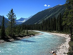
2094:
2087:
2086:
2070:
2069:
2050:
2036:
2029:
2022:
2013:
2004:
1997:
1992:
1991:
1989:Official website
1965:
1964:
1962:
1960:
1946:
1937:
1936:
1934:
1932:
1918:
1912:
1911:
1909:
1907:
1893:
1887:
1886:
1884:
1882:
1868:
1862:
1861:
1859:
1857:
1843:
1837:
1836:
1834:
1832:
1818:
1812:
1811:
1809:
1807:
1793:
1787:
1786:
1784:
1782:
1768:
1762:
1761:
1759:
1757:
1742:
1736:
1735:
1733:
1731:
1716:
1710:
1709:
1707:
1705:
1690:
1684:
1683:
1681:
1679:
1664:
1658:
1657:
1655:
1653:
1638:
1632:
1631:
1629:
1627:
1612:
1606:
1605:
1603:
1601:
1586:
1580:
1579:
1577:
1575:
1560:
1551:
1550:
1548:
1546:
1536:
1519:
1517:
1512:
1506:
1503:
1497:
1494:
1488:
1485:
1479:
1476:
1266:Government Type
1260:
1167:Total responses
777:
772:
767:
762:
757:
752:
747:
742:
737:
732:
727:
721:
688:
678:
674:
670:
666:
537:was 60,439. Its
523:British Columbia
499:
494:
491:
489:
487:
451:
384:A, B, C, E, F, G
328:British Columbia
311:
310:
308:
307:
306:
305:49.9167; -115.75
301:
297:
294:
293:
292:
289:
273:
246:
245:
230:
229:
214:
213:
196:
195:
178:
177:
160:
159:
142:
141:
124:
123:
106:
105:
99:
80:
63:
35:
21:
2613:
2612:
2608:
2607:
2606:
2604:
2603:
2602:
2583:
2582:
2581:
2576:
2532:
2528:Thompson–Nicola
2460:Metro Vancouver
2450:Kitimat–Stikine
2430:Cowichan Valley
2390:Bulkley–Nechako
2371:
2342:Greater Kelowna
2315:
2314:Metro areas and
2309:
2305:Indian reserves
2241:
2205:
2199:
2169:
2164:
2096:
2043:
2040:
1987:
1986:
1983:
1978:
1969:
1968:
1958:
1956:
1948:
1947:
1940:
1930:
1928:
1920:
1919:
1915:
1905:
1903:
1895:
1894:
1890:
1880:
1878:
1870:
1869:
1865:
1855:
1853:
1845:
1844:
1840:
1830:
1828:
1820:
1819:
1815:
1805:
1803:
1795:
1794:
1790:
1780:
1778:
1770:
1769:
1765:
1755:
1753:
1744:
1743:
1739:
1729:
1727:
1718:
1717:
1713:
1703:
1701:
1692:
1691:
1687:
1677:
1675:
1666:
1665:
1661:
1651:
1649:
1640:
1639:
1635:
1625:
1623:
1614:
1613:
1609:
1599:
1597:
1588:
1587:
1583:
1573:
1571:
1562:
1561:
1554:
1544:
1542:
1538:
1537:
1533:
1528:
1523:
1522:
1513:
1509:
1504:
1500:
1495:
1491:
1486:
1482:
1477:
1473:
1468:
1456:
1408:
1395:
1258:
869:Southeast Asian
694:
676:
672:
668:
664:
653:census division
649:
621:Kootenay Rivers
601:Columbia Valley
597:Rocky Mountains
585:
579:
484:
445:
304:
302:
298:
295:
290:
287:
285:
283:
282:
276:
264:
261:
260:
259:
258:
257:
256:
255:
247:
239:
238:
237:
231:
223:
222:
221:
215:
207:
206:
205:
197:
189:
188:
187:
179:
171:
170:
169:
161:
153:
152:
151:
143:
135:
134:
133:
125:
117:
116:
115:
107:
86:
85:
84:
83:
68:
49:
40:
33:
28:
23:
22:
15:
12:
11:
5:
2611:
2609:
2601:
2600:
2595:
2585:
2584:
2578:
2577:
2575:
2574:
2562:
2550:
2537:
2534:
2533:
2531:
2530:
2525:
2523:Sunshine Coast
2520:
2515:
2510:
2505:
2501:Stikine Region
2497:
2492:
2487:
2482:
2477:
2475:North Okanagan
2472:
2467:
2462:
2457:
2452:
2447:
2442:
2437:
2432:
2427:
2422:
2417:
2412:
2407:
2402:
2397:
2392:
2387:
2381:
2379:
2373:
2372:
2370:
2369:
2364:
2359:
2357:Greater Vernon
2354:
2349:
2344:
2339:
2334:
2329:
2319:
2317:
2316:agglomerations
2311:
2310:
2308:
2307:
2302:
2297:
2292:
2287:
2282:
2277:
2272:
2267:
2262:
2257:
2255:Municipalities
2251:
2249:
2243:
2242:
2240:
2239:
2234:
2232:Health regions
2229:
2227:Land districts
2224:
2219:
2213:
2211:
2207:
2206:
2200:
2198:
2197:
2190:
2183:
2175:
2166:
2165:
2161:
2160:
2146:
2132:
2129:
2128:
2126:
2119:
2116:
2115:
2097:
2082:
2080:
2074:
2073:
2071:
2064:
2061:
2060:
2058:
2053:
2048:
2045:
2044:
2041:
2039:
2038:
2031:
2024:
2016:
2010:
2009:
2006:East Kootenays
1998:
1982:
1981:External links
1979:
1977:
1976:
1970:
1967:
1966:
1938:
1913:
1888:
1863:
1838:
1813:
1788:
1763:
1737:
1711:
1685:
1659:
1633:
1607:
1581:
1552:
1530:
1529:
1527:
1524:
1521:
1520:
1507:
1498:
1489:
1480:
1470:
1469:
1467:
1464:
1463:
1462:
1455:
1452:
1416:Ktunaxa Nation
1407:
1404:
1394:
1391:
1388:
1387:
1384:
1381:
1375:
1374:
1371:
1368:
1362:
1361:
1358:
1355:
1349:
1348:
1345:
1342:
1336:
1335:
1332:
1329:
1323:
1322:
1319:
1316:
1310:
1309:
1306:
1303:
1297:
1296:
1293:
1290:
1284:
1283:
1280:
1277:
1271:
1270:
1267:
1264:
1257:
1256:Municipalities
1254:
1253:
1252:
1246:
1245:
1242:
1239:
1236:
1233:
1230:
1227:
1224:
1221:
1218:
1215:
1212:
1209:
1205:
1204:
1201:
1198:
1195:
1192:
1189:
1186:
1183:
1180:
1177:
1174:
1171:
1168:
1164:
1163:
1160:
1157:
1154:
1151:
1148:
1145:
1142:
1139:
1136:
1133:
1130:
1127:
1123:
1122:
1119:
1116:
1113:
1110:
1107:
1104:
1101:
1098:
1095:
1092:
1089:
1086:
1084:Middle Eastern
1080:
1079:
1076:
1073:
1070:
1067:
1064:
1061:
1058:
1055:
1052:
1049:
1046:
1043:
1041:Latin American
1037:
1036:
1033:
1030:
1027:
1024:
1021:
1018:
1015:
1012:
1009:
1006:
1003:
1000:
994:
993:
990:
987:
984:
981:
978:
975:
972:
969:
966:
963:
960:
957:
951:
950:
947:
944:
941:
938:
935:
932:
929:
926:
923:
920:
917:
914:
908:
907:
904:
901:
898:
895:
892:
889:
886:
883:
880:
877:
874:
871:
865:
864:
861:
858:
855:
852:
849:
846:
843:
840:
837:
834:
831:
828:
822:
821:
818:
815:
812:
809:
806:
803:
800:
797:
794:
791:
788:
785:
779:
778:
773:
768:
763:
758:
753:
748:
743:
738:
733:
728:
723:
715:
714:
711:
708:
705:
702:
699:
696:
648:
645:
613:Crowsnest Pass
581:Main article:
578:
575:
567:Creston Valley
529:. In the 2016
501:
500:
482:
478:
477:
474:Mountain (MST)
467:
463:
462:
452:
442:
441:
438:Mountain (MST)
431:
427:
426:
420:
419:
416:
412:
411:
408:
404:
403:
399:
398:
395:
391:
390:
386:
385:
382:
378:
377:
374:
370:
369:
366:
362:
361:
358:
354:
353:
350:
346:
345:
341:
340:
335:
331:
330:
325:
321:
320:
317:
313:
312:
278:
277:
274:
266:
265:
262:
249:
248:
241:
240:
233:
232:
225:
224:
217:
216:
209:
208:
199:
198:
191:
190:
181:
180:
173:
172:
163:
162:
155:
154:
145:
144:
137:
136:
127:
126:
119:
118:
109:
108:
101:
100:
94:
93:
92:
91:
88:
87:
81:
75:
74:
73:
70:
69:
64:
56:
55:
51:
50:
45:
42:
41:
38:
31:
26:
24:
14:
13:
10:
9:
6:
4:
3:
2:
2610:
2599:
2596:
2594:
2591:
2590:
2588:
2573:
2572:
2563:
2561:
2560:
2559:Portal:Canada
2556:
2551:
2549:
2548:
2539:
2538:
2535:
2529:
2526:
2524:
2521:
2519:
2516:
2514:
2511:
2509:
2506:
2504:
2502:
2498:
2496:
2493:
2491:
2488:
2486:
2483:
2481:
2478:
2476:
2473:
2471:
2468:
2466:
2463:
2461:
2458:
2456:
2453:
2451:
2448:
2446:
2443:
2441:
2440:Fraser Valley
2438:
2436:
2435:East Kootenay
2433:
2431:
2428:
2426:
2423:
2421:
2418:
2416:
2413:
2411:
2408:
2406:
2405:Central Coast
2403:
2401:
2398:
2396:
2393:
2391:
2388:
2386:
2383:
2382:
2380:
2378:
2374:
2368:
2365:
2363:
2360:
2358:
2355:
2353:
2350:
2348:
2345:
2343:
2340:
2338:
2335:
2333:
2330:
2328:
2324:
2321:
2320:
2318:
2312:
2306:
2303:
2301:
2298:
2296:
2293:
2291:
2288:
2286:
2283:
2281:
2278:
2276:
2273:
2271:
2268:
2266:
2263:
2261:
2258:
2256:
2253:
2252:
2250:
2248:
2244:
2238:
2235:
2233:
2230:
2228:
2225:
2223:
2220:
2218:
2215:
2214:
2212:
2208:
2204:
2196:
2191:
2189:
2184:
2182:
2177:
2176:
2173:
2158:
2154:
2150:
2147:
2144:
2140:
2136:
2133:
2131:
2130:
2127:
2120:
2118:
2117:
2113:
2109:
2105:
2101:
2098:
2090:
2081:
2079:
2076:
2075:
2072:
2065:
2063:
2062:
2059:
2057:
2054:
2052:
2051:
2046:
2037:
2032:
2030:
2025:
2023:
2018:
2017:
2014:
2007:
2003:
1999:
1996:
1990:
1985:
1984:
1980:
1974:
1972:
1971:
1955:
1951:
1945:
1943:
1939:
1927:
1923:
1917:
1914:
1902:
1898:
1892:
1889:
1877:
1873:
1867:
1864:
1852:
1848:
1842:
1839:
1827:
1823:
1817:
1814:
1802:
1798:
1792:
1789:
1777:
1773:
1767:
1764:
1752:
1748:
1741:
1738:
1726:
1722:
1715:
1712:
1700:
1696:
1689:
1686:
1674:
1670:
1669:"NHS Profile"
1663:
1660:
1648:
1644:
1637:
1634:
1622:
1618:
1611:
1608:
1595:
1591:
1585:
1582:
1569:
1565:
1559:
1557:
1553:
1541:
1535:
1532:
1525:
1511:
1508:
1502:
1499:
1493:
1490:
1484:
1481:
1475:
1472:
1465:
1461:
1460:Findlay Creek
1458:
1457:
1453:
1451:
1449:
1445:
1441:
1437:
1433:
1429:
1425:
1421:
1417:
1413:
1412:First Nations
1406:First Nations
1405:
1403:
1400:
1392:
1382:
1380:
1377:
1376:
1369:
1367:
1364:
1363:
1356:
1354:
1351:
1350:
1343:
1341:
1340:Jumbo Glacier
1338:
1337:
1330:
1328:
1325:
1324:
1317:
1315:
1312:
1311:
1304:
1302:
1299:
1298:
1291:
1289:
1286:
1285:
1278:
1276:
1273:
1272:
1268:
1265:
1263:Municipality
1262:
1261:
1255:
1250:
1249:
1243:
1240:
1237:
1234:
1231:
1228:
1225:
1222:
1219:
1216:
1213:
1210:
1207:
1206:
1202:
1199:
1196:
1193:
1190:
1187:
1184:
1181:
1178:
1175:
1172:
1169:
1166:
1165:
1161:
1158:
1155:
1152:
1149:
1146:
1143:
1140:
1137:
1134:
1131:
1128:
1125:
1124:
1120:
1117:
1114:
1111:
1108:
1105:
1102:
1099:
1096:
1093:
1090:
1087:
1085:
1082:
1081:
1077:
1074:
1071:
1068:
1065:
1062:
1059:
1056:
1053:
1050:
1047:
1044:
1042:
1039:
1038:
1034:
1031:
1028:
1025:
1022:
1019:
1016:
1013:
1010:
1007:
1004:
1001:
999:
996:
995:
991:
988:
985:
982:
979:
976:
973:
970:
967:
964:
961:
958:
956:
953:
952:
948:
945:
942:
939:
936:
933:
930:
927:
924:
921:
918:
915:
913:
910:
909:
905:
902:
899:
896:
893:
890:
887:
884:
881:
878:
875:
872:
870:
867:
866:
862:
859:
856:
853:
850:
847:
844:
841:
838:
835:
832:
829:
827:
824:
823:
819:
816:
813:
810:
807:
804:
801:
798:
795:
792:
789:
786:
784:
781:
780:
774:
769:
764:
759:
754:
749:
744:
739:
734:
729:
724:
722:
717:
716:
693:
689:
685:
680:
662:
659:conducted by
658:
654:
646:
644:
642:
638:
634:
630:
626:
622:
618:
614:
610:
606:
602:
598:
594:
590:
584:
576:
574:
572:
571:Kootenay Lake
568:
564:
560:
556:
552:
548:
544:
540:
536:
532:
528:
524:
520:
516:
512:
508:
498:
493:
483:
475:
471:
468:
460:
456:
453:
449:
439:
435:
432:
425:
417:
409:
396:
383:
375:
367:
359:
351:
339:
336:
329:
326:
318:
309:
281:Coordinates:
272:
254:
253:
252:Jumbo Glacier
236:
220:
204:
203:
186:
185:
168:
167:
150:
149:
132:
131:
114:
113:
98:
79:
67:
62:
48:
43:
39:East Kootenay
36:
30:
19:
2564:
2552:
2540:
2499:
2434:
2425:Comox Valley
2210:Subdivisions
2088:
1957:. Retrieved
1953:
1929:. Retrieved
1925:
1916:
1904:. Retrieved
1900:
1891:
1879:. Retrieved
1875:
1866:
1854:. Retrieved
1850:
1841:
1829:. Retrieved
1825:
1816:
1804:. Retrieved
1800:
1791:
1779:. Retrieved
1775:
1766:
1756:February 21,
1754:. Retrieved
1750:
1740:
1730:February 21,
1728:. Retrieved
1724:
1714:
1704:February 21,
1702:. Retrieved
1698:
1688:
1678:February 21,
1676:. Retrieved
1672:
1662:
1652:February 21,
1650:. Retrieved
1646:
1636:
1626:February 21,
1624:. Retrieved
1620:
1610:
1598:. Retrieved
1584:
1572:. Retrieved
1543:. Retrieved
1534:
1510:
1501:
1492:
1483:
1474:
1409:
1396:
650:
647:Demographics
586:
510:
506:
504:
251:
200:
182:
164:
147:
129:
111:
29:
2508:North Coast
2490:Peace River
2300:Ghost towns
2247:Communities
1393:Health care
1379:Canal Flats
1269:Population
912:South Asian
633:Yahk Rivers
368:Rob Gay (C)
303: /
291:115°45′00″W
235:Canal Flats
2587:Categories
2518:Strathcona
2332:Chilliwack
2323:Abbotsford
2141:Counties,
1959:January 4,
1931:January 4,
1906:January 4,
1881:January 4,
1856:January 4,
1831:January 4,
1806:January 4,
1781:January 4,
1526:References
1424:Windermere
955:East Asian
826:Indigenous
667:living in
637:Clark Fork
609:Elk Valley
553:, and the
535:population
424:Time zones
402:Population
344:Government
288:49°55′00″N
2159:(Alberta)
1440:Cranbrook
1327:Invermere
1288:Kimberley
1275:Cranbrook
692:Panethnic
684:Panethnic
583:Kootenays
577:Geography
559:Invermere
547:Kimberley
543:Cranbrook
338:Cranbrook
184:Invermere
130:Kimberley
112:Cranbrook
2503:(non-RD)
2337:Kamloops
2295:Villages
2139:Flathead
1600:April 3,
1454:See also
1448:Grasmere
1383:village
1370:village
1314:Sparwood
783:European
625:Flathead
617:Columbia
563:Sparwood
324:Province
166:Sparwood
2470:Nanaimo
2400:Cariboo
2395:Capital
2347:Nanaimo
2327:Mission
2143:Montana
2135:Lincoln
2112:Alberta
1574:July 9,
1545:July 9,
1432:Creston
1353:Elkford
1282:20,047
1241:56,366
1235:56,291
1229:55,485
1223:56,685
1217:60,439
1211:65,896
1203:99.31%
1200:55,975
1197:99.29%
1194:55,890
1191:98.92%
1188:54,885
1185:98.22%
1182:55,675
1179:98.01%
1176:59,235
1173:97.76%
1170:64,420
998:African
817:52,560
814:92.57%
811:51,740
808:92.05%
805:50,520
799:50,385
796:88.36%
793:52,340
790:86.54%
787:55,750
671:of its
655:in the
641:Montana
517:in the
513:) is a
481:Website
316:Country
202:Elkford
2495:qathet
2260:Cities
2137:&
1516:n.i.e.
1442:, and
1360:2,499
1334:3.391
1321:3,784
1308:5,249
1301:Fernie
1295:8,115
1162:0.22%
1156:0.07%
1150:0.05%
1144:0.26%
1138:0.19%
1132:0.16%
1126:Other
1121:0.02%
1109:0.13%
1091:0.04%
1078:0.09%
1072:0.13%
1066:0.03%
1060:0.16%
1054:0.24%
1048:0.29%
1035:0.21%
1029:0.28%
1023:0.09%
1011:0.51%
1005:0.61%
986:0.75%
980:0.88%
974:0.98%
968:1.13%
962:1.21%
949:0.63%
943:0.54%
937:0.27%
931:0.45%
919:1.28%
906:0.28%
900:0.49%
894:0.24%
888:0.51%
882:0.93%
863:3.77%
860:2,110
857:5.17%
854:2,890
851:6.24%
848:3,425
845:6.79%
842:3,780
839:7.94%
836:4,705
833:8.53%
830:5,495
820:93.9%
802:90.5%
695:group
677:60,439
673:35,931
669:28,264
665:65,896
551:Fernie
533:, the
531:census
527:Canada
410:65,896
319:Canada
148:Fernie
2290:Towns
1466:Notes
1446:near
1438:near
1430:near
1422:near
1305:city
1292:city
1279:city
1244:100%
1238:100%
1232:100%
1226:100%
1220:100%
1214:100%
1097:0.1%
1017:0.3%
992:0.9%
925:0.6%
876:1.3%
713:1996
710:2001
707:2006
704:2011
701:2016
698:2021
651:As a
629:Moyie
488:.rdek
470:UTC-7
455:UTC-6
434:UTC-7
2145:(US)
1961:2021
1933:2021
1908:2021
1883:2021
1858:2021
1833:2021
1808:2021
1783:2021
1758:2023
1732:2023
1706:2023
1680:2023
1654:2023
1628:2023
1602:2022
1576:2019
1547:2019
1410:The
1386:668
1373:776
1159:125
1141:145
1135:110
1129:100
1051:145
1045:190
1032:115
1026:155
1014:165
1008:305
1002:395
989:505
983:420
977:485
971:545
965:670
959:780
946:350
940:300
934:150
928:250
922:355
916:825
903:155
897:275
891:130
885:285
879:550
873:840
771:Pop.
761:Pop.
751:Pop.
741:Pop.
731:Pop.
720:Pop.
631:and
619:and
595:and
561:and
549:and
539:area
511:RDEK
505:The
389:Area
82:Logo
1153:40
1147:30
1118:10
1115:0%
1106:70
1103:0%
1094:60
1088:25
1075:50
1069:70
1063:15
1057:90
1020:50
643:).
639:in
557:of
521:of
492:.ca
490:.bc
486:www
448:DST
2589::
2155:/
2151:/
2106:/
2102:/
1952:.
1941:^
1924:.
1899:.
1874:.
1849:.
1824:.
1799:.
1774:.
1749:.
1723:.
1697:.
1671:.
1645:.
1619:.
1592:.
1566:.
1555:^
1450:.
1434:,
1426:,
1347:0
1112:0
1100:0
627:,
573:.
525:,
2325:–
2194:e
2187:t
2180:v
2114:)
2110:(
2035:e
2028:t
2021:v
1963:.
1935:.
1910:.
1885:.
1860:.
1835:.
1810:.
1785:.
1760:.
1734:.
1708:.
1682:.
1656:.
1630:.
1604:.
1578:.
1549:.
776:%
766:%
756:%
746:%
736:%
726:%
509:(
476:)
472:(
461:)
457:(
450:)
440:)
436:(
20:)
Text is available under the Creative Commons Attribution-ShareAlike License. Additional terms may apply.