45:
991:
687:
66:
96:
1226:
103:
73:
389:
The present unincorporated community of
Eastaboga was listed as the incorporated town of McFall on the 1900 census and had 820 residents. Of that, a majority, 482, lived on the Talladega County side, and 338 lived on the Calhoun County side. It was disincorporated after just 3 years in 1901 and the
44:
50:
295:. It was previously called McFall, named for a settling family in the 1850s, and incorporated in 1898, only to be disincorporated in 1901. The original community of Eastaboga was to the south and became known as
1290:
1300:
908:
1271:
390:
post office closed under that name in 1906. At some point on, it was renamed
Eastaboga (while the nearby community to the south of the same name became "Old Eastaboga").
591:
1295:
1305:
490:
1130:
901:
128:
95:
1264:
759:
584:
1115:
65:
481:
260:
894:
1257:
1079:
1094:
577:
486:
886:
569:
536:
314:
Eastaboga is located in the northern part of
Talladega County on the border with Calhoun County. The city is located along
754:
182:
1025:
415:
918:
368:
280:
319:
315:
248:
160:
476:
1233:
1046:
779:
721:
601:
284:
187:
1196:
1173:
1140:
866:
434:
296:
253:
1054:
959:
843:
784:
744:
653:
403:
1203:
1135:
873:
815:
739:
706:
221:
561:
503:
1155:
1069:
820:
805:
769:
729:
323:
276:
49:
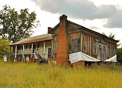
The
Jemison House Complex is located in Eastaboga, Alabama. It was built c. 1840 and placed on the
35:
1089:
1020:
980:
975:
940:
810:
795:
670:
1150:
1105:
1084:
711:
664:
642:
623:
331:
303:
211:
1145:
1125:
1120:
1110:
1030:
1015:
1010:
964:
647:
522:
410:
1059:
969:
838:
676:
658:
330:
is 100 mi (160 km) east. The largest city of over 20,000 people in the area is
1241:
1036:
800:
734:
322:, which runs west to east south of the community, with access from exit 173. Via I-20,
1284:
749:
516:
540:
933:
616:
1225:
1165:
830:
406:
399:
288:
170:
143:
130:
421:
202:
1187:‡This populated place also has portions in an adjacent county or counties
857:‡This populated place also has portions in an adjacent county or counties
236:
1237:
327:
292:
175:
302:
Eastaboga (historically
Estaboga) means "where the people reside" in
990:
454:
686:
228:
207:
562:
http://alabamamaps.ua.edu/historicalplaces/text/TalladegaText.pdf
504:
http://alabamamaps.ua.edu/historicalplaces/text/TalladegaText.pdf
1002:
951:
698:
634:
890:
573:
989:
685:
334:, which is east 13 mi (21 km) via I-20 or US 78.
1245:
518:
The Origin of
Certain Place Names in the United States
1291:
Unincorporated communities in
Calhoun County, Alabama
1182:
1164:
1068:
1045:
1001:
950:
852:
829:
768:
720:
697:
633:
259:
247:
235:
218:
201:
193:
181:
169:
159:
26:
21:Unincorporated community in Alabama, United States
16:Unincorporated community in Alabama, United States
299:after McFall's name was changed to Eastaboga.
1265:
902:
585:
8:
1301:Alabama placenames of Native American origin
994:Map of Alabama highlighting Talladega County
1272:
1258:
909:
895:
887:
690:Map of Alabama highlighting Calhoun County
592:
578:
570:
341:
102:
72:
23:
491:United States Department of the Interior
446:
318:about 2 mi (3.2 km) north of
258:
234:
200:
192:
158:
123:
57:
41:
361:
1296:Unincorporated communities in Alabama
326:is 51 mi (82 km) west, and
246:
217:
180:
168:
7:
1222:
1220:
51:National Register of Historic Places
482:Geographic Names Information System
917:Municipalities and communities of
600:Municipalities and communities of
351:
14:
1224:
101:
94:
71:
64:
43:
1306:Central Alabama geography stubs
487:United States Geological Survey
306:, a Native American language.
1:
521:. Govt. Print. Off. pp.
115:Show map of the United States
1244:. You can help Knowledge by
1240:state location article is a
539:. Census.gov. Archived from
1322:
1219:
1192:
987:
931:
920:Talladega County, Alabama
862:
683:
614:
382:
367:
360:
355:
350:
347:
124:
58:
42:
33:
277:unincorporated community
197:587 ft (179 m)
36:Unincorporated community
603:Calhoun County, Alabama
537:"U.S. Decennial Census"
515:Gannett, Henry (1905).
457:. zipdatamaps.com. 2022
995:
691:
435:Old Eastaboga, Alabama
993:
689:
404:Major League Baseball
383:U.S. Decennial Census
343:Historical population
220: • Summer (
144:33.60583°N 86.02139°W
1205:United States portal
875:United States portal
455:"Eastaboga ZIP Code"
344:
149:33.60583; -86.02139
140: /
85:Show map of Alabama
996:
755:West End-Cobb Town
692:
342:
109:Eastaboga, Alabama
79:Eastaboga, Alabama
53:on October 1, 1990
28:Eastaboga, Alabama
1253:
1252:
1214:
1213:
1026:Talladega Springs
884:
883:
543:on April 26, 2015
387:
386:
279:on the border of
270:
269:
1313:
1274:
1267:
1260:
1228:
1221:
1206:
1199:
992:
943:
936:
926:
921:
911:
904:
897:
888:
876:
869:
688:
626:
619:
609:
604:
594:
587:
580:
571:
564:
559:
553:
552:
550:
548:
533:
527:
526:
512:
506:
501:
495:
494:
473:
467:
466:
464:
462:
451:
411:New York Yankees
363:
358:
353:
345:
287:counties in the
225:
155:
154:
152:
151:
150:
145:
141:
138:
137:
136:
133:
116:
105:
104:
98:
86:
75:
74:
68:
47:
24:
1321:
1320:
1316:
1315:
1314:
1312:
1311:
1310:
1281:
1280:
1279:
1278:
1217:
1215:
1210:
1204:
1197:
1188:
1178:
1160:
1071:
1064:
1041:
997:
985:
946:
941:
934:
927:
924:
919:
915:
885:
880:
874:
867:
858:
848:
825:
771:
764:
716:
693:
681:
629:
624:
617:
610:
607:
602:
598:
568:
567:
560:
556:
546:
544:
535:
534:
530:
514:
513:
509:
502:
498:
475:
474:
470:
460:
458:
453:
452:
448:
443:
431:
424:, NASCAR driver
418:, NASCAR driver
396:
356:
340:
312:
243:
219:
148:
146:
142:
139:
134:
131:
129:
127:
126:
120:
119:
118:
117:
114:
113:
112:
111:
110:
106:
89:
88:
87:
84:
83:
82:
81:
80:
76:
54:
38:
29:
22:
17:
12:
11:
5:
1319:
1317:
1309:
1308:
1303:
1298:
1293:
1283:
1282:
1277:
1276:
1269:
1262:
1254:
1251:
1250:
1234:Calhoun County
1229:
1212:
1211:
1209:
1208:
1201:
1198:Alabama portal
1193:
1190:
1189:
1186:
1184:
1180:
1179:
1177:
1176:
1170:
1168:
1162:
1161:
1159:
1158:
1153:
1148:
1143:
1138:
1133:
1128:
1123:
1118:
1113:
1108:
1103:
1097:
1092:
1087:
1082:
1076:
1074:
1070:Unincorporated
1066:
1065:
1063:
1062:
1057:
1051:
1049:
1043:
1042:
1040:
1039:
1034:
1028:
1023:
1018:
1013:
1007:
1005:
999:
998:
988:
986:
984:
983:
978:
973:
967:
962:
956:
954:
948:
947:
932:
929:
928:
916:
914:
913:
906:
899:
891:
882:
881:
879:
878:
871:
868:Alabama portal
863:
860:
859:
856:
854:
850:
849:
847:
846:
841:
835:
833:
827:
826:
824:
823:
818:
813:
808:
803:
798:
793:
787:
782:
780:Chosea Springs
776:
774:
770:Unincorporated
766:
765:
763:
762:
757:
752:
747:
742:
737:
732:
726:
724:
718:
717:
715:
714:
709:
703:
701:
695:
694:
684:
682:
680:
679:
674:
668:
662:
656:
651:
645:
639:
637:
631:
630:
615:
612:
611:
599:
597:
596:
589:
582:
574:
566:
565:
554:
528:
507:
496:
468:
445:
444:
442:
439:
438:
437:
430:
427:
426:
425:
419:
413:
395:
394:Notable people
392:
385:
384:
380:
379:
376:
374:
371:
365:
364:
359:
354:
349:
339:
336:
311:
308:
268:
267:
264:
257:
256:
251:
245:
244:
241:
239:
233:
232:
226:
216:
215:
205:
199:
198:
195:
191:
190:
185:
179:
178:
173:
167:
166:
163:
157:
156:
122:
121:
108:
107:
100:
99:
93:
92:
91:
90:
78:
77:
70:
69:
63:
62:
61:
60:
59:
56:
55:
48:
40:
39:
34:
31:
30:
27:
20:
15:
13:
10:
9:
6:
4:
3:
2:
1318:
1307:
1304:
1302:
1299:
1297:
1294:
1292:
1289:
1288:
1286:
1275:
1270:
1268:
1263:
1261:
1256:
1255:
1249:
1247:
1243:
1239:
1235:
1230:
1227:
1223:
1218:
1207:
1202:
1200:
1195:
1194:
1191:
1185:
1181:
1175:
1174:Gantts Quarry
1172:
1171:
1169:
1167:
1163:
1157:
1154:
1152:
1149:
1147:
1144:
1142:
1141:Old Eastaboga
1139:
1137:
1134:
1132:
1129:
1127:
1124:
1122:
1119:
1117:
1114:
1112:
1109:
1107:
1104:
1101:
1098:
1096:
1093:
1091:
1088:
1086:
1083:
1081:
1078:
1077:
1075:
1073:
1067:
1061:
1058:
1056:
1053:
1052:
1050:
1048:
1044:
1038:
1035:
1032:
1029:
1027:
1024:
1022:
1019:
1017:
1014:
1012:
1009:
1008:
1006:
1004:
1000:
982:
979:
977:
974:
971:
968:
966:
963:
961:
958:
957:
955:
953:
949:
945:
944:
937:
930:
925:United States
922:
912:
907:
905:
900:
898:
893:
892:
889:
877:
872:
870:
865:
864:
861:
855:
851:
845:
842:
840:
837:
836:
834:
832:
828:
822:
819:
817:
814:
812:
809:
807:
804:
802:
799:
797:
794:
791:
788:
786:
783:
781:
778:
777:
775:
773:
767:
761:
758:
756:
753:
751:
748:
746:
743:
741:
738:
736:
733:
731:
728:
727:
725:
723:
719:
713:
710:
708:
705:
704:
702:
700:
696:
678:
675:
672:
669:
666:
663:
660:
657:
655:
652:
649:
646:
644:
641:
640:
638:
636:
632:
628:
627:
620:
613:
608:United States
605:
595:
590:
588:
583:
581:
576:
575:
572:
563:
558:
555:
542:
538:
532:
529:
524:
520:
519:
511:
508:
505:
500:
497:
492:
488:
484:
483:
478:
472:
469:
456:
450:
447:
440:
436:
433:
432:
428:
423:
420:
417:
414:
412:
408:
405:
401:
398:
397:
393:
391:
381:
377:
375:
372:
370:
366:
346:
337:
335:
333:
329:
325:
321:
320:Interstate 20
317:
316:U.S. Route 78
309:
307:
305:
300:
298:
297:Old Eastaboga
294:
290:
286:
282:
278:
274:
265:
262:
255:
254:256 & 938
252:
250:
240:
238:
230:
227:
223:
213:
212:Central (CST)
209:
206:
204:
196:
189:
186:
184:
177:
174:
172:
165:United States
164:
162:
153:
125:Coordinates:
97:
67:
52:
46:
37:
32:
25:
19:
1246:expanding it
1231:
1216:
1131:Liberty Hill
1099:
1055:Fayetteville
960:Childersburg
939:
844:Tooktocaugee
789:
785:DeArmanville
760:White Plains
745:Nances Creek
654:Jacksonville
622:
557:
545:. Retrieved
541:the original
531:
517:
510:
499:
480:
471:
461:November 11,
459:. Retrieved
449:
388:
338:Demographics
313:
301:
272:
271:
249:Area code(s)
18:
1136:Mardisville
1072:communities
935:County seat
816:Possum Trot
772:communities
740:Choccolocco
707:Hobson City
618:County seat
477:"Eastaboga"
147: /
1285:Categories
1166:Ghost town
1156:Winterboro
831:Ghost town
821:Wellington
806:Merrellton
730:Alexandria
441:References
416:Johnny Ray
407:outfielder
400:Howie Camp
324:Birmingham
289:U.S. state
263:feature ID
135:86°01′17″W
132:33°36′21″N
1183:Footnotes
1116:Kahatchie
1100:Eastaboga
1090:Chinnabee
1021:Oak Grove
981:Talladega
976:Sylacauga
942:Talladega
853:Footnotes
811:Peaceburg
796:Iron City
790:Eastaboga
671:Southside
422:Kevin Ray
402:, former
310:Geography
281:Talladega
273:Eastaboga
203:Time zone
194:Elevation
1151:Sycamore
1106:Fishtrap
1085:Bemiston
712:Ohatchee
665:Piedmont
643:Anniston
625:Anniston
429:See also
409:for the
332:Anniston
304:Muscogee
237:ZIP code
1238:Alabama
1146:Renfroe
1126:Laniers
1121:Kentuck
1111:Hopeful
1031:Vincent
1016:Munford
1011:Bon Air
965:Lincoln
648:Glencoe
547:June 6,
328:Atlanta
293:Alabama
285:Calhoun
188:Calhoun
176:Alabama
161:Country
1080:Alpine
1060:Mignon
970:Oxford
952:Cities
839:Minden
677:Weaver
659:Oxford
635:Cities
348:Census
275:is an
266:157941
183:County
1232:This
1095:Curry
1037:Waldo
1003:Towns
801:Macon
735:Bynum
699:Towns
242:36260
231:(CDT)
229:UTC-5
208:UTC-6
171:State
1242:stub
1047:CDPs
750:Saks
722:CDPs
549:2013
463:2022
369:1900
357:Note
352:Pop.
283:and
261:GNIS
523:121
373:820
291:of
222:DST
1287::
1236:,
938::
923:,
621::
606:,
489:,
485:.
479:.
362:%±
1273:e
1266:t
1259:v
1248:.
1102:‡
1033:‡
972:‡
910:e
903:t
896:v
792:‡
673:‡
667:‡
661:‡
650:‡
593:e
586:t
579:v
551:.
525:.
493:.
465:.
378:—
224:)
214:)
210:(
Text is available under the Creative Commons Attribution-ShareAlike License. Additional terms may apply.