438:
423:
411:
79:
363:
387:
375:
51:
86:
58:
34:
399:
539:
284:, and is orientated to the northwest. The tumulus has an overall length of 170 meters, and is the largest of a group of eight tumuli in this vicinity. It is estimated to have been constructed in the middle of the Kofun period, or the early 4th century. The tumulus was constructed in three tiers, and had both
437:
422:
410:
304:
and three burial facilities have been found in the center of the posterior circular portion, of which one contained a boat-shaped sarcophagus with elaborate carvings.
78:
312:
and iron swords and spearheads. The sarcophagus was designated a Kyoto
Prefecture Tangible Cultural Property in 2019. Currently, the site, together with the
135:
362:
280:, which is shaped like a keyhole, having one square end and one circular end, when viewed from above. It is located in the Noda River basin in the
457:
386:
374:
568:
578:
50:
516:
398:
481:
297:
543:
313:
301:
573:
583:
33:
328:
256:
213:
512:
320:
477:
281:
562:
309:
248:
244:
123:
109:
237:
191:
324:
305:
550:
150:
137:
538:
286:
292:
252:
240:
113:
316:, is open to the public as the Yosano Municipal Kofun Park.
243:, located in the Yosano neighborhood of the town of
202:
197:
187:
179:
174:
166:
129:
119:
105:
273:
229:
509:(国指定史跡事典) National Historic Site Encyclopedia
8:
350:100 meter diameter x 16 meters high, 3-tiers
319:The tumulus is about 15 minutes by car from
19:
32:
18:
16:Kofun period burial mound in Yosano, Japan
502:
500:
498:
480:[Ebisuyama Kofun] (in Japanese).
469:
458:List of Historic Sites of Japan (Kyoto)
358:
344:62 meters wide x 11 meters high, 3-tier
85:
57:
507:Isomura, Yukio; Sakai, Hideya (2012).
7:
551:Yosano Tourist Information home page
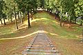
368:Summit of posterior circular portion
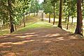
392:Anterior looking towards posterior
380:Posterior looking towards anterior
14:
290:, and cylindrical and figurative
537:
436:
421:
409:
397:
385:
373:
361:
84:
77:
56:
49:
257:National Historic Site of Japan
255:. The tumulus was designated a
214:National Historic Site of Japan
1:
341:Anterior rectangular portion
68:Show map of Kyoto Prefecture
569:History of Kyoto Prefecture
482:Agency for Cultural Affairs
298:1927 North Tango earthquake
600:
347:Posterior circular portion
296:. After damage due to the
151:35.5071556°N 135.1045139°E
274:
267:The Ebisuyama Kofun is a
230:
210:
43:
31:
24:
579:Historic Sites of Japan
156:35.5071556; 135.1045139
93:Ebisuyama Kofun (Japan)
546:at Wikimedia Commons
329:Kyoto Tango Railway
206:Yes (No facilities)
147: /
21:
300:, the tumulus was
203:Public access
542:Media related to
314:Tsukuriyama Kofun
221:
220:
96:Show map of Japan
591:
555:
541:
526:
525:
522:
504:
493:
492:
490:
488:
474:
440:
425:
413:
401:
389:
377:
365:
321:Nodagawa Station
279:
277:
276:
235:
233:
232:
162:
161:
159:
158:
157:
152:
148:
145:
144:
143:
140:
97:
88:
87:
81:
69:
60:
59:
53:
36:
22:
599:
598:
594:
593:
592:
590:
589:
588:
559:
558:
553:
544:Ebisuyama Kofun
535:
530:
529:
523:
519:
506:
505:
496:
486:
484:
476:
475:
471:
466:
454:
447:
441:
432:
426:
417:
414:
405:
402:
393:
390:
381:
378:
369:
366:
357:
282:Tango Peninsula
271:
265:
227:
225:Ebisuyama Kofun
217:
216:
155:
153:
149:
146:
141:
138:
136:
134:
133:
101:
100:
99:
98:
95:
94:
91:
90:
89:
72:
71:
70:
67:
66:
65:Ebisuyama Kofun
63:
62:
61:
39:
38:Ebisuyama Kofun
27:
20:Ebisuyama Kofun
17:
12:
11:
5:
597:
595:
587:
586:
581:
576:
571:
561:
560:
557:
556:
534:
533:External links
531:
528:
527:
517:
494:
468:
467:
465:
462:
461:
460:
453:
450:
449:
448:
442:
435:
433:
427:
420:
418:
416:iron spearhead
415:
408:
406:
403:
396:
394:
391:
384:
382:
379:
372:
370:
367:
360:
356:
353:
352:
351:
348:
345:
342:
339:
336:
310:bronze mirrors
269:zenpō-kōen-fun
264:
261:
219:
218:
212:
211:
208:
207:
204:
200:
199:
195:
194:
189:
185:
184:
181:
177:
176:
172:
171:
168:
164:
163:
131:
127:
126:
121:
117:
116:
107:
103:
102:
92:
83:
82:
76:
75:
74:
73:
64:
55:
54:
48:
47:
46:
45:
44:
41:
40:
37:
29:
28:
25:
15:
13:
10:
9:
6:
4:
3:
2:
596:
585:
582:
580:
577:
575:
574:Yosano, Kyoto
572:
570:
567:
566:
564:
554:(in Japanese)
552:
549:
548:
547:
545:
540:
532:
524:(in Japanese)
520:
514:
510:
503:
501:
499:
495:
483:
479:
473:
470:
463:
459:
456:
455:
451:
446:
439:
434:
431:
424:
419:
412:
407:
400:
395:
388:
383:
376:
371:
364:
359:
354:
349:
346:
343:
340:
337:
334:
333:
332:
330:
326:
322:
317:
315:
311:
307:
303:
299:
295:
294:
289:
288:
283:
270:
262:
260:
258:
254:
250:
249:Kansai region
246:
245:Yosano, Kyoto
242:
239:
226:
215:
209:
205:
201:
196:
193:
190:
186:
183:c.4th century
182:
178:
173:
169:
165:
160:
142:135°6′16.25″E
139:35°30′25.76″N
132:
128:
125:
124:Kansai region
122:
118:
115:
111:
110:Yosano, Kyoto
108:
104:
80:
52:
42:
35:
30:
23:
584:Zenpokoenfun
536:
508:
485:. Retrieved
472:
444:
443:Cylindrical
429:
428:Cylindrical
335:Total length
318:
291:
285:
268:
266:
241:burial mound
238:Kofun period
224:
222:
192:Kofun period
404:Sarcophagus
338:170 meters:
325:Miyazu Line
306:Grave goods
154: /
130:Coordinates
563:Categories
518:4311750404
487:August 20,
464:References
198:Site notes
308:included
302:excavated
259:in 1930.
452:See also
287:fukiishi
263:Overview
106:Location
511:. 学生社.
478:"蛭子山古墳"
355:Gallery
327:of the
323:on the
247:in the
188:Periods
180:Founded
175:History
515:
445:haniwa
430:haniwa
293:haniwa
120:Region
275:前方後円墳
253:Japan
236:is a
231:蛭子山古墳
170:Kofun
114:Japan
26:蛭子山古墳
513:ISBN
489:2020
223:The
167:Type
251:of
565::
497:^
331:.
112:,
521:.
491:.
278:)
272:(
234:)
228:(
Text is available under the Creative Commons Attribution-ShareAlike License. Additional terms may apply.