415:
31:
432:. The Reverend Humphrey Sandford bought Edgton in 1812 for £235, so this is when it became a state parish. At the edge of the village there is the Anglo-Saxon church, which in the past allowed travellers to rest at night without disturbing the residents. There is a road which runs nearby the village at Edgton Cross, which has a 19th-century milestone showing that London is 154 miles away and that Bishop's Castle is 5 miles away. There are many milestones along this road, which suggests that it was an important access route in the past.
47:
523:
is a large decrease in the population between 1891 and 1901. The population drops from 185 to 134, which is a loss of 51 people. From 1911, the population of Edgton continues to decrease until there are only 86 people in 1961. Overall, the population has decreased significantly from 1801 to 1961. This indicates that many people wanted to move away from the rural village.
831:
54:
444:. Edgton is located within the Shropshire Hills Area of Outstanding Natural Beauty. The area is made up of a large amount of woodland and arable and pasture land. The natural features of the village such as the mature trees, hedges, stone walls and historic boundaries are very important and need to be preserved.
224:
522:
This graph shows that in 1801, Edgton had a population of 188. This gradually increased each year until 1831, when the population reached its highest with 232 people. The population then begins to decrease, however, there is an increase in people from 1851 to 1881 from 191 people to 223 people. There
505:
This pie chart shows the occupational structure of Edgton in 1831. It clearly shows that over half of the population at this time worked as agricultural labourers. 24% of the population worked in retail and handicrafts. 15% of the population worked as farmers and the other 7% worked in labour. There
388:
The village of Edgton contains 3 farms and approximately 20 dwellings. It has very few services as the school (built in 1872), the shop and the village public house were all closed down. The school is currently used as a pottery. The village is fairly compact as it is centred on the 3 farms and the
392:
Edgton is home to St
Michael's church which was established in the early 13th century. It was rebuilt in 1985-6 and is now a grade II listed building. Before the church was renovated it had fallen into a state of disrepair. Reverend Jones spent £250 of his own money on the repairs and £50 was
498:
427:
Edgton was part of Clun registration district, Clun and
Bishops Castle registration district, Lydbury registration sub-district and the Purslow hundred. Edgton used to belong to the ancient monastery of
1213:
264:
762:
802:
738:
248:
559:
1208:
380:
lies a few miles to the west. It is located 4 miles west of Craven Arms and is positioned on the former stagecoach route from London to Bishop's Castle.
723:
414:
85:
1228:
393:
contributed from the
Ecclesiastical Commission. It is a small and intimate church, containing traditional carved box pews and a recently renovated
515:
210:
1223:
1269:
1218:
1029:
862:
1192:
272:
236:
241:
30:
46:
290:
1274:
1248:
253:
198:
164:
872:
735:
308:
128:
1233:
1203:
1198:
78:
1243:
1183:
300:
567:
1238:
532:
295:
674:
855:
401:
178:
1091:
1152:
1051:
1021:
1010:
154:
1188:
1173:
1111:
1076:
951:
893:
643:
110:
1000:
971:
848:
514:
1168:
898:
835:
447:
The following buildings and landmarks are regarded as monuments in the Edgton
Conservation Area:
229:
146:
118:
916:
584:
497:
361:
1178:
936:
441:
1147:
1142:
1137:
203:
931:
742:
486:
373:
1061:
961:
429:
405:
1263:
1086:
394:
377:
1116:
1096:
1046:
966:
699:
345:
94:
840:
1121:
1071:
1056:
946:
365:
357:
1106:
1101:
1066:
1005:
986:
921:
878:
353:
136:
67:
352:
and a chapelry. It lies in a rather remote and very rural area, south of the
323:
310:
1081:
188:
830:
411:
Edgton is believed to mean a "settlement on a hill with an edge or brow".
976:
926:
991:
981:
170:
995:
956:
349:
757:
755:
753:
751:
513:
496:
413:
506:
440:
On 16 December 1993, the central part of Edgton was designated a
941:
369:
844:
1016:
638:
636:
634:
632:
630:
628:
626:
624:
622:
620:
618:
616:
614:
612:
610:
608:
606:
408:; this is due to the very small population of the parish.
669:
667:
588:
457:
The pedestal tomb 6m south west of Church of St
Michael
797:
795:
793:
791:
789:
787:
785:
783:
348:
in
Shropshire, England. It is also an ecclesiastical
579:
577:
1161:
1130:
1039:
907:
886:
518:
A bar chart showing the population change in Edgton
263:
247:
235:
223:
209:
197:
187:
177:
163:
145:
127:
109:
93:
77:
23:
554:
552:
550:
548:
454:The Sundial 2m south west of Church of St Michael
469:The Cowhouse 10m south west of Church Farmhouse
856:
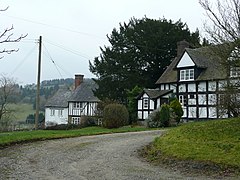
418:St Michael's Church and the Pottery in Edgton
8:
481:Lower House Farmhouse and attached cowhouse
472:The House on the Green (a 1-storey cottage)
863:
849:
841:
466:The Barn 5m south east of church Farmhouse
20:
544:
262:
218:
186:
162:
76:
27:
501:A pie chart showing occupational data
246:
234:
222:
208:
196:
176:
144:
126:
108:
7:
1030:List of civil parishes in Shropshire
803:"Historical Statistics – Population"
463:Church Farmhouse (former malt house)
763:"Historical Statistics – Industry"
14:
651:South Shropshire District Council
829:
700:"St Michael's Church of England"
52:
45:
29:
745:Edgton Parish Meeting – details
726:Map of Local Joint Committee 19
485:Almost all of these places are
376:, while the larger village of
53:
35:Half-timbered houses in Edgton
1:
1270:Civil parishes in Shropshire
1209:Parliamentary constituencies
79:OS grid reference
18:Human settlement in England
1291:
1229:Grade II* listed buildings
644:"Edgton Conservation Area"
533:Listed buildings in Edgton
489:to help to protect them.
281:
259:
219:
40:
28:
1224:Grade I listed buildings
679:British Listed Buildings
451:The Church of St Michael
344:is a small village and
1275:Villages in Shropshire
1153:Shropshire Union Canal
675:"Church of St Michael"
519:
502:
493:Occupational structure
419:
199:Postcode district
129:Ceremonial county
111:Unitary authority
838:at Wikimedia Commons
704:The Church of England
517:
500:
417:
741:4 March 2016 at the
570:on 24 December 2012.
179:Sovereign state
910:(cities in italics)
887:Unitary authorities
320: /
899:Telford and Wrekin
724:Shropshire Council
591:on 7 February 2011
520:
503:
420:
265:UK Parliament
211:Dialling code
1257:
1256:
1179:Shrewsbury floods
937:Cleobury Mortimer
908:Major settlements
873:Ceremonial county
834:Media related to
807:Vision of Britain
767:Vision of Britain
564:Vision of Britain
442:conservation area
436:Conservation Area
339:
338:
1282:
1234:Lord Lieutenants
1148:Shrewsbury Canal
1143:Montgomery Canal
1138:Llangollen Canal
881:
875:
865:
858:
851:
842:
833:
818:
817:
815:
813:
799:
778:
777:
775:
773:
759:
746:
733:
727:
721:
715:
714:
712:
710:
696:
690:
689:
687:
685:
671:
662:
661:
659:
657:
648:
640:
601:
600:
598:
596:
587:. Archived from
585:"Edgton Village"
581:
572:
571:
566:. Archived from
556:
475:Edgton Farmhouse
335:
334:
332:
331:
330:
325:
324:52.466°N 2.903°W
321:
318:
317:
316:
313:
287:
173:
89:
88:
66:Location within
56:
55:
49:
33:
21:
1290:
1289:
1285:
1284:
1283:
1281:
1280:
1279:
1260:
1259:
1258:
1253:
1157:
1126:
1035:
1024:
932:Church Stretton
917:Bishop's Castle
909:
903:
882:
877:
871:
869:
827:
822:
821:
811:
809:
801:
800:
781:
771:
769:
761:
760:
749:
743:Wayback Machine
734:
730:
722:
718:
708:
706:
698:
697:
693:
683:
681:
673:
672:
665:
655:
653:
646:
642:
641:
604:
594:
592:
583:
582:
575:
558:
557:
546:
541:
529:
512:
495:
487:Grade II listed
478:Villa Farmhouse
460:Manor Farmhouse
438:
425:
386:
374:Church Stretton
362:Bishop's Castle
328:
326:
322:
319:
314:
311:
309:
307:
306:
305:
285:
277:
169:
159:
141:
123:
105:
84:
83:
73:
72:
71:
70:
64:
63:
62:
61:
57:
36:
19:
12:
11:
5:
1288:
1286:
1278:
1277:
1272:
1262:
1261:
1255:
1254:
1252:
1251:
1246:
1244:Rail transport
1241:
1236:
1231:
1226:
1221:
1219:Country houses
1216:
1211:
1206:
1201:
1196:
1186:
1181:
1176:
1171:
1165:
1163:
1159:
1158:
1156:
1155:
1150:
1145:
1140:
1134:
1132:
1128:
1127:
1125:
1124:
1119:
1114:
1109:
1104:
1099:
1094:
1089:
1084:
1079:
1074:
1069:
1064:
1059:
1054:
1049:
1043:
1041:
1037:
1036:
1034:
1033:
1019:
1014:
1008:
1003:
998:
989:
984:
979:
974:
969:
964:
962:Market Drayton
959:
954:
949:
944:
939:
934:
929:
924:
919:
913:
911:
905:
904:
902:
901:
896:
890:
888:
884:
883:
870:
868:
867:
860:
853:
845:
826:
825:External links
823:
820:
819:
779:
747:
728:
716:
691:
663:
602:
573:
560:"Unit History"
543:
542:
540:
537:
536:
535:
528:
525:
511:
508:
494:
491:
483:
482:
479:
476:
473:
470:
467:
464:
461:
458:
455:
452:
437:
434:
430:Wenlock Priory
424:
421:
406:parish meeting
402:parish council
385:
382:
356:. The nearest
337:
336:
329:52.466; -2.903
304:
303:
298:
293:
288:
286:List of places
282:
279:
278:
276:
275:
269:
267:
261:
260:
257:
256:
251:
245:
244:
239:
233:
232:
227:
221:
220:
217:
216:
213:
207:
206:
201:
195:
194:
191:
185:
184:
183:United Kingdom
181:
175:
174:
167:
161:
160:
158:
157:
151:
149:
143:
142:
140:
139:
133:
131:
125:
124:
122:
121:
115:
113:
107:
106:
104:
103:
99:
97:
91:
90:
81:
75:
74:
65:
59:
58:
51:
50:
44:
43:
42:
41:
38:
37:
34:
26:
25:
17:
13:
10:
9:
6:
4:
3:
2:
1287:
1276:
1273:
1271:
1268:
1267:
1265:
1250:
1247:
1245:
1242:
1240:
1239:High Sheriffs
1237:
1235:
1232:
1230:
1227:
1225:
1222:
1220:
1217:
1215:
1212:
1210:
1207:
1205:
1202:
1200:
1197:
1194:
1190:
1187:
1185:
1182:
1180:
1177:
1175:
1172:
1170:
1167:
1166:
1164:
1160:
1154:
1151:
1149:
1146:
1144:
1141:
1139:
1136:
1135:
1133:
1129:
1123:
1120:
1118:
1115:
1113:
1110:
1108:
1105:
1103:
1100:
1098:
1095:
1093:
1090:
1088:
1085:
1083:
1080:
1078:
1075:
1073:
1070:
1068:
1065:
1063:
1060:
1058:
1055:
1053:
1050:
1048:
1045:
1044:
1042:
1038:
1032:
1031:
1027:
1023:
1020:
1018:
1015:
1012:
1009:
1007:
1004:
1002:
999:
997:
993:
990:
988:
985:
983:
980:
978:
975:
973:
970:
968:
965:
963:
960:
958:
955:
953:
950:
948:
945:
943:
940:
938:
935:
933:
930:
928:
925:
923:
920:
918:
915:
914:
912:
906:
900:
897:
895:
892:
891:
889:
885:
880:
874:
866:
861:
859:
854:
852:
847:
846:
843:
839:
837:
832:
824:
808:
804:
798:
796:
794:
792:
790:
788:
786:
784:
780:
768:
764:
758:
756:
754:
752:
748:
744:
740:
737:
732:
729:
725:
720:
717:
705:
701:
695:
692:
680:
676:
670:
668:
664:
652:
645:
639:
637:
635:
633:
631:
629:
627:
625:
623:
621:
619:
617:
615:
613:
611:
609:
607:
603:
590:
586:
580:
578:
574:
569:
565:
561:
555:
553:
551:
549:
545:
538:
534:
531:
530:
526:
524:
516:
509:
507:
499:
492:
490:
488:
480:
477:
474:
471:
468:
465:
462:
459:
456:
453:
450:
449:
448:
445:
443:
435:
433:
431:
422:
416:
412:
409:
407:
403:
400:Instead of a
398:
396:
395:chamber organ
390:
383:
381:
379:
378:Lydbury North
375:
371:
367:
363:
359:
355:
351:
347:
343:
333:
302:
299:
297:
294:
292:
289:
284:
283:
280:
274:
271:
270:
268:
266:
258:
255:
254:West Midlands
252:
250:
243:
240:
238:
231:
228:
226:
214:
212:
205:
202:
200:
192:
190:
182:
180:
172:
168:
166:
156:
155:West Midlands
153:
152:
150:
148:
138:
135:
134:
132:
130:
120:
117:
116:
114:
112:
101:
100:
98:
96:
92:
87:
82:
80:
69:
48:
39:
32:
22:
16:
1028:
1025:
967:Much Wenlock
828:
810:. Retrieved
806:
770:. Retrieved
766:
731:
719:
707:. Retrieved
703:
694:
682:. Retrieved
678:
654:. Retrieved
650:
593:. Retrieved
589:the original
568:the original
563:
521:
510:Demographics
504:
484:
446:
439:
426:
410:
399:
391:
387:
358:market towns
346:civil parish
341:
340:
95:Civil parish
15:
1184:Settlements
947:Craven Arms
384:The village
366:Craven Arms
327: /
230:West Mercia
193:CRAVEN ARMS
1264:Categories
1022:Whitchurch
1011:Wellington
1006:Oakengates
987:Shrewsbury
922:Bridgnorth
894:Shropshire
879:Shropshire
539:References
354:River Onny
312:52°27′58″N
301:Shropshire
242:Shropshire
137:Shropshire
119:Shropshire
68:Shropshire
1249:Windmills
1193:Civil War
1082:Rea Brook
1026:See also:
952:Ellesmere
404:it has a
315:2°54′11″W
249:Ambulance
189:Post town
1062:Ledwyche
977:Oswestry
927:Broseley
812:17 March
772:14 March
739:Archived
527:See also
389:church.
86:SO386857
1204:Schools
1199:Museums
1189:History
1174:Geology
1087:Redlake
1001:Madeley
992:Telford
982:Shifnal
972:Newport
709:1 March
684:1 March
656:1 March
595:1 March
423:History
296:England
171:England
165:Country
1162:Topics
1131:Canals
1117:Vyrnwy
1097:Severn
1047:Camlad
1040:Rivers
996:Dawley
957:Ludlow
836:Edgton
350:parish
342:Edgton
273:Ludlow
225:Police
147:Region
102:Edgton
60:Edgton
24:Edgton
1214:SSSIs
1122:Worfe
1092:Roden
1072:Perry
1057:Corve
736:CPALC
647:(PDF)
215:01588
1169:Flag
1107:Tern
1102:Teme
1067:Onny
1052:Clun
942:Clun
814:2012
774:2012
711:2012
686:2012
658:2012
597:2012
372:and
370:Clun
360:are
237:Fire
1112:Unk
1077:Rea
1017:Wem
876:of
204:SY7
1266::
805:.
782:^
765:.
750:^
702:.
677:.
666:^
649:.
605:^
576:^
562:.
547:^
397:.
368:,
364:,
291:UK
1195:)
1191:(
1013:)
994:(
864:e
857:t
850:v
816:.
776:.
713:.
688:.
660:.
599:.
Text is available under the Creative Commons Attribution-ShareAlike License. Additional terms may apply.