58:
39:
65:
388:
241:
February through March and in
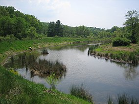
October. The stream on the WMA is a designated catch and release trout stream. A primitive camping area is in proximity to Edwards Pond and pit toilets and trash receptacles are provided. A nominal camping fee is charged by the WVDNR.
349:
1636:
1458:
419:
1193:
663:
467:
449:
531:
57:
1595:
1631:
475:
1183:
498:
991:
898:
271:
1263:
412:
97:
1363:
1283:
1208:
787:
392:
1605:
1398:
1238:
1073:
1068:
732:
559:
324:
172:
1258:
1133:
903:
595:
457:
1463:
1343:
1093:
1008:
405:
1368:
1138:
1088:
1018:
1318:
1288:
1253:
1038:
605:
440:
1273:
1078:
554:
480:
1388:
1313:
1298:
1233:
1218:
1203:
1178:
1153:
1108:
1083:
1033:
1013:
782:
757:
521:
1373:
1348:
1198:
1173:
1148:
1098:
1058:
1023:
428:
1406:
1358:
1308:
1303:
1223:
1143:
938:
1600:
1338:
1328:
1293:
1278:
1213:
1168:
1128:
1123:
1103:
1053:
1043:
1003:
1383:
1378:
1353:
1048:
882:
847:
694:
1243:
1163:
1158:
1248:
762:
752:
671:
490:
168:
84:
648:
28:
1473:
842:
380:
320:
148:
1453:
862:
633:
628:
535:
1548:
727:
722:
685:
503:
160:
1528:
837:
164:
1573:
961:
951:
742:
1626:
946:
852:
832:
807:
638:
546:
513:
1568:
1533:
1228:
966:
923:
872:
857:
817:
1538:
178:
Edwards Run WMA primarily consists of low hills with steep slopes covered in forests of various species of
1523:
1506:
1438:
1323:
976:
928:
867:
802:
792:
777:
772:
643:
569:
357:
1448:
956:
913:
827:
822:
812:
797:
747:
717:
623:
525:
1578:
291:
1553:
971:
767:
737:
653:
618:
613:
1563:
1558:
1518:
981:
712:
256:
38:
707:
1433:
1333:
1268:
908:
877:
587:
577:
221:
and a 2-acre (8,100 m) lake, Edwards Pond, provide fishing for smallmouth and largemouth
187:
702:
1063:
1028:
234:
1113:
214:
1620:
1483:
432:
226:
191:
186:
plus approximately 17 acres (69,000 m) of scattered clearings and brushy areas.
1543:
1468:
397:
1478:
328:
251:
222:
218:
43:
1443:
112:
99:
918:
387:
230:
199:
1188:
266:
261:
210:
183:
207:
203:
159:
is located on 397 acres (1.6 km) two miles (3 km) north of
238:
195:
72:
Location of
Edwards Run Wildlife Management Area in West Virginia
16:
State
Wildlife Management Area in Hampshire County, West Virginia
401:
179:
64:
321:"West Virginia DNR - District 2 Wildlife Management Areas"
381:
West
Virginia DNR District 2 Wildlife Management Areas
1596:
West
Virginia Department of Environmental Protection
1505:
1496:
1426:
1419:
1397:
990:
937:
891:
693:
684:
662:
604:
586:
568:
545:
512:
489:
466:
448:
439:
144:
136:
128:
91:
80:
21:
1637:Protected areas of Hampshire County, West Virginia
272:List of West Virginia wildlife management areas
413:
237:. Edwards Run and Pond are also stocked with
8:
1606:West Virginia Division of Natural Resources
325:West Virginia Division of Natural Resources
315:
313:
173:West Virginia Division of Natural Resources
163:on Cold Stream Road (County Route 15) near
1632:Wildlife management areas of West Virginia
1502:
1423:
690:
445:
420:
406:
398:
149:WVDNR District 2 Wildlife Management Areas
18:
283:
350:"Edwards Run Wildlife Management Area"
292:"Edwards Run Wildlife Management Area"
7:
393:Edwards Run Wildlife Management Area
157:Edwards Run Wildlife Management Area
79:
22:Edwards Run Wildlife Management Area
1407:West Virginia State Wildlife Center
213:opportunities are available in the
1601:West Virginia Division of Forestry
171:. Edwards Run WMA is owned by the
14:
578:Appalachian National Scenic Trail
386:
63:
56:
37:
31:V (protected landscape/seascape)
499:George Washington and Jefferson
169:Hampshire County, West Virginia
1194:Lantz Farm and Nature Preserve
87:, West Virginia, United States
1:
634:Laurel Fork South Wilderness
629:Laurel Fork North Wilderness
1655:
783:Droop Mountain Battlefield
758:Carnifex Ferry Battlefield
1591:
649:Roaring Plains Wilderness
547:National Wildlife Refuges
514:National Recreation Areas
476:Chesapeake and Ohio Canal
468:National Historical Parks
51:
36:
26:
639:Mountain Lake Wilderness
532:Spruce Knob–Seneca Rocks
215:wildlife management area
140:816 ft (249 m)
1184:Huttonsville State Farm
132:397 acres (161 ha)
1439:Camp Mad Anthony Wayne
1324:Stonewall Jackson Lake
929:Morgan Morgan Monument
883:Watters Smith Memorial
848:Stonewall Jackson Lake
793:Greenbrier River Trail
644:Otter Creek Wilderness
570:National Trails System
358:U.S. Geological Survey
1449:James Rumsey Monument
1264:Pruntytown State Farm
914:James Rumsey Monument
823:North Bend Rail Trail
733:Blennerhassett Island
624:Dolly Sods Wilderness
395:at Wikimedia Commons
113:39.32250°N 78.43778°W
1459:Marland Heights Park
1374:Valley Bend Wetlands
899:Booker T. Washington
763:Cass Scenic Railroad
753:Canaan Valley Resort
654:Spice Run Wilderness
619:Cranberry Wilderness
614:Big Draft Wilderness
1364:Upper Deckers Creek
1284:Shannondale Springs
1209:Little Indian Creek
257:Animal conservation
118:39.32250; -78.43778
109: /
46:in Edwards Run WMA.
1574:Upper Shavers Fork
1549:Mount Porte Crayon
1239:Nathaniel Mountain
1074:Cecil H. Underwood
1069:Castleman Run Lake
892:Former state parks
588:National Preserves
560:Ohio River Islands
1614:
1613:
1587:
1586:
1529:Cranesville Swamp
1492:
1491:
1434:Cameron City Pool
1415:
1414:
1399:Other WVDNR sites
1334:Summersville Lake
1259:Plum Orchard Lake
1134:Fairfox Pond-Rehe
909:Grave Creek Mound
863:Twin Falls Resort
680:
679:
391:Media related to
188:White-tailed deer
154:
153:
1644:
1503:
1424:
1344:Teter Creek Lake
1269:R.D. Bailey Lake
1094:Conaway Run Lake
1009:Amherst-Plymouth
728:Blackwater Falls
723:Berkeley Springs
691:
606:Wilderness Areas
491:National Forests
446:
422:
415:
408:
399:
390:
368:
367:
365:
364:
346:
340:
339:
337:
336:
327:. Archived from
317:
308:
307:
305:
303:
296:Protected Planet
288:
124:
123:
121:
120:
119:
114:
110:
107:
106:
105:
102:
67:
66:
60:
41:
19:
1654:
1653:
1647:
1646:
1645:
1643:
1642:
1641:
1627:IUCN Category V
1617:
1616:
1615:
1610:
1583:
1511:
1508:
1498:
1488:
1427:Municipal parks
1411:
1393:
1369:Upper Mud River
1139:Fort Mill Ridge
1089:Chief Cornstalk
1064:Burnsville Lake
1029:Beech Fork Lake
1019:Bear Rocks Lake
995:
993:
986:
933:
887:
843:Prickett's Fort
838:Pipestem Resort
676:
664:National Rivers
658:
600:
596:New River Gorge
582:
564:
541:
508:
485:
462:
458:New River Gorge
435:
429:Protected areas
426:
377:
372:
371:
362:
360:
354:Elevation Query
348:
347:
343:
334:
332:
319:
318:
311:
301:
299:
290:
289:
285:
280:
248:
235:channel catfish
217:. A section of
117:
115:
111:
108:
103:
100:
98:
96:
95:
76:
75:
74:
73:
70:
69:
68:
47:
32:
17:
12:
11:
5:
1652:
1651:
1648:
1640:
1639:
1634:
1629:
1619:
1618:
1612:
1611:
1609:
1608:
1603:
1598:
1592:
1589:
1588:
1585:
1584:
1582:
1581:
1576:
1571:
1569:Slaty Mountain
1566:
1561:
1556:
1551:
1546:
1541:
1536:
1531:
1526:
1521:
1515:
1513:
1500:
1494:
1493:
1490:
1489:
1487:
1486:
1481:
1476:
1471:
1466:
1461:
1456:
1451:
1446:
1441:
1436:
1430:
1428:
1421:
1417:
1416:
1413:
1412:
1410:
1409:
1403:
1401:
1395:
1394:
1392:
1391:
1386:
1381:
1376:
1371:
1366:
1361:
1356:
1351:
1346:
1341:
1336:
1331:
1326:
1321:
1319:Stonecoal Lake
1316:
1311:
1306:
1301:
1296:
1291:
1289:Short Mountain
1286:
1281:
1276:
1271:
1266:
1261:
1256:
1254:Pleasant Creek
1251:
1246:
1241:
1236:
1231:
1226:
1221:
1216:
1211:
1206:
1201:
1196:
1191:
1186:
1181:
1176:
1171:
1166:
1161:
1156:
1151:
1146:
1141:
1136:
1131:
1126:
1121:
1116:
1114:East Lynn Lake
1111:
1106:
1101:
1096:
1091:
1086:
1081:
1076:
1071:
1066:
1061:
1056:
1051:
1046:
1041:
1039:Beury Mountain
1036:
1031:
1026:
1021:
1016:
1011:
1006:
1000:
998:
988:
987:
985:
984:
979:
974:
969:
964:
959:
954:
949:
943:
941:
935:
934:
932:
931:
926:
921:
916:
911:
906:
901:
895:
893:
889:
888:
886:
885:
880:
875:
870:
865:
860:
855:
850:
845:
840:
835:
830:
825:
820:
815:
810:
805:
800:
795:
790:
785:
780:
775:
770:
765:
760:
755:
750:
745:
743:Cacapon Resort
740:
735:
730:
725:
720:
715:
710:
705:
699:
697:
688:
682:
681:
678:
677:
675:
674:
668:
666:
660:
659:
657:
656:
651:
646:
641:
636:
631:
626:
621:
616:
610:
608:
602:
601:
599:
598:
592:
590:
584:
583:
581:
580:
574:
572:
566:
565:
563:
562:
557:
551:
549:
543:
542:
540:
539:
529:
518:
516:
510:
509:
507:
506:
501:
495:
493:
487:
486:
484:
483:
478:
472:
470:
464:
463:
461:
460:
454:
452:
450:National Parks
443:
437:
436:
427:
425:
424:
417:
410:
402:
384:
383:
376:
375:External links
373:
370:
369:
341:
309:
282:
281:
279:
276:
275:
274:
269:
264:
259:
254:
247:
244:
152:
151:
146:
142:
141:
138:
134:
133:
130:
126:
125:
93:
89:
88:
82:
78:
77:
71:
62:
61:
55:
54:
53:
52:
49:
48:
42:
34:
33:
27:
24:
23:
15:
13:
10:
9:
6:
4:
3:
2:
1650:
1649:
1638:
1635:
1633:
1630:
1628:
1625:
1624:
1622:
1607:
1604:
1602:
1599:
1597:
1594:
1593:
1590:
1580:
1577:
1575:
1572:
1570:
1567:
1565:
1562:
1560:
1557:
1555:
1552:
1550:
1547:
1545:
1542:
1540:
1537:
1535:
1534:Greenland Gap
1532:
1530:
1527:
1525:
1522:
1520:
1517:
1516:
1514:
1510:
1504:
1501:
1495:
1485:
1484:Wheeling Park
1482:
1480:
1479:Staunton Park
1477:
1475:
1472:
1470:
1467:
1465:
1464:Memorial Park
1462:
1460:
1457:
1455:
1452:
1450:
1447:
1445:
1442:
1440:
1437:
1435:
1432:
1431:
1429:
1425:
1422:
1418:
1408:
1405:
1404:
1402:
1400:
1396:
1390:
1387:
1385:
1382:
1380:
1377:
1375:
1372:
1370:
1367:
1365:
1362:
1360:
1357:
1355:
1352:
1350:
1347:
1345:
1342:
1340:
1337:
1335:
1332:
1330:
1327:
1325:
1322:
1320:
1317:
1315:
1312:
1310:
1307:
1305:
1302:
1300:
1297:
1295:
1292:
1290:
1287:
1285:
1282:
1280:
1277:
1275:
1274:Ritchie Mines
1272:
1270:
1267:
1265:
1262:
1260:
1257:
1255:
1252:
1250:
1247:
1245:
1242:
1240:
1237:
1235:
1232:
1230:
1227:
1225:
1222:
1220:
1217:
1215:
1212:
1210:
1207:
1205:
1202:
1200:
1197:
1195:
1192:
1190:
1187:
1185:
1182:
1180:
1177:
1175:
1172:
1170:
1167:
1165:
1162:
1160:
1157:
1155:
1152:
1150:
1147:
1145:
1142:
1140:
1137:
1135:
1132:
1130:
1127:
1125:
1122:
1120:
1117:
1115:
1112:
1110:
1107:
1105:
1102:
1100:
1097:
1095:
1092:
1090:
1087:
1085:
1082:
1080:
1079:Center Branch
1077:
1075:
1072:
1070:
1067:
1065:
1062:
1060:
1057:
1055:
1052:
1050:
1047:
1045:
1042:
1040:
1037:
1035:
1032:
1030:
1027:
1025:
1022:
1020:
1017:
1015:
1012:
1010:
1007:
1005:
1002:
1001:
999:
997:
989:
983:
980:
978:
975:
973:
970:
968:
965:
963:
960:
958:
955:
953:
950:
948:
945:
944:
942:
940:
939:State forests
936:
930:
927:
925:
922:
920:
917:
915:
912:
910:
907:
905:
902:
900:
897:
896:
894:
890:
884:
881:
879:
876:
874:
871:
869:
866:
864:
861:
859:
856:
854:
853:Tomlinson Run
851:
849:
846:
844:
841:
839:
836:
834:
833:Pinnacle Rock
831:
829:
826:
824:
821:
819:
816:
814:
811:
809:
808:Little Beaver
806:
804:
801:
799:
796:
794:
791:
789:
788:Fairfax Stone
786:
784:
781:
779:
776:
774:
771:
769:
766:
764:
761:
759:
756:
754:
751:
749:
746:
744:
741:
739:
736:
734:
731:
729:
726:
724:
721:
719:
716:
714:
711:
709:
706:
704:
701:
700:
698:
696:
692:
689:
687:
683:
673:
672:Bluestone NSR
670:
669:
667:
665:
661:
655:
652:
650:
647:
645:
642:
640:
637:
635:
632:
630:
627:
625:
622:
620:
617:
615:
612:
611:
609:
607:
603:
597:
594:
593:
591:
589:
585:
579:
576:
575:
573:
571:
567:
561:
558:
556:
555:Canaan Valley
553:
552:
550:
548:
544:
537:
533:
530:
527:
523:
520:
519:
517:
515:
511:
505:
502:
500:
497:
496:
494:
492:
488:
482:
481:Harpers Ferry
479:
477:
474:
473:
471:
469:
465:
459:
456:
455:
453:
451:
447:
444:
442:
438:
434:
433:West Virginia
430:
423:
418:
416:
411:
409:
404:
403:
400:
396:
394:
389:
382:
379:
378:
374:
359:
355:
351:
345:
342:
331:on 2016-07-09
330:
326:
322:
316:
314:
310:
297:
293:
287:
284:
277:
273:
270:
268:
265:
263:
260:
258:
255:
253:
250:
249:
245:
243:
240:
236:
232:
228:
224:
220:
216:
212:
209:
205:
201:
197:
193:
189:
185:
181:
176:
174:
170:
166:
162:
158:
150:
147:
143:
139:
135:
131:
127:
122:
94:
90:
86:
83:
59:
50:
45:
40:
35:
30:
29:IUCN category
25:
20:
1559:Panther Knob
1544:Ice Mountain
1539:Hungry Beech
1499:governmental
1469:Oglebay Park
1454:Magic Island
1389:Woodrum Lake
1314:South Branch
1299:Sleepy Creek
1234:Morris Creek
1229:Moncove Lake
1219:Meadow River
1204:Lewis Wetzel
1179:Hughes River
1154:Green Bottom
1118:
1109:Dunkard Fork
1084:Cheat Canyon
1034:Berwind Lake
1014:Anawalt Lake
962:Coopers Rock
952:Calvin Price
924:Mont Chateau
873:Valley Falls
858:Tu-Endie-Wei
818:Moncove Lake
522:Gauley River
385:
361:. Retrieved
353:
344:
333:. Retrieved
329:the original
300:. Retrieved
295:
286:
177:
161:Capon Bridge
156:
155:
44:Edwards Pond
1524:Brush Creek
1509:Conservancy
1474:Ritter Park
1349:Thorn Creek
1199:Laurel Lake
1174:Horse Creek
1149:Frozen Camp
1119:Edwards Run
1099:Cross Creek
1059:Burches Run
1024:Becky Creek
947:Cabwaylingo
868:Tygart Lake
803:Holly River
778:Chief Logan
773:Cedar Creek
695:State parks
504:Monongahela
252:Edwards Run
219:Edwards Run
165:Cold Stream
116: /
92:Coordinates
1621:Categories
1519:Bear Rocks
1444:Fries Park
1359:Turkey Run
1309:Snake Hill
1304:Smoke Camp
1224:Mill Creek
1144:Fox Forest
994:management
967:Greenbrier
957:Camp Creek
828:North Bend
813:Lost River
798:Hawks Nest
748:Camp Creek
718:Beech Fork
363:2008-10-22
335:2008-10-22
278:References
104:78°26′16″W
101:39°19′21″N
1564:Pike Knob
1512:preserves
1339:Tate Lohr
1329:Stumptown
1294:Slatyfork
1279:Sand Hill
1214:McClintic
1169:Hillcrest
1129:Elk River
1124:Elk Creek
1104:Dents Run
1054:Bluestone
1044:Big Ditch
1004:Allegheny
977:Kumbrabow
919:Mingo Oak
904:Grandview
768:Cathedral
738:Bluestone
184:hickories
137:Elevation
85:Hampshire
1579:Yankauer
1384:Widmeyer
1379:Wallback
1354:Tug Fork
1049:Big Ugly
992:Wildlife
713:Beartown
302:30 April
246:See also
231:bluegill
200:squirrel
81:Location
1244:Panther
1189:The Jug
1164:Hilbert
1159:Handley
972:Kanawha
708:Babcock
441:Federal
267:Hunting
262:Fishing
227:sunfish
211:hunting
145:Website
1554:Murphy
1507:Nature
1249:Pedlar
982:Seneca
878:Watoga
298:. IUCN
233:, and
208:grouse
206:, and
204:rabbit
192:turkey
1420:Local
996:areas
703:Audra
686:State
239:trout
196:quail
1497:Non-
536:USFS
304:2018
223:bass
182:and
180:oaks
129:Area
526:NPS
431:of
167:in
1623::
356:.
352:.
323:.
312:^
294:.
229:,
225:,
202:,
198:,
194:,
190:,
175:.
538:)
534:(
528:)
524:(
421:e
414:t
407:v
366:.
338:.
306:.
Text is available under the Creative Commons Attribution-ShareAlike License. Additional terms may apply.