20:
35:
113:
226:
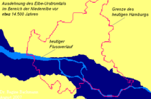
124:, about 22,000 to 18,000 years ago, and the end of the glaciation in North Germany about 14,500 years ago. At that time the glacier was melting and the waters attempted to find their way to the lowest lying points. The Elbe Urstromtal collected the meltwaters and carried them to the
67:
19:
263:
292:
34:
317:
302:
128:, which then lay up to 120 meters below its present level. The then coastline was about 600 kilometers (370 miles) further north.
322:
312:
190:
256:
297:
307:
189:
which was the old river bank. Likewise, there is a roughly 30-meter-high slope at the height of
Hamburg's western
249:
140:
136:
162:
has neither dried out nor silted up, but still carries the River Elbe, which has its source in the
Bohemian
144:
121:
101:
112:
282:
182:
163:
71:
233:
150:
Today, the course of the Elbe
Urstromtal roughly follows the course of the present day
287:
276:
225:
202:
198:
206:
186:
170:
96:
82:
over a length of around 300 kilometers (190 miles) between the German town of
125:
87:
91:
120:
The Elbe
Urstromtal probably emerged between the coldest period of the
83:
43:
169:
The old course of the meltwater river can be easily made out in the
178:
111:
33:
27:
151:
79:
131:
The Elbe
Urstromtal also collected the meltwaters of the three
177:) region. For example, there is still a roughly 50-meter-high
100:, or glacial meltwater valley, emerged at the height of the
147:
and carried them in the direction of the North Sea Basin.
26:. An 1811 painting by L.P. Strack illustrating the steep
237:
86:, Saxony-Anhalt, and the Elbe's mouth into the
257:
8:
264:
250:
78:) refers to the present-day valley of the
18:
116:Cross sections through the Elbe Valley
7:
222:
220:
154:river, because – unlike other
232:This German location article is a
14:
224:
24:View from Baur's Park to Hamburg
293:Landforms of Schleswig-Holstein
1:
236:. You can help Knowledge by
56: current Elbe river bed
50: ancient Elbe river bed
339:
219:
318:Valleys of Saxony-Anhalt
303:Landforms of Brandenburg
141:Warsaw-Berlin Urstromtal
137:Glogau-Baruth Urstromtal
323:Germany geography stubs
313:Valleys of Lower Saxony
122:Weichselian glaciation
117:
102:Weichselian glaciation
75:
58:
31:
115:
37:
22:
298:Landforms of Hamburg
145:Eberswald Urstromtal
94:, Lower Saxony. The
118:
59:
32:
308:Valleys of Saxony
245:
244:
158: – the Elbe
330:
266:
259:
252:
228:
221:
70:
55:
49:
338:
337:
333:
332:
331:
329:
328:
327:
273:
272:
271:
270:
217:
215:
164:Giant Mountains
110:
76:Elbe-Urstromtal
66:
63:Elbe Urstromtal
57:
53:
51:
47:
17:
12:
11:
5:
336:
334:
326:
325:
320:
315:
310:
305:
300:
295:
290:
285:
275:
274:
269:
268:
261:
254:
246:
243:
242:
229:
214:
211:
109:
106:
52:
46:
42:in and around
38:Extent of the
15:
13:
10:
9:
6:
4:
3:
2:
335:
324:
321:
319:
316:
314:
311:
309:
306:
304:
301:
299:
296:
294:
291:
289:
286:
284:
281:
280:
278:
267:
262:
260:
255:
253:
248:
247:
241:
239:
235:
230:
227:
223:
218:
212:
210:
208:
204:
200:
196:
192:
188:
184:
180:
176:
172:
167:
165:
161:
157:
156:Urstromtälern
153:
148:
146:
142:
138:
134:
129:
127:
123:
114:
107:
105:
103:
99:
98:
93:
89:
85:
81:
77:
73:
69:
64:
45:
41:
36:
29:
25:
21:
238:expanding it
231:
216:
194:
191:Elbe suburbs
174:
168:
159:
155:
149:
133:urstromtäler
132:
130:
119:
95:
62:
60:
39:
23:
203:Nienstedten
199:Othmarschen
181:slope from
283:Urstromtal
277:Categories
213:References
207:Blankenese
195:Elbvororte
187:Geesthacht
175:Niederelbe
171:Lower Elbe
160:Urstromtal
143:and Thorn-
97:urstromtal
40:urstromtal
183:Bergedorf
126:North Sea
88:North Sea
68:‹See Tfd›
92:Cuxhaven
108:History
84:Genthin
44:Hamburg
135:, the
72:German
54:
48:
30:slope.
16:Valley
179:geest
90:near
28:Geest
288:Elbe
234:stub
205:and
152:Elbe
80:Elbe
61:The
197:)
185:to
279::
209:.
201:,
166:.
139:,
104:.
74::
265:e
258:t
251:v
240:.
193:(
173:(
65:(
Text is available under the Creative Commons Attribution-ShareAlike License. Additional terms may apply.