542:. A flat-topped ridge that rises to 2,000 metres (6,600 ft) high between the head of Greenville Valley and Merrell Valley. The relatively level upper surface of the ledge is 3 nautical miles (5.6 km; 3.5 mi) long by 1.5 nautical miles (2.8 km; 1.7 mi) wide, tapering in the north. It stands 500 metres (1,600 ft) high above the adjoining valleys. Named by Advisory Committee on Antarctic Names (US-ACAN) (2008) after Donald E. Voigt of the Department of Geosciences and Penn State Ice and Climate Exploration Center, Pennsylvania State University, who carried out research in glaciology, geophysics and seismology in diverse parts of Antarctica, including the Transantarctic Mountains, in 12 field seasons 1995-2008.
314:. A small deglaciated valley with meltwater lakes which lies parallel to and just south of Towle Glacier. The valley comprises the lower elevations at the northeast end of Elkhorn Ridge and is separated from Towle Glacier by a dolerite ridge upon which the flank of Towle Glacier rests 80 metres (260 ft) above the valley floor. The feature was visited by Victoria University's Antarctic Expeditions (VUWAE), 1976-77, led by Christopher J. Burgess. The name derives from the discovery of a parachute and abandoned airdrop packaging in the vicinity.
52:
45:
352:. A notable rock spire (about 1,400 metres (4,600 ft) high which rises 50 metres (160 ft) above a crest of Elkhorn Ridge, to the east of Topside Glacier. Though not the highest point on the ridge, the spire stands out "like a sore thumb" and is an excellent reference point. The approved name is a shortened form of "Sore Thumb Stack," which had been suggested by New Zealand geologist Christopher J. Burgess during a visit to the area in the 1976-77 season.
272:
791:
731:
390:. A rugged ridge, 10 nautical miles (19 km; 12 mi) long, between Towle and Northwind Glaciers. Mapped by USGS from ground surveys and Navy air photos. Named by US-ACAN in 1964 for the United States NavyS ElkhoRoyal Navy, a tanker in the American convoy into McMurdo Sound, 1961-62.
466:. A circular depression, 200 metres (660 ft) deep, in the center of Greenville Valley. The feature is 1 nautical mile (1.9 km; 1.2 mi) in diameter, ice free and marks the lowest elevation in Convoy Range. Named in association with Greenville Valley.
428:. A cirque glacier, 0.5 nautical miles (0.93 km; 0.58 mi) long, descending the south wall of Elkhorn Ridge in Greenville Valley. The name is a nautical approximation of the situation of the glacier. Named by a 1989-90 NZARP field party to the area.
504:. A flat-topped rock ridge on the north side of Greenville Valley, immediately above Greenville Hole. The feature provides a platform that overlooks the entire valley, similar to the bridge of a ship. So named by a 1989-90 NZARP field party.
795:
735:
84:
44:
781:
760:
197:
flows a short distance west into the mouth of the valley. Near the head of the valley the south wall is breached by the entrance to
Merrell Valley.
739:
719:
206:
148:
772:
751:
767:
746:
210:
814:
584:
into the
Greenville Valley. Mapped in 1957 by the N.Z. Northern Survey Party of the CTAE, 1956-58. Named by them after the USNS
799:
777:
756:
286:
77:
552:
476:
438:
400:
362:
324:
514:
233:
260:
580:. A long, narrow ice-free valley in the Convoy Range, running north from its head immediately east of
255:
819:
250:
271:
194:
275:
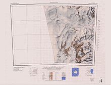
Greenville Valley is in the northwest of the Convoy Range, in the lower part of the map
205:
Greenville Valley was explored in 1957 by the New
Zealand Northern Survey Party of the
808:
217:
190:
133:
59:
588:, a freighter in the main American convoy into McMurdo Sound in the 1956-57 season.
710:
186:
245:
581:
567:
554:
529:
516:
491:
478:
453:
440:
415:
402:
377:
364:
339:
326:
301:
288:
164:
150:
100:
86:
17:
185:) is the large mainly ice-free valley lying south of Elkhorn Ridge in the
270:
604:
602:
600:
129:
124:
76:
71:
32:
209:(CTAE), 1956–58. It was named by them after the
620:
216:, a freighter in the main American convoy into
8:
680:
29:
51:
782:United States Department of the Interior
761:United States Department of the Interior
740:United States Board on Geographic Names
720:United States Board on Geographic Names
692:
668:
656:
644:
632:
608:
596:
207:Commonwealth Trans-Antarctic Expedition
7:
773:Geographic Names Information System
752:Geographic Names Information System
798:from websites or documents of the
738:from websites or documents of the
25:
712:Geographic Names of the Antarctic
794: This article incorporates
789:
734: This article incorporates
729:
50:
43:
800:United States Geological Survey
778:United States Geological Survey
757:United States Geological Survey
709:Alberts, Fred G., ed. (1995),
1:
193:, Antarctica. A lobe of the
261:GPX (secondary coordinates)
836:
586:Private Joseph F. Merrell
256:GPX (primary coordinates)
231:Map all coordinates using
37:
815:Valleys of Victoria Land
239:Download coordinates as:
220:in the 1956–57 season.
796:public domain material
736:public domain material
276:
201:Exploration and naming
302:76.6333333°S 161.15°E
274:
251:GPX (all coordinates)
27:Valley in Antarctica
621:Scuttle Valley USGS
564: /
526: /
488: /
450: /
412: /
374: /
336: /
307:-76.6333333; 161.15
298: /
160: /
96: /
568:76.833°S 160.833°E
492:76.717°S 161.000°E
454:76.717°S 160.967°E
416:76.700°S 160.950°E
378:76.667°S 161.050°E
340:76.667°S 161.100°E
277:
213:Greenville Victory
165:76.733°S 160.867°E
101:76.733°S 160.867°E
72:Highest point
195:Northwind Glacier
176:Greenville Valley
143:Greenville Valley
140:
139:
112:Greenville Valley
33:Greenville Valley
16:(Redirected from
827:
793:
792:
784:
763:
747:"Scuttle Valley"
733:
732:
728:
727:
726:
717:
696:
690:
684:
681:Voigt Ledge USGS
678:
672:
666:
660:
654:
648:
642:
636:
630:
624:
618:
612:
606:
579:
578:
576:
575:
574:
573:-76.833; 160.833
569:
565:
562:
561:
560:
557:
541:
540:
538:
537:
536:
531:
527:
524:
523:
522:
519:
503:
502:
500:
499:
498:
497:-76.717; 161.000
493:
489:
486:
485:
484:
481:
465:
464:
462:
461:
460:
459:-76.717; 160.967
455:
451:
448:
447:
446:
443:
427:
426:
424:
423:
422:
421:-76.700; 160.950
417:
413:
410:
409:
408:
405:
389:
388:
386:
385:
384:
383:-76.667; 161.050
379:
375:
372:
371:
370:
367:
351:
350:
348:
347:
346:
345:-76.667; 161.100
341:
337:
334:
333:
332:
329:
313:
312:
310:
309:
308:
303:
299:
296:
295:
294:
291:
184:
183:
181:
180:
179:
177:
172:
171:
170:-76.733; 160.867
166:
161:
158:
157:
156:
153:
120:
119:
117:
116:
115:
113:
108:
107:
106:-76.733; 160.867
102:
97:
94:
93:
92:
89:
54:
53:
47:
30:
21:
835:
834:
830:
829:
828:
826:
825:
824:
805:
804:
790:
787:
766:
745:
730:
724:
722:
715:
708:
704:
699:
691:
687:
679:
675:
667:
663:
655:
651:
643:
639:
631:
627:
619:
615:
607:
598:
594:
572:
570:
566:
563:
558:
555:
553:
551:
550:
548:
534:
532:
528:
525:
520:
517:
515:
513:
512:
510:
496:
494:
490:
487:
482:
479:
477:
475:
474:
472:
458:
456:
452:
449:
444:
441:
439:
437:
436:
434:
432:Greenville Hole
420:
418:
414:
411:
406:
403:
401:
399:
398:
396:
394:Topside Glacier
382:
380:
376:
373:
368:
365:
363:
361:
360:
358:
344:
342:
338:
335:
330:
327:
325:
323:
322:
320:
306:
304:
300:
297:
292:
289:
287:
285:
284:
282:
269:
268:
267:
266:
265:
226:
203:
175:
173:
169:
167:
163:
162:
159:
154:
151:
149:
147:
146:
111:
109:
105:
103:
99:
98:
95:
90:
87:
85:
83:
82:
67:
66:
65:
64:
63:
57:
56:
55:
28:
23:
22:
15:
12:
11:
5:
833:
831:
823:
822:
817:
807:
806:
786:
785:
764:
743:
718:(2 ed.),
705:
703:
700:
698:
697:
695:, p. 486.
685:
673:
661:
659:, p. 752.
649:
647:, p. 217.
637:
635:, p. 693.
625:
613:
611:, p. 294.
595:
593:
590:
547:
546:Merrell Valley
544:
530:76.8°S 160.8°E
509:
506:
471:
468:
433:
430:
395:
392:
357:
354:
319:
316:
281:
280:Scuttle Valley
278:
264:
263:
258:
253:
248:
242:
236:
229:
228:
227:
225:
222:
202:
199:
138:
137:
131:
127:
126:
122:
121:
80:
74:
73:
69:
68:
58:
49:
48:
42:
41:
40:
39:
38:
35:
34:
26:
24:
14:
13:
10:
9:
6:
4:
3:
2:
832:
821:
818:
816:
813:
812:
810:
803:
801:
797:
783:
779:
775:
774:
769:
768:"Voigt Ledge"
765:
762:
758:
754:
753:
748:
744:
741:
737:
721:
714:
713:
707:
706:
701:
694:
689:
686:
682:
677:
674:
671:, p. 93.
670:
665:
662:
658:
653:
650:
646:
641:
638:
634:
629:
626:
622:
617:
614:
610:
605:
603:
601:
597:
591:
589:
587:
583:
577:
545:
543:
539:
507:
505:
501:
470:Bridge Riegel
469:
467:
463:
431:
429:
425:
393:
391:
387:
356:Elkhorn Ridge
355:
353:
349:
317:
315:
311:
279:
273:
262:
259:
257:
254:
252:
249:
247:
244:
243:
241:
240:
235:
234:OpenStreetMap
232:
223:
221:
219:
218:McMurdo Sound
215:
214:
208:
200:
198:
196:
192:
191:Victoria Land
188:
182:
144:
135:
134:Victoria Land
132:
128:
123:
118:
81:
79:
75:
70:
61:
60:Victoria Land
46:
36:
31:
19:
18:Elkhorn Ridge
788:
771:
750:
723:, retrieved
711:
693:Alberts 1995
688:
676:
669:Alberts 1995
664:
657:Alberts 1995
652:
645:Alberts 1995
640:
633:Alberts 1995
628:
616:
609:Alberts 1995
585:
549:
535:-76.8; 160.8
511:
473:
435:
397:
359:
321:
283:
238:
237:
230:
212:
204:
187:Convoy Range
142:
141:
136:, Antarctica
62:, Antarctica
820:Scott Coast
571: /
533: /
508:Voigt Ledge
495: /
457: /
419: /
381: /
343: /
305: /
293:161°09′00″E
168: /
104: /
78:Coordinates
809:Categories
725:2024-01-30
592:References
582:Mount Gunn
318:Sore Thumb
290:76°38′00″S
174: (
110: (
125:Geography
559:160°50′E
521:160°48′E
483:161°00′E
445:160°58′E
407:160°57′E
369:161°03′E
331:161°06′E
224:Features
155:160°52′E
130:Location
91:160°52′E
702:Sources
556:76°50′S
518:76°48′S
480:76°43′S
442:76°43′S
404:76°42′S
366:76°40′S
328:76°40′S
152:76°44′S
88:76°44′S
716:(PDF)
211:USNS
246:KML
189:of
811::
802:.
780:,
776:,
770:,
759:,
755:,
749:,
599:^
742:.
683:.
623:.
178:)
145:(
114:)
20:)
Text is available under the Creative Commons Attribution-ShareAlike License. Additional terms may apply.