1504:
63:
47:
70:
263:
247:. The western side of the island, facing the main flow of Doubtful Sound, contains extensive rock wall habitats. Off the southern end of the island are deep kelp beds. To the east of Elizabeth Island lies a shallow channel with high water flow, containing Olphert Cove and the mouth of
344:
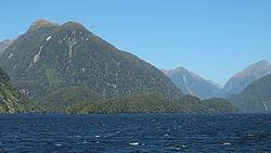
229:. It was created during the last glaciation, its narrow long shape aligned with the direction of the fiord. The island is uninhabited and entirely covered in dense native bush.
765:
760:
244:
1545:
780:
1564:
775:
770:
108:
1483:
755:
750:
348:
62:
745:
390:
1579:
740:
735:
1574:
1538:
806:
801:
689:
623:
1503:
1326:
1188:
1133:
1569:
988:
491:
248:
867:
466:
309:
1531:
1478:
943:
847:
608:
593:
583:
563:
1203:
1183:
1178:
1138:
898:
603:
543:
517:
1336:
1048:
1028:
913:
588:
1093:
1078:
998:
953:
928:
903:
842:
1422:
1311:
1280:
1158:
613:
578:
419:
383:
218:
1128:
1123:
1033:
948:
664:
649:
426:
414:
1321:
1316:
908:
507:
461:
446:
431:
301:
1168:
46:
821:
1331:
1193:
376:
1394:
206:
17:
1432:
1377:
1367:
1259:
1254:
1163:
968:
816:
811:
796:
628:
558:
471:
1447:
1389:
1362:
1341:
1023:
1003:
993:
933:
704:
573:
281:
1153:
877:
1515:
1452:
1442:
1427:
1249:
1239:
1208:
1118:
1108:
1018:
983:
978:
826:
679:
644:
481:
436:
268:
214:
96:
1558:
1437:
1384:
1173:
1148:
1088:
1083:
1068:
938:
923:
918:
872:
862:
857:
719:
618:
538:
522:
456:
451:
441:
276:
1417:
1372:
1306:
1244:
1234:
1198:
1143:
1113:
714:
699:
694:
669:
548:
476:
226:
1462:
1412:
1357:
1229:
1213:
1063:
1053:
1043:
1013:
973:
958:
852:
684:
654:
512:
222:
179:
1285:
1098:
1073:
1058:
1038:
1008:
963:
709:
674:
486:
258:
233:
123:
110:
1511:
1457:
1275:
1103:
893:
659:
568:
399:
262:
553:
368:
1290:
372:
243:
The waters surrounding
Elizabeth Island are protected by the
51:
Elizabeth Island in front of tall mountains of
Doubtful Sound
240:
in late 1822 or early 1823 (itself named for his wife).
1519:
1471:
1405:
1350:
1299:
1268:
1222:
886:
835:
789:
728:
637:
531:
500:
407:
192:
187:
171:
163:
155:
147:
139:
102:
92:
87:
37:
251:. This area is also home to black and red coral.
345:"Taipari Road (Elizabeth Island) Marine Reserve"
1539:
384:
245:Taipari Roa (Elizabeth Island) Marine Reserve
8:
32:
302:"Elizabeth Island, Southland – NZ Topo Map"
1546:
1532:
391:
377:
369:
31:
1484:New Zealand American Fiordland Expedition
69:
293:
1514:, New Zealand geography article is a
213:) is the largest island in the inner
7:
1500:
1498:
1565:Uninhabited islands of New Zealand
1453:Te Wahipounamu World Heritage Site
333:(9th ed.). 1994. p. 452.
331:Discover New Zealand:A Wises Guide
143:0.6 km (0.23 sq mi)
25:
1502:
766:Taumoana (Five Finger Peninsula)
690:Lake McKerrow / Whakatipu Waitai
261:
232:The island was named by Captain
68:
61:
45:
761:Taipari Roa (Elizabeth Island)
1:
781:Te Tapuwae o Hua (Long Sound)
492:Rakituma / Preservation Inlet
18:Elizabeth Island, New Zealand
1518:. You can help Knowledge by
310:Land Information New Zealand
1479:Fiordland Islands programme
776:Te Hapua (Sutherland Sound)
771:Te Awaatu Channel (The Gut)
1596:
1497:
1472:Programmes and expeditions
756:Piopiotahi (Milford Sound)
751:Moana Uta (Wet Jacket Arm)
349:Department of Conservation
159:0.4 km (0.25 mi)
151:2.6 km (1.62 mi)
1580:Fiordland geography stubs
1337:Puysegur Point Lighthouse
176:
56:
44:
167:117 m (384 ft)
1575:Fiordland National Park
1423:Fiordland National Park
1312:Manapouri Power Station
219:Fiordland National Park
746:Kutu Parera (Gaer Arm)
415:Doubtful Sound / Patea
210:
164:Highest elevation
124:45.41667°S 167.12083°E
1322:Monowai Power Station
1317:Milford Sound Airport
462:Tamatea / Dusky Sound
447:Taiari / Chalky Inlet
432:Hinenui / Nancy Sound
27:Island in New Zealand
1570:Islands of Fiordland
129:-45.41667; 167.12083
1034:John o'Groats River
822:Murchison Mountains
741:Kahukura (Gold Arm)
427:Hāwea / Bligh Sound
120: /
34:
1332:Port Craig tramway
1194:Wild Natives River
1169:Wairaurāhiri River
807:Humboldt Mountains
802:Franklin Mountains
736:Hawea (Clio Rocks)
1527:
1526:
1492:
1491:
1395:Routeburn Classic
624:Resolution Island
200:
199:
16:(Redirected from
1587:
1548:
1541:
1534:
1506:
1499:
1433:Hollyford Valley
1378:Kepler Challenge
1368:Hump Ridge Track
1260:Sutherland Falls
1255:Lady Alice Falls
1189:Whitewater River
1134:Stillwater River
969:Dry Awarua River
868:Mount Richardson
817:Kepler Mountains
812:Hunter Mountains
797:Darran Mountains
629:Secretary Island
599:Elizabeth Island
559:Belle Vue Island
472:Sutherland Sound
393:
386:
379:
370:
360:
359:
357:
355:
341:
335:
334:
327:
321:
320:
318:
316:
298:
271:
266:
265:
203:Elizabeth Island
135:
134:
132:
131:
130:
125:
121:
118:
117:
116:
113:
76:Elizabeth Island
72:
71:
65:
49:
35:
33:Elizabeth Island
21:
1595:
1594:
1590:
1589:
1588:
1586:
1585:
1584:
1555:
1554:
1553:
1552:
1495:
1493:
1488:
1467:
1448:Te Ana-au Caves
1401:
1390:Routeburn Track
1363:Hollyford Track
1346:
1342:Te Anau Airport
1295:
1264:
1218:
1024:Hollyford River
1004:Glaisnock River
994:Forgotten River
989:Elizabeth River
934:Cavendish River
882:
848:Mount Edgecumbe
831:
790:Mountain ranges
785:
729:Marine reserves
724:
705:Lake Poteriteri
633:
574:Buncrana Island
564:Breaksea Island
527:
496:
403:
397:
366:
364:
363:
353:
351:
343:
342:
338:
329:
328:
324:
314:
312:
300:
299:
295:
290:
282:List of islands
267:
260:
257:
249:Elizabeth River
236:after his brig
183:
128:
126:
122:
119:
114:
111:
109:
107:
106:
83:
82:
81:
80:
79:
78:
77:
73:
52:
40:
28:
23:
22:
15:
12:
11:
5:
1593:
1591:
1583:
1582:
1577:
1572:
1567:
1557:
1556:
1551:
1550:
1543:
1536:
1528:
1525:
1524:
1507:
1490:
1489:
1487:
1486:
1481:
1475:
1473:
1469:
1468:
1466:
1465:
1460:
1455:
1450:
1445:
1443:Puysegur Point
1440:
1435:
1430:
1428:Foveaux Strait
1425:
1420:
1415:
1409:
1407:
1406:Other features
1403:
1402:
1400:
1399:
1398:
1397:
1387:
1382:
1381:
1380:
1370:
1365:
1360:
1354:
1352:
1351:Walking tracks
1348:
1347:
1345:
1344:
1339:
1334:
1329:
1324:
1319:
1314:
1309:
1303:
1301:
1297:
1296:
1294:
1293:
1288:
1283:
1278:
1272:
1270:
1266:
1265:
1263:
1262:
1257:
1252:
1250:Humboldt Falls
1247:
1242:
1240:Grainger Falls
1237:
1232:
1226:
1224:
1220:
1219:
1217:
1216:
1211:
1209:Windward River
1206:
1201:
1196:
1191:
1186:
1181:
1176:
1171:
1166:
1161:
1156:
1151:
1146:
1141:
1136:
1131:
1126:
1121:
1119:Seaforth River
1116:
1111:
1109:Red Pyke River
1106:
1101:
1096:
1091:
1086:
1081:
1076:
1071:
1066:
1061:
1056:
1051:
1046:
1041:
1036:
1031:
1026:
1021:
1019:Gulliver River
1016:
1011:
1006:
1001:
996:
991:
986:
984:Electric River
981:
979:Eglinton River
976:
971:
966:
961:
956:
951:
946:
941:
936:
931:
926:
921:
916:
911:
906:
901:
896:
890:
888:
884:
883:
881:
880:
875:
870:
865:
860:
855:
850:
845:
839:
837:
833:
832:
830:
829:
827:Wick Mountains
824:
819:
814:
809:
804:
799:
793:
791:
787:
786:
784:
783:
778:
773:
768:
763:
758:
753:
748:
743:
738:
732:
730:
726:
725:
723:
722:
717:
712:
707:
702:
697:
692:
687:
682:
680:Lake Manapouri
677:
672:
667:
662:
657:
652:
647:
645:Lake Alabaster
641:
639:
635:
634:
632:
631:
626:
621:
616:
611:
606:
601:
596:
591:
586:
581:
576:
571:
566:
561:
556:
551:
546:
541:
535:
533:
529:
528:
526:
525:
520:
515:
510:
504:
502:
498:
497:
495:
494:
489:
484:
482:Breaksea Sound
479:
474:
469:
467:Thompson Sound
464:
459:
454:
449:
444:
439:
437:Bradshaw Sound
434:
429:
424:
423:
422:
411:
409:
405:
404:
398:
396:
395:
388:
381:
373:
362:
361:
336:
322:
292:
291:
289:
286:
285:
284:
279:
273:
272:
269:Islands portal
256:
253:
215:Doubtful Sound
198:
197:
194:
190:
189:
185:
184:
177:
174:
173:
172:Administration
169:
168:
165:
161:
160:
157:
153:
152:
149:
145:
144:
141:
137:
136:
104:
100:
99:
97:Doubtful Sound
94:
90:
89:
85:
84:
75:
74:
67:
66:
60:
59:
58:
57:
54:
53:
50:
42:
41:
38:
26:
24:
14:
13:
10:
9:
6:
4:
3:
2:
1592:
1581:
1578:
1576:
1573:
1571:
1568:
1566:
1563:
1562:
1560:
1549:
1544:
1542:
1537:
1535:
1530:
1529:
1523:
1521:
1517:
1513:
1508:
1505:
1501:
1496:
1485:
1482:
1480:
1477:
1476:
1474:
1470:
1464:
1461:
1459:
1456:
1454:
1451:
1449:
1446:
1444:
1441:
1439:
1438:McKinnon Pass
1436:
1434:
1431:
1429:
1426:
1424:
1421:
1419:
1416:
1414:
1411:
1410:
1408:
1404:
1396:
1393:
1392:
1391:
1388:
1386:
1385:Milford Track
1383:
1379:
1376:
1375:
1374:
1371:
1369:
1366:
1364:
1361:
1359:
1356:
1355:
1353:
1349:
1343:
1340:
1338:
1335:
1333:
1330:
1328:
1325:
1323:
1320:
1318:
1315:
1313:
1310:
1308:
1305:
1304:
1302:
1298:
1292:
1289:
1287:
1284:
1282:
1281:Milford Sound
1279:
1277:
1274:
1273:
1271:
1267:
1261:
1258:
1256:
1253:
1251:
1248:
1246:
1243:
1241:
1238:
1236:
1233:
1231:
1228:
1227:
1225:
1221:
1215:
1212:
1210:
1207:
1205:
1202:
1200:
1197:
1195:
1192:
1190:
1187:
1185:
1182:
1180:
1177:
1175:
1174:Waitutu River
1172:
1170:
1167:
1165:
1164:Waikōau River
1162:
1160:
1157:
1155:
1152:
1150:
1149:Transit River
1147:
1145:
1142:
1140:
1137:
1135:
1132:
1130:
1127:
1125:
1122:
1120:
1117:
1115:
1112:
1110:
1107:
1105:
1102:
1100:
1097:
1095:
1092:
1090:
1089:Pandora River
1087:
1085:
1084:Olivine River
1082:
1080:
1077:
1075:
1072:
1070:
1069:Monowai River
1067:
1065:
1062:
1060:
1057:
1055:
1052:
1050:
1047:
1045:
1042:
1040:
1037:
1035:
1032:
1030:
1027:
1025:
1022:
1020:
1017:
1015:
1012:
1010:
1007:
1005:
1002:
1000:
997:
995:
992:
990:
987:
985:
982:
980:
977:
975:
972:
970:
967:
965:
962:
960:
957:
955:
952:
950:
947:
945:
944:Clinton River
942:
940:
939:Cleddau River
937:
935:
932:
930:
927:
925:
924:Carrick River
922:
920:
919:Camelot River
917:
915:
912:
910:
907:
905:
902:
900:
897:
895:
892:
891:
889:
885:
879:
876:
874:
873:Mount Titiroa
871:
869:
866:
864:
863:Mount Moturau
861:
859:
858:Mount Luxmore
856:
854:
851:
849:
846:
844:
841:
840:
838:
834:
828:
825:
823:
820:
818:
815:
813:
810:
808:
805:
803:
800:
798:
795:
794:
792:
788:
782:
779:
777:
774:
772:
769:
767:
764:
762:
759:
757:
754:
752:
749:
747:
744:
742:
739:
737:
734:
733:
731:
727:
721:
720:Waiuna Lagoon
718:
716:
713:
711:
708:
706:
703:
701:
698:
696:
693:
691:
688:
686:
683:
681:
678:
676:
673:
671:
668:
666:
663:
661:
658:
656:
653:
651:
648:
646:
643:
642:
640:
636:
630:
627:
625:
622:
620:
619:Pomona Island
617:
615:
612:
610:
609:Indian Island
607:
605:
602:
600:
597:
595:
594:Cooper Island
592:
590:
587:
585:
584:Chalky Island
582:
580:
579:Centre Island
577:
575:
572:
570:
567:
565:
562:
560:
557:
555:
552:
550:
547:
545:
542:
540:
539:Anchor Island
537:
536:
534:
530:
524:
523:Te Waewae Bay
521:
519:
518:Pearl Harbour
516:
514:
511:
509:
506:
505:
503:
499:
493:
490:
488:
485:
483:
480:
478:
475:
473:
470:
468:
465:
463:
460:
458:
457:Caswell Sound
455:
453:
452:Charles Sound
450:
448:
445:
443:
442:Milford Sound
440:
438:
435:
433:
430:
428:
425:
421:
418:
417:
416:
413:
412:
410:
406:
402:, New Zealand
401:
394:
389:
387:
382:
380:
375:
374:
371:
367:
350:
346:
340:
337:
332:
326:
323:
311:
307:
303:
297:
294:
287:
283:
280:
278:
277:Desert island
275:
274:
270:
264:
259:
254:
252:
250:
246:
241:
239:
235:
230:
228:
224:
220:
216:
212:
208:
204:
195:
191:
186:
182:
181:
175:
170:
166:
162:
158:
154:
150:
146:
142:
138:
133:
105:
101:
98:
95:
91:
86:
64:
55:
48:
43:
36:
30:
19:
1520:expanding it
1509:
1494:
1418:Awarua Point
1373:Kepler Track
1327:Milford Road
1307:Homer Tunnel
1245:Helena Falls
1235:Browne Falls
1204:Wilson River
1199:Wilmot River
1184:Wapiti River
1179:Walker River
1154:Tūtoko River
1144:Thurso River
1139:Talbot River
1114:Rooney River
1079:Newton River
999:George River
929:Castle River
904:Awarua River
899:Arthur River
878:Mount Tūtoko
715:Lake Te Anau
700:Lake Monowai
695:Mirror Lakes
670:Lake Hauroko
604:Great Island
598:
549:Bauza Island
544:Arran Island
477:George Sound
365:
352:. Retrieved
339:
330:
325:
313:. Retrieved
305:
296:
242:
237:
231:
227:South Island
202:
201:
188:Demographics
178:
29:
1463:Wilmot Pass
1413:Aurora Cave
1358:Dusky Track
1269:Settlements
1230:Bowen Falls
1214:Wolff River
1159:Waiau River
1064:Misty River
1054:Lyvia River
1049:Light River
1044:Kaipo River
1029:Irene River
1014:Grebe River
974:Edith River
959:Donne River
914:Bowen River
853:Mount Grono
685:Lake Marian
655:Lake Fergus
614:Long Island
589:Coal Island
513:Martins Bay
354:10 November
315:10 November
306:NZ Topo Map
223:New Zealand
180:New Zealand
127: /
103:Coordinates
1559:Categories
1300:Structures
1286:Port Craig
1223:Waterfalls
1129:Spey River
1124:Shag River
1099:Pyke River
1094:Pitt River
1074:Namu River
1059:Mike River
1039:Juno River
1009:Gray River
964:Doon River
954:Dark River
949:Coal River
843:Mitre Peak
710:Lake Quill
675:Lake Innes
665:Green Lake
650:Lake Alice
487:Dagg Sound
288:References
234:John Grono
193:Population
115:167°7′15″E
1512:Fiordland
1458:West Cape
1276:Manapouri
1104:Rea River
909:Big River
894:Aan River
836:Mountains
660:Lake Gunn
569:Brig Rock
420:Deep Cove
400:Fiordland
238:Elisabeth
211:Pōkaikōkō
112:45°25′0″S
88:Geography
39:Pōkaikōkō
554:Bay Rock
255:See also
93:Location
1291:Te Anau
532:Islands
508:Big Bay
887:Rivers
408:Fiords
148:Length
1510:This
638:Lakes
221:, in
217:, in
207:Māori
156:Width
1516:stub
501:Bays
356:2016
317:2016
140:Area
225:'s
1561::
347:.
308:.
304:.
209::
1547:e
1540:t
1533:v
1522:.
392:e
385:t
378:v
358:.
319:.
205:(
196:0
20:)
Text is available under the Creative Commons Attribution-ShareAlike License. Additional terms may apply.