931:
76:
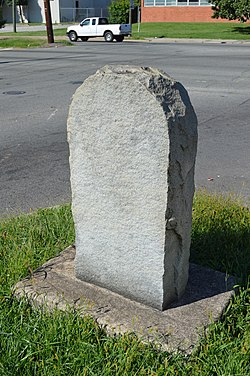
286:. It is one of 16 erected in Virginia along the Jefferson Davis Highway between 1927 and 1947. The marker is an inscribed granite slab with smooth flat faces and rough-cut edges. It measures 47 inches tall, 25 inches wide and 12 inches thick. The stone is engraved with the text "Jefferson Davis Highway This tree marks the site of Battery 17 of the inner defenses of Richmond, 1862-65, and is planted in soil taken from battlefields A memorial to Confederate Soldiers by the Elliott Grays Chapter U.D.C. 1929."
101:
59:
108:
83:
938:
131:
1315:
1310:
1300:
810:
765:
685:
805:
800:
675:
905:
870:
820:
790:
695:
550:
540:
865:
760:
735:
690:
645:
900:
855:
840:
835:
745:
680:
625:
570:
520:
475:
979:
740:
720:
700:
630:
615:
580:
575:
545:
510:
505:
480:
460:
455:
1280:
969:
890:
875:
825:
795:
770:
755:
670:
610:
605:
595:
565:
530:
525:
515:
450:
421:
1122:
1014:
845:
830:
815:
785:
730:
725:
710:
660:
655:
650:
635:
590:
535:
495:
485:
470:
1054:
895:
885:
775:
750:
715:
640:
555:
465:
1153:
1132:
1064:
1059:
1029:
1004:
915:
880:
860:
850:
665:
620:
600:
585:
560:
500:
964:
920:
910:
780:
490:
1285:
1137:
1127:
1087:
1079:
974:
954:
705:
1320:
1044:
1039:
984:
1305:
1212:
1112:
1097:
1049:
1034:
1009:
989:
1117:
1102:
1092:
1069:
1024:
999:
994:
959:
1074:
1107:
1019:
414:
1330:
434:
407:
1275:
154:
1270:
1181:
1176:
1246:
100:
75:
1158:
296:
The website
Roadside America calls this the "Highway Marker to a Dead Confederate Tree", pointing out that the tree mentioned in the inscription died decades ago.
1290:
1265:
1186:
214:
340:
1239:
430:
321:
290:
36:
367:
283:
1232:
1295:
376:
209:
45:
271:
134:
275:
138:
1171:
368:"National Register of Historic Places Inventory/Nomination: Elliott Grays Marker-Jefferson Davis Highway"
1325:
1191:
399:
326:
344:
279:
142:
1316:
Transportation buildings and structures on the
National Register of Historic Places in Virginia
1216:
1311:
Road transportation buildings and structures on the
National Register of Historic Places
227:
1259:
58:
1301:
Monuments and memorials on the
National Register of Historic Places in Virginia
215:
UDC Commemorative
Highway Markers along the Jefferson Davis Highway in Virginia
169:
156:
389:
937:
1213:
property in
Richmond, Virginia on the National Register of Historic Places
107:
82:
1281:
Confederate States of
America monuments and memorials in Virginia
316:
390:"South Richmond, VA - Highway Marker to a Dead Confederate Tree"
403:
1286:
Individual signs on the
National Register of Historic Places
1321:
United
Daughters of the Confederacy monuments and memorials
343:. Virginia Department of Historic Resources. Archived from
1306:
National
Register of Historic Places in Richmond, Virginia
1220:
1177:
History of the National Register of Historic Places
1146:
945:
441:
257:
249:
244:
233:
220:
208:
193:
185:
148:
124:
1331:Richmond, Virginia Registered Historic Place stubs
1276:Buildings and structures in Richmond, Virginia
1240:
415:
8:
373:. Virginia Department of Historic Resources.
268:Elliott Grays Marker-Jefferson Davis Highway
29:Elliott Grays Marker-Jefferson Davis Highway
1271:Buildings and structures completed in 1929
1247:
1233:
422:
408:
400:
57:
431:U.S. National Register of Historic Places
37:U.S. National Register of Historic Places
305:
317:"National Register Information System"
311:
309:
270:is a historic route marker located on
20:
1291:Individual signs in the United States
7:
1208:
1206:
322:National Register of Historic Places
291:National Register of Historic Places
284:United Daughters of the Confederacy
1219:. You can help Knowledge (XXG) by
14:
282:. It was erected in 1929, by the
936:
929:
366:Snead, Ruth D. (February 2006).
129:
106:
99:
81:
74:
1266:1929 establishments in Virginia
189:Less than 1 acre (0.40 ha)
235:
222:
1:
341:"Virginia Landmarks Register"
115:Show map of the United States
18:United States historic place
1159:National Historic Landmarks
46:Virginia Landmarks Register
1347:
1205:
1167:
927:
221:NRHP reference
128:Jct. of Ingram Ave., and
68:
56:
52:
43:
34:
27:
23:
1296:Jefferson Davis Highway
377:Accompanying two photos
276:Jefferson Davis Highway
170:37.503358°N 77.446610°W
139:Jefferson Davis Highway
1172:Keeper of the Register
1084:Poquoson (no listings)
1211:This article about a
1192:Contributing property
347:on September 21, 2013
327:National Park Service
289:It was listed on the
175:37.503358; -77.446610
90:Show map of Virginia
258:Designated VLR
166: /
280:Richmond, Virginia
143:Richmond, Virginia
63:Rear of the marker
1228:
1227:
1200:
1199:
1187:Historic district
265:
264:
245:Significant dates
1338:
1249:
1242:
1235:
1207:
980:Colonial Heights
940:
933:
932:
424:
417:
410:
401:
394:
393:
386:
380:
374:
372:
363:
357:
356:
354:
352:
337:
331:
330:
313:
237:
224:
204:
202:
181:
180:
178:
177:
176:
171:
167:
164:
163:
162:
159:
133:
132:
116:
110:
109:
103:
91:
85:
84:
78:
61:
21:
1346:
1345:
1341:
1340:
1339:
1337:
1336:
1335:
1256:
1255:
1254:
1253:
1203:
1201:
1196:
1163:
1142:
970:Charlottesville
947:
941:
935:
934:
930:
925:
443:
437:
428:
398:
397:
388:
387:
383:
370:
365:
364:
360:
350:
348:
339:
338:
334:
329:. July 9, 2010.
315:
314:
307:
302:
253:August 31, 2006
200:
198:
174:
172:
168:
165:
160:
157:
155:
153:
152:
130:
120:
119:
118:
117:
114:
113:
112:
111:
94:
93:
92:
89:
88:
87:
86:
64:
48:
39:
30:
19:
12:
11:
5:
1344:
1342:
1334:
1333:
1328:
1323:
1318:
1313:
1308:
1303:
1298:
1293:
1288:
1283:
1278:
1273:
1268:
1258:
1257:
1252:
1251:
1244:
1237:
1229:
1226:
1225:
1198:
1197:
1195:
1194:
1189:
1184:
1182:Property types
1179:
1174:
1168:
1165:
1164:
1162:
1161:
1156:
1150:
1148:
1144:
1143:
1141:
1140:
1135:
1130:
1125:
1123:Virginia Beach
1120:
1115:
1110:
1105:
1100:
1095:
1090:
1085:
1082:
1077:
1072:
1067:
1062:
1057:
1052:
1047:
1042:
1037:
1032:
1027:
1022:
1017:
1015:Fredericksburg
1012:
1007:
1002:
997:
992:
987:
982:
977:
972:
967:
962:
957:
951:
949:
943:
942:
928:
926:
924:
923:
918:
913:
908:
903:
898:
893:
888:
883:
878:
873:
868:
863:
858:
853:
848:
843:
838:
833:
828:
823:
818:
813:
811:Prince William
808:
803:
798:
793:
788:
783:
778:
773:
768:
766:Northumberland
763:
758:
753:
748:
743:
738:
733:
728:
723:
718:
713:
708:
703:
698:
693:
688:
686:King and Queen
683:
678:
673:
668:
663:
658:
653:
648:
643:
638:
633:
628:
623:
618:
613:
608:
603:
598:
593:
588:
583:
578:
573:
568:
563:
558:
553:
548:
543:
538:
533:
528:
523:
518:
513:
508:
503:
498:
493:
488:
483:
478:
473:
468:
463:
458:
453:
447:
445:
439:
438:
429:
427:
426:
419:
412:
404:
396:
395:
381:
358:
332:
304:
303:
301:
298:
263:
262:
259:
255:
254:
251:
247:
246:
242:
241:
238:
231:
230:
225:
218:
217:
212:
206:
205:
195:
191:
190:
187:
183:
182:
150:
146:
145:
126:
122:
121:
105:
104:
98:
97:
96:
95:
80:
79:
73:
72:
71:
70:
69:
66:
65:
62:
54:
53:
50:
49:
44:
41:
40:
35:
32:
31:
28:
25:
24:
17:
13:
10:
9:
6:
4:
3:
2:
1343:
1332:
1329:
1327:
1324:
1322:
1319:
1317:
1314:
1312:
1309:
1307:
1304:
1302:
1299:
1297:
1294:
1292:
1289:
1287:
1284:
1282:
1279:
1277:
1274:
1272:
1269:
1267:
1264:
1263:
1261:
1250:
1245:
1243:
1238:
1236:
1231:
1230:
1224:
1222:
1218:
1214:
1209:
1204:
1193:
1190:
1188:
1185:
1183:
1180:
1178:
1175:
1173:
1170:
1169:
1166:
1160:
1157:
1155:
1152:
1151:
1149:
1145:
1139:
1136:
1134:
1131:
1129:
1126:
1124:
1121:
1119:
1116:
1114:
1111:
1109:
1106:
1104:
1101:
1099:
1096:
1094:
1091:
1089:
1086:
1083:
1081:
1078:
1076:
1073:
1071:
1068:
1066:
1063:
1061:
1058:
1056:
1055:Manassas Park
1053:
1051:
1048:
1046:
1043:
1041:
1038:
1036:
1033:
1031:
1028:
1026:
1023:
1021:
1018:
1016:
1013:
1011:
1008:
1006:
1003:
1001:
998:
996:
993:
991:
988:
986:
983:
981:
978:
976:
973:
971:
968:
966:
963:
961:
958:
956:
953:
952:
950:
944:
939:
922:
919:
917:
914:
912:
909:
907:
904:
902:
899:
897:
894:
892:
889:
887:
884:
882:
879:
877:
874:
872:
869:
867:
864:
862:
859:
857:
854:
852:
849:
847:
844:
842:
839:
837:
834:
832:
829:
827:
824:
822:
819:
817:
814:
812:
809:
807:
806:Prince George
804:
802:
801:Prince Edward
799:
797:
794:
792:
789:
787:
784:
782:
779:
777:
774:
772:
769:
767:
764:
762:
759:
757:
754:
752:
749:
747:
744:
742:
739:
737:
734:
732:
729:
727:
724:
722:
719:
717:
714:
712:
709:
707:
704:
702:
699:
697:
694:
692:
689:
687:
684:
682:
679:
677:
676:Isle Of Wight
674:
672:
669:
667:
664:
662:
659:
657:
654:
652:
649:
647:
644:
642:
639:
637:
634:
632:
629:
627:
624:
622:
619:
617:
614:
612:
609:
607:
604:
602:
599:
597:
594:
592:
589:
587:
584:
582:
579:
577:
574:
572:
569:
567:
564:
562:
559:
557:
554:
552:
549:
547:
544:
542:
539:
537:
534:
532:
529:
527:
524:
522:
519:
517:
514:
512:
509:
507:
504:
502:
499:
497:
494:
492:
489:
487:
484:
482:
479:
477:
474:
472:
469:
467:
464:
462:
459:
457:
454:
452:
449:
448:
446:
440:
436:
432:
425:
420:
418:
413:
411:
406:
405:
402:
391:
385:
382:
378:
369:
362:
359:
346:
342:
336:
333:
328:
324:
323:
318:
312:
310:
306:
299:
297:
294:
292:
287:
285:
281:
277:
273:
269:
260:
256:
252:
250:Added to NRHP
248:
243:
239:
232:
229:
226:
219:
216:
213:
211:
207:
196:
192:
188:
184:
179:
151:
147:
144:
140:
136:
127:
123:
102:
77:
67:
60:
55:
51:
47:
42:
38:
33:
26:
22:
16:
1326:U.S. Route 1
1221:expanding it
1210:
1202:
1133:Williamsburg
1065:Newport News
1060:Martinsville
1030:Harrisonburg
1005:Falls Church
906:Westmoreland
871:Spotsylvania
821:Rappahannock
791:Pittsylvania
696:King William
551:Chesterfield
541:Charles City
384:
361:
349:. Retrieved
345:the original
335:
320:
295:
288:
272:U.S. Route 1
267:
266:
261:June 8, 2006
15:
1147:Other lists
965:Buena Vista
866:Southampton
761:Northampton
736:Mecklenburg
691:King George
646:Greensville
173: /
149:Coordinates
1260:Categories
1138:Winchester
1128:Waynesboro
1088:Portsmouth
1080:Petersburg
975:Chesapeake
955:Alexandria
901:Washington
856:Shenandoah
841:Rockingham
836:Rockbridge
746:Montgomery
681:James City
626:Gloucester
571:Cumberland
521:Buckingham
476:Appomattox
300:References
161:77°26′48″W
158:37°30′12″N
1045:Lynchburg
1040:Lexington
985:Covington
741:Middlesex
721:Lunenburg
701:Lancaster
631:Goochland
616:Frederick
581:Dinwiddie
576:Dickenson
546:Charlotte
511:Brunswick
506:Botetourt
481:Arlington
461:Alleghany
456:Albemarle
444:by county
351:March 19,
293:in 2006.
234:VLR
135:US 1
1113:Staunton
1098:Richmond
1050:Manassas
1035:Hopewell
1010:Franklin
990:Danville
891:Tazewell
876:Stafford
826:Richmond
796:Powhatan
771:Nottoway
756:New Kent
671:Highland
611:Franklin
606:Fluvanna
596:Fauquier
566:Culpeper
531:Caroline
526:Campbell
516:Buchanan
451:Accomack
435:Virginia
240:127-5837
228:06000748
125:Location
1154:Bridges
1118:Suffolk
1103:Roanoke
1093:Radford
1070:Norfolk
1025:Hampton
1000:Fairfax
995:Emporia
960:Bristol
948:by city
846:Russell
831:Roanoke
816:Pulaski
786:Patrick
731:Mathews
726:Madison
711:Loudoun
661:Henrico
656:Hanover
651:Halifax
636:Grayson
591:Fairfax
536:Carroll
496:Bedford
486:Augusta
471:Amherst
199: (
1075:Norton
896:Warren
886:Sussex
776:Orange
751:Nelson
716:Louisa
641:Greene
556:Clarke
466:Amelia
1215:is a
1108:Salem
1020:Galax
946:Lists
916:Wythe
881:Surry
861:Smyth
851:Scott
666:Henry
621:Giles
601:Floyd
586:Essex
561:Craig
501:Bland
442:Lists
371:(PDF)
278:, in
274:, or
194:Built
1217:stub
921:York
911:Wise
781:Page
491:Bath
375:and
353:2013
201:1929
197:1929
186:Area
706:Lee
433:in
236:No.
223:No.
210:MPS
141:),
1262::
325:.
319:.
308:^
1248:e
1241:t
1234:v
1223:.
423:e
416:t
409:v
392:.
379:.
355:.
203:)
137:(
Text is available under the Creative Commons Attribution-ShareAlike License. Additional terms may apply.