31:
318:
330:
342:
395:
88:
460:
434:
445:
256:
project. With the completion of the
Interstate System, it is likely that the Emlenton Bridge will remain the fifth-highest bridge in the system for a significant time, behind the
252:
The
Emlenton Bridge remains the highest road bridge in Pennsylvania; with an overall span of 1,668 feet (508 m) it was the largest bridge constructed as part of the
508:
493:
488:
356:
518:
294:
The
Emlenton Bridge is actually located in three different Pennsylvania counties due to its size and the geography of the land. One side of the bridge is in
513:
241:
is higher but is technically an international bridge, not part of the
Interstate Highway system). This record was held until 1971 with the opening of the
483:
122:
351:
498:
523:
283:
The bridge was designed by the consultant
Buchart-Horn led by Ted Andrzejewski, an acquaintance of the noted bridge engineer
35:
91:
44:
303:
51:
399:
428:
238:
234:
265:
288:
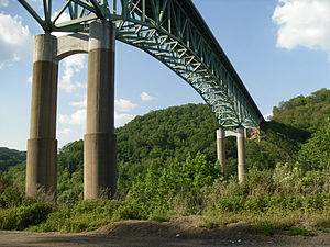
233:. With a height of 270 feet (82 m) above the river, the Emlenton Bridge was the highest bridge in the
503:
222:
111:
454:
242:
346:
273:
334:
257:
30:
253:
246:
322:
411:
317:
218:
101:
299:
295:
284:
329:
477:
261:
226:
137:
404:
269:
66:
53:
176:
394:
277:
380:. York,PA: American Canal & Transportation Center. p. 65.
214:
459:
433:
287:. The contractor of record is Brodhead Construction located in
230:
444:
408:
198:
190:
185:
175:
167:
159:
151:
143:
133:
128:
118:
107:
97:
82:
43:
21:
357:List of bridges in the United States by height
8:
405:
378:Historic Bridges of Pennsylvania (Revised)
18:
123:Pennsylvania Department of Transportation
509:Bridges on the Interstate Highway System
352:List of crossings of the Allegheny River
302:, and the southwest abutment resides in
280:, and the aforementioned Redmon Bridge.
494:Bridges in Venango County, Pennsylvania
489:Bridges in Clarion County, Pennsylvania
368:
229:at approximately mile marker 44.4 on
7:
519:1968 establishments in Pennsylvania
514:Steel bridges in the United States
14:
484:Bridges over the Allegheny River
458:
443:
432:
393:
340:
328:
316:
86:
29:
1:
420:
499:Road bridges in Pennsylvania
237:when completed in 1968 (The
16:Bridge in Pennsylvania, U.S.
540:
221:just south of the town of
524:Bridges completed in 1968
449:
438:
429:Emlenton Low Level Bridge
423:
418:
239:Lewiston-Queenston Bridge
235:Interstate Highway System
203:
28:
266:Pine Valley Creek Bridge
376:Shank, William (1990).
347:Pennsylvania portal
289:Aliquippa, Pennsylvania
155:1,668 feet (508 m)
335:Engineering portal
223:Emlenton, Pennsylvania
217:bridge that spans the
112:Emlenton, Pennsylvania
402:at Wikimedia Commons
243:Fred G. Redmon Bridge
323:Transport portal
181:270 feet (82 m)
274:Galena Creek Bridge
67:41.1743°N 79.6975°W
63: /
298:, the other is in
258:Glade Creek Bridge
38:at Emlenton Bridge
471:
470:
466:
465:
398:Media related to
254:Keystone Shortway
247:Selah, Washington
207:
206:
72:41.1743; -79.6975
531:
462:
447:
436:
421:
406:
397:
382:
381:
373:
345:
344:
343:
333:
332:
321:
320:
213:is a steel-deck
90:
89:
78:
77:
75:
74:
73:
68:
64:
61:
60:
59:
56:
33:
19:
539:
538:
534:
533:
532:
530:
529:
528:
474:
473:
472:
467:
457:
453:
442:
440:Emlenton Bridge
431:
427:
414:
412:Allegheny River
410:Bridges of the
400:Emlenton Bridge
391:
386:
385:
375:
374:
370:
365:
341:
339:
327:
315:
312:
219:Allegheny River
211:Emlenton Bridge
177:Clearance below
129:Characteristics
102:Allegheny River
87:
71:
69:
65:
62:
57:
54:
52:
50:
49:
39:
24:
23:Emlenton Bridge
17:
12:
11:
5:
537:
535:
527:
526:
521:
516:
511:
506:
501:
496:
491:
486:
476:
475:
469:
468:
464:
463:
455:Foxburg Bridge
448:
437:
419:
416:
415:
409:
390:
389:External links
387:
384:
383:
367:
366:
364:
361:
360:
359:
354:
349:
337:
325:
311:
308:
300:Clarion County
296:Venango County
285:Ralph Modjeski
205:
204:
201:
200:
196:
195:
192:
188:
187:
183:
182:
179:
173:
172:
169:
165:
164:
161:
157:
156:
153:
149:
148:
145:
141:
140:
135:
131:
130:
126:
125:
120:
116:
115:
109:
105:
104:
99:
95:
94:
84:
80:
79:
47:
41:
40:
34:
26:
25:
22:
15:
13:
10:
9:
6:
4:
3:
2:
536:
525:
522:
520:
517:
515:
512:
510:
507:
505:
504:Interstate 80
502:
500:
497:
495:
492:
490:
487:
485:
482:
481:
479:
461:
456:
452:
446:
441:
435:
430:
426:
422:
417:
413:
407:
403:
401:
396:
388:
379:
372:
369:
362:
358:
355:
353:
350:
348:
338:
336:
331:
326:
324:
319:
314:
313:
309:
307:
305:
304:Butler County
301:
297:
292:
290:
286:
281:
279:
275:
271:
267:
263:
262:West Virginia
259:
255:
250:
248:
244:
240:
236:
232:
228:
227:United States
224:
220:
216:
212:
202:
197:
193:
189:
184:
180:
178:
174:
170:
166:
162:
158:
154:
150:
146:
142:
139:
136:
132:
127:
124:
121:
119:Maintained by
117:
113:
110:
106:
103:
100:
96:
93:
85:
81:
76:
48:
46:
42:
37:
36:Interstate 80
32:
27:
20:
450:
439:
424:
392:
377:
371:
293:
282:
251:
210:
208:
168:Longest span
152:Total length
138:Truss bridge
70: /
45:Coordinates
478:Categories
451:Downstream
363:References
270:California
58:79°41′51″W
55:41°10′27″N
425:Upstream
310:See also
199:Location
144:Material
186:History
163:4 lanes
98:Crosses
83:Carries
278:Nevada
272:, the
264:, the
191:Opened
134:Design
114:, U.S.
108:Locale
245:near
215:truss
171:165 m
160:Width
147:Steel
231:I-80
209:The
194:1968
92:I-80
276:in
268:in
260:in
480::
306:.
291:.
249:.
225:,
Text is available under the Creative Commons Attribution-ShareAlike License. Additional terms may apply.