228:
45:
29:
52:
251:
207:
Since the 19th century, observers have deemed
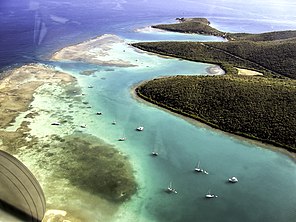
Ensenada Honda among the safest Caribbean harbors. Its irregular coastline features rocky cliffs, sandy beaches, and mangrove forests. Three smaller inlets gate the cavernous cove: "Malena" and "Dakity" to the west, and "Mosquito" to the east. A number of
220:
For most of the 20th century (1902-1975) the bay served as grounds for military training, as wreckage left from the time reveals. Explosions and the resulting contamination left pulverized underwater craters and diminished the health of sea life. But low-tech, community-based programs and coral
361:
234:
44:
144:
227:
221:
grafting have expanded the reefs' fields and increased their bio-diversity. The bay is today an eco-tourist destination, celebrated for its turtles, and the center of the local fishing industry.
85:
212:
specimens inhabit the area around
Culebra, and some communities have flourished at the very bay's entrance. They form bars barely above sea level and block portions of its opening.
432:"Bomb-cratered coral reefs in Puerto Rico, the untold story about a novel habitat: from reef destruction to community-based ecological rehabilitation"
264:
159:
459:
148:
279:
401:
307:, however, laid waste to much of Culebra and sank about 100 of the 300 ships that have taken refuge in the bay.
28:
192:
172:
134:
71:
431:
386:
256:
333:"Progress of Studies on the Impact of Hurricane Hugo on the Coastal Resources of Puerto Rico"
380:
304:
284:
453:
117:
274:
269:
191:) and "Bahía Honda" for its elongated shape, is the largest inlet on the island of
332:
196:
246:
382:
Catalogue of the madreporarian corals in the
British Museum (Natural History)
100:
87:
402:"Culebra Community Watershed Action Plan For Water Quality and Coral Reefs"
209:
342:. U.S. Department of the Interior: Geological Survey. pp. 8–12
129:
122:
51:
237:
View of
Ensenada Honda from Mt. Resaca, Culebra Island, P.R.
331:Schwab, William C. and Rafael W. Rodriguez (1992).
168:
158:
154:
140:
128:
116:
77:
67:
21:
145:Department of Natural and Environmental Resources
78:
22:Ensenada Honda (Deep Cove), Culebra, Puerto Rico
362:"Las posesiones Españolas y el Canal de Panamá"
8:
187:), also known as "Puerto Grande" (English:
18:
320:
296:
366:Boletín de la Real sociedad geográfica
326:
324:
59:Ensenada Honda in Culebra, Puerto Rico
7:
430:Hernández-Delgado, Edwin A. (2014).
16:Beach in Culebra Island, Puerto Rico
385:. London: British Museum. pp.
265:Ensenada Honda (Ceiba, Puerto Rico)
14:
400:Sturm, Paul; et al. (2014).
249:
226:
50:
43:
27:
1:
66:
436:Revista de Biología Tropical
149:Puerto Rico Ports Authority
476:
280:Culebra Island giant anole
33:Entrance to Ensenada Honda
188:
184:
38:
26:
101:18.302694°N 65.286306°W
379:Brook, George (1893).
216:Environmental history
106:18.302694; -65.286306
460:Culebra, Puerto Rico
173:Culebra, Puerto Rico
135:North Atlantic Ocean
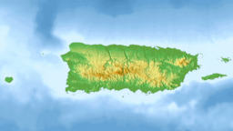
72:Culebra, Puerto Rico
97: /
257:Puerto Rico portal
178:
177:
130:Ocean/sea sources
467:
444:
443:
427:
421:
420:
418:
416:
406:
397:
391:
390:
376:
370:
369:
358:
352:
351:
349:
347:
337:
328:
308:
301:
259:
254:
253:
252:
230:
190:
186:
131:
112:
111:
109:
108:
107:
102:
98:
95:
94:
93:
90:
80:
54:
53:
47:
31:
19:
475:
474:
470:
469:
468:
466:
465:
464:
450:
449:
448:
447:
429:
428:
424:
414:
412:
404:
399:
398:
394:
378:
377:
373:
360:
359:
355:
345:
343:
335:
330:
329:
322:
317:
312:
311:
302:
298:
293:
255:
250:
248:
245:
240:
239:
238:
236:
231:
218:
205:
141:Managing agency
105:
103:
99:
96:
91:
88:
86:
84:
83:
63:
62:
61:
60:
57:
56:
55:
34:
17:
12:
11:
5:
473:
471:
463:
462:
452:
451:
446:
445:
422:
392:
371:
368:: 354–8. 1887.
353:
319:
318:
316:
313:
310:
309:
305:Hurricane Hugo
295:
294:
292:
289:
288:
287:
285:Flamenco Beach
282:
277:
272:
267:
261:
260:
244:
241:
233:
232:
225:
224:
223:
217:
214:
204:
201:
181:Ensenada Honda
176:
175:
170:
166:
165:
162:
156:
155:
152:
151:
142:
138:
137:
132:
126:
125:
120:
114:
113:
81:
75:
74:
69:
65:
64:
58:
49:
48:
42:
41:
40:
39:
36:
35:
32:
24:
23:
15:
13:
10:
9:
6:
4:
3:
2:
472:
461:
458:
457:
455:
441:
437:
433:
426:
423:
410:
403:
396:
393:
388:
384:
383:
375:
372:
367:
363:
357:
354:
341:
334:
327:
325:
321:
314:
306:
300:
297:
290:
286:
283:
281:
278:
276:
273:
271:
268:
266:
263:
262:
258:
247:
242:
235:
229:
222:
215:
213:
211:
202:
200:
198:
194:
182:
174:
171:
167:
163:
161:
157:
153:
150:
146:
143:
139:
136:
133:
127:
124:
121:
119:
115:
110:
82:
76:
73:
70:
46:
37:
30:
25:
20:
439:
435:
425:
413:. Retrieved
408:
395:
381:
374:
365:
356:
346:February 10,
344:. Retrieved
339:
299:
275:Mayaguez Bay
270:San Juan Bay
219:
206:
180:
179:
92:65°17′10.7″W
89:18°18′09.7″N
442:(Suppl. 3).
415:February 9,
197:Puerto Rico
169:Settlements
164:Cayo Pirata
104: /
79:Coordinates
315:References
183:(English:
208:distinct
203:Geography
185:Deep Cove
454:Category
303:In 1989
243:See also
189:Big Port
68:Location
193:Culebra
160:Islands
411:. NOOA
409:Report
340:Report
405:(PDF)
336:(PDF)
291:Notes
210:coral
417:2016
348:2016
118:Type
123:Bay
456::
440:62
438:.
434:.
407:.
387:63
364:.
338:.
323:^
199:.
195:,
147:,
419:.
389:.
350:.
Text is available under the Creative Commons Attribution-ShareAlike License. Additional terms may apply.