75:
in a general northeasterly direction, with a width of about 1 mile. There are numerous small islands in the sound, and two large ones, one on each side, about midway of its length. From Ernest Sound, two arms extend northwestward; and joining near the mouth of
Stikine River inclose Wrangell Island. The southwest arm is called Zimovia Strait. The southeast part of the northeast arm is called Blake Channel and the northwest part Eastern Passage. A passage to Wrangell through Ernest Sound, Blake Channel, and Eastern Passage is practicable, and is sometimes used. Small craft use Zimovia Strait frequently. In addition, the main part of the bay as far north as Eaton Point, a channel % to 1% miles wide from Eaton Point to the north end of Deer Island, and the channel from Deer Island to the junction of Blake Channel and Bradfield Canal, and through Blake Channel and Eastern Passage, have been examined by means of a
20:
74:
Ernest Sound is the large body of water which opens from
Clarence Strait between Lemesurier Point and Onslow Point, with a width of about 4 miles between the points. Its general direction is northward for 25 miles to Point Warde; from this point, under the name of Bradfield Canal; it extends 17 miles
124:
79:. The principal dangers in the main part of Ernest Sound are McHenry Ledge, with a depth of 3 feet; and an 18-foot rock off the entrance to Union Bay.
211:
19:
167:
63:
206:
51:
216:
95:
59:
76:
118:
155:
55:
31:
43:
39:
38:. It extends 48 kilometres (30 mi) southwest, from the mouth of Bradfield Canal to
200:
47:
35:
108:
182:
169:
96:
U.S. Geological Survey
Geographic Names Information System: Ernest Sound
157:
United States Coast Pilot: Alaska. Dixon
Entrance to Yakutat Bay. Pt. 1
110:
A voyage of discovery to the North
Pacific ocean, and round the world
50:
from the mainland. It was first traversed and charted in 1793 by
160:(Public domain ed.). U.S. Government Printing Office.
62:. Vancouver later named it "Prince Ernest's Sound", after
137:
107:Vancouver, George, and John Vancouver (1801).
8:
123:: CS1 maint: multiple names: authors list (
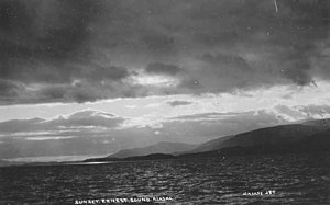
23:Sunset at Ernest Sound, Alaska, circa 1908
18:
88:
116:
7:
14:
64:Prince Ernest, Duke of Cumberland
154:Department of Commerce (1917).
1:
212:Straits of Wrangell, Alaska
138:Department of Commerce 1917
233:
66:(later King of Hanover).
113:. London: J. Stockdale.
58:'s officers during his
183:55.99389°N 132.07500°W
24:
22:
188:55.99389; -132.07500
179: /
60:1791-95 expedition
25:
207:Straits of Alaska
224:
217:Sounds of Alaska
194:
193:
191:
190:
189:
184:
180:
177:
176:
175:
172:
161:
141:
135:
129:
128:
122:
114:
104:
98:
93:
77:wire-drag survey
56:George Vancouver
32:Southeast Alaska
16:Strait in Alaska
232:
231:
227:
226:
225:
223:
222:
221:
197:
196:
187:
185:
181:
178:
173:
170:
168:
166:
165:
153:
145:
144:
136:
132:
115:
106:
105:
101:
94:
90:
85:
72:
52:James Johnstone
40:Clarence Strait
30:is a strait in
17:
12:
11:
5:
230:
228:
220:
219:
214:
209:
199:
198:
163:
162:
150:
149:
143:
142:
130:
99:
87:
86:
84:
81:
71:
68:
48:Etolin Islands
15:
13:
10:
9:
6:
4:
3:
2:
229:
218:
215:
213:
210:
208:
205:
204:
202:
195:
192:
159:
158:
152:
151:
147:
146:
140:, p. 91.
139:
134:
131:
126:
120:
112:
111:
103:
100:
97:
92:
89:
82:
80:
78:
69:
67:
65:
61:
57:
53:
49:
45:
42:, separating
41:
37:
33:
29:
21:
164:
156:
148:Bibliography
133:
109:
102:
91:
73:
28:Ernest Sound
27:
26:
186: /
174:132°04′30″W
201:Categories
171:55°59′38″N
83:References
119:cite book
70:Geography
54:, one of
44:Wrangell
36:U.S.A
125:link
46:and
203::
121:}}
117:{{
34:,
127:)
Text is available under the Creative Commons Attribution-ShareAlike License. Additional terms may apply.