645:
62:
42:
69:
355:
In the CDP, the population was spread out, with 9.4% under the age of 18, 6.3% from 18 to 24, 3.1% from 25 to 44, 50.0% from 45 to 64, and 31.3% who were 65 years of age or older. The median age was 57 years. For every 100 females, there were 88.2 males. For every 100 females age 18 and over, there
351:
living together, and 25.0% were non-families. 18.8% of all households were made up of individuals, and 6.3% had someone living alone who was 65 years of age or older. The average household size was 2.00 and the average family size was 2.25.
789:
383:, a local settler. In 1946 the Esterbrook Community Church (one of 29 mission churches in the Episcopal Missionary District of Wyoming) was built with a window behind the altar having a view to
583:
359:
The median income for a household in the CDP was $ 33,750, and the median income for a family was $ 33,750. Males had a median income of $ 0 versus $ 0 for females. The
340:
was 9.4 people per square mile (3.6/km). There were 102 housing units at an average density of 30.1/sq mi (11.6/km). The racial makeup of the CDP was 100.00%
784:
436:
93:
396:
532:
263:
576:
512:
41:
61:
273:
569:
490:
561:
400:
305:
546:
465:
321:
147:
309:
593:
297:
251:
152:
125:
683:
293:
32:
754:
673:
347:
There were 16 households, out of which 6.3% had children under the age of 18 living with them, 75.0% were
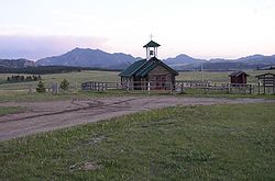
668:
376:
761:
726:
236:
706:
380:
341:
716:
519:
337:
226:
663:
360:
741:
634:
615:
412:
731:
655:
626:
336:
of 2000, there were 32 people, 16 households, and 12 families residing in the CDP. The
778:
736:
721:
696:
256:
417:
384:
364:
47:
608:
135:
324:, the CDP has a total area of 3.4 square miles (8.8 km), all land.
108:
95:
363:
for the CDP was $ 15,918. None of the population or families were below the
217:
348:
301:
289:
140:
333:
513:"2020 CENSUS - SCHOOL DISTRICT REFERENCE MAP: Converse County, WY"
243:
222:
565:
395:
Public education in the community of
Esterbrook is provided by
375:
Esterbrook, founded in 1896 as a mining city, is named after
643:
486:
461:
551:
556:
399:. Zoned campuses include White School (grades K-8) and
790:
Census-designated places in
Converse County, Wyoming
705:
682:
654:
625:
437:"2010 City Population and Housing Occupancy Status"
272:
262:
250:
233:
216:
208:
200:
195:
187:
179:
171:
163:
158:
146:
134:
124:
23:
577:
8:
68:
584:
570:
562:
20:
552:HR Wilderness Camp in Esterbrook Wyoming
428:
261:
249:
215:
194:
186:
157:
123:
88:
54:
38:
456:
454:
271:
232:
207:
199:
178:
170:
162:
145:
133:
7:
785:Census-designated places in Wyoming
592:Municipalities and communities of
397:Converse County School District #1
14:
183:0.0 sq mi (0.0 km)
175:3.4 sq mi (8.8 km)
167:3.4 sq mi (8.8 km)
557:The Episcopal Diocese of Wyoming
292:, and the locus of a same-named
67:
60:
40:
491:United States Geological Survey
308:. The population was 52 at the
81:Location of Esterbrook, Wyoming
487:"US Board on Geographic Names"
1:
379:, which was named after Mrs.
18:CDP in Wyoming, United States
547:Esterbrook at Wyoming places
306:Medicine Bow National Forest
191:6,516 ft (1,986 m)
466:United States Census Bureau
322:United States Census Bureau
806:
750:
641:
606:
89:
55:
39:
30:
595:Converse County, Wyoming
304:, United States in the
294:census-designated place
648:
212:15/sq mi (5.9/km)
109:42.40889°N 105.38167°W
46:Esterbrook Church and
647:
462:"U.S. Census website"
235: • Summer (
763:United States portal
439:. U.S. Census Bureau
209: • Density
114:42.40889; -105.38167
401:Douglas High School
105: /
75:Esterbrook, Wyoming
25:Esterbrook, Wyoming
649:
520:U.S. Census Bureau
493:. October 25, 2007
356:were 107.1 males.
338:population density
201: • Total
180: • Water
164: • Total
772:
771:
361:per capita income
320:According to the
283:
282:
172: • Land
50:in the background
797:
764:
757:
646:
618:
611:
601:
596:
586:
579:
572:
563:
535:
530:
528:
526:
517:
509:
503:
502:
500:
498:
483:
477:
476:
474:
472:
458:
449:
448:
446:
444:
433:
377:Esterbrook Creek
240:
120:
119:
117:
116:
115:
110:
106:
103:
102:
101:
98:
71:
70:
64:
44:
21:
805:
804:
800:
799:
798:
796:
795:
794:
775:
774:
773:
768:
762:
755:
746:
708:
701:
678:
650:
644:
639:
621:
616:
609:
602:
599:
594:
590:
543:
538:
524:
522:
515:
511:
510:
506:
496:
494:
485:
484:
480:
470:
468:
460:
459:
452:
442:
440:
435:
434:
430:
426:
413:Camp Esterbrook
409:
403:(grades 9-12).
393:
373:
349:married couples
330:
318:
298:Converse County
234:
113:
111:
107:
104:
99:
96:
94:
92:
91:
85:
84:
83:
82:
79:
78:
77:
76:
72:
51:
35:
26:
19:
12:
11:
5:
803:
801:
793:
792:
787:
777:
776:
770:
769:
767:
766:
759:
756:Wyoming portal
751:
748:
747:
745:
744:
739:
734:
729:
724:
719:
713:
711:
707:Unincorporated
703:
702:
700:
699:
694:
688:
686:
680:
679:
677:
676:
671:
666:
660:
658:
652:
651:
642:
640:
638:
637:
631:
629:
623:
622:
607:
604:
603:
591:
589:
588:
581:
574:
566:
560:
559:
554:
549:
542:
541:External links
539:
537:
536:
504:
478:
450:
427:
425:
422:
421:
420:
415:
408:
405:
392:
389:
372:
369:
329:
326:
317:
314:
281:
280:
277:
270:
269:
266:
260:
259:
254:
248:
247:
241:
231:
230:
227:Mountain (MST)
220:
214:
213:
210:
206:
205:
202:
198:
197:
193:
192:
189:
185:
184:
181:
177:
176:
173:
169:
168:
165:
161:
160:
156:
155:
150:
144:
143:
138:
132:
131:
128:
122:
121:
87:
86:
80:
74:
73:
66:
65:
59:
58:
57:
56:
53:
52:
45:
37:
36:
31:
28:
27:
24:
17:
13:
10:
9:
6:
4:
3:
2:
802:
791:
788:
786:
783:
782:
780:
765:
760:
758:
753:
752:
749:
743:
740:
738:
735:
733:
730:
728:
725:
723:
720:
718:
715:
714:
712:
710:
704:
698:
695:
693:
690:
689:
687:
685:
681:
675:
674:Rolling Hills
672:
670:
667:
665:
662:
661:
659:
657:
653:
636:
633:
632:
630:
628:
624:
620:
619:
612:
605:
600:United States
597:
587:
582:
580:
575:
573:
568:
567:
564:
558:
555:
553:
550:
548:
545:
544:
540:
534:
525:September 22,
521:
514:
508:
505:
492:
488:
482:
479:
467:
463:
457:
455:
451:
438:
432:
429:
423:
419:
416:
414:
411:
410:
406:
404:
402:
398:
390:
388:
386:
382:
381:Esther Cooper
378:
370:
368:
366:
362:
357:
353:
350:
345:
343:
339:
335:
327:
325:
323:
315:
313:
311:
307:
303:
299:
295:
291:
287:
278:
275:
267:
265:
258:
255:
253:
245:
242:
238:
228:
224:
221:
219:
211:
203:
190:
182:
174:
166:
154:
151:
149:
142:
139:
137:
130:United States
129:
127:
118:
90:Coordinates:
63:
49:
43:
34:
29:
22:
16:
691:
669:Lost Springs
614:
523:. Retrieved
507:
495:. Retrieved
481:
469:. Retrieved
441:. Retrieved
431:
418:Laramie Peak
394:
385:Laramie Peak
374:
365:poverty line
358:
354:
346:
331:
328:Demographics
319:
285:
284:
48:Laramie Peak
15:
727:Dull Center
709:communities
610:County seat
497:January 31,
471:January 31,
310:2010 census
112: /
100:105°22′54″W
779:Categories
692:Esterbrook
424:References
332:As of the
296:(CDP), in
286:Esterbrook
276:feature ID
196:Population
97:42°24′32″N
717:Big Muddy
533:Text list
391:Education
316:Geography
264:FIPS code
252:Area code
218:Time zone
188:Elevation
664:Glenrock
443:July 13,
407:See also
268:56-25185
153:Converse
742:Shawnee
635:Douglas
617:Douglas
371:History
302:Wyoming
290:village
279:1599634
141:Wyoming
126:Country
334:census
148:County
732:Orpha
656:Towns
516:(PDF)
342:White
288:is a
246:(MDT)
244:UTC-6
223:UTC-7
136:State
737:Ross
722:Bill
697:Orin
684:CDPs
627:City
527:2024
499:2008
473:2008
445:2012
274:GNIS
159:Area
257:307
237:DST
33:CDP
781::
613::
598:,
531:-
518:.
489:.
464:.
453:^
387:.
367:.
344:.
312:.
300:,
204:52
585:e
578:t
571:v
529:.
501:.
475:.
447:.
239:)
229:)
225:(
Text is available under the Creative Commons Attribution-ShareAlike License. Additional terms may apply.