Færder National Park
Source 📝
226:
235:
870:
253:
325:
334:
208:
217:
280:
289:
813:
271:
244:
316:
307:
343:
298:
262:
31:
725:
234:
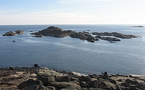
184:. Færder covers an area of 340 km (130 sq mi), of which 325 km (125 sq mi) is sea and 15 km (6 sq mi) is land. The park was established on 23 August 2013. The park includes large parts of the archipelago of
225:
364:
911:
496:
448:
524:
935:
64:
544:
854:
904:
766:
669:
960:
940:
489:
897:
733:
684:
761:
751:
955:
930:
482:
629:
771:
746:
694:
505:
847:
456:
756:
704:
792:
709:
594:
584:
579:
452:
129:
689:
787:
714:
534:
869:
840:
549:
519:
193:
426:
699:
679:
659:
634:
599:
564:
559:
181:
649:
624:
589:
554:
945:
741:
604:
529:
173:
252:
609:
157:
674:
664:
614:
574:
403:
324:
619:
189:
654:
539:
333:
644:
639:
145:
207:
216:
950:
177:
398:
279:
288:
881:
877:
824:
924:
153:
270:
812:
243:
172:, and includes some islands and coastal areas to the east of the larger islands of
315:
306:
365:"Forskrift om vern av Færder nasjonalpark, Nøtterøy og Tjøme kommuner, Vestfold"
169:
52:
342:
297:
185:
79:
66:
474:
261:
41:
820:
161:
390:
30:
165:
724:
478:
885:
828:
780:
732:
512:
135:
125:
107:
95:
58:
48:
37:
23:
180:. To the east, the national park borders to the
905:
848:
490:
429:(in Norwegian). Government.no. 23 August 2013
8:
99:340 km (130 sq mi), of which
912:
898:
855:
841:
497:
483:
475:
103:325 km (125 sq mi) is water
20:
196:with its associated protected buildings.
407:(in Norwegian). Oslo: Norsk nettleksikon
370:(in Norwegian). www.regjeringen.no. 2013
101:15 km (5.8 sq mi) is land
356:
203:
7:
866:
864:
809:
807:
36:
936:Protected areas established in 2013
14:
427:"Færder nasjonalpark er oppretta"
868:
811:
723:
341:
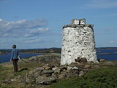
332:
323:
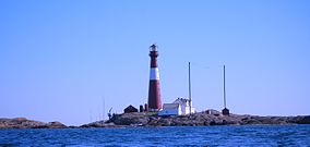
314:
305:
296:
287:
278:
269:
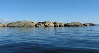
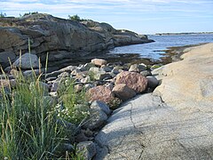
260:
251:
242:
233:
224:
215:
206:
29:
106:
47:
389:Lundbo, Sten; Askheim, Svein.
1:
961:European protected area stubs
941:2013 establishments in Norway
884:. You can help Knowledge by
827:. You can help Knowledge by
130:Norwegian Environment Agency
449:"Færder er ny nasjonalpark"
188:, as well as the protected
977:
876:This article related to a
863:
806:
721:
545:Dovrefjell–Sunndalsfjella
182:Ytre Hvaler National Park
28:
956:Vestfold geography stubs
931:National parks of Norway
506:National parks of Norway
525:Blåfjella–Skjækerfjella
194:Store Færder Lighthouse
16:National park in Norway
823:location article is a
149:
113:; 11 years ago
685:Skarvan and Roltdalen
670:Saltfjellet–Svartisen
404:Store norske leksikon
762:Nordvest-Spitsbergen
142:Færder National Park
24:Færder National Park
393:Færder nasjonalpark
158:Færder Municipality
150:Færder nasjonalpark
126:Governing body
111:23 August 2013
76: /
767:Sassen–Bünsow Land
747:Indre Wijdefjorden
459:on 21 October 2016
893:
892:
836:
835:
801:
800:
752:Nordenskiöld Land
453:Miljødirektoratet
399:Godal, Anne Marit
192:and the ruins of
190:Færder Lighthouse
168:. It is mostly a
139:
138:
49:Nearest city
968:
914:
907:
900:
872:
865:
857:
850:
843:
815:
808:
757:Nordre Isfjorden
727:
499:
492:
485:
476:
469:
468:
466:
464:
455:. Archived from
451:(in Norwegian).
445:
439:
438:
436:
434:
423:
417:
416:
414:
412:
386:
380:
379:
377:
375:
369:
361:
345:
336:
327:
318:
309:
300:
291:
282:
273:
264:
255:
246:
237:
228:
219:
210:
121:
119:
114:
91:
90:
88:
87:
86:
81:
77:
74:
73:
72:
69:
33:
21:
976:
975:
971:
970:
969:
967:
966:
965:
921:
920:
919:
918:
880:in Europe is a
862:
861:
804:
802:
797:
776:
772:Sør-Spitsbergen
728:
719:
695:Varangerhalvøya
508:
503:
473:
472:
462:
460:
447:
446:
442:
432:
430:
425:
424:
420:
410:
408:
388:
387:
383:
373:
371:
367:
363:
362:
358:
353:
346:
337:
328:
319:
310:
301:
292:
283:
274:
265:
256:
247:
238:
229:
220:
211:
202:
117:
115:
112:
102:
100:
84:
82:
80:59.12°N 10.52°E
78:
75:
70:
67:
65:
63:
62:
17:
12:
11:
5:
974:
972:
964:
963:
958:
953:
948:
943:
938:
933:
923:
922:
917:
916:
909:
902:
894:
891:
890:
878:protected area
873:
860:
859:
852:
845:
837:
834:
833:
816:
799:
798:
796:
795:
793:Ormtjernkampen
790:
784:
782:
778:
777:
775:
774:
769:
764:
759:
754:
749:
744:
738:
736:
730:
729:
722:
720:
718:
717:
712:
707:
702:
697:
692:
687:
682:
677:
672:
667:
662:
657:
652:
647:
642:
637:
632:
630:Lomsdal–Visten
627:
622:
617:
612:
607:
602:
597:
595:Jostedalsbreen
592:
587:
585:Hardangervidda
582:
580:Hallingskarvet
577:
572:
567:
562:
557:
552:
547:
542:
537:
532:
527:
522:
516:
514:
510:
509:
504:
502:
501:
494:
487:
479:
471:
470:
440:
418:
381:
355:
354:
352:
349:
348:
347:
340:
338:
331:
329:
322:
320:
313:
311:
304:
302:
295:
293:
286:
284:
277:
275:
268:
266:
259:
257:
250:
248:
241:
239:
232:
230:
223:
221:
214:
212:
205:
201:
198:
137:
136:
133:
132:
127:
123:
122:
109:
105:
104:
97:
93:
92:
60:
56:
55:
50:
46:
45:
39:
35:
34:
26:
25:
15:
13:
10:
9:
6:
4:
3:
2:
973:
962:
959:
957:
954:
952:
949:
947:
944:
942:
939:
937:
934:
932:
929:
928:
926:
915:
910:
908:
903:
901:
896:
895:
889:
887:
883:
879:
874:
871:
867:
858:
853:
851:
846:
844:
839:
838:
832:
830:
826:
822:
817:
814:
810:
805:
794:
791:
789:
786:
785:
783:
779:
773:
770:
768:
765:
763:
760:
758:
755:
753:
750:
748:
745:
743:
740:
739:
737:
735:
731:
726:
716:
713:
711:
708:
706:
703:
701:
698:
696:
693:
691:
690:Stabbursdalen
688:
686:
683:
681:
678:
676:
673:
671:
668:
666:
663:
661:
658:
656:
653:
651:
648:
646:
643:
641:
638:
636:
633:
631:
628:
626:
623:
621:
618:
616:
613:
611:
608:
606:
603:
601:
598:
596:
593:
591:
588:
586:
583:
581:
578:
576:
573:
571:
568:
566:
563:
561:
558:
556:
553:
551:
548:
546:
543:
541:
538:
536:
533:
531:
528:
526:
523:
521:
518:
517:
515:
511:
507:
500:
495:
493:
488:
486:
481:
480:
477:
458:
454:
450:
444:
441:
428:
422:
419:
406:
405:
400:
396:
394:
385:
382:
366:
360:
357:
350:
344:
339:
335:
330:
326:
321:
317:
312:
308:
303:
299:
294:
290:
285:
281:
276:
272:
267:
263:
258:
254:
249:
245:
240:
236:
231:
227:
222:
218:
213:
209:
204:
199:
197:
195:
191:
187:
183:
179:
175:
171:
167:
163:
159:
155:
154:national park
151:
147:
143:
134:
131:
128:
124:
110:
98:
94:
89:
61:
57:
54:
51:
43:
40:
32:
27:
22:
19:
886:expanding it
875:
829:expanding it
818:
803:
705:Øvre Dividal
569:
550:Femundsmarka
461:. Retrieved
457:the original
443:
431:. Retrieved
421:
409:. Retrieved
402:
392:
384:
372:. Retrieved
359:
141:
140:
85:59.12; 10.52
18:
710:Øvre Pasvik
700:Ytre Hvaler
680:Sjunkhatten
660:Rohkunborri
600:Jotunheimen
565:Fulufjellet
560:Forollhogna
170:marine park
108:Established
83: /
59:Coordinates
925:Categories
788:Gressåmoen
715:Ånderdalen
650:Reinheimen
625:Lofotodden
590:Jomfruland
555:Folgefonna
535:Børgefjell
351:References
118:2013-08-23
821:Vestfold
742:Forlandet
605:Junkerdal
530:Breheimen
520:Anárjohka
146:Norwegian
946:Nøtterøy
734:Svalbard
635:Møysalen
513:Mainland
463:19 March
433:19 March
411:19 March
374:19 March
174:Nøtterøy
164:county,
162:Vestfold
53:Tønsberg
44:, Norway
38:Location
675:Seiland
665:Rondane
615:Langsua
575:Gutulia
401:(ed.).
200:Gallery
186:Bolærne
152:) is a
116: (
71:10°31′E
68:59°07′N
781:Former
620:Lierne
570:Færder
166:Norway
42:Færder
951:Tjøme
819:This
655:Reisa
610:Láhko
540:Dovre
397:. In
368:(PDF)
178:Tjøme
882:stub
825:stub
645:Rago
640:Raet
465:2015
435:2015
413:2015
376:2015
176:and
96:Area
160:in
156:in
927::
148::
913:e
906:t
899:v
888:.
856:e
849:t
842:v
831:.
498:e
491:t
484:v
467:.
437:.
415:.
395:"
391:"
378:.
144:(
120:)
Text is available under the Creative Commons Attribution-ShareAlike License. Additional terms may apply.
↑