70:
45:
438:
324:
306:
31:
315:
77:
52:
268:
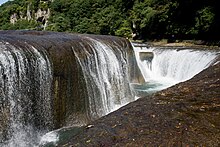
with the river flowing from three sides of the cliff. It has been called the "Oriental
Niagara" by the Numata City Tourism Board. Downstream, there are many potholes on the riverbed, with a maximum size of six to seven meters in the long axis, and there are two smaller waterfalls. There is a
69:
256:
The falls are located on the upper reaches of the
Katashina River and have a height of 7 metres (23 ft) and width of 30 metres (98 ft). The Katashina River forms a
514:
342:
272:
Due to the large volume of water at all times, water erosion on the cliff face is severe, and it currently receding at the about seven centimeters upstream in a year.
260:
between the confluence of the Hikawa River upstream and the
Kurihara River downstream. This is called the Fukiwari Ravine. The falls were created by a large-scale
123:
44:
475:
414:
494:
238:
389:
499:
234:
519:
337:
509:
468:
223:
116:
366:
461:
504:
291:
411:
423:
230:
226:
180:
173:
323:
305:
437:
261:
215:
105:
418:
393:
386:
282:
362:
445:
290:
The falls can be reached in about 30 minutes by car from the Numata
Interchange on the
488:
264:
caused by a volcanic eruption that occurred 9 million years ago, creating a cliff of
211:
101:
314:
279:
245:
30:
138:
125:
275:
The falls were used as a backdrop image for the opening credits of the 2000
269:
promenade along the river, and many souvenir shops at the entrance.
257:
219:
109:
265:
276:
449:
162:
154:
115:
97:
21:
387:Japan’s Top 100 Waterfalls Ministry of Environment
343:List of Places of Scenic Beauty of Japan (Gunma)
201:
195:
469:
8:
444:This Gunma Prefecture location article is a
237:", per a listing published by the Japanese
476:
462:
29:
18:
424:Numata city tourist information home page
515:Tourist attractions in Gunma Prefecture
354:
301:
210:is a waterfall located in the city of
76:
51:
7:
434:
432:
16:Waterfall in Gunma Prefecture, Japan
248:, it is featured on the 'ta' card.
14:
412:Tourist Guide of Gunma Prefecture
436:
322:
313:
304:
174:National Palace of Scenic Beauty
75:
68:
50:
43:
153:
1:
495:Landforms of Gunma Prefecture
448:. You can help Knowledge by
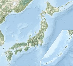
59:Show map of Gunma Prefecture
367:Agency for Cultural Affairs
239:Ministry of the Environment
202:
536:
431:
338:Japan's Top 100 Waterfalls
235:Japan’s Top 100 Waterfalls
196:
170:
93:
37:
28:
139:36.702167°N 139.207417°E
500:Places of Scenic Beauty
227:Place of Scenic Beauty
520:Gunma geography stubs
224:nationally designated
144:36.702167; 139.207417
510:Waterfalls of Japan
292:Kan'etsu Expressway
135: /
417:2020-10-24 at the
392:2020-02-19 at the
457:
456:
188:
187:
84:Show map of Japan
527:
478:
471:
464:
440:
433:
399:
398:
384:
378:
377:
375:
373:
359:
326:
317:
308:
262:pyroclastic flow
233:. It is one of "
231:Natural Monument
216:Gunma Prefecture
209:
208:
205:
203:Fukiware no taki
199:
198:
181:Natural Monument
150:
149:
147:
146:
145:
140:
136:
133:
132:
131:
128:
106:Gunma Prefecture
85:
79:
78:
72:
60:
54:
53:
47:
33:
19:
535:
534:
530:
529:
528:
526:
525:
524:
485:
484:
483:
482:
429:
419:Wayback Machine
408:
403:
402:
396:
394:Wayback Machine
385:
381:
371:
369:
361:
360:
356:
351:
334:
327:
318:
309:
300:
254:
206:
193:
184:
183:
177:
176:
143:
141:
137:
134:
129:
126:
124:
122:
121:
89:
88:
87:
86:
83:
82:
81:
80:
63:
62:
61:
58:
57:
56:
55:
23:
17:
12:
11:
5:
533:
531:
523:
522:
517:
512:
507:
502:
497:
487:
486:
481:
480:
473:
466:
458:
455:
454:
441:
427:
426:
421:
407:
406:External links
404:
401:
400:
379:
353:
352:
350:
347:
346:
345:
340:
333:
330:
329:
328:
321:
319:
312:
310:
303:
299:
296:
253:
250:
191:Fukiware Falls
186:
185:
179:
178:
172:
171:
168:
167:
164:
160:
159:
156:
152:
151:
119:
113:
112:
99:
95:
94:
91:
90:
74:
73:
67:
66:
65:
64:
49:
48:
42:
41:
40:
39:
38:
35:
34:
26:
25:
22:Fukiware Falls
15:
13:
10:
9:
6:
4:
3:
2:
532:
521:
518:
516:
513:
511:
508:
506:
505:Numata, Gunma
503:
501:
498:
496:
493:
492:
490:
479:
474:
472:
467:
465:
460:
459:
453:
451:
447:
442:
439:
435:
430:
425:
422:
420:
416:
413:
410:
409:
405:
397:(in Japanese)
395:
391:
388:
383:
380:
368:
364:
358:
355:
348:
344:
341:
339:
336:
335:
331:
325:
320:
316:
311:
307:
302:
297:
295:
293:
288:
286:
285:
281:
278:
273:
270:
267:
263:
259:
251:
249:
247:
242:
240:
236:
232:
228:
225:
221:
217:
213:
204:
192:
182:
175:
169:
165:
163:Average width
161:
157:
148:
130:139°12′26.7″E
120:
118:
114:
111:
107:
103:
100:
96:
92:
71:
46:
36:
32:
27:
20:
450:expanding it
443:
428:
382:
370:. Retrieved
363:"吹割渓ならびに吹割瀑"
357:
289:
283:
274:
271:
255:
243:
190:
189:
155:Total height
372:10 February
280:Taiga drama
246:Jomo Karuta
142: /
127:36°42′7.8″N
117:Coordinates
489:Categories
349:References
222:. It is a
241:in 1990.
166:30 meters
415:Archived
390:Archived
332:See also
252:Overview
158:7 meters
98:Location
298:Gallery
229:and a
212:Numata
102:Numata
258:gorge
220:Japan
110:Japan
446:stub
374:2020
266:tuff
197:吹割の滝
24:吹割の滝
284:Aoi
277:NHK
244:In
491::
365:.
294:.
287:.
218:,
214:,
200:,
108:,
104:,
477:e
470:t
463:v
452:.
376:.
207:)
194:(
Text is available under the Creative Commons Attribution-ShareAlike License. Additional terms may apply.