31:
484:
390:
approved
Ordinance 514 in January 1927, formally establishing the airport. The council leased the land to the chamber for five years, at a fee of $ 1 per year, and the chamber, in turn, subleased operations to William Dowling and friend Willard Morris of
358:
Freeways. The airport and its industrial park are surrounded by residential areas. It is popular among private pilots traveling within the state of
California, but there are occasional flights to and from Nevada, Arizona and Utah.
475:, Rhonda McCune. Due to the airport's location near the border of Fullerton and Buena Park, Mayor McCune alleged that "Fullerton gets all of the economic benefits from the airport while we get the accidents."
1349:
545:
1024:
1354:
419:'s Bill Barris of Fullerton Air Service, sponsored by the Fullerton Chamber of Commerce, set a world flight endurance record from the airport, keeping their modified
750:
1344:
864:
838:
581:
614:"Buena Park Mayor Wants Fullerton Airport Closed : Aviation: The second crash in two weeks renews complaints. Airport officials, pilots call it safe"
1364:
1076:
804:
167:
1278:
1205:
1017:
859:
843:
1359:
465:
552:
923:
833:
743:
1242:
1010:
968:
1071:
461:
1294:
1220:
1163:
938:
431:
326:
64:
1253:
948:
881:
736:
1112:
876:
819:
794:
386:, had petitioned the council for permission to turn the by then-abandoned sewer farm into a landing field. The Fullerton
1200:
918:
446:
160:
1248:
809:
778:
517:
382:
The airport's "official" birthday is 1927. William and Robert
Dowling, with the aid of H. A. Krause and the Fullerton
1168:
1060:
513:
1125:
1102:
799:
773:
471:
After two crashes in eight days in 1992, Fullerton
Airport faced calls for it to be closed, by the then-mayor of
438:
408:
was filmed at
Fullerton in 1929. Hughes would feature later in Fullerton's history by buying a tract of land for
341:
350:
The airport is in the southwestern corner of
Fullerton on Commonwealth Avenue, northeast of the junction of the
897:
679:
404:
1299:
1158:
963:
814:
509:
Aviation
Facilities Inc. (AFI Flight Training) is west of the control tower on the south side of the field.
416:
392:
655:
472:
150:
984:
759:
345:
116:
613:
521:
1215:
1210:
825:
457:
1033:
928:
383:
329:
106:
67:
691:
491:
Fullerton
Municipal Airport covers 86 acres (350,000 m) and has one runway and one heliport:
1304:
1190:
1120:
1107:
958:
638:
869:
412:. The campus eventually became home to Hughes Aircraft Ground Systems Group, closing in 2000.
355:
351:
318:
310:
53:
42:
1195:
1174:
1083:
953:
591:
242:
1225:
409:
1153:
913:
707:
375:
used the former pig farm as a makeshift landing strip. The site later became home to a
337:
1338:
1044:
943:
571:| publisher = FlightAware flight tracking database for KFUL | date = October 22, 2016
503:
420:
399:
124:
387:
368:
711:
30:
697:
661:
586:
483:
372:
525:
376:
120:
182:
169:
1002:
717:
701:
450:
568:
294:
728:
395:. The city would assume direct control of the facility in January 1941.
442:
253:
685:
212:
199:
721:
551:. Federal Aviation Administration. January 20, 2015. Archived from
482:
456:
The airport also had scheduled passenger air service provided by
16:
General aviation airport serving
Greater Los Angeles, California
1006:
732:
367:
Fullerton
Municipal Airport can trace its origins to 1913 when
1327:
As of 2019 previously had commercial service but now does not.
667:
582:"Endurance Flight Risk Pays; Children Get Medical Aid"
1287:
1266:
1235:
1183:
1144:
1095:
1059:
977:
906:
890:
852:
787:
766:
252:
198:
159:
148:
130:
112:
102:
94:
86:
81:
21:
498:Heliport H1: 37 × 37 ft (11 × 11 m), concrete
1350:Buildings and structures in Fullerton, California
434:funds in 1959, was the first in Orange County.
865:North Orange County Community College District
506:handles an average of 262 operations per day.
495:6/24: 3,121 × 75 ft (951 × 23 m), asphalt
1018:
839:Placentia-Yorba Linda Unified School District
744:
8:
1284:
1232:
1025:
1011:
1003:
805:Fullerton Joint Union High School District
751:
737:
729:
18:
1279:Joint Forces Training Base - Los Alamitos
569:"Lists of scheduled arrivals/departures"
1355:Transportation in Fullerton, California
537:
860:California State University, Fullerton
453:maintain helicopters on the airfield.
1345:Airports in Orange County, California
427:aloft for 1,008 hours and 2 minutes.
7:
546:"2015–2019 NPIAS Report, Appendix A"
466:de Havilland Canada DHC-6 Twin Otter
1043:Also includes some airports in the
834:Brea Olinda Unified School District
344:. It is owned and operated by the
969:Sunny Hills Performing Arts Center
14:
1365:1927 establishments in California
1072:Los Angeles International Airport
487:Fullerton Municipal Airport tower
462:Los Angeles International Airport
1295:Marine Corps Air Station El Toro
1221:United States Air Force Plant 42
512:The facility is close by to the
29:
939:Fullerton Transportation Center
706:NOAA/NWS weather observations:
432:Federal Aviation Administration
93:
949:Hunger Artists Theatre Company
882:Marshall B. Ketchum University
639:"Airport | Fullerton, CA"
430:The control tower, built with
1:
877:Hope International University
795:La Habra City School District
788:Primary and secondary schools
672:, effective September 5, 2024
1360:Airports established in 1927
919:Ralph B. Clark Regional Park
686:airport information for KFUL
675:Resources for this airport:
447:Orange County Fire Authority
1274:Fullerton Municipal Airport
1206:Hawthorne Municipal Airport
1047:in proximity to Los Angeles
934:Fullerton Municipal Airport
810:Fullerton Union High School
779:Fullerton Police Department
680:airport information for FUL
594:. April 19, 1949. p. 1
464:(LAX) which was flown with
307:Fullerton Municipal Airport
136:; 97 years ago
23:Fullerton Municipal Airport
1381:
1169:San Gabriel Valley Airport
1121:John Wayne (Orange County)
183:33.8720139°N 117.9797833°W
1317:
1137:
1052:
1041:
993:
853:Colleges and universities
800:Fullerton School District
774:Fullerton Fire Department
439:California Highway Patrol
342:Orange County, California
271:
268:
265:
261:
219:
216:
211:
207:
37:
28:
1184:Other Los Angeles County
995:This list is incomplete.
898:Fullerton Public Library
692:accident history for FUL
520:interchange, along with
415:In 1949 Dick Riedel and
188:33.8720139; -117.9797833
155:29.3 m / 96 ft
1300:Santa Ana Army Air Base
1159:Compton/Woodley Airport
964:St. Jude Medical Center
815:Sunny Hills High School
488:
1243:Grand Central Airport
985:Death of Kelly Thomas
760:Fullerton, California
486:
1322:former LAWA airports
1216:Santa Monica Airport
1211:LAPD Hooper Heliport
826:La Vista High School
767:Municipal government
468:turboprop aircraft.
460:during the 1970s to
458:Golden West Airlines
929:Fullerton Arboretum
722:Terminal Procedures
702:live flight tracker
698:airport information
662:FAA Airport Diagram
445:Police Department,
384:Chamber of Commerce
179: /
107:Greater Los Angeles
1305:Meadowlark Airport
1191:Agua Dulce Airpark
959:Muckenthaler House
718:aeronautical chart
524:in Buena Park and
522:Knott's Berry Farm
489:
1332:
1331:
1313:
1312:
1262:
1261:
1254:Lancaster Airport
1103:Hollywood Burbank
1000:
999:
870:Fullerton College
656:Fullerton Airport
618:Los Angeles Times
398:A portion of the
356:Riverside (SR 91)
346:City of Fullerton
304:
303:
300:
299:
248:
247:
134:January 1927
98:City of Fullerton
1372:
1285:
1233:
1196:Catalina Airport
1175:Whiteman Airport
1084:Van Nuys Airport
1034:Los Angeles area
1027:
1020:
1013:
1004:
954:Maverick Theater
820:Troy High School
753:
746:
739:
730:
671:
643:
642:
635:
629:
628:
626:
625:
610:
604:
603:
601:
599:
592:Associated Press
578:
572:
566:
560:
559:
557:
550:
542:
336:) is a regional
263:
262:
256:
209:
208:
202:
194:
193:
191:
190:
189:
184:
180:
177:
176:
175:
172:
144:
142:
137:
74:
73:
60:
59:
49:
48:
33:
19:
1380:
1379:
1375:
1374:
1373:
1371:
1370:
1369:
1335:
1334:
1333:
1328:
1323:
1309:
1283:
1258:
1231:
1226:Zamperini Field
1201:Crystal Airport
1179:
1146:
1140:
1133:
1091:
1062:
1055:
1048:
1037:
1031:
1001:
996:
989:
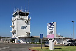
973:
902:
886:
848:
783:
762:
757:
712:past three days
665:
658:(official site)
652:
647:
646:
637:
636:
632:
623:
621:
612:
611:
607:
597:
595:
580:
579:
575:
567:
563:
555:
548:
544:
543:
539:
534:
481:
410:Hughes Aircraft
365:
352:Santa Ana (I-5)
254:
200:
187:
185:
181:
178:
173:
170:
168:
166:
165:
149:Elevation
140:
138:
135:
77:
71:
63:
57:
52:
46:
41:
24:
17:
12:
11:
5:
1378:
1376:
1368:
1367:
1362:
1357:
1352:
1347:
1337:
1336:
1330:
1329:
1318:
1315:
1314:
1311:
1310:
1308:
1307:
1302:
1297:
1291:
1289:
1282:
1281:
1276:
1270:
1268:
1264:
1263:
1260:
1259:
1257:
1256:
1251:
1249:Hughes Airport
1246:
1239:
1237:
1230:
1229:
1223:
1218:
1213:
1208:
1203:
1198:
1193:
1187:
1185:
1181:
1180:
1178:
1177:
1172:
1166:
1161:
1156:
1154:Brackett Field
1150:
1148:
1142:
1141:
1139:Minor airports
1138:
1135:
1134:
1132:
1131:
1123:
1118:
1110:
1105:
1099:
1097:
1093:
1092:
1090:
1089:
1081:
1080:
1079:
1068:
1066:
1063:World Airports
1057:
1056:
1054:Major airports
1053:
1050:
1049:
1042:
1039:
1038:
1032:
1030:
1029:
1022:
1015:
1007:
998:
997:
994:
991:
990:
988:
987:
981:
979:
975:
974:
972:
971:
966:
961:
956:
951:
946:
941:
936:
931:
926:
921:
916:
914:Burger Records
910:
908:
904:
903:
901:
900:
894:
892:
888:
887:
885:
884:
879:
874:
873:
872:
862:
856:
854:
850:
849:
847:
846:
844:Rosary Academy
841:
836:
831:
830:
829:
823:
817:
812:
802:
797:
791:
789:
785:
784:
782:
781:
776:
770:
768:
764:
763:
758:
756:
755:
748:
741:
733:
727:
726:
725:
724:
714:
704:
694:
688:
682:
673:
659:
651:
650:External links
648:
645:
644:
630:
605:
573:
561:
558:on 2016-02-22.
556:(PDF, 7.89 MB)
536:
535:
533:
530:
500:
499:
496:
480:
477:
364:
361:
338:relief airport
302:
301:
298:
297:
292:
289:
286:
282:
281:
278:
274:
273:
270:
267:
259:
258:
250:
249:
246:
245:
240:
237:
234:
230:
229:
226:
222:
221:
218:
215:
205:
204:
196:
195:
174:117°58′47.22″W
163:
157:
156:
153:
146:
145:
132:
128:
127:
114:
110:
109:
104:
100:
99:
96:
92:
91:
88:
84:
83:
79:
78:
76:
75:
61:
50:
38:
35:
34:
26:
25:
22:
15:
13:
10:
9:
6:
4:
3:
2:
1377:
1366:
1363:
1361:
1358:
1356:
1353:
1351:
1348:
1346:
1343:
1342:
1340:
1326:
1321:
1316:
1306:
1303:
1301:
1298:
1296:
1293:
1292:
1290:
1286:
1280:
1277:
1275:
1272:
1271:
1269:
1267:Orange County
1265:
1255:
1252:
1250:
1247:
1244:
1241:
1240:
1238:
1234:
1227:
1224:
1222:
1219:
1217:
1214:
1212:
1209:
1207:
1204:
1202:
1199:
1197:
1194:
1192:
1189:
1188:
1186:
1182:
1176:
1173:
1170:
1167:
1165:
1162:
1160:
1157:
1155:
1152:
1151:
1149:
1143:
1136:
1130:
1127:
1124:
1122:
1119:
1117:
1114:
1111:
1109:
1106:
1104:
1101:
1100:
1098:
1094:
1088:
1085:
1082:
1078:
1075:
1074:
1073:
1070:
1069:
1067:
1064:
1058:
1051:
1046:
1045:Inland Empire
1040:
1035:
1028:
1023:
1021:
1016:
1014:
1009:
1008:
1005:
992:
986:
983:
982:
980:
976:
970:
967:
965:
962:
960:
957:
955:
952:
950:
947:
945:
944:Goodwin Field
942:
940:
937:
935:
932:
930:
927:
925:
922:
920:
917:
915:
912:
911:
909:
905:
899:
896:
895:
893:
889:
883:
880:
878:
875:
871:
868:
867:
866:
863:
861:
858:
857:
855:
851:
845:
842:
840:
837:
835:
832:
828:(continuation
827:
824:
821:
818:
816:
813:
811:
808:
807:
806:
803:
801:
798:
796:
793:
792:
790:
786:
780:
777:
775:
772:
771:
769:
765:
761:
754:
749:
747:
742:
740:
735:
734:
731:
723:
719:
715:
713:
709:
705:
703:
699:
695:
693:
689:
687:
683:
681:
677:
676:
674:
669:
663:
660:
657:
654:
653:
649:
640:
634:
631:
619:
615:
609:
606:
593:
589:
588:
583:
577:
574:
570:
565:
562:
554:
547:
541:
538:
531:
529:
527:
523:
519:
515:
510:
507:
505:
504:control tower
497:
494:
493:
492:
485:
478:
476:
474:
469:
467:
463:
459:
454:
452:
448:
444:
440:
435:
433:
428:
426:
422:
421:Aeronca Sedan
418:
413:
411:
407:
406:
405:Hell's Angels
401:
400:Howard Hughes
396:
394:
389:
385:
380:
378:
374:
370:
362:
360:
357:
353:
348:
347:
343:
339:
335:
331:
328:
324:
320:
316:
312:
308:
296:
293:
290:
287:
284:
283:
279:
276:
275:
264:
260:
257:
251:
244:
241:
238:
235:
232:
231:
227:
224:
223:
214:
210:
206:
203:
197:
192:
171:33°52′19.25″N
164:
162:
158:
154:
152:
147:
133:
129:
126:
122:
118:
115:
111:
108:
105:
101:
97:
89:
85:
80:
69:
66:
62:
55:
51:
44:
40:
39:
36:
32:
27:
20:
1324:
1319:
1273:
1147:County Gov't
1128:
1115:
1086:
933:
696:FlightAware
633:
622:. Retrieved
620:. 1992-10-20
617:
608:
596:. Retrieved
585:
576:
564:
553:the original
540:
528:in Anaheim.
514:Interstate 5
511:
508:
501:
490:
470:
455:
436:
429:
425:Sunkist Lady
424:
414:
403:
397:
388:City Council
381:
373:crop dusters
369:barnstormers
366:
349:
333:
322:
314:
306:
305:
87:Airport type
1145:Los Angeles
1061:Los Angeles
924:Fox Theatre
587:Modesto Bee
417:Midway City
393:Yorba Linda
186: /
161:Coordinates
1339:Categories
1245:(Glendale)
1228:(Torrance)
1171:(El Monte)
1108:Long Beach
716:SkyVector
624:2020-02-02
532:References
526:Disneyland
518:Highway 91
479:Facilities
473:Buena Park
377:sewer farm
121:California
1164:Fox Field
907:Landmarks
891:Libraries
451:Mercy Air
213:Direction
117:Fullerton
1126:Palmdale
1077:Template
1036:airports
822:(magnet)
402:feature
295:Concrete
272:Surface
255:Helipads
220:Surface
113:Location
95:Operator
1113:Ontario
978:History
708:current
684:AirNav
598:May 26,
443:Anaheim
363:History
269:Length
266:Number
243:Asphalt
217:Length
201:Runways
141:1927-01
139: (
82:Summary
1288:Closed
1236:Closed
1129:(*)(X)
1096:Others
1065:(LAWA)
664:
449:, and
423:, the
239:3,121
131:Opened
103:Serves
90:Public
549:(PDF)
233:6/24
700:and
690:ASN
678:FAA
600:2012
516:and
502:Its
437:The
371:and
354:and
323:KFUL
319:ICAO
311:IATA
236:951
151:AMSL
125:U.S.
58:KFUL
54:ICAO
43:IATA
1325:(X)
1320:(*)
1116:(*)
1087:(X)
668:PDF
340:in
334:FUL
330:LID
327:FAA
315:FUL
291:37
288:11
285:H1
280:ft
228:ft
72:FUL
68:LID
65:FAA
47:FUL
1341::
720:,
710:,
616:.
590:.
584:.
441:,
379:.
332::
325:,
321::
317:,
313::
277:m
225:m
123:,
119:,
70::
56::
45::
1026:e
1019:t
1012:v
752:e
745:t
738:v
670:)
666:(
641:.
627:.
602:.
309:(
143:)
Text is available under the Creative Commons Attribution-ShareAlike License. Additional terms may apply.