65:
892:
49:
783:
622:
In the city the population was spread out, with 25.0% under the age of 18, 8.3% from 18 to 24, 31.9% from 25 to 44, 20.8% from 45 to 64, and 13.9% who were 65 years of age or older. The median age was 40 years. For every 100 females, there were 89.5 males. For every 100 females age 18 and over, there
618:
living together, 25.9% had a female householder with no husband present, and 14.8% were non-families. 14.8% of all households were made up of individuals, and 7.4% had someone living alone who was 65 years of age or older. The average household size was 2.63 and the average family size was 2.83.
603:, there were 72 people, 27 households, and 23 families residing in the city. The population density was 248.3 inhabitants per square mile (95.9/km). There were 32 housing units at an average density of 110.3 per square mile (42.6/km). The racial makeup of the city was 88.89%
64:
626:
The median income for a household in the city was $ 19,375, and the median income for a family was $ 26,250. Males had a median income of $ 58,750 versus $ 0 for females. The
815:
1011:
1001:
1016:
260:
78:
808:
270:
801:
653:
211:
708:
608:
793:
787:
48:
132:
1006:
758:
691:
Commonwealth of
Kentucky. Office of the Secretary of State. Land Office. "Fairfield, Kentucky". Accessed 25 July 2013.
361:
286:
17:
578:
563:
548:
533:
518:
503:
488:
473:
458:
443:
428:
413:
398:
298:
346:
248:
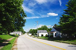
110:
677:
971:
903:
825:
290:
137:
39:
614:
There were 27 households, out of which 40.7% had children under the age of 18 living with them, 59.3% were
953:
354:
978:
948:
871:
334:
326:
221:
353:
a half-mile west of town. It lies in the upper drainage of East Fork Cox Creek, a tributary of the
931:
881:
866:
847:
604:
330:
958:
943:
921:
342:
732:
916:
704:
627:
350:
338:
314:
54:
911:
630:
for the city was $ 17,181. None of the population and none of the families were below the
995:
253:
631:
840:
678:
U.S. Geological Survey
Geographic Names Information System: Fairfield, Kentucky
120:
93:
80:
202:
782:
615:
294:
236:
125:
600:
228:
207:
364:, the city has a total area of 0.29 square miles (0.75 km).
858:
797:
890:
891:
345:(Little Union Road), Murrays Run Road and Wilkerson Road.
754:
722:
7.5 Minute
Topographic Quadrangle, USGS, 1953 (1976 rev.)
297:, in the United States. The population was 113 at the
648:
646:
930:
902:
857:
325:Fairfield is approximately five miles northwest of
269:
259:
247:
235:
218:
201:
193:
185:
180:
172:
164:
156:
148:
143:
131:
119:
109:
30:
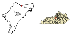
69:Location of Fairfield in Nelson County, Kentucky.
333:, and about 35 miles (56 km) southeast of
809:
8:
317:in 1818 and incorporated as a city in 1870.
816:
802:
794:
371:
27:
642:
258:
234:
200:
179:
171:
142:
108:
73:
61:
45:
673:
671:
391:
687:
685:
268:
246:
217:
192:
184:
163:
155:
147:
130:
118:
7:
1012:Populated places established in 1818
337:. Roads entering Fairfield include
895:Location of Nelson County, Kentucky
313:, Fairfield was established by the
168:0.01 sq mi (0.02 km)
160:0.29 sq mi (0.74 km)
152:0.29 sq mi (0.76 km)
824:Municipalities and communities of
733:"Census of Population and Housing"
381:
14:
1002:Cities in Nelson County, Kentucky
781:
63:
47:
1017:1818 establishments in Kentucky
701:Kentucky Atlas & Gazetteer,
25:City in Kentucky, United States
703:DeLorme, 4th ed., 2010, p. 35
1:
656:. United States Census Bureau
197:412.59/sq mi (159.46/km)
759:United States Census Bureau
654:"2020 U.S. Gazetteer Files"
362:United States Census Bureau
1033:
15:
967:
888:
838:
592:
577:
562:
547:
532:
517:
502:
487:
472:
457:
442:
427:
412:
397:
390:
385:
380:
377:
74:
62:
46:
37:
347:Kentucky State Route 509
176:735 ft (224 m)
827:Nelson County, Kentucky
896:
894:
755:"U.S. Census website"
593:U.S. Decennial Census
373:Historical population
220: • Summer (
94:37.93194°N 85.38389°W
980:United States portal
790:at Wikimedia Commons
309:Originally known as
287:home rule-class city
194: • Density
16:For other uses, see
788:Fairfield, Kentucky
374:
99:37.93194; -85.38389
90: /
32:Fairfield, Kentucky
1007:Cities in Kentucky
897:
372:
343:Kentucky Route 652
186: • Total
165: • Water
149: • Total
989:
988:
786:Media related to
628:per capita income
623:were 86.2 males.
597:
596:
360:According to the
339:Kentucky Route 48
280:
279:
157: • Land
1024:
981:
974:
893:
850:
843:
833:
828:
818:
811:
804:
795:
785:
770:
769:
767:
765:
751:
745:
744:
742:
740:
729:
723:
717:
711:
698:
692:
689:
680:
675:
666:
665:
663:
661:
650:
609:African American
393:
388:
383:
375:
225:
105:
104:
102:
101:
100:
95:
91:
88:
87:
86:
83:
67:
51:
28:
1032:
1031:
1027:
1026:
1025:
1023:
1022:
1021:
992:
991:
990:
985:
979:
973:Kentucky portal
972:
963:
935:
933:
926:
898:
886:
853:
848:
841:
834:
831:
826:
822:
778:
773:
763:
761:
753:
752:
748:
738:
736:
731:
730:
726:
718:
714:
699:
695:
690:
683:
676:
669:
659:
657:
652:
651:
644:
640:
616:married couples
599:As of the 2000
386:
370:
341:(Main Street),
329:, northeast of
323:
307:
243:
219:
98:
96:
92:
89:
84:
81:
79:
77:
76:
70:
58:
42:
33:
26:
21:
12:
11:
5:
1030:
1028:
1020:
1019:
1014:
1009:
1004:
994:
993:
987:
986:
984:
983:
976:
968:
965:
964:
962:
961:
956:
951:
946:
940:
938:
934:unincorporated
928:
927:
925:
924:
919:
914:
908:
906:
900:
899:
889:
887:
885:
884:
879:
874:
869:
863:
861:
855:
854:
839:
836:
835:
823:
821:
820:
813:
806:
798:
792:
791:
777:
776:External links
774:
772:
771:
746:
724:
720:Fairfield, KY,
712:
693:
681:
667:
641:
639:
636:
595:
594:
590:
589:
586:
584:
581:
575:
574:
571:
569:
566:
560:
559:
556:
554:
551:
545:
544:
541:
539:
536:
530:
529:
526:
524:
521:
515:
514:
511:
509:
506:
500:
499:
496:
494:
491:
485:
484:
481:
479:
476:
470:
469:
466:
464:
461:
455:
454:
451:
449:
446:
440:
439:
436:
434:
431:
425:
424:
421:
419:
416:
410:
409:
406:
404:
401:
395:
394:
389:
384:
379:
369:
366:
322:
319:
315:state assembly
306:
303:
278:
277:
274:
267:
266:
263:
257:
256:
251:
245:
244:
241:
239:
233:
232:
226:
216:
215:
205:
199:
198:
195:
191:
190:
187:
183:
182:
178:
177:
174:
170:
169:
166:
162:
161:
158:
154:
153:
150:
146:
145:
141:
140:
135:
129:
128:
123:
117:
116:
113:
107:
106:
72:
71:
68:
60:
59:
57:) in Fairfield
52:
44:
43:
38:
35:
34:
31:
24:
13:
10:
9:
6:
4:
3:
2:
1029:
1018:
1015:
1013:
1010:
1008:
1005:
1003:
1000:
999:
997:
982:
977:
975:
970:
969:
966:
960:
957:
955:
952:
950:
947:
945:
942:
941:
939:
937:
929:
923:
920:
918:
915:
913:
910:
909:
907:
905:
901:
883:
880:
878:
875:
873:
870:
868:
865:
864:
862:
860:
856:
852:
851:
844:
837:
832:United States
829:
819:
814:
812:
807:
805:
800:
799:
796:
789:
784:
780:
779:
775:
760:
756:
750:
747:
734:
728:
725:
721:
716:
713:
710:
706:
702:
697:
694:
688:
686:
682:
679:
674:
672:
668:
655:
649:
647:
643:
637:
635:
633:
629:
624:
620:
617:
612:
610:
606:
602:
591:
587:
585:
582:
580:
576:
572:
570:
567:
565:
561:
557:
555:
552:
550:
546:
542:
540:
537:
535:
531:
527:
525:
522:
520:
516:
512:
510:
507:
505:
501:
497:
495:
492:
490:
486:
482:
480:
477:
475:
471:
467:
465:
462:
460:
456:
452:
450:
447:
445:
441:
437:
435:
432:
430:
426:
422:
420:
417:
415:
411:
407:
405:
402:
400:
396:
376:
367:
365:
363:
358:
356:
352:
348:
344:
340:
336:
332:
328:
320:
318:
316:
312:
304:
302:
300:
296:
292:
291:Nelson County
288:
284:
275:
272:
264:
262:
255:
252:
250:
240:
238:
230:
227:
223:
213:
212:Eastern (EST)
209:
206:
204:
196:
188:
175:
167:
159:
151:
139:
136:
134:
127:
124:
122:
115:United States
114:
112:
103:
75:Coordinates:
66:
56:
53:Main Street (
50:
41:
36:
29:
23:
19:
876:
846:
762:. Retrieved
749:
737:. Retrieved
735:. Census.gov
727:
719:
715:
700:
696:
658:. Retrieved
632:poverty line
625:
621:
613:
598:
368:Demographics
359:
324:
310:
308:
282:
281:
22:
954:Howardstown
936:communities
842:County seat
764:January 31,
607:and 11.11%
311:Turkey Town
299:2010 census
97: /
996:Categories
949:Coxs Creek
872:Bloomfield
709:0899333400
638:References
355:Salt River
335:Louisville
327:Bloomfield
273:feature ID
181:Population
85:85°23′02″W
82:37°55′55″N
882:New Haven
877:Fairfield
867:Bardstown
849:Bardstown
660:March 18,
331:Bardstown
321:Geography
283:Fairfield
261:FIPS code
249:Area code
203:Time zone
173:Elevation
18:Fairfield
959:Nazareth
944:Balltown
922:New Hope
295:Kentucky
265:21-26020
237:ZIP code
126:Kentucky
917:Chaplin
739:June 4,
305:History
276:2403588
111:Country
912:Boston
859:Cities
707:
601:census
558:−49.3%
543:−16.0%
513:−43.8%
468:−55.0%
378:Census
349:meets
138:Nelson
133:County
932:Other
605:White
573:56.9%
498:43.6%
453:12.7%
438:41.7%
285:is a
242:40020
231:(EDT)
229:UTC-4
208:UTC-5
121:State
55:KY 48
904:CDPs
766:2008
741:2015
705:ISBN
662:2022
588:4.4%
579:2020
564:2010
549:2000
534:1990
528:3.7%
519:1980
504:1970
489:1960
474:1950
459:1930
444:1920
429:1910
414:1900
399:1870
387:Note
382:Pop.
271:GNIS
144:Area
40:City
583:118
568:113
538:142
523:169
508:163
493:290
478:202
463:148
448:329
433:292
418:206
403:167
289:in
254:502
222:DST
189:118
998::
845::
830:,
757:.
684:^
670:^
645:^
611:.
553:72
392:%±
357:.
351:48
301:.
293:,
817:e
810:t
803:v
768:.
743:.
664:.
634:.
483:—
423:—
408:—
224:)
214:)
210:(
20:.
Text is available under the Creative Commons Attribution-ShareAlike License. Additional terms may apply.