29:
46:
398:. The reservoir, completed in 1966, functions mainly to control downstream flooding on the Willamette River but is also heavily used for recreation when the lake is full. The Corps keeps water levels high—up to 161 feet (49 m)— in the lake during the spring and early summer but draws them down by up to 100 feet (30 m) below maximum in late summer through winter. This creates storage capacity for potential flood water in the rainy season. Mud flats that appear during the drawdown make recreational uses less feasible.
76:
83:
53:
413:
Winberry Creek Road runs along the
Winberry arm and meets Lowell–Unity Road (Lowell–Jasper Road) near the covered bridge. Big Fall Creek Road and Peninsula Road branch off Winberry Creek Road and, along opposite shores, follow the Fall Creek arm upstream to the end of the lake. Each road leads to one
414:
or more of the many day-use sites and campgrounds around the lake. Forest Road 18 begins at the head of the lake and follows Fall Creek upstream for many miles to other campgrounds and hiking trails in the
406:
In addition to a variety of campsites, amenities at the lake include picnic tables, boat ramps, swimming areas, toilets, and a fishing pier. Activities on the lake also include waterskiing and
678:
126:
483:
668:
378:
is of the rockfill type with a gated concrete spillway and outlet controls for regulating lake levels. The lake includes two arms, one along the Fall Creek
348:
195:
181:
45:
75:
653:
663:
28:
612:
467:
556:
391:
458:
Johnson, Daniel M.; Petersen, Richard R.; Lycan, D. Richard; Sweet, James W.; Neuhaus, Mark E., and
Schaedel, Andrew L. (1985).
374:
Fall Creek Dam, 205 feet (62 m) high, impounds up to 125,000 acre-feet (154,000,000 m) of water in the reservoir. The
673:
368:
356:
292:
500:
634:
658:
578:
188:
407:
332:
167:
108:
477:
174:
608:
463:
395:
311:
638:
375:
364:
360:
344:
296:
212:
202:
647:
415:
158:
531:
352:
427:
259:
336:
141:
128:
379:
328:
163:
390:
Fall Creek Lake is one of 13 multi-purpose water projects managed by the
430:
175:
426:
The dam and release gates were used as a filming location in the 1976
189:
435:
363:, south of Unity, are near the lake. The unincorporated community of
340:
112:
382:
and one along
Winberry Creek, a tributary entering from the south.
367:
is further downstream, below the confluence of Fall Creek with the
631:
607:(2nd ed.). Seattle: The Mountaineers Books. pp. 144–45.
462:. Corvallis: Oregon State University Press. p. 193.
526:
524:
522:
302:
288:
284:
276:
268:
258:
250:
242:
234:
226:
222:
211:
201:
187:
173:
157:
118:
104:
21:
343:. It is about 22 miles (35 km) southeast of
579:"Building Strong at Fall Creek Dam and Reservoir"
453:
451:
119:
605:Oregon State Parks: A Complete Recreation Guide
532:"Atlas of Oregon Lakes: Fall Creek Lake (Lane)"
507:. United States Geological Survey. May 22, 1986
16:Reservoir, mesotrophic in Lane County, Oregon
8:
482:: CS1 maint: multiple names: authors list (
679:United States Army Corps of Engineers dams
551:
549:
18:
632:Middle Fork Willamette Watershed Council
598:
596:
581:. United States Army Corps of Engineers
447:
355:, a covered bridge. The communities of
82:
52:
669:Protected areas of Lane County, Oregon
534:. Portland State University. 1985–2016
495:
493:
475:
254:125,000 acre-feet (154,000,000 m)
7:
505:Geographic Names Information System
33:Fall Creek Reservoir. Lane County.
14:
559:. United States Geological Survey
392:United States Corps of Engineers
81:
74:
51:
44:
27:
557:"United States Topographic Map"
275:
267:
257:
249:
241:
233:
225:
207:184 square miles (480 km)
1:
654:1966 establishments in Oregon
103:
95:Show map of the United States
664:Lakes of Lane County, Oregon
369:Middle Fork Willamette River
351:, immediately upstream from
695:
359:, at the bridge site, and
312:not a well-defined measure
309:
230:1,716 acres (694 ha)
38:
26:
567:– via Acme Mapper.
142:43.94250°N 122.75694°W
460:Atlas of Oregon Lakes
280:834 feet (254 m)
272:22 miles (35 km)
674:Reservoirs in Oregon
603:Bannan, Jan (2002).
325:Fall Creek Reservoir
246:161 feet (49 m)
147:43.94250; -122.75694
260:Residence time
238:67 feet (20 m)
138: /
637:2016-02-11 at the
422:In Popular Culture
65:Show map of Oregon
501:"Fall Creek Lake"
396:Willamette Valley
318:
317:
277:Surface elevation
686:
619:
618:
600:
591:
590:
588:
586:
575:
569:
568:
566:
564:
553:
544:
543:
541:
539:
528:
517:
516:
514:
512:
497:
488:
487:
481:
473:
455:
310:Shore length is
191:
190:Primary outflows
177:
153:
152:
150:
149:
148:
143:
139:
136:
135:
134:
131:
121:
96:
85:
84:
78:
66:
55:
54:
48:
31:
19:
694:
693:
689:
688:
687:
685:
684:
683:
644:
643:
639:Wayback Machine
628:
623:
622:
615:
602:
601:
594:
584:
582:
577:
576:
572:
562:
560:
555:
554:
547:
537:
535:
530:
529:
520:
510:
508:
499:
498:
491:
474:
470:
457:
456:
449:
444:
424:
404:
388:
323:(also known as
321:Fall Creek Lake
215: countries
176:Primary inflows
146:
144:
140:
137:
132:
129:
127:
125:
124:
100:
99:
98:
97:
94:
93:
92:
91:
90:
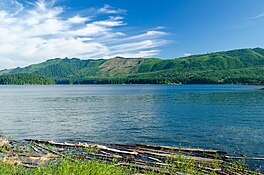
89:Fall Creek Lake
86:
69:
68:
67:
64:
63:
62:
61:
60:
59:Fall Creek Lake
56:
34:
22:Fall Creek Lake
17:
12:
11:
5:
692:
690:
682:
681:
676:
671:
666:
661:
659:Dams in Oregon
656:
646:
645:
642:
641:
627:
626:External links
624:
621:
620:
613:
592:
570:
545:
518:
489:
468:
446:
445:
443:
440:
423:
420:
403:
400:
387:
384:
376:embankment dam
316:
315:
307:
306:
304:
300:
299:
290:
286:
285:
282:
281:
278:
274:
273:
270:
266:
265:
262:
256:
255:
252:
248:
247:
244:
240:
239:
236:
232:
231:
228:
224:
223:
220:
219:
216:
209:
208:
205:
203:Catchment area
199:
198:
193:
185:
184:
179:
171:
170:
161:
155:
154:
122:
116:
115:
106:
102:
101:
88:
87:
80:
79:
73:
72:
71:
70:
58:
57:
50:
49:
43:
42:
41:
40:
39:
36:
35:
32:
24:
23:
15:
13:
10:
9:
6:
4:
3:
2:
691:
680:
677:
675:
672:
670:
667:
665:
662:
660:
657:
655:
652:
651:
649:
640:
636:
633:
630:
629:
625:
616:
614:0-89886-794-0
610:
606:
599:
597:
593:
580:
574:
571:
558:
552:
550:
546:
533:
527:
525:
523:
519:
506:
502:
496:
494:
490:
485:
479:
471:
469:0-87071-343-4
465:
461:
454:
452:
448:
441:
439:
438:
437:
432:
429:
421:
419:
417:
416:Cascade Range
411:
409:
401:
399:
397:
393:
385:
383:
381:
377:
372:
370:
366:
362:
358:
354:
350:
346:
342:
338:
334:
330:
326:
322:
313:
308:
305:
301:
298:
294:
291:
287:
283:
279:
271:
263:
261:
253:
245:
237:
235:Average depth
229:
221:
218:United States
217:
214:
210:
206:
204:
200:
197:
194:
192:
186:
183:
180:
178:
172:
169:
165:
162:
160:
156:
151:
123:
117:
114:
110:
107:
77:
47:
37:
30:
25:
20:
604:
585:February 13,
583:. Retrieved
573:
563:February 13,
561:. Retrieved
538:February 12,
536:. Retrieved
511:February 12,
509:. Retrieved
504:
459:
434:
425:
412:
405:
389:
373:
353:Unity Bridge
324:
320:
319:
269:Shore length
251:Water volume
227:Surface area
428:Irwin Allen
333:Lane County
289:Settlements
168:mesotrophic
145: /
133:122°45′25″W
120:Coordinates
109:Lane County
648:Categories
442:References
408:jet-skiing
402:Recreation
349:Fall Creek
337:U.S. state
303:References
264:3.5 months
243:Max. depth
196:Fall Creek
182:Fall Creek
130:43°56′33″N
478:cite book
380:main stem
335:, in the
329:reservoir
164:Reservoir
635:Archived
105:Location
431:TV film
394:in the
386:History
327:) is a
611:
466:
436:Flood!
365:Jasper
361:Lowell
345:Eugene
341:Oregon
297:Lowell
113:Oregon
357:Unity
293:Unity
213:Basin
609:ISBN
587:2016
565:2016
540:2016
513:2016
484:link
464:ISBN
159:Type
347:on
339:of
331:in
650::
595:^
548:^
521:^
503:.
492:^
480:}}
476:{{
450:^
433:,
418:.
410:.
371:.
295:,
166:,
111:,
617:.
589:.
542:.
515:.
486:)
472:.
314:.
Text is available under the Creative Commons Attribution-ShareAlike License. Additional terms may apply.