218:
253:
277:
265:
31:
205:
The bridge was to be privately operated until June 1, 2018, following a five-year extension of its original 25-year charter in 2013. In May 2014, The City of
Moorhead sued Bridge Co., the owners of the bridge; and the city of Fargo. Judge Frank Racek ruled in favor of the city of Moorhead and that
488:
493:
329:
45:
403:
458:
301:
468:
463:
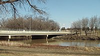
241:, the bridge is frequently flooded. The bridge is closed when the water level reaches 28', which occurred most recently in spring of 2023.
498:
473:
217:
355:
379:
483:
478:
162:
38:
333:
427:
230:
238:
191:
88:
281:
199:
195:
102:
98:
269:
222:
257:
330:"Fargo Weighs in on Toll Bridge Debate - Valley News Live - KVLY/KXJB - Fargo/Grand Forks"
252:
225:
of the 2023 spring flooding. The water level was at 29.5', just below the threshold for a
264:
452:
302:"$ 1.5 Million Grant To Study Replacing Former Toll Bridge in North Fargo/Moorhead"
30:
226:
187:
16:
Toll bridge over the Red River of the North, bridging North Dakota and
Minnesota
60:
47:
209:
Prior to the 2014 ownership transfer, the bridge had a toll of $ 0.75.
206:
the ownership of the bridge would be transferred to the two cities.
202:. It connects Moorhead's 15th Avenue N with Fargo's 12th Avenue N.
216:
134:
380:"Judge's ruling gives northside toll bridge to Fargo, Moorhead"
356:"KVRR Fox Fargo Moorhead - North Broadway Toll Bridge Closed"
428:"Bridge now closed between Fargo and north Moorhead"
80:
2 lanes of 12th Ave N/15th Ave N and pedestrian path
171:
161:
156:
148:
143:
129:
121:
116:
108:
94:
84:
76:
37:
21:
8:
489:Transportation in Cass County, North Dakota
221:The Fargo-Moorhead Toll Bridge during the
18:
494:Transportation in Clay County, Minnesota
293:
404:"The City of Fargo - Red River Levels"
7:
324:
322:
237:Due to the frequent flooding of the
14:
112:Fargo-Moorhead Former Toll Bridge
459:Former toll bridges in Minnesota
275:
263:
251:
29:
130:
1:
469:Road bridges in North Dakota
464:Toll bridges in North Dakota
515:
184:Fargo-Moorhead Toll Bridge
23:Fargo-Moorhead Toll Bridge
499:Bridges completed in 1988
474:Road bridges in Minnesota
176:
28:
282:United States portal
231:National Weather Service
270:Engineering portal
234:
192:Red River of the North
220:
61:46.88972°N 96.77444°W
258:Transport portal
484:Moorhead, Minnesota
479:Fargo, North Dakota
200:Moorhead, Minnesota
196:Fargo, North Dakota
103:Moorhead, Minnesota
99:Fargo, North Dakota
66:46.88972; -96.77444
57: /
235:
229:as defined by the
354:Alison Voorhees.
180:
179:
506:
443:
442:
440:
439:
424:
418:
417:
415:
414:
400:
394:
393:
391:
390:
376:
370:
369:
367:
366:
351:
345:
344:
342:
341:
332:. Archived from
326:
317:
316:
314:
313:
298:
280:
279:
278:
268:
267:
256:
255:
132:
72:
71:
69:
68:
67:
62:
58:
55:
54:
53:
50:
33:
19:
514:
513:
509:
508:
507:
505:
504:
503:
449:
448:
447:
446:
437:
435:
426:
425:
421:
412:
410:
402:
401:
397:
388:
386:
378:
377:
373:
364:
362:
353:
352:
348:
339:
337:
328:
327:
320:
311:
309:
306:KVRR Local News
300:
299:
295:
290:
276:
274:
262:
250:
247:
215:
117:Characteristics
101:
65:
63:
59:
56:
51:
48:
46:
44:
43:
24:
17:
12:
11:
5:
512:
510:
502:
501:
496:
491:
486:
481:
476:
471:
466:
461:
451:
450:
445:
444:
419:
395:
371:
346:
318:
292:
291:
289:
286:
285:
284:
272:
260:
246:
243:
214:
211:
178:
177:
174:
173:
169:
168:
165:
159:
158:
154:
153:
150:
146:
145:
141:
140:
137:
127:
126:
123:
119:
118:
114:
113:
110:
106:
105:
96:
92:
91:
86:
82:
81:
78:
74:
73:
41:
35:
34:
26:
25:
22:
15:
13:
10:
9:
6:
4:
3:
2:
511:
500:
497:
495:
492:
490:
487:
485:
482:
480:
477:
475:
472:
470:
467:
465:
462:
460:
457:
456:
454:
433:
429:
423:
420:
409:
405:
399:
396:
385:
381:
375:
372:
361:
357:
350:
347:
336:on 2014-02-22
335:
331:
325:
323:
319:
307:
303:
297:
294:
287:
283:
273:
271:
266:
261:
259:
254:
249:
248:
244:
242:
240:
232:
228:
224:
219:
212:
210:
207:
203:
201:
197:
193:
189:
185:
175:
170:
166:
164:
163:Daily traffic
160:
155:
151:
147:
142:
138:
136:
128:
124:
120:
115:
111:
109:Other name(s)
107:
104:
100:
97:
93:
90:
87:
83:
79:
75:
70:
42:
40:
36:
32:
27:
20:
436:. Retrieved
434:. 2023-04-19
431:
422:
411:. Retrieved
407:
398:
387:. Retrieved
383:
374:
363:. Retrieved
359:
349:
338:. Retrieved
334:the original
310:. Retrieved
308:. 2022-08-09
305:
296:
236:
208:
204:
186:is a former
183:
181:
122:Total length
408:fargond.gov
227:major flood
188:toll bridge
64: /
39:Coordinates
453:Categories
438:2023-07-16
413:2023-07-16
389:2017-07-29
365:2017-07-29
340:2014-02-07
312:2023-07-18
288:References
157:Statistics
52:96°46′28″W
49:46°53′23″N
239:Red river
89:Red River
384:Wday.com
360:Kvrr.com
245:See also
213:Flooding
194:between
172:Location
432:InForum
190:on the
144:History
85:Crosses
77:Carries
149:Opened
95:Locale
223:crest
167:8,800
135:lanes
198:and
182:The
152:1988
125:535'
133:of
131:No.
455::
430:.
406:.
382:.
358:.
321:^
304:.
441:.
416:.
392:.
368:.
343:.
315:.
233:.
139:2
Text is available under the Creative Commons Attribution-ShareAlike License. Additional terms may apply.