43:
472:
486:
541:
649:
150:
604:
164:
655:
508:
660:
567:
95:
1137:
1107:
360:
141:
714:– You must give appropriate credit, provide a link to the license, and indicate if changes were made. You may do so in any reasonable manner, but not in any way that suggests the licensor endorses you or your use.
320: ; limite du parc national : Journal officiel n°DEVL1130604D, Décret n° 2012-649 du 4 mai 2012 portant modification du décret n° 2009-449 du 22 avril 2009, voir annexe cartographique sur
551:
1365:
69:
65:
61:
57:
53:
47:
106:
78:
523:
1154:== {{int:filedesc}} == {{Location|20|15|00|S|57|35|00|E|scale:500000}} {{Information |Description= {{fr|Carte topographique et administrative en français des
621:
332:
463:
1136:
1131:
540:
619:; with no Invariant Sections, no Front-Cover Texts, and no Back-Cover Texts. A copy of the license is included in the section entitled
423:
611:
555:
1360:
1250:
950:
933:
916:
899:
882:
846:
157:
1408:
This file contains additional information, probably added from the digital camera or scanner used to create or digitize it.
810:
721:
445:) as the author and distribute the copies and derivative works under the same license(s) that the one(s) stated below. A
1038:
1004:
830:
616:
970:
866:
794:
314:
River, coast, urban area, places, transportation / Cours d'eau, côtes, extension d'agglomération et villes, transports
519:
446:
1106:
1101:
42:
784:"}},"text\/plain":{"en":{"P180":"\u00celes d'Hy\u00e8res"}}}}": -->
471:
683:
679:
675:
671:
515:
1411:
If the file has been modified from its original state, some details may not fully reflect the modified file.
1255:
1265:
1172:
720:– If you remix, transform, or build upon the material, you must distribute your contributions under the
485:
216:
348:
667:
412:
1155:
1290:
114:
204:
192:
598:
609:
Permission is granted to copy, distribute and/or modify this document under the terms of the
406:
227:
1147:
1117:
576:
163:
595:
I, the copyright holder of this work, hereby publish it under the following licenses:
507:
321:
285:
101:
238:
des données topographiques pour les srtm3: 1:372 000 (précision : 93 m) ;
402:
1395:
1385:
147:
1280:
1124:+extension des limites du parc national : ajout de l'île de Porquerolles
366:
580:
316: : données de la carte © les contributeurs d'OpenStreetMap, CC-BY-SA
336:
1240:
1235:
1350:
1340:
1315:
1245:
1230:
1200:
1190:
1251:
Utilisateur:Flappiefh/Bac à sable/Images à améliorer/Contenu visiteur
550:
into your language, using any capable SVG editor, text editor or the
776:
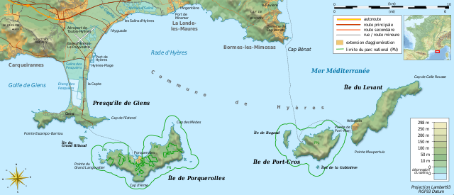
Carte topographique et administrative en français des Îles d'Hyères.
535:
1210:
1074:
Click on a date/time to view the file as it appeared at that time.
1260:
997:
442:
566:
305:
149:
1335:
317:
132:
89:
1325:
242:
of topographic data: 1:372,000 (accuracy : about 93 m);
441:
Any use of this image can be made as long as you credit me (
1270:
1256:
Wikipédia:Atelier graphique/Cartes/Archives/septembre 2011
142:
20° 15′ 00″ S, 57° 35′ 00″ E
83:(SVG file, nominally 784 × 337 pixels, file size: 1.84 MB)
1158:.}} {{de|Topographische Karte / Verwaltungskarte zum [[:
215:
Topographic and administrative map in French language of
1266:
Wikipédia:Atelier graphique/Cartes/Archives/octobre 2016
449:
with a reply address would also be greatly appreciated.
1300:
384:
378:
372:
191:
Carte topographique et administrative en français des
1375:
951:
Creative
Commons Attribution-ShareAlike 3.0 Unported
934:
615:, Version 1.2 or any later version published by the
175:
113:
Commons is a freely licensed media file repository.
917:
Creative
Commons Attribution-ShareAlike 1.0 Generic
900:
Creative
Commons Attribution-ShareAlike 2.5 Generic
883:
Creative
Commons Attribution-ShareAlike 2.0 Generic
768:
Topographic and administrative map of Îles d'Hyères
526:to clean up, improve, create or translate as well.
1305:
252: : Lambert93 ; système géodésique RGF93
1220:
333:File:France map Lambert-93 topographic-blank.svg
731:https://creativecommons.org/licenses/by-sa/3.0
262: : image of North lightning position. Le
94:
737:Creative Commons Attribution-Share Alike 3.0
648:
8:
274:is a raster image embedded in the SVG file.
203:Topographische Karte / Verwaltungskarte zum
697:– to copy, distribute and transmit the work
46:Size of this PNG preview of this SVG file:
1413:
1076:
772:
764:
749:You may select the license of your choice.
502:
430:
1183:The following other wikis use this file:
514:This map was improved or created by the
464:Template:Other versions/Îles d'Hyères map
226:Carta topografica e amministrativa delle
1431:
1423:
1415:
1170:
1052:
1036:
1018:
1002:
984:
968:
948:
931:
914:
897:
880:
864:
844:
828:
808:
792:
789:
760:
753:
467:
439:
135:
156:View this and other nearby images on:
306:NASA Shuttle Radar Topography Mission
270:embarquée dans le fichier SVG. / The
7:
627:http://www.gnu.org/copyleft/fdl.html
548:embedded text that can be translated
435:Attribution and Share-Alike required
181:Îles d'Hyères topographic map-fr.svg
1168:The following page uses this file:
1065:
659:
654:
308:(SRTM3 v.2) (domaine public) ;
1406:
781:
775:
767:
748:
645:
594:
571:
513:
443:Wikimedia Commons user: Bourrichon
220:
209:
197:
185:
126:
76:
780:
1005:coordinates of the point of view
758:
708:Under the following conditions:
666:This file is licensed under the
658:
653:
647:
603:
602:
565:
539:
506:
484:
470:
329:Locator map / Carte de situation
162:
148:
93:
31:
21:
755:
345:Other symbols / autres symboles
221:
210:
14:
754:
633:GNU Free Documentation License
622:GNU Free Documentation License
612:GNU Free Documentation License
198:
186:
26:
1:
1020:20°15'0.000"S, 57°34'59.999"E
357:Software / logiciels utilisés
36:
790:Items portrayed in this file
554:. For more information see:
538:
432:
297:Création personnelle ;
260:Shaded relief / relief ombré
1392:Usage on zh.wikivoyage.org
1366:Пор-Кро (национальный парк)
1277:Usage on fr.wiktionary.org
1217:Usage on en.wikivoyage.org
556:About translating SVG files
367:Visualization software 3DEM
1453:
1382:Usage on zh.wikipedia.org
1372:Usage on www.wikidata.org
1357:Usage on ru.wikipedia.org
1347:Usage on pt.wikipedia.org
1332:Usage on pl.wikipedia.org
1322:Usage on oc.wikipedia.org
1312:Usage on nn.wikipedia.org
1297:Usage on la.wikipedia.org
1287:Usage on ja.wikipedia.org
1236:Parc national de Port-Cros
1227:Usage on fr.wikipedia.org
1207:Usage on de.wikipedia.org
1197:Usage on da.wikipedia.org
1187:Usage on cs.wikipedia.org
722:same or compatible license
545:
1231:Conservatoire du littoral
1066:
349:File:Maps template-fr.svg
16:
1241:Presqu'île de Giens
757:
688:
670:Attribution-Share Alike
617:Free Software Foundation
462:Add-your-version :
100:This is a file from the
1153:
1123:
546:This SVG file contains
505:
457:
418:
398:
292:
284:
281:
178:
168:-20.250000; 57.583333
104:. Information from its
1211:Nationalpark Port-Cros
107:description page there
1132:13:53, 19 August 2011
1102:11:40, 23 August 2018
286:19 August 2011, 13:53
236:Échelle approximative
782:
552:SVG Translate tool
66:1,280 × 550 pixels
62:1,024 × 440 pixels
1440:
1439:
1420:Generated with Qt
1179:Global file usage
1161:
867:copyright license
774:
766:
644:
643:
579:was created with
563:
562:
561:
531:
530:
500:
499:
453:
452:
427:
424:Reusing this file
394:
390:
359:(méthode décrite
275:
253:
243:
240:Approximate scale
207:, in Französische
173:
172:
122:
121:
102:Wikimedia Commons
32:Global file usage
1444:
1414:
1144:
1114:
831:copyright status
744:
741:
738:
735:
732:
724:as the original.
668:Creative Commons
662:
661:
657:
656:
651:
650:
640:
637:
634:
631:
628:
606:
605:
599:
569:
543:
536:
510:
503:
488:
474:
431:
421:
409:
393:
355:
287:
258:
248:
234:
225:
214:
202:
190:
188:Français :
182:
176:
169:
166:
152:
151:
145:
144:
133:
118:
97:
96:
90:
84:
73:
58:640 × 275 pixels
54:320 × 138 pixels
48:784 × 337 pixels
1452:
1451:
1447:
1446:
1445:
1443:
1442:
1441:
1402:
1361:Йерские острова
1191:Hyèrské ostrovy
1177:
1162:
1150:
1142:
1120:
1112:
1068:
1067:
1064:
1063:
1062:
1061:
1060:
1059:
1058:
1057:
1055:
1045:
1044:
1043:
1041:
1030:
1029:
1028:
1027:
1026:
1025:
1024:
1023:
1021:
1011:
1010:
1009:
1007:
996:
995:
994:
993:
992:
991:
990:
989:
987:
977:
976:
975:
973:
962:
961:
960:
959:
958:
957:
956:
955:
953:
942:
941:
940:
939:
938:
936:
925:
924:
923:
922:
921:
919:
908:
907:
906:
905:
904:
902:
891:
890:
889:
888:
887:
885:
873:
872:
871:
869:
858:
857:
856:
855:
854:
853:
852:
851:
849:
837:
836:
835:
833:
822:
821:
820:
819:
818:
817:
816:
815:
813:
801:
800:
799:
797:
779:
778:
777:
770:
769:
752:
751:
750:
746:
745:
742:
739:
736:
733:
730:
729:
687:
663:
638:
635:
632:
629:
626:
597:
596:
591:
585:
584:
574:W3C-unspecified
527:
501:
494:
489:
480:
475:
407:
231:
228:Isole di Hyères
219:
208:
196:
180:
167:
140:
139:
136:Camera location
131:
124:
123:
112:
111:
110:is shown below.
86:
82:
75:
74:
51:
12:
11:
5:
1450:
1448:
1438:
1437:
1434:
1430:
1429:
1426:
1422:
1421:
1418:
1405:
1401:
1400:
1399:
1398:
1390:
1389:
1388:
1380:
1379:
1378:
1370:
1369:
1368:
1363:
1355:
1354:
1353:
1345:
1344:
1343:
1338:
1330:
1329:
1328:
1320:
1319:
1318:
1310:
1309:
1308:
1303:
1295:
1294:
1293:
1285:
1284:
1283:
1275:
1274:
1273:
1271:Golfe de Giens
1268:
1263:
1258:
1253:
1248:
1243:
1238:
1233:
1225:
1224:
1223:
1215:
1214:
1213:
1205:
1204:
1203:
1195:
1194:
1193:
1181:
1180:
1176:
1175:
1166:
1165:
1160:
1159:
1152:
1148:
1145:
1139:
1134:
1129:
1126:
1125:
1122:
1118:
1115:
1109:
1104:
1099:
1095:
1094:
1091:
1088:
1085:
1082:
1079:
1072:
1071:
1056:
1053:
1051:
1050:
1049:
1048:
1047:
1046:
1042:
1037:
1035:
1034:
1033:
1032:
1031:
1022:
1019:
1017:
1016:
1015:
1014:
1013:
1012:
1008:
1003:
1001:
1000:
999:
998:
988:
986:19 August 2011
985:
983:
982:
981:
980:
979:
978:
974:
969:
967:
966:
965:
964:
963:
954:
949:
947:
946:
945:
944:
943:
937:
932:
930:
929:
928:
927:
926:
920:
915:
913:
912:
911:
910:
909:
903:
898:
896:
895:
894:
893:
892:
886:
881:
879:
878:
877:
876:
875:
874:
870:
865:
863:
862:
861:
860:
859:
850:
845:
843:
842:
841:
840:
839:
838:
834:
829:
827:
826:
825:
824:
823:
814:
809:
807:
806:
805:
804:
803:
802:
798:
793:
791:
788:
787:
786:
785:
783:
771:
763:
762:
759:
756:
747:
728:
727:
726:
725:
715:
706:
705:
704:
698:
691:You are free:
665:
664:
646:
642:
641:
607:
593:
592:
590:
587:
564:
560:
559:
544:
529:
528:
524:propose images
511:
498:
497:
496:
495:
490:
483:
481:
476:
469:
459:
458:Other versions
455:
454:
451:
450:
438:
437:
428:
416:
415:
400:
396:
395:
392:
391:
389:
388:
382:
376:
370:
352:
351:
341:
340:
325:
324:
310:
309:
294:
290:
289:
283:
279:
278:
277:
276:
266:est une image
255:
254:
245:
244:
183:
174:
171:
170:
160:
154:
137:
130:
127:
125:
120:
119:
98:
88:
87:
45:
41:
40:
39:
34:
29:
24:
19:
13:
10:
9:
6:
4:
3:
2:
1449:
1435:
1432:
1427:
1424:
1419:
1416:
1412:
1409:
1403:
1397:
1394:
1393:
1391:
1387:
1384:
1383:
1381:
1377:
1374:
1373:
1371:
1367:
1364:
1362:
1359:
1358:
1356:
1352:
1349:
1348:
1346:
1342:
1339:
1337:
1336:Zatoka Hyères
1334:
1333:
1331:
1327:
1324:
1323:
1321:
1317:
1314:
1313:
1311:
1307:
1304:
1302:
1299:
1298:
1296:
1292:
1289:
1288:
1286:
1282:
1281:îles d’Hyères
1279:
1278:
1276:
1272:
1269:
1267:
1264:
1262:
1259:
1257:
1254:
1252:
1249:
1247:
1244:
1242:
1239:
1237:
1234:
1232:
1229:
1228:
1226:
1222:
1219:
1218:
1216:
1212:
1209:
1208:
1206:
1202:
1199:
1198:
1196:
1192:
1189:
1188:
1186:
1185:
1184:
1178:
1174:
1171:
1169:
1163:
1157:
1151:
1146:
1140:
1138:
1135:
1133:
1130:
1128:
1127:
1121:
1116:
1110:
1108:
1105:
1103:
1100:
1097:
1096:
1092:
1089:
1086:
1083:
1080:
1078:
1077:
1075:
1069:
1054:image/svg+xml
1040:
1006:
972:
952:
935:
918:
901:
884:
868:
848:
832:
812:
811:Îles d'Hyères
796:
734:CC BY-SA 3.0
723:
719:
716:
713:
710:
709:
707:
702:
699:
696:
693:
692:
690:
689:
685:
681:
677:
673:
669:
652:
624:
623:
618:
614:
613:
608:
601:
600:
588:
582:
578:
575:
568:
557:
553:
549:
542:
537:
534:
533:
525:
521:
517:
516:Wikigraphists
512:
509:
504:
493:
487:
482:
479:
473:
468:
466:
465:
460:
456:
448:
444:
440:
436:
433:
429:
425:
420:
417:
414:
413:fr:Bourrichon
410:
404:
401:
397:
386:
383:
380:
377:
374:
371:
368:
365:
364:
362:
358:
354:
353:
350:
347:provenant de
346:
343:
342:
338:
334:
330:
327:
326:
322:
319:
318:Openstreetmap
315:
312:
311:
307:
303:
300:
299:
298:
295:
291:
280:
273:
272:shaded relief
269:
265:
261:
257:
256:
251:
247:
246:
241:
237:
233:
232:
230:(en francese)
229:
224:
218:
217:Îles d'Hyères
213:
206:
205:Îles d'Hyères
201:
194:
193:Îles d'Hyères
189:
184:
177:
165:
161:
159:
158:OpenStreetMap
155:
153:
143:
138:
134:
128:
116:
109:
108:
103:
99:
92:
91:
85:
80:
79:Original file
71:
67:
63:
59:
55:
49:
44:
38:
35:
33:
30:
28:
25:
23:
20:
18:
15:
1410:
1407:
1182:
1167:
1073:
1070:File history
717:
711:
700:
694:
672:3.0 Unported
620:
610:
577:vector image
573:
547:
532:
491:
477:
461:
434:
356:
344:
328:
313:
301:
296:
271:
267:
264:relief ombré
263:
259:
249:
239:
235:
222:
211:
199:
187:
115:You can help
105:
77:
22:File history
1417:Image title
847:copyrighted
718:share alike
712:attribution
684:1.0 Generic
680:2.0 Generic
676:2.5 Generic
520:Graphic Lab
373:Quantum GIS
331:dérivée de
302:Topographie
179:Description
1301:Stoechades
1164:File usage
1149:Bourrichon
1141:784 × 337
1119:Bourrichon
1111:784 × 337
1087:Dimensions
1039:media type
419:Permission
403:Bourrichon
337:User:Sting
250:Projection
223:Italiano:
27:File usage
1436:337.08383
1428:783.98285
1143:(1.83 MB)
1113:(1.84 MB)
1084:Thumbnail
1081:Date/Time
971:inception
589:Licensing
492:jpg blank
363:) :
212:English:
200:Deutsch:
1404:Metadata
1376:Q9387401
761:Captions
701:to remix
695:to share
686:license.
581:Inkscape
385:Inkscape
379:The Gimp
304: :
37:Metadata
1098:current
1093:Comment
795:depicts
765:English
518:of the
447:message
387: ;
381: ;
375: ;
369: ;
339: ;
129:Summary
81:
1433:Height
1291:イエール諸島
773:French
570:
478:svg fr
399:Author
293:Source
268:bitmap
146:
1425:Width
1306:Areae
572:This
288:(UTC)
1396:耶爾群島
1386:耶尔群岛
1090:User
743:true
740:true
682:and
639:true
636:true
630:GFDL
411:) -
408:talk
282:Date
17:File
1221:Var
335:by
678:,
674:,
558:.
68:|
64:|
60:|
56:|
50:.
625:.
583:.
426:)
422:(
405:(
323:.
195:.
117:.
72:.
Text is available under the Creative Commons Attribution-ShareAlike License. Additional terms may apply.
