43:
195:
343:
277:
357:
201:
957:
99:
65:
61:
57:
53:
47:
334:
974:== {{int:filedesc}} == {{Information |description=稻城白塔 - White Pagoda in Daocheng County - 2012.10 |date={{Taken on|2012-10-21}} |source=http://www.panoramio.com/photo/83299827 |author=[http://www.panoramio.com/user/5226993?with_photo_id=832998...
110:
78:
1026:
248:– You must give appropriate credit, provide a link to the license, and indicate if changes were made. You may do so in any reasonable manner, but not in any way that suggests the licensor endorses you or your use.
956:
951:
69:
42:
477:
173:
184:
655:
620:
550:
514:
350:
1208:
1039:
This file contains additional information, probably added from the digital camera or scanner used to create or digitize it.
1016:
1006:
868:
640:
449:
888:
818:
781:
747:
710:
676:
604:
498:
470:
457:
442:
648:
633:
570:
534:
415:
398:
163:
852:
967:
1042:
If the file has been modified from its original state, some details may not fully reflect the modified file.
1248:
211:
478:
https://web.archive.org/web/20161025091202/http://www.panoramio.com/user/5226993?with_photo_id=83299827
292:
208:
1284:
1059:
1177:
118:
1373:
988:
296:, who confirmed that it was available on Panoramio under the above license on that date.
356:
1336:
1266:
1076:
105:
1383:
1346:
1116:
656:
https://web.archive.org/web/20161025091200/http://www.panoramio.com/photo/83299827
340:
164:
https://web.archive.org/web/20161025091200/http://www.panoramio.com/photo/83299827
1302:
285:
1096:
1393:
1086:
924:
Click on a date/time to view the file as it appeared at that time.
1069:
669:
335:
29° 03′ 02.87″ N, 100° 17′ 51.26″ E
342:
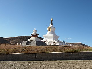
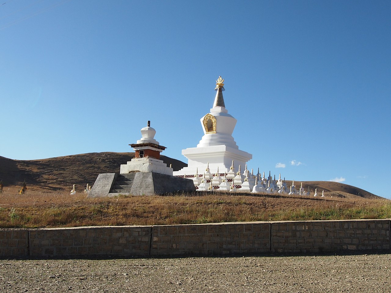
143:稻城白塔 - White Pagoda in Daocheng County - 2012.10 - panoramio.jpg
325:
271:
93:
382:
Add a one-line explanation of what this file represents
83:(2,552 × 1,913 pixels, file size: 1.09 MB, MIME type:
137:
117:
Commons is a freely licensed media file repository.
290:, was automatically reviewed on 8 February 2017 by
147:稻城白塔 - White Pagoda in Daocheng County - 2012.10
98:
194:
8:
1289:Flash did not fire, compulsory flash firing
282:This image, which was originally posted to
255:https://creativecommons.org/licenses/by/3.0
231:– to copy, distribute and transmit the work
1044:
926:
378:
999:The following other wikis use this file:
551:Creative Commons Attribution 3.0 Unported
1425:
1417:
1409:
1401:
1391:
1381:
1371:
1363:
1355:
1344:
1334:
1326:
1318:
1310:
1300:
1292:
1282:
1274:
1264:
1256:
1246:
1225:
1217:
1206:
1198:
1190:
1182:
1172:
1164:
1156:
1148:
1140:
1132:
1124:
1113:
1105:
1094:
1084:
1074:
1064:
1046:
986:
902:
886:
866:
850:
832:
816:
795:
779:
761:
745:
724:
708:
690:
674:
618:
602:
584:
568:
548:
532:
512:
496:
429:
413:
396:
393:
374:
367:
328:
349:View this and other nearby images on:
1054:
7:
984:The following page uses this file:
915:
284:
200:
1037:
387:
381:
222:
191:
130:
76:
1027:Гардзе-Тибетский автономный округ
386:
261:Creative Commons Attribution 3.0
1145:3,759.194 meters above sea level
1107:Date and time of data generation
677:coordinates of the point of view
372:
355:
341:
275:
242:Under the following conditions:
207:This file is licensed under the
199:
193:
97:
31:
21:
1178:Version 1.3
1051:OLYMPUS DIGITAL CAMERA
369:
14:
621:file available on the internet
368:
26:
1:
692:29°3'2.869"N, 100°17'51.259"E
155:Taken on 21 October 2012
36:
443:object of statement has role
394:Items portrayed in this file
1219:Date and time of digitizing
307:(from Panoramio photo page)
1447:
1294:Supported Flashpix version
1023:Usage on ru.wikipedia.org
1013:Usage on fa.wikipedia.org
1003:Usage on ar.wikipedia.org
1411:Geodetic survey data used
1227:Meaning of each component
1184:File change date and time
916:
16:
371:
212:Attribution 3.0 Unported
104:This is a file from the
1403:GPS time (atomic clock)
1320:Custom image processing
1261:3.61328125 APEX (f/3.5)
973:
179:
169:
159:
154:
151:
140:
108:. Information from its
1222:16:50, 21 October 2012
1187:16:50, 21 October 2012
1110:16:50, 21 October 2012
952:00:59, 8 February 2017
361:29.050797; 100.297572
318:甘孜州 - Garze Prefecture
111:description page there
46:Size of this preview:
1258:Maximum land aperture
1158:Horizontal resolution
1060:OLYMPUS IMAGING CORP.
1341:Manual white balance
1315:Digital still camera
1081:1/320 sec (0.003125)
969:Panoramio upload bot
293:Panoramio upload bot
70:2,552 × 1,913 pixels
1192:Y and C positioning
1166:Vertical resolution
1056:Camera manufacturer
237:– to adapt the work
52:Other resolutions:
1357:Scene capture type
458:author name string
66:1,280 × 959 pixels
62:1,024 × 768 pixels
1434:
1433:
1203:Aperture priority
1137:100° 17′ 51.26″ E
995:Global file usage
977:
535:copyright license
380:
366:
365:
323:
322:
300:
299:
188:
185:Reusing this file
126:
125:
106:Wikimedia Commons
32:Global file usage
1438:
1200:Exposure Program
1070:E-PL3
1045:
964:
800:
729:
658:
653:
649:described at URL
643:
638:
499:copyright status
480:
475:
465:
462:
452:
447:
362:
359:
345:
344:
338:
337:
326:
319:
315:
288:
279:
278:
272:
268:
265:
262:
259:
256:
220:
209:Creative Commons
203:
202:
197:
196:
182:
144:
138:
122:
101:
100:
94:
88:
86:
73:
58:640 × 480 pixels
54:320 × 240 pixels
48:800 × 600 pixels
1446:
1445:
1441:
1440:
1439:
1437:
1436:
1435:
1427:GPS tag version
1422:21 October 2012
1331:Manual exposure
1033:
993:
989:Daocheng County
978:
970:
962:
918:
917:
914:
913:
912:
911:
910:
909:
908:
907:
905:
895:
894:
893:
891:
880:
879:
878:
877:
876:
875:
874:
873:
871:
859:
858:
857:
855:
844:
843:
842:
841:
840:
839:
838:
837:
835:
825:
824:
823:
821:
810:
809:
808:
807:
806:
805:
804:
803:
801:
798:
788:
787:
786:
784:
773:
772:
771:
770:
769:
768:
767:
766:
764:
754:
753:
752:
750:
739:
738:
737:
736:
735:
734:
733:
732:
730:
727:
717:
716:
715:
713:
702:
701:
700:
699:
698:
697:
696:
695:
693:
683:
682:
681:
679:
668:
667:
666:
665:
664:
663:
662:
661:
660:
659:
654:
651:
645:
644:
639:
636:
627:
626:
625:
623:
611:
610:
609:
607:
596:
595:
594:
593:
592:
591:
590:
589:
587:
586:21 October 2012
577:
576:
575:
573:
562:
561:
560:
559:
558:
557:
556:
555:
553:
541:
540:
539:
537:
526:
525:
524:
523:
522:
521:
520:
519:
517:
505:
504:
503:
501:
490:
489:
488:
487:
486:
485:
484:
483:
482:
481:
476:
473:
467:
466:
463:
460:
454:
453:
448:
445:
436:
435:
434:
432:
422:
421:
420:
418:
407:
406:
405:
404:
403:
401:
385:
384:
383:
360:
333:
332:
329:Camera location
324:
317:
313:
310:
276:
270:
269:
266:
263:
260:
257:
254:
253:
221:
218:
215:
204:
142:
135:
128:
127:
116:
115:
114:is shown below.
90:
84:
82:
75:
74:
51:
12:
11:
5:
1444:
1442:
1432:
1431:
1428:
1424:
1423:
1420:
1416:
1415:
1412:
1408:
1407:
1404:
1400:
1399:
1396:
1390:
1389:
1386:
1380:
1379:
1376:
1370:
1369:
1366:
1362:
1361:
1358:
1354:
1353:
1350:
1343:
1342:
1339:
1333:
1332:
1329:
1325:
1324:
1323:Normal process
1321:
1317:
1316:
1313:
1309:
1308:
1305:
1299:
1298:
1295:
1291:
1290:
1287:
1281:
1280:
1277:
1273:
1272:
1269:
1263:
1262:
1259:
1255:
1254:
1251:
1245:
1244:
1243:
1242:
1241:does not exist
1239:
1236:
1233:
1228:
1224:
1223:
1220:
1216:
1215:
1212:
1205:
1204:
1201:
1197:
1196:
1193:
1189:
1188:
1185:
1181:
1180:
1175:
1171:
1170:
1167:
1163:
1162:
1159:
1155:
1154:
1151:
1147:
1146:
1143:
1139:
1138:
1135:
1131:
1130:
1129:29° 3′ 2.87″ N
1127:
1123:
1122:
1119:
1112:
1111:
1108:
1104:
1103:
1100:
1093:
1092:
1089:
1083:
1082:
1079:
1073:
1072:
1067:
1063:
1062:
1057:
1053:
1052:
1049:
1036:
1032:
1031:
1030:
1029:
1021:
1020:
1019:
1017:شهرستان داوچنگ
1011:
1010:
1009:
1007:مقاطعة داوجينغ
997:
996:
992:
991:
982:
981:
976:
975:
972:
968:
965:
961:2,552 × 1,913
959:
954:
949:
945:
944:
941:
938:
935:
932:
929:
922:
921:
906:
903:
901:
900:
899:
898:
897:
896:
892:
887:
885:
884:
883:
882:
881:
872:
867:
865:
864:
863:
862:
861:
860:
856:
851:
849:
848:
847:
846:
845:
836:
833:
831:
830:
829:
828:
827:
826:
822:
817:
815:
814:
813:
812:
811:
802:
796:
794:
793:
792:
791:
790:
789:
785:
780:
778:
777:
776:
775:
774:
765:
762:
760:
759:
758:
757:
756:
755:
751:
746:
744:
743:
742:
741:
740:
731:
725:
723:
722:
721:
720:
719:
718:
714:
709:
707:
706:
705:
704:
703:
694:
691:
689:
688:
687:
686:
685:
684:
680:
675:
673:
672:
671:
670:
647:
646:
632:
631:
630:
629:
628:
624:
619:
617:
616:
615:
614:
613:
612:
608:
605:source of file
603:
601:
600:
599:
598:
597:
588:
585:
583:
582:
581:
580:
579:
578:
574:
569:
567:
566:
565:
564:
563:
554:
549:
547:
546:
545:
544:
543:
542:
538:
533:
531:
530:
529:
528:
527:
518:
513:
511:
510:
509:
508:
507:
506:
502:
497:
495:
494:
493:
492:
491:
469:
468:
456:
455:
441:
440:
439:
438:
437:
433:
430:
428:
427:
426:
425:
424:
423:
419:
414:
412:
411:
410:
409:
408:
402:
397:
395:
392:
391:
390:
389:
388:
377:
376:
373:
370:
364:
363:
353:
347:
330:
321:
320:
311:
308:
302:
301:
298:
297:
280:
252:
251:
250:
249:
240:
239:
238:
232:
225:You are free:
216:
206:
205:
192:
189:
177:
176:
171:
167:
166:
161:
157:
156:
153:
149:
148:
145:
136:
134:
131:
129:
124:
123:
102:
92:
91:
45:
41:
40:
39:
34:
29:
24:
19:
13:
10:
9:
6:
4:
3:
2:
1443:
1429:
1426:
1421:
1418:
1413:
1410:
1405:
1402:
1397:
1395:
1392:
1387:
1385:
1382:
1377:
1375:
1372:
1367:
1365:Scene control
1364:
1359:
1356:
1351:
1348:
1345:
1340:
1338:
1337:White balance
1335:
1330:
1328:Exposure mode
1327:
1322:
1319:
1314:
1311:
1306:
1304:
1301:
1296:
1293:
1288:
1286:
1283:
1278:
1275:
1270:
1268:
1267:Metering mode
1265:
1260:
1257:
1252:
1250:
1249:Exposure bias
1247:
1240:
1237:
1234:
1231:
1230:
1229:
1226:
1221:
1218:
1213:
1210:
1207:
1202:
1199:
1194:
1191:
1186:
1183:
1179:
1176:
1174:Software used
1173:
1168:
1165:
1160:
1157:
1152:
1149:
1144:
1141:
1136:
1133:
1128:
1125:
1120:
1118:
1114:
1109:
1106:
1101:
1098:
1095:
1090:
1088:
1085:
1080:
1078:
1077:Exposure time
1075:
1071:
1068:
1065:
1061:
1058:
1055:
1050:
1047:
1043:
1040:
1034:
1028:
1025:
1024:
1022:
1018:
1015:
1014:
1012:
1008:
1005:
1004:
1002:
1001:
1000:
994:
990:
987:
985:
979:
971:
966:
960:
958:
955:
953:
950:
947:
946:
942:
939:
936:
933:
930:
928:
927:
925:
919:
890:
870:
854:
820:
783:
749:
712:
711:exposure time
678:
657:
650:
642:
635:
622:
606:
572:
552:
536:
516:
500:
479:
472:
459:
451:
444:
417:
400:
358:
354:
352:
351:OpenStreetMap
348:
346:
336:
331:
327:
312:
306:
304:
303:
295:
294:
289:
287:
281:
274:
273:
247:
244:
243:
241:
236:
233:
230:
227:
226:
224:
223:
217:Attribution:
213:
210:
198:
190:
186:
181:
178:
175:
172:
168:
165:
162:
158:
150:
146:
139:
132:
120:
113:
112:
107:
103:
96:
95:
89:
80:
79:Original file
71:
67:
63:
59:
55:
49:
44:
38:
35:
33:
30:
28:
25:
23:
20:
18:
15:
1347:Digital zoom
1276:Light source
1117:focal length
1066:Camera model
1041:
1038:
998:
983:
923:
920:File history
782:focal length
450:photographer
291:
283:
245:
234:
228:
119:You can help
109:
77:
22:File history
1312:File source
1303:Color space
1150:Orientation
1048:Image title
853:instance of
515:copyrighted
246:attribution
141:Description
1384:Saturation
980:File usage
937:Dimensions
904:image/jpeg
889:media type
869:photograph
799:millimetre
431:some value
258:CC BY 3.0
180:Permission
85:image/jpeg
27:File usage
1394:Sharpness
1134:Longitude
1097:ISO speed
963:(1.09 MB)
934:Thumbnail
931:Date/Time
819:ISO speed
726:0.003125
641:Panoramio
571:inception
309:InfoField
286:Panoramio
1419:GPS date
1374:Contrast
1360:Standard
1195:Co-sited
1142:Altitude
1126:Latitude
1087:F-number
1035:Metadata
748:f-number
634:operator
375:Captions
235:to remix
229:to share
214:license.
37:Metadata
1430:0.0.0.2
1279:Unknown
1271:Pattern
1211:version
1169:314 dpi
1161:314 dpi
948:current
943:Comment
416:creator
399:depicts
379:English
133:Summary
81:
1414:WGS-84
1398:Normal
1388:Normal
1378:Normal
1153:Normal
1099:rating
728:second
464:rheins
339:
219:rheins
174:rheins
170:Author
160:Source
1406:08:50
1349:ratio
1285:Flash
1121:16 mm
1115:Lens
314:Garze
1368:None
1307:sRGB
1214:2.21
1209:Exif
940:User
305:Tags
267:true
264:true
152:Date
17:File
1253:0.3
1102:200
1091:f/8
834:200
797:16
471:URL
1238:Cr
1235:Cb
652::
637::
474::
461::
446::
316:,
68:|
64:|
60:|
56:|
50:.
1352:1
1297:1
1232:Y
763:8
187:)
183:(
121:.
87:)
72:.
Text is available under the Creative Commons Attribution-ShareAlike License. Additional terms may apply.
