301:
234:
184:
226:
176:
1098:
248:
198:
269:
307:
312:
67:
38:
796:"}},"text\/plain":{"en":{"":"heading"}}},"{\"value\":{\"amount\":\"+247\",\"unit\":\"http:\\\/\\\/www.wikidata.org\\\/entity\\\/Q28390\"},\"type\":\"quantity\"}":{"text\/html":{"en":{"P7787":"247
611:"}},"text\/plain":{"en":{"":"heading"}}},"{\"value\":{\"amount\":\"+247\",\"unit\":\"http:\\\/\\\/www.wikidata.org\\\/entity\\\/Q28390\"},\"type\":\"quantity\"}":{"text\/html":{"en":{"P7787":"247
217:
167:
1282:
792:
46:
121:
2012 Olympic Park viewed over
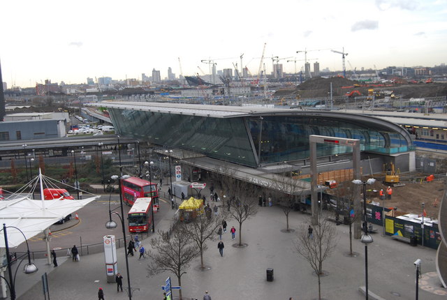
Stratford Station from the roof of The Stratford Centre Stratford is a major transport hub in East London. Several overground lines including the cross London line to Richmond pass through here, as well as the Jubilee underground line & DLR. There is also a Channel
1277:
1115:== {{int:filedesc}} == {{Information |description={{en|1=2012 Olympic Park viewed over Stratford Station from the roof of The Stratford Centre Stratford is a major transport hub in East London. Several overground lines including the cross London line to R
359:– You must give appropriate credit, provide a link to the license, and indicate if changes were made. You may do so in any reasonable manner, but not in any way that suggests the licensor endorses you or your use.
1244:
1144:
1139:
1134:
1097:
1092:
37:
1229:
1174:
1219:
1129:
793:
608:
1357:
1214:
1259:
1254:
931:
728:
594:
558:
241:
191:
1249:
1199:
1164:
763:
1179:
1149:
276:
439:
366:
1239:
506:
1204:
1189:
1026:
989:
952:
897:
863:
834:
807:
741:
712:
649:
622:
542:
514:
499:
486:
1209:
924:
771:
756:
678:
578:
459:
423:
1362:
111:
2012 Olympic Park viewed over
Stratford Station from the roof of The Stratford Centre - geograph.org.uk - 1128399.jpg
47:
2012_Olympic_Park_viewed_over_Stratford_Station_from_the_roof_of_The_Stratford_Centre_-_geograph.org.uk_-_1128399.jpg
263:
322:
1307:
1184:
1125:
The following pages on the
English Knowledge (XXG) use this file (pages on other projects are not listed):
1292:
1302:
1234:
365:– If you remix, transform, or build upon the material, you must distribute your contributions under the
283:
on the
Geograph website for the photographer's contact details. The copyright on this image is owned by
1108:
1159:
319:
800:"}},"text\/plain":{"en":{"P7787":"247 degree"}}}}": -->
615:"}},"text\/plain":{"en":{"P7787":"247 degree"}}}}": -->
1352:
1342:
1224:
1169:
1154:
122:
tunnel link & a bus station outside. This view will change dramatically over the next 3 years.
86:
1337:
1194:
778:
748:
521:
1327:
247:
197:
288:
73:
1322:
1317:
231:
181:
140:
150:
268:
1245:
Knowledge (XXG):WikiProject London
Transport/The Metropolitan/Issue 44
280:
1065:
Click on a date/time to view the file as it appeared at that time.
233:
183:
208:
158:
61:
1145:
List of busiest railway stations in Great
Britain (2021–22)
1140:
List of busiest railway stations in Great
Britain (2020–21)
1135:
List of busiest railway stations in Great
Britain (2019–20)
218:
51° 32′ 28″ N, 0° 00′ 10″ W
168:
51° 32′ 30″ N, 0° 00′ 03″ W
407:
Add a one-line explanation of what this file represents
1230:
User talk:Simply south/April to
December 2012 archive
105:
85:
Commons is a freely licensed media file repository.
1175:
User talk:DisillusionedBitterAndKnackered/Archive 2
595:
Creative
Commons Attribution-ShareAlike 2.0 Generic
1220:User talk:NEWSLETTERS MAILBOX/Archives/2012/August
1130:List of busiest railway stations in Great Britain
51:(640 × 430 pixels, file size: 69 KB, MIME type:
376:https://creativecommons.org/licenses/by-sa/2.0
66:
1293:Nagy-Britannia legforgalmasabb vasútállomásai
382:Creative Commons Attribution-Share Alike 2.0
300:
8:
797:
612:
342:– to copy, distribute and transmit the work
1067:
403:
1270:The following other wikis use this file:
1215:User talk:Matthewedwards/Archives/2012/08
779:https://www.geograph.org.uk/photo/1128399
913:bef8d4de4b855c2e6ae982c774bfdd1a9dac322f
522:https://www.geograph.org.uk/profile/3101
1328:Template:Infobox London station/sandbox
1260:Template:Infobox London station/sandbox
1127:
1040:
1024:
1003:
987:
966:
950:
911:
895:
877:
861:
821:
805:
726:
710:
692:
676:
636:
620:
592:
576:
556:
540:
473:
457:
437:
421:
418:
399:
392:
211:
161:
240:View this and other nearby images on:
190:View this and other nearby images on:
7:
287:and is licensed for reuse under the
1323:Template:Infobox London station/doc
1255:Template:Infobox London station/doc
1056:
323:Attribution-Share Alike 2.0 Generic
311:
306:
291:Attribution-ShareAlike 2.0 license.
1283:টেমপ্লেট:তথ্যছক লন্ডনের স্টেশন/নথি
412:
406:
297:
274:
115:
98:
44:
411:
623:coordinates of the point of view
397:
353:Under the following conditions:
318:This file is licensed under the
310:
305:
299:
267:
246:
232:
224:
196:
182:
174:
65:
31:
21:
1318:Template:Infobox London station
1308:ഫലകം:Infobox London station/doc
1250:Template:Infobox London station
1200:User talk:Iridescent/Archive 16
1165:User talk:CrossHouses/Archive 1
394:
116:
41:No higher resolution available.
14:
1343:మూస:Infobox London station/doc
1314:Usage on simple.wikipedia.org
1278:টেমপ্লেট:তথ্যছক লন্ডনের স্টেশন
1180:User talk:Fungbregas/Archive 2
1150:User talk:Alarics/Archive 2012
729:file available on the internet
393:
275:This image was taken from the
26:
1:
1240:User talk:Thryduulf/archive10
808:coordinates of depicted place
131:Taken on 20 January 2009
1205:User talk:Likelife/Archive 2
1190:User talk:Huangcjz/Archive 1
764:Geograph Britain and Ireland
500:object of statement has role
419:Items portrayed in this file
223:
173:
1303:ഫലകം:Infobox London station
1210:User talk:Malpass93/Archive
1381:
1349:Usage on zh.wikipedia.org
1338:మూస:Infobox London station
1334:Usage on te.wikipedia.org
1299:Usage on ml.wikipedia.org
1289:Usage on hu.wikipedia.org
1274:Usage on bn.wikipedia.org
823:51°32'27.56"N, 0°0'10.44"W
367:same or compatible license
1057:
638:51°32'29.72"N, 0°0'2.52"W
440:Stratford railway station
16:
742:geograph.org.uk image ID
396:
333:
72:This is a file from the
1185:User talk:Geordiewomble
1114:
1093:23:43, 24 February 2011
146:
135:
130:
127:
108:
76:. Information from its
281:this photograph's page
252:51.540990; -0.002900
202:51.541590; -0.000700
79:description page there
1235:User talk:Sunil060902
1160:User talk:BigToe7000
925:determination method
1225:User talk:OllieFury
1170:User talk:Dennisman
1155:User talk:Arriva436
348:– to adapt the work
487:author name string
1266:Global file usage
1118:
799:
614:
579:copyright license
405:
296:
295:
279:collection. See
257:
256:
207:
206:
156:
155:
94:
93:
74:Wikimedia Commons
32:Global file usage
1372:
1195:User talk:Hyper3
1105:
1045:
1008:
971:
934:
929:
845:
844:
839:
781:
776:
772:described at URL
766:
761:
751:
746:
660:
659:
654:
543:copyright status
524:
519:
509:
504:
494:
491:
389:
386:
383:
380:
377:
369:as the original.
331:
320:Creative Commons
314:
313:
309:
308:
303:
302:
289:Creative Commons
277:Geograph project
271:
264:
253:
250:
236:
235:
229:
228:
227:
221:
220:
209:
203:
200:
186:
185:
179:
178:
177:
171:
170:
159:
120:
112:
106:
90:
69:
68:
62:
56:
54:
1380:
1379:
1375:
1374:
1373:
1371:
1370:
1369:
1264:
1126:
1119:
1111:
1103:
1059:
1058:
1055:
1054:
1053:
1052:
1051:
1050:
1049:
1048:
1046:
1043:
1033:
1032:
1031:
1029:
1018:
1017:
1016:
1015:
1014:
1013:
1012:
1011:
1009:
1006:
996:
995:
994:
992:
981:
980:
979:
978:
977:
976:
975:
974:
972:
969:
959:
958:
957:
955:
944:
943:
942:
941:
940:
939:
938:
937:
936:
935:
930:
927:
918:
917:
916:
914:
904:
903:
902:
900:
889:
888:
887:
886:
885:
884:
883:
882:
880:
870:
869:
868:
866:
855:
854:
853:
852:
851:
850:
849:
848:
847:
846:
842:
840:
837:
828:
827:
826:
824:
814:
813:
812:
810:
791:
790:
789:
788:
787:
786:
785:
784:
783:
782:
777:
774:
768:
767:
762:
759:
753:
752:
747:
744:
735:
734:
733:
731:
719:
718:
717:
715:
704:
703:
702:
701:
700:
699:
698:
697:
695:
694:20 January 2009
685:
684:
683:
681:
670:
669:
668:
667:
666:
665:
664:
663:
662:
661:
657:
655:
652:
643:
642:
641:
639:
629:
628:
627:
625:
606:
605:
604:
603:
602:
601:
600:
599:
597:
585:
584:
583:
581:
570:
569:
568:
567:
566:
565:
564:
563:
561:
549:
548:
547:
545:
534:
533:
532:
531:
530:
529:
528:
527:
526:
525:
520:
517:
511:
510:
505:
502:
496:
495:
492:
489:
480:
479:
478:
476:
466:
465:
464:
462:
451:
450:
449:
448:
447:
446:
445:
444:
442:
430:
429:
428:
426:
410:
409:
408:
391:
390:
387:
384:
381:
378:
375:
374:
332:
329:
326:
315:
292:
262:
251:
225:
216:
215:
212:Object location
201:
175:
166:
165:
162:Camera location
157:
141:geograph.org.uk
123:
110:
103:
96:
95:
84:
83:
82:is shown below.
58:
52:
50:
43:
42:
12:
11:
5:
1378:
1376:
1368:
1367:
1366:
1365:
1360:
1355:
1347:
1346:
1345:
1340:
1332:
1331:
1330:
1325:
1320:
1312:
1311:
1310:
1305:
1297:
1296:
1295:
1287:
1286:
1285:
1280:
1268:
1267:
1263:
1262:
1257:
1252:
1247:
1242:
1237:
1232:
1227:
1222:
1217:
1212:
1207:
1202:
1197:
1192:
1187:
1182:
1177:
1172:
1167:
1162:
1157:
1152:
1147:
1142:
1137:
1132:
1124:
1123:
1122:
1117:
1116:
1113:
1109:
1106:
1100:
1095:
1090:
1086:
1085:
1082:
1079:
1076:
1073:
1070:
1063:
1062:
1047:
1041:
1039:
1038:
1037:
1036:
1035:
1034:
1030:
1025:
1023:
1022:
1021:
1020:
1019:
1010:
1004:
1002:
1001:
1000:
999:
998:
997:
993:
988:
986:
985:
984:
983:
982:
973:
967:
965:
964:
963:
962:
961:
960:
956:
951:
949:
948:
947:
946:
945:
923:
922:
921:
920:
919:
915:
912:
910:
909:
908:
907:
906:
905:
901:
896:
894:
893:
892:
891:
890:
881:
878:
876:
875:
874:
873:
872:
871:
867:
862:
860:
859:
858:
857:
856:
833:
832:
831:
830:
829:
825:
822:
820:
819:
818:
817:
816:
815:
811:
806:
804:
803:
802:
801:
795:
770:
769:
755:
754:
740:
739:
738:
737:
736:
732:
727:
725:
724:
723:
722:
721:
720:
716:
713:source of file
711:
709:
708:
707:
706:
705:
696:
693:
691:
690:
689:
688:
687:
686:
682:
677:
675:
674:
673:
672:
671:
648:
647:
646:
645:
644:
640:
637:
635:
634:
633:
632:
631:
630:
626:
621:
619:
618:
617:
616:
610:
598:
593:
591:
590:
589:
588:
587:
586:
582:
577:
575:
574:
573:
572:
571:
562:
557:
555:
554:
553:
552:
551:
550:
546:
541:
539:
538:
537:
536:
535:
513:
512:
498:
497:
493:Nigel Chadwick
485:
484:
483:
482:
481:
477:
474:
472:
471:
470:
469:
468:
467:
463:
458:
456:
455:
454:
453:
452:
443:
438:
436:
435:
434:
433:
432:
431:
427:
422:
420:
417:
416:
415:
414:
413:
402:
401:
398:
395:
373:
372:
371:
370:
360:
351:
350:
349:
343:
336:You are free:
330:Nigel Chadwick
327:
317:
316:
298:
294:
293:
285:Nigel Chadwick
272:
261:
258:
255:
254:
244:
238:
213:
205:
204:
194:
188:
163:
154:
153:
151:Nigel Chadwick
148:
144:
143:
137:
133:
132:
129:
125:
124:
113:
104:
102:
99:
97:
92:
91:
70:
60:
59:
40:
36:
35:
34:
29:
24:
19:
13:
10:
9:
6:
4:
3:
2:
1377:
1364:
1361:
1359:
1356:
1354:
1351:
1350:
1348:
1344:
1341:
1339:
1336:
1335:
1333:
1329:
1326:
1324:
1321:
1319:
1316:
1315:
1313:
1309:
1306:
1304:
1301:
1300:
1298:
1294:
1291:
1290:
1288:
1284:
1281:
1279:
1276:
1275:
1273:
1272:
1271:
1265:
1261:
1258:
1256:
1253:
1251:
1248:
1246:
1243:
1241:
1238:
1236:
1233:
1231:
1228:
1226:
1223:
1221:
1218:
1216:
1213:
1211:
1208:
1206:
1203:
1201:
1198:
1196:
1193:
1191:
1188:
1186:
1183:
1181:
1178:
1176:
1173:
1171:
1168:
1166:
1163:
1161:
1158:
1156:
1153:
1151:
1148:
1146:
1143:
1141:
1138:
1136:
1133:
1131:
1128:
1120:
1112:
1107:
1101:
1099:
1096:
1094:
1091:
1088:
1087:
1083:
1080:
1077:
1074:
1071:
1069:
1068:
1066:
1060:
1028:
991:
954:
933:
926:
899:
865:
836:
809:
780:
773:
765:
758:
750:
743:
730:
714:
680:
651:
624:
596:
580:
560:
544:
523:
516:
508:
501:
488:
461:
441:
425:
379:CC BY-SA 2.0
368:
364:
361:
358:
355:
354:
352:
347:
344:
341:
338:
337:
335:
334:
328:Attribution:
324:
321:
304:
290:
286:
282:
278:
273:
270:
266:
265:
259:
249:
245:
243:
242:OpenStreetMap
239:
237:
219:
214:
210:
199:
195:
193:
192:OpenStreetMap
189:
187:
169:
164:
160:
152:
149:
145:
142:
138:
134:
126:
119:
114:
107:
100:
88:
81:
80:
75:
71:
64:
63:
57:
48:
39:
33:
30:
28:
25:
23:
20:
18:
15:
1358:英國最繁忙的鐵路車站列表
1269:
1064:
1061:File history
507:photographer
362:
356:
345:
339:
284:
222:
172:
117:
87:You can help
77:
45:
22:File history
1110:GeographBot
559:copyrighted
363:share alike
357:attribution
109:Description
1121:File usage
1102:640 × 430
1078:Dimensions
879:image/jpeg
864:media type
475:some value
53:image/jpeg
27:File usage
1075:Thumbnail
1072:Date/Time
953:data size
679:inception
260:Licensing
118:English:
1363:英國鐵路車站列表
898:checksum
757:operator
400:Captions
346:to remix
340:to share
325:license.
1104:(69 KB)
1089:current
1084:Comment
968:71,108
835:heading
794:heading
749:1128399
650:heading
609:heading
460:creator
424:depicts
404:English
101:Summary
49:
1353:斯特拉福德站
990:height
843:degree
798:degree
658:degree
613:degree
230:
180:
147:Author
136:Source
1044:pixel
1027:width
1007:pixel
932:SHA-1
139:From
1081:User
1042:640
1005:430
970:byte
841:247
656:247
388:true
385:true
128:Date
17:File
515:URL
928::
838::
775::
760::
745::
653::
518::
503::
490::
89:.
55:)
Text is available under the Creative Commons Attribution-ShareAlike License. Additional terms may apply.
_heading:247.00&language=en)
_heading:247.00&language=en)
