38:
230:
176:
236:
212:
241:
315:
195:, where categories and captions may be viewed. While the license of this file may be compliant with the Wikimedia Commons, an editor has requested that the local copy be kept too. This file does not meet
441:
365:
200:
436:
196:
153:
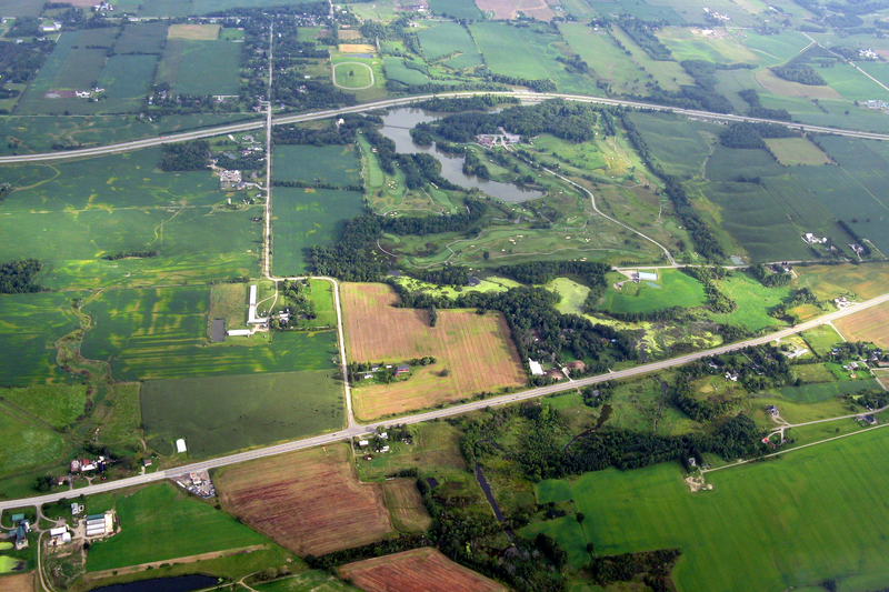
345:{{Information |Description=Aerial view of Highway 403 (further) and former Highway 2 / 53 (closer). The community in the background is
337:
191:
401:
This file contains additional information, probably added from the digital camera or scanner used to create or digitize it.
60:
56:
52:
48:
42:
73:
390:
404:
If the file has been modified from its original state, some details may not fully reflect the modified file.
104:
Aerial view of
Highway 403 (further) and former Highway 2 / 53 (closer). The community in the background is
381:
The following pages on the
English Knowledge (XXG) use this file (pages on other projects are not listed):
346:
105:
119:
385:
333:
349:. The lake is Dunmark Lake. |Source=Derivative of [http://www.flickr.com/photos/paulhami/2813736
248:
204:
229:
430:
325:
314:
309:
186:
64:
37:
251:
372:
182:
The uploader or another editor requests that a local copy of this file be kept.
235:
211:
141:
240:
282:
Click on a date/time to view the file as it appeared at that time.
224:
170:
78:(3,028 × 2,018 pixels, file size: 10.03 MB, MIME type:
442:Creative Commons Attribution-ShareAlike 3.0 files
185:This image or media file may be available on the
364:The following file is a duplicate of this file (
257:https://creativecommons.org/licenses/by-sa/3.0/
8:
263:Creative Commons Attribution-ShareAlike 3.0
406:
284:
93:
416:
408:
383:
370:
7:
437:Aerial photographs of Ontario roads
203:. If you desire to nominate it for
399:
87:
71:
247:This work is licensed under the
239:
234:
228:
210:
174:
21:
356:You cannot overwrite this file.
14:
199:and should not be tagged as a
26:
1:
373:File:403 near Jerseyville.png
192:File:403 near Jerseyville.png
120:Southern Ontario from the Air
31:
207:, notify the tagging editor.
108:. The lake is Dunmark Lake.
458:
391:User:B/Flickr images at en
252:Attribution-ShareAlike 3.0
148:
136:
126:
113:
99:
16:
344:
310:15:43, 22 October 2011
41:Size of this preview:
410:Horizontal resolution
347:Jerseyville, Ontario
106:Jerseyville, Ontario
65:3,028 × 2,018 pixels
418:Vertical resolution
386:Ontario Highway 403
96:
47:Other resolutions:
94:
61:1,280 × 853 pixels
57:1,024 × 682 pixels
425:
424:
352:
274:
273:
218:
217:
201:Commons duplicate
187:Wikimedia Commons
169:
168:
157:
154:Reusing this file
95:File information
449:
407:
342:
341:
322:
270:
267:
264:
261:
258:
249:Creative Commons
243:
238:
232:
225:
214:
178:
177:
171:
151:
131:August 28, 2008
97:
83:
81:
68:
53:640 × 427 pixels
49:320 × 213 pixels
43:800 × 533 pixels
457:
456:
452:
451:
450:
448:
447:
446:
427:
426:
395:
382:
378:
358:
353:
331:
330:
328:
320:
276:
275:
268:
265:
262:
259:
256:
233:
223:
184:
175:
164:
150:
92:
85:
79:
77:
70:
69:
46:
12:
11:
5:
455:
453:
445:
444:
439:
429:
428:
423:
422:
419:
415:
414:
411:
398:
394:
393:
388:
380:
379:
377:
376:
362:
361:
354:
351:
350:
343:
326:
323:
319:3,028 × 2,018
317:
312:
307:
303:
302:
299:
296:
293:
290:
287:
280:
279:
272:
271:
244:
222:
219:
216:
215:
208:
179:
167:
166:
158:
146:
145:
138:
134:
133:
128:
124:
123:
118:Derivative of
115:
111:
110:
101:
91:
88:
86:
40:
36:
35:
34:
29:
24:
19:
13:
10:
9:
6:
4:
3:
2:
454:
443:
440:
438:
435:
434:
432:
420:
417:
412:
409:
405:
402:
396:
392:
389:
387:
384:
374:
371:
369:
367:
359:
357:
348:
339:
335:
329:
324:
318:
316:
313:
311:
308:
305:
304:
300:
297:
294:
291:
288:
286:
285:
283:
277:
255:
253:
250:
245:
242:
237:
231:
227:
226:
220:
213:
209:
206:
202:
198:
194:
193:
188:
183:
180:
173:
172:
165:
162:
159:
155:
147:
144:
143:
142:Paul Hamilton
139:
135:
132:
129:
125:
122:
121:
116:
112:
109:
107:
102:
98:
89:
84:
75:
74:Original file
66:
62:
58:
54:
50:
44:
39:
33:
30:
28:
25:
23:
20:
18:
15:
403:
400:
375:from Commons
366:more details
363:
355:
281:
278:File history
260:CC-BY-SA-3.0
246:
190:
181:
163:
160:
140:
130:
117:
103:
100:Description
72:
22:File history
161:See below.
431:Categories
360:File usage
321:(10.03 MB)
295:Dimensions
149:Permission
27:File usage
292:Thumbnail
289:Date/Time
254:License.
221:Licensing
80:image/png
421:37.8 dpc
413:37.8 dpc
397:Metadata
338:contribs
327:Floydian
205:deletion
32:Metadata
306:current
301:Comment
137:Author
114:Source
90:Summary
76:
197:CSD F8
127:Date
334:talk
298:User
269:true
266:true
17:File
368:):
189:as
433::
336:|
63:|
59:|
55:|
51:|
45:.
340:)
332:(
156:)
152:(
82:)
67:.
Text is available under the Creative Commons Attribution-ShareAlike License. Additional terms may apply.

